

EHoffman
-
Posts
697 -
Joined
-
Last visited
Content Type
Profiles
Blogs
Forums
American Weather
Media Demo
Store
Gallery
Posts posted by EHoffman
-
-
3 minutes ago, Weather Will said:
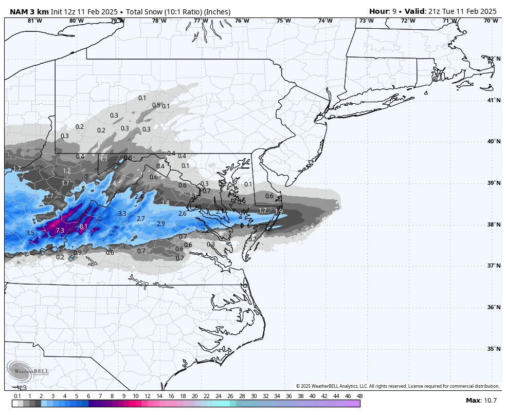
18Z WB 12K NAM

-
 8
8
-
 1
1
-
-
I'm all the way back
-
1
-
-
8 minutes ago, Stormchaserchuck1 said:
How do you see who weenies you?
If you have to ask, you can't afford it
-
2
-
-
1 minute ago, pazzo83 said:
grab a drink, friend.
We all need a better hobby
-
 1
1
-
2
-
 1
1
-
-
Just got home from work what did I miss?
-
7 minutes ago, stormtracker said:
Christ almighty. Help. Valentine’s Day is a racket. I’ll be home in time for the GFS!
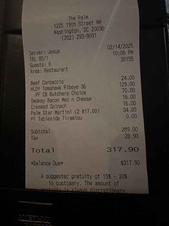
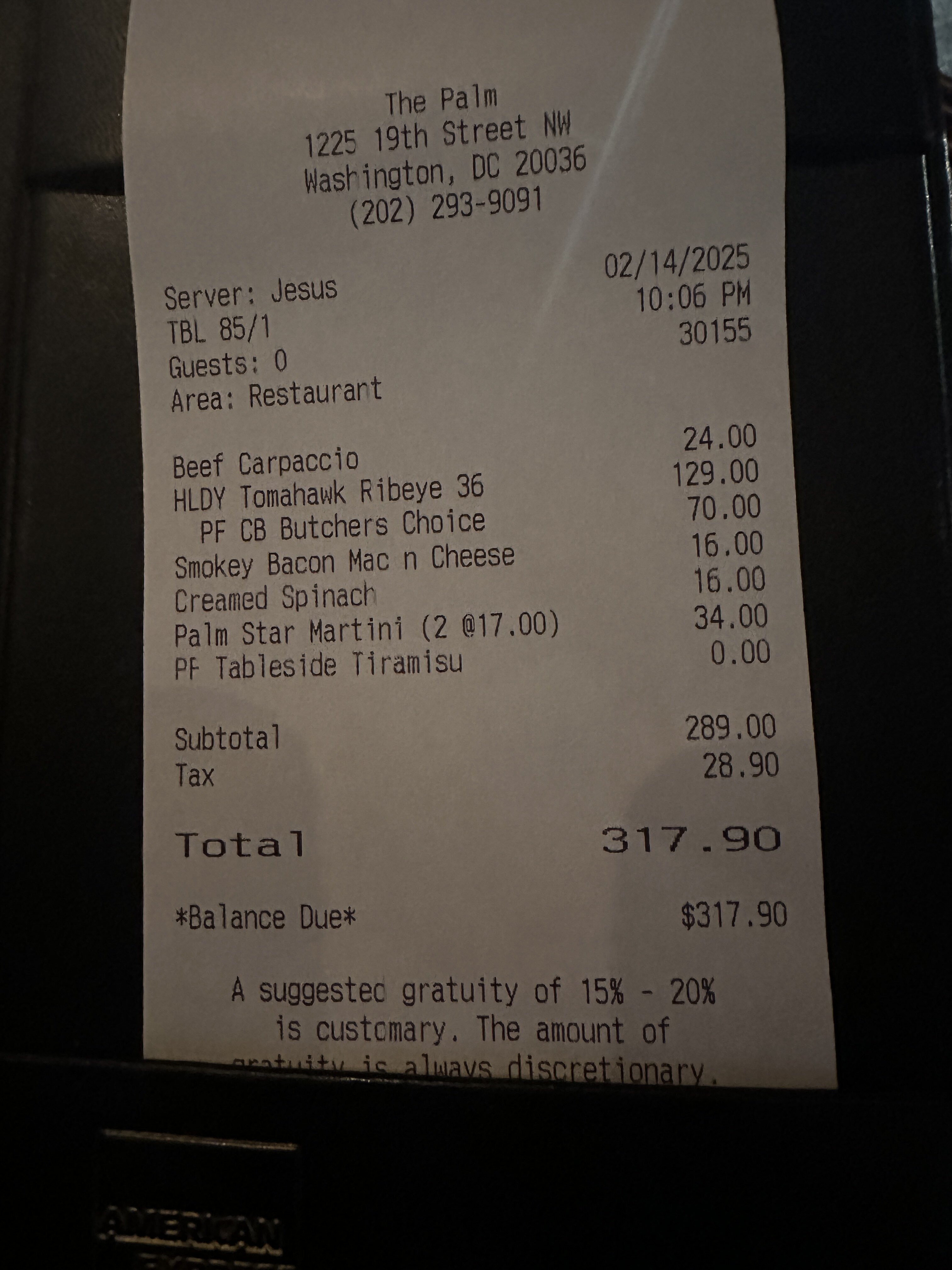
This feels reasonable for 2 at the Palm, which is more of a statement on how expensive dining out in DC is.
-
3
-
-
7 minutes ago, Ji said:
Must read for those on a cliff
https://x.com/cloudsterwx/status/1890581648552411644?s=46&t=C005pd5HNg3Y-KhVU7n3VAI literally think you're the only one even close to a cliff
-
1
-
1
-
-
3 minutes ago, kristia said:
At Silver Diner and overhearing people talking about the impending “historic blizzard”.
The word's out after Doug Kammerer showed the 12z Euro on the news last night
-
1
-
-
7 minutes ago, Scarlet Pimpernel said:
Absolutely. There is definitely cause for caution (though NOT freaking out at every damned model cycle!), which I think nearly everyone here has. I seriously doubt the Euro shows the amazing solution we saw at 12Z, that is probably an upper end or nearly so. At the same time, I don't think a slight "decrease" in snow amounts would mean "OMG, panic, the Euro is going the way of the GFS!!". Key for me at least is to see the same overall evolution, and hope the GFS/GEFS at some point soon starts indicating the same. If you look at the range of reasonable solutions, I have to think we're looking at a solid, decent SECS to MECS event, and perhaps more if things phase just right. No, we may not get 20" but I would still love to see a widespread 6-10" or 8-12" of cold freakin' powder that would stick around for a few days at least, given how cold the temperatures look!
That's cool I got upset the NAVGEM was OTS earlier today
-
2
-
-
12 minutes ago, NorthArlington101 said:


Delete this
-
1
-
2
-
 1
1
-
-
1 minute ago, stormtracker said:
Anybody have important plans Thursday?
I'm gonna drink a lot of beer and stay up ALLLLL night
-
2
-
-
1 minute ago, Ji said:
the special ones dont just show up 3 days out...lol...i am glad we are having these runs today. the storm genesis is only 67 hours away LOL
96-24 =...about 67. Math checks out
-
Just now, psuhoffman said:
This ones happening
This means more than any model run can, thank you.
-
2
-
1
-
-
Just now, AlexD1990 said:
Can't say ive ever seen it even at that range.
The week of constant hits leading up to 2016 had pink/white maps every run
-
Absolutely FOLK'd
-
2
-
-
Barely gets out of the teens on CMC during the event. 20:1 powpow the entire storm.
-
4
-
-
2 minutes ago, stormtracker said:
Because you got 10"?
Nah because of what could have been. We don't get HECS often and to miss one by a hair would be disgusting. Also I'd be crawling back next winter.
-
All coping aside if the GFS verified I'd probably quit weather
-
1
-
 4
4
-
-
Just now, stormtracker said:
Can't say I hate this run
We literally don't wanna be in the bullseye at day 7. It's fine.
-
1
-
-
I was working tonight, Navy Yard (work) had 4-5" or so, up in Admo maybe 5-6 and noticeably colder up here too. Really solid, pretty snow. Also radar looks decent maybe we can squeeze out another inch?
-
1
-
-
First legit steady snow in AdMo.
-
1 minute ago, NorthArlington101 said:
Saying this mostly to myself... anything before 4pm is a bonus. Not expecting of this that falls before 4pm to stick.
I like to cope in this way too during marginal events.
-
1
-
-
Quick progression from flurries to steady light snow in NW.
-
2
-
-
That stuff in Warrenton looks awfully juicy to me and it's heading right for DC.
-
1
-

FOLKS Feb 19-20 Debacle
in Mid Atlantic
Posted
Sun angle is no joke nowadays.