

OhioWX
-
Posts
173 -
Joined
-
Last visited
Content Type
Profiles
Blogs
Forums
American Weather
Media Demo
Store
Gallery
Posts posted by OhioWX
-
-
Transition has begun. Still mostly sleet, but big wet flakes are mixing in.
-
Gravity waves are very evident on KILN. Snow is coming down HEAVY in Cincy. It's so close...
I live right off of I-71. Been hearing a lot of sirens. Roads have to be very dangerous.
-
28 minutes ago, HighTechEE said:
The 8pm obs all Cincy stations is finally back to snow, but most of the Dayton area still sleet.
False hope. Sleet's coming down heavy in Mason again.
-
Dry slot hasn't been too dry. Sleet's been nonstop for almost 5 hours.
-
Just now, jaf316 said:
But I'm sure Thursday will work out. What could possibly go wrong...?
Better question: What could possibly go right?
-
 2
2
-
-
1 hour ago, pondo1000 said:
Telln ya, 4 inches of sleet or bust!!! LOL
I'll tell you what, the sleet accumulation (probably a little snow mixing in) has been quite impressive.
-
Just now, miamarsden8 said:
I'm concerned about that dry slot in western Kentucky. I think that's going to nuke snow totals around here. I think I'm boned at this point if that dry slot doesn't fill in...
Crap.
I'm gonna end up with no snow before that dry slot arrives. Getting absolutely pelted with sleet though.
-
1 minute ago, pondo1000 said:
Heluva sleet storm here. One for the ages!
As disappointed as I am about the snow, the sleet has been very impressive I must admit.
-
Just now, AuerHaus said:
Still just sleet here in city of Cincinnati/Norwood/Pleasant Ridge. :sad:
Same here in Mason. NEXT!

-
Just now, miamarsden8 said:
In Fairfield, at least from my window, it's light snow. It's literally like a 15-mile difference. It's absurd.
Amazing. That snow/sleet line is always very, very sharp.
-
Sleeting in SW Ohio. You hate to see it. Hopefully it'll switch over soon, but I'm not optimistic at all about decent snowfall totals.
-
1
-
-
Precipitation is about to move in. To snow, or not to snow...
Edit: Sleet it is.
-
9 minutes ago, Snownado said:
I wonder what model TWC uses. They are showing 5-8" for Indy, with the heaviest snow confined to Northern Kentucky and Ohio. 8-12" for Louisville and Cincinnati.
I'm questioning if 8-12" will occur in and around Cincy with the increasing possibility of sleet.
-
12z HRRR and NAM have me right on the sleet/snow line...
 1 minute ago, buckeye said:
What do you guys use for a good radar site? I can't stand the NWS update....wth were they thinking?
RadarScope. It's worth it.
-
5 minutes ago, naptown said:
Little disappointed on the NE side of Indy with only 1" with the first round.
About the same NE of Cincy. You'll feel better looking at KLZK radar.
-
7 minutes ago, Snownado said:
So did things stop trending NW ? Seems like Ohio is back in play again ?
I don't think Ohio has ever been out of play. Bullseye just appears to be shifting west. Significant snowfall still should be expected statewide.
-
I'm very used to the models teasing us around here, but it never fails to be disappointing. Still, fingers crossed we don't get robbed again.
-
Cautiously optimistic in SW Ohio. The overachiever on the 8-9th and now this just feels too good to be true. Year after year of disappointing winters... I’m not used to being spoiled like this.
-
2
-
-
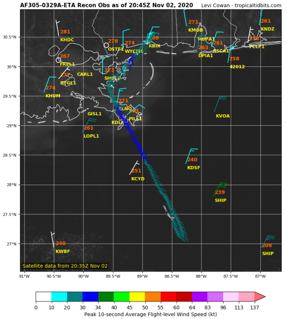
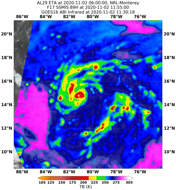
This most recent pass confirms rapid intensification is still occurring. If current recon doesn't confirm a category 5 by the time it departs, the next one, which is currently en route, should.
-
I'm not convinced Eta is done rapidly intensifying. I guess we'll see what this next pass shows.
-
145kts/923mb
-
 Oy vey!
-
 1
1
-
 1
1
-
-
This is really impressive.
-
I somehow doubt this is only a minimal hurricane...

-
1
-


February 14-16 Winter Storm Part 2
in Lakes/Ohio Valley
Posted
I was starting to doubt I'd ever see snow today, but here it comes. Very big, wet flakes coming down heavy.