

OhioWX
-
Posts
173 -
Joined
-
Last visited
Content Type
Profiles
Blogs
Forums
American Weather
Media Demo
Store
Gallery
Posts posted by OhioWX
-
-
Disgusting.
-
6 minutes ago, CryHavoc said:
That snyder storm has bonkers rotation. Absolutely some of the best I've seen all year.
-
3 minutes ago, OhioWX said:
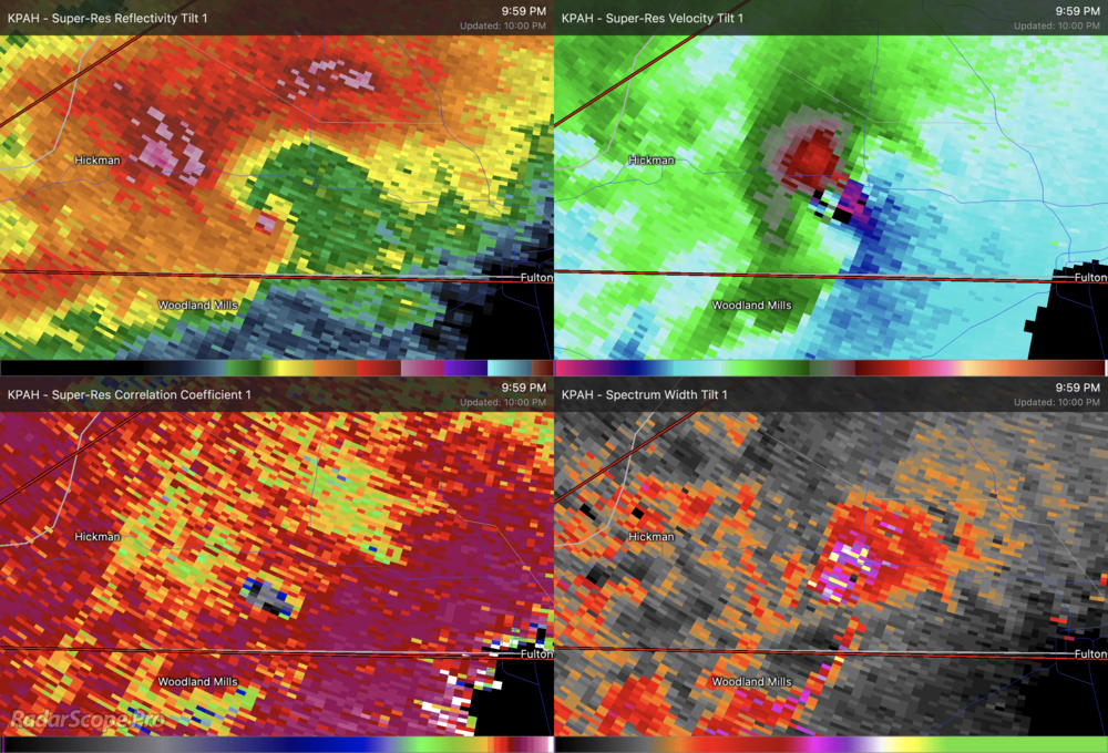
That storm near Frederick, OK has got my eye... hard to tell since it's so close to the radar but is that a debris ball?
New scan came in... wow, I think that answered my question. That came out of nowhere!
-
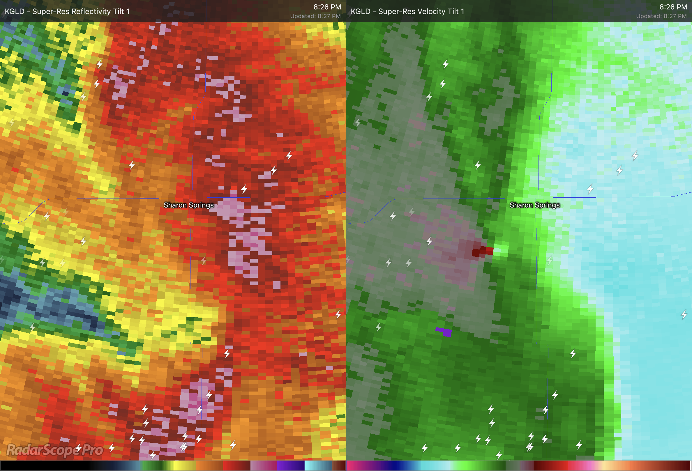
That storm near Frederick, OK has got my eye... hard to tell since it's so close to the radar but is that a debris ball?
-
Likely a tornado near Sharon Springs, KS.

-
31 minutes ago, jpeters3 said:
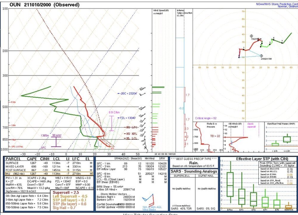
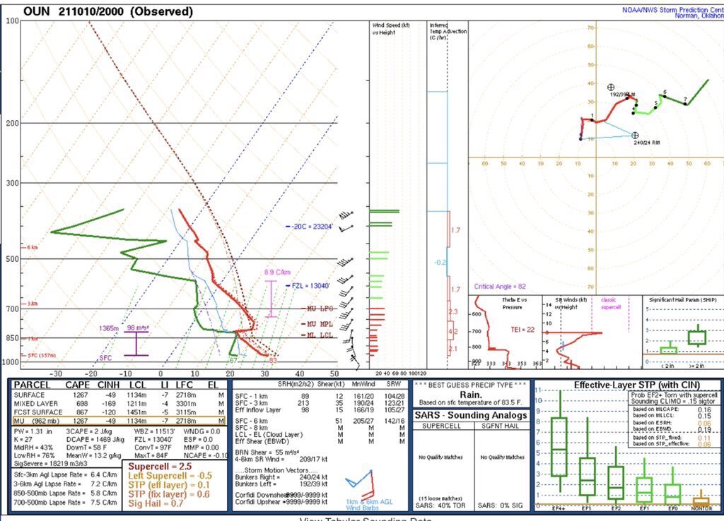
A lot to erode in that sounding. Particularly, -170 J/kg of MLCIN is pretty prohibitive. This is quite a bit higher that CAM progs at the same time. I suspect we might have trouble getting CI anywhere away from the front/triple point.
Wouldn't cold air aloft be enough to erode the cap over time, especially near the triple point? I'm concerned about the cap keeping significant convection from developing until later this evening/tonight when the environment is becoming increasingly favorable for tornadoes.
-
Special 20z OUN sounding. Once that cap erodes...
-
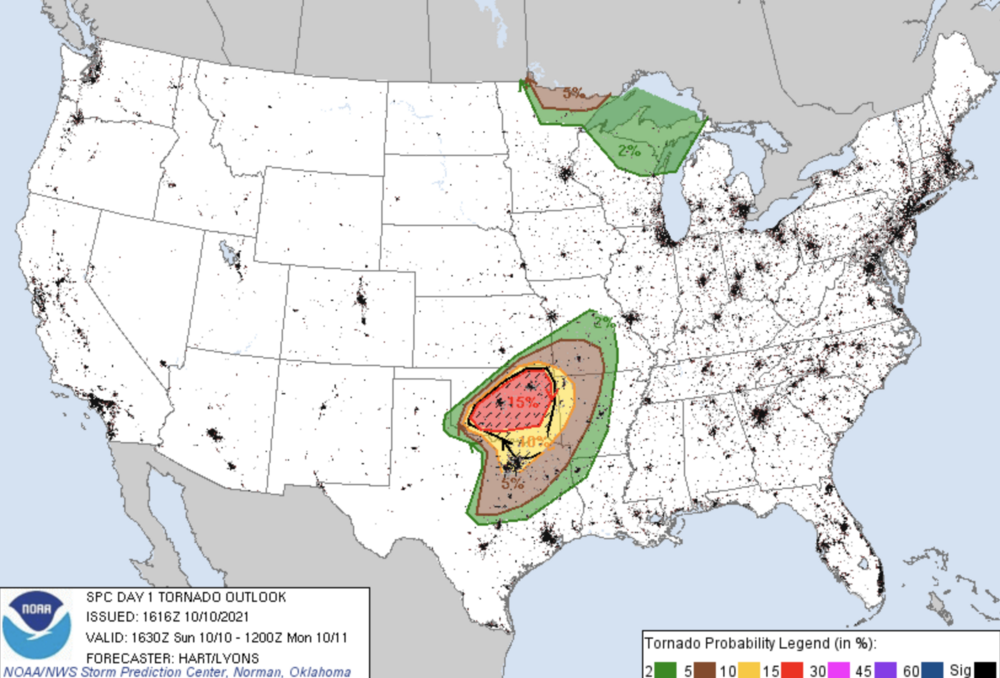
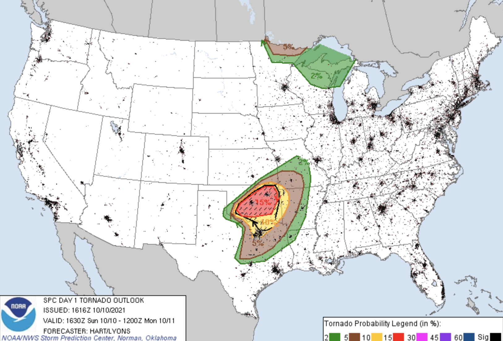
Latest mesoscale model runs have been very concerning and have trended towards more discrete activity in Oklahoma, notably threatening the Norman/Moore/OKC area and even up into Tulsa later on tonight. Latest SPC outlook expands the moderate risk to the north, putting the mentioned cities deeper within the 15% hatched tornado contour. In addition, DFW has now been included in the 10% tornado contour.
-
The rate in which Sam has intensified this afternoon is stunning. I'm anxious to see what recon will find.
-
The original vortex appears to be reintensifying and might be trying to become dominate again. The "new" vortex is fizzling out.
-
3 minutes ago, stormtracker said:
Last pic from IR is pretty bad. Starting to look classic at this point.
No doubt Ida is putting on a show for recon.
-
Eyewall is coming ashore. This looks really bad.
-
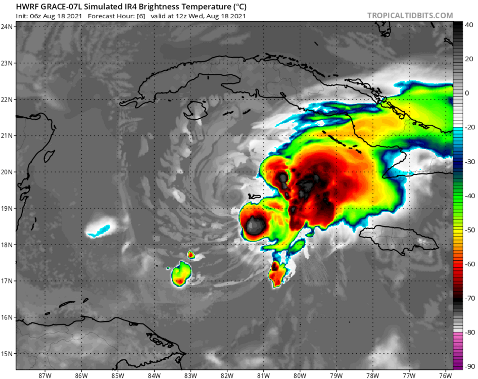
The typically aggressive HWRF on its latest run is a far cry from reality.
-
 1
1
-
-
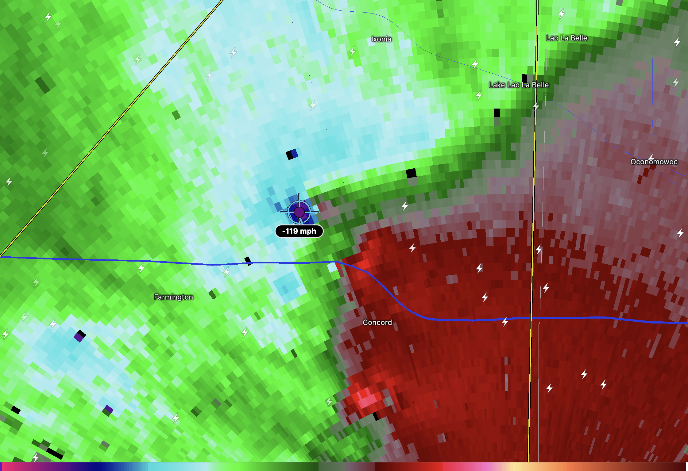
I'm very concerned about Concord. Looks to have taken a direct hit by a possibly intense spin-up tornado.
Another one may have tracked right over I-94 just north of Farmington.
-
Holy crap!

-
The line is really ramping up right over Eau Claire.
-
TOG on John Humphress' stream.
-
The last few HRRR runs show an interesting trend for tonight. It shows an intense MCS develop and move across much of Nebraska, yet little to no convection across Kansas. With this scenario, a 45% hatched wind probability could easily verify in Nebraska, but the 15% hatched tornado probability would be a bust with minimal storm development in the area. We'll see how it pans out, but something to be wary of, especially for those chasing in Kansas.
-
2 minutes ago, Wmsptwx said:
Sounds like some moderate structural damage reported in Newnan.
What makes you say moderate structural damage? I haven't seen or heard much in the way of damage reports from the area.
-
15 minutes ago, Gino27 said:
99% sure I’m the luckiest guy on the planet right now. Sorry guys!
Congrats! That band is what dreams are made of. Some of the most impressive snow rates I've personally seen while it was over me.
-
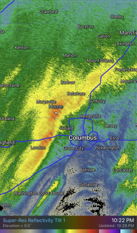
Gravity waves are making their way over to Columbus. Good luck all!
-
 1
1
-
-
Just now, miamarsden8 said:
I guess it depends on what you consider significant. It could probably be here til like 1 am, which could give you theoretically 6-ish inches. That's significant.
I'd be thrilled with 6", but those snowfall rates won't last long. That initial batch of heavy snow moved through very quickly. Still, some impressive bands yet to come through. We'll see...
-
Very impressive snowfall rates around here. ILN tweeted about rates as high as 1.5" per hour. Sadly, I don't think it'll stick around long enough for any significant accumulation.
-
2
-
-
I finally got my order of jumbo flakes .

-
1
-


“Let’s Talk Winter”
in Lakes/Ohio Valley
Posted
Big flakes have begun to mix in with the heavy sleet in Mason.