

Kaner88
-
Posts
306 -
Joined
-
Last visited
Content Type
Profiles
Blogs
Forums
American Weather
Media Demo
Store
Gallery
Posts posted by Kaner88
-
-
Hard to tell since I'm staring at my porch light but it looks like MBY (few miles north of ORD) will kick off with light snow rather than rain. Radar would suggest some heavy stuff but seems like the first precipitation is beating back the dry slot.
-
CC loop (https://weather.cod.edu/satrad/nexrad/index.php?type=LOT-N0C-1-24) showing the rain/snow line making a stand in the northern suburbs, it appears. Also edging east into the western suburbs, nighttime coming to the rescue

-
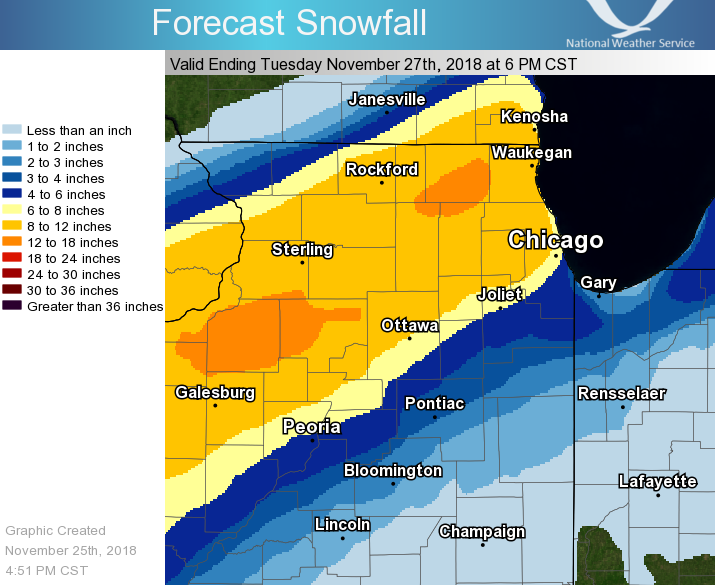
Updated LOT snowfall outlook now with two spots of >12" totals:
Edit: bad image
-
Last few posts got me thinking, kinda seems like the stuff moving north towards Chicagoland/Rockford etc might pose a threat of kicking off as rain at first. I say that solely from looking at 22z OBS for the state and not much else, so I may very well be off my rocker, but the possibility is piquing my interest.
-
Text from the warning (DuPage also included):
Quote...BLIZZARD WARNING IN EFFECT UNTIL 9 AM CST MONDAY... * WHAT...Blizzard conditions expected. Winds gusting as high as 45 mph will cause whiteout conditions in blowing snow. Significant drifting of the snow is likely. Total snow accumulations of 7 to 11 inches, with localized amounts up to 13 inches, are expected. * WHERE...DuPage and Cook Counties. * WHEN...Until 9 AM CST Monday. Conditions ramping up between 6 PM and 9 PM this evening, first across northwest areas. * ADDITIONAL DETAILS...Travel could be very difficult. Snow covered roads and significantly reduced visibility are expected. Snowfall rates in excess of 2 inches per hour are possible. This snow is expected to be very heavy and will be difficult to shovel. The strong winds and heavy snow may cause falling tree limbs and possible power outages.
-
 1
1
-
-
Weather alarm just went off, Cook county under Blizzard warning
-
3
-
-
Neat "Situation Report" PDF from LOT, highlighting three areas in north IL and breaking down their specific impacts. https://www.weather.gov/media/lot/sitreport/SitReport1.pdf
-
1
-
-
Snow seems to be intensifying a bit. Gonna need things to fill in pretty quick here otherwise us ORD-area folks might get pushed out of the fun for a bit, per radar
-
1
-
 1
1
-
-
Snow still going a few miles north of ORD, nice dusting on the grass & roofs now. 18z NAM posted above is something else
-
Just now, TimChgo9 said:
7 miles south of ORD, now down to 38, and rain. Looks like the changeover may be approaching
Predominantly snow a few miles north of ORD, should be happening soon for you
-
All sleet & snow now just north of ORD. Light intensity but it looks like the change to wintry precipitation has happened
-
2
-
-
Now we're changing, got a mess of stuff falling from the sky. Predominantly rain but big flakes poking in.
-
2 minutes ago, Sciascia said:
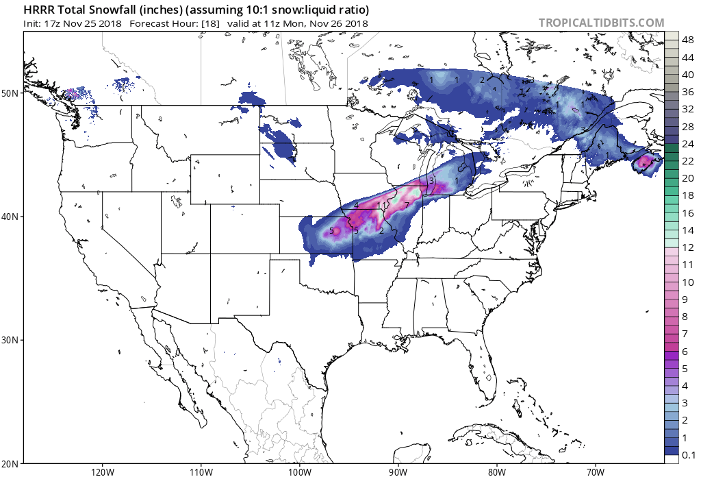
New HRRR hot off the presses:
>1.7" precipitation in northeast IL, at least 1.1" throughout ~all of northern IL. Have to think it's the HRRR up to its usual (excessive) games but fun to watch nonetheless
-
Just now, Powerball said:
Rockford looks to be reporting all snow, while DeKalb is reporting sleet.
Seeing the occasional piece of sleet/slush/something mixing in with the rain just north of ORD as well
-
Rain still falling for the swath of this band I'm in, but that's a heck of a band to see with a winter storm. Just imagine if that were all snow...

-
Updated LOT snowfall forecast, all but eliminated the 12"+ from northeast IL. Marginal move, though, 8-12" still a force to be reckoned with

-
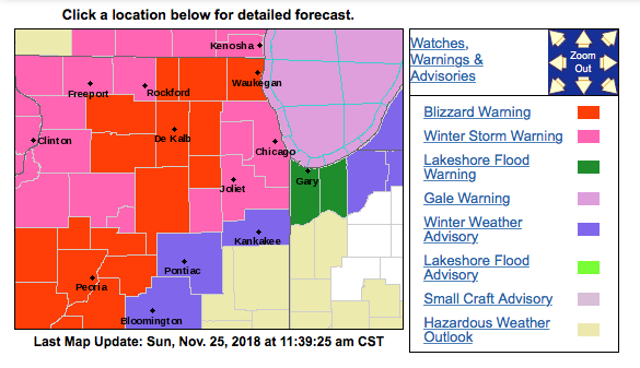
Screenshot of the new blizzard warnings for LOT. Point & click upped from a 6-10" range to 8-12" as well
-
Looking like it wants to start making that switch but still rain here a few miles north of ORD.
-
 1
1
-
-
8.0" in ORD, ~IMBY seems like a good baseline. Looking forward to some good >12" readings out to the north & west.
-
06z NAM looks like it'll make a handful-of-miles tick south, broadly same snow amounts as seen on the 00z run, through hour 24.
-
Snowfall thru hour 30, still coming down in east IL into IN & MI, you get the picture. Winter wonderland not even two days removed from Thanksgiving weekend

-
Snowfall thru hour 25. Hours of just pouring snow in NE IL, simulated reflectivity makes it look like the heaviest band doesn't even move. Fun run, if nothing else

-
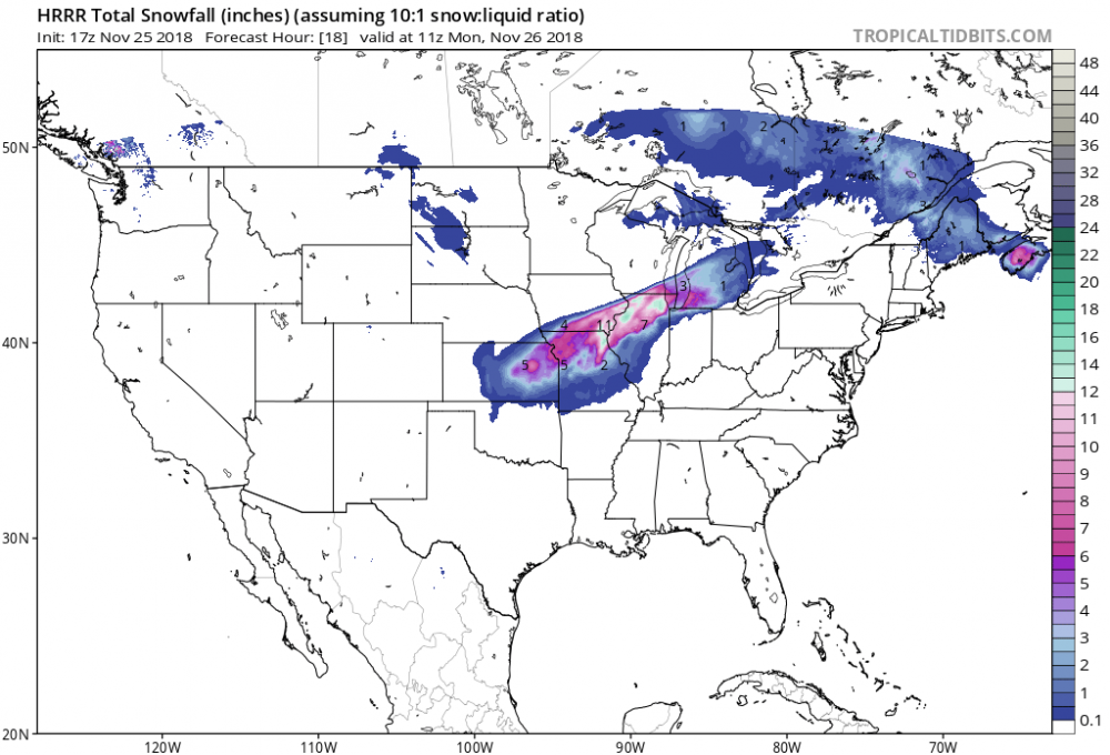
Comparing the 06z HRRR so far thru hour 18 with previous runs looks like the main snow band has ticked south and/or the main band that lifts up through N. IL has gotten juiced up.
Edit: This run's gonna be wicked.
-
2 minutes ago, Jackstraw said:
Meso agrees...
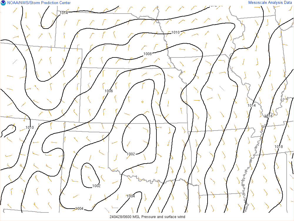
Pretty trivial I imagine but just comparing some of the 0z suite to the above image: HRRR & RAP struggling with strength, wanting it to be ~2-3mb stronger than it is. NAM 3km looks pretty spot-on with both strength and location. We'll just have to see what happens
Nov. 25th-26th Midwest Snowstorm Potential
in Lakes/Ohio Valley
Posted
Just got back in from the first round of shoveling, wanted to get the real wet stuff out of the way before things get real amped, judging by those radar returns pivoting north into northeast IL. Snow intensity reminds me of the GHD blizzard, wind not too bad yet. Did see a branch or two snap while out there.