

WXMan42711
-
Posts
106 -
Joined
-
Last visited
Content Type
Profiles
Blogs
Forums
American Weather
Media Demo
Store
Gallery
Posts posted by WXMan42711
-
-
-
1 minute ago, mjwise said:
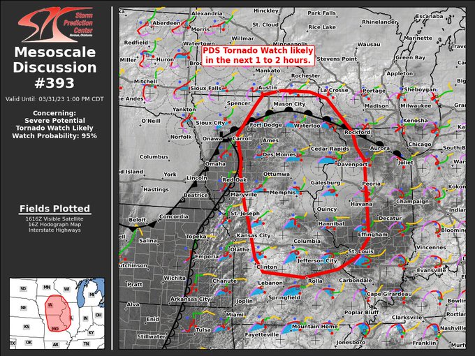
I think this might be the first day one high risk day with two non-contiguous high risk areas. At least I can't find any others.
april 14, 2012 out on the high plains. april 13's day 2 featured two separate high risks and then april 14 started out with two before they eventually became one.
-
 1
1
-
-
not necessarily in this region of the forum but the southern end of the moderate will also be upgraded to high. significant day unfolding for a large part of the country.
-
1
-
-
 Mesoscale Discussion 0390
   NWS Storm Prediction Center Norman OK
   1037 AM CDT Fri Mar 31 2023

   Areas affected...portions of southeastern Iowa...northwestern
   Illinois...and far northeastern Missouri

   Concerning...Outlook upgrade

   Valid 311537Z - 311630Z

   SUMMARY...Portions of the Moderate Risk over southeastern IA,
   northwestern IL, and far northeastern MO will be upgraded to a
   categorical High Risk in the 1630 UTC Convective outlook.

   DISCUSSION...An upgrade to a tornado-driven High Risk (30%
   probability) is expected for the 1630 UTC outlook. Environmental
   conditions are quickly becoming favorable to support the potential
   for numerous strong to potentially violent and long-track tornadoes
   across portions of southeastern IA, northwestern IL, and far
   northeastern MO. Please see the forthcoming Day 1 outlook update for
   more information.

   ..Lyons/Smith.. 03/31/2023
-
 1
1
-
-
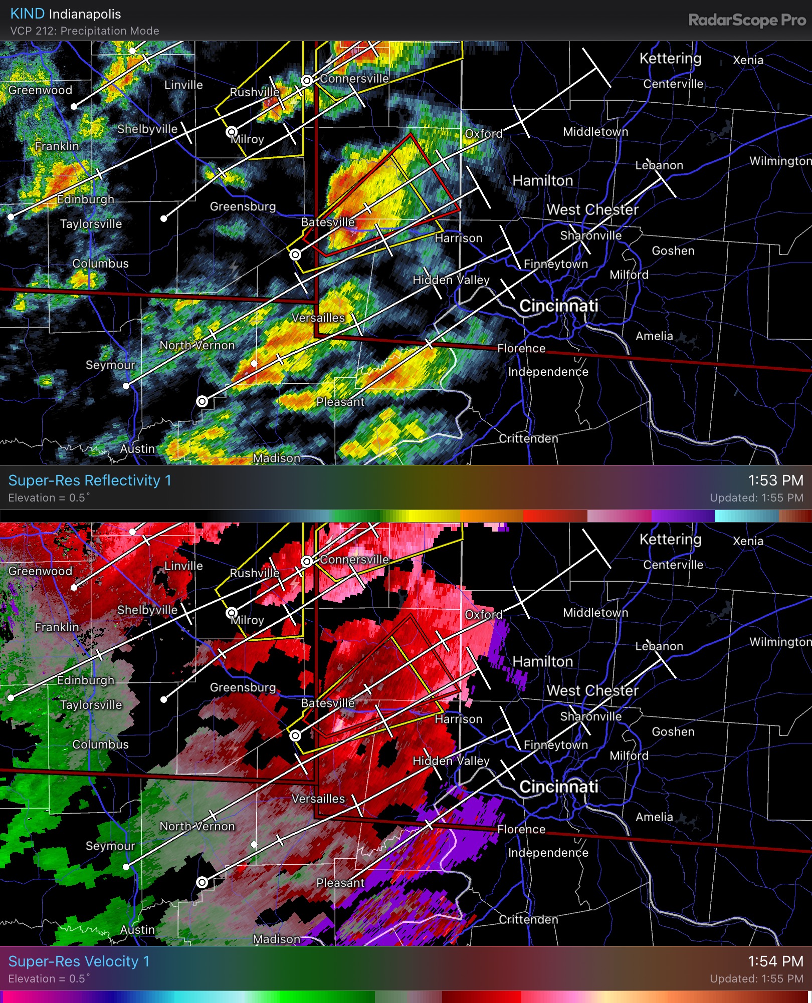
ILN calling it a radar confirmed tornado now, heading northeast towards the dayton metro.
QuoteOHC017-113-165-272015- /O.CON.KILN.TO.W.0005.000000T0000Z-230227T2015Z/ Butler OH-Warren OH-Montgomery OH- 244 PM EST Mon Feb 27 2023
...A TORNADO WARNING REMAINS IN EFFECT UNTIL 315 PM EST FOR NORTHEASTERN BUTLER...NORTHWESTERN WARREN AND SOUTHERN MONTGOMERY COUNTIES...
At 244 PM EST, a confirmed tornado was located near Carlisle, moving northeast at 45 mph.
HAZARD...Damaging tornado.
SOURCE...Radar confirmed tornado. Radar shows tornado debris in the air.
IMPACT...Flying debris will be dangerous to those caught without shelter. Mobile homes will be damaged or destroyed. Damage to roofs, windows, and vehicles will occur. Tree damage is likely.
Locations impacted include... Dayton, Kettering, Miamisburg, Springboro, Franklin, Bellbrook, Moraine, Carlisle, Oakwood, West Carrollton, Riverside, Germantown, Centerville, Poast Town Heights and Woodbourne-Hyde Park. This includes I-75 in Ohio between mile markers 40 and 52.
spotter report from Germantown, OH:
Source: AMATEUR RADIO UTC Valid: 2023-02-27T19:48:00Z
Remark: POSSIBLE TORNADO FROM MULTIPLE SPOTTERS -
16 minutes ago, nwohweather said:
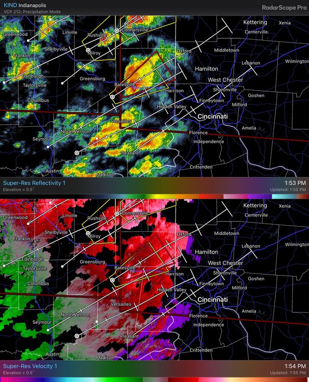
miraculously nothing has been reported but that couplet passing east of brookville, IN does not want to quit
EDIT: this could become a problem for the dayton metro within the next hour.
-


spotty sun out ahead of this one. -
looks like there was a brief lil spinner about 15 miles northwest of KLOT
-
hrrr continues to bring more instability up to the ohio river. i think the tornado risk along the ohio river TP is being understated. cincy could very well get in on the action.
-
next weds/thurs could be interesting near and south of the ohio river...
-
1
-
-
thought we’d have rain for quite a bit longer but areas just SW of cincy are starting to see big flakes and sleet is beginning to fall inside the 275 loop … will be interesting to watch
-
4 minutes ago, WestMichigan said:
18Z GFS says SW OH is in the game.

-
6 minutes ago, RogueWaves said:
LOL, Watches expanded S in Ohio. Which office is winning that battle??
would love some more of it here in cincy but i have no room to complain thanks to sunday's surprise.
local mets are steadily trying to raise awareness with each new model run but i dont want to bite yet.
-
woke up to 5.5" on the ground yesterday morning, completely oblivious to the fact that it was supposed to snow. easiest 5.5" i've ever had to shovel, though, as it was the wet kind. I know a couple towns just west of Cincy saw 6"+
-
1
-
-
Quote
URGENT - IMMEDIATE BROADCAST REQUESTED
   Tornado Watch Number 583
   NWS Storm Prediction Center Norman OK
   215 PM CST Tue Dec 13 2022

   The NWS Storm Prediction Center has issued a

   * Tornado Watch for portions of
     Southern Arkansas
     Western and Northern Louisiana
     East Texas

   * Effective this Tuesday afternoon and evening from 215 PM until
     1000 PM CST.

   * Primary threats include...
     Several tornadoes and a couple intense tornadoes likely
     Scattered damaging winds likely with isolated significant gusts
       to 75 mph possible
     Scattered large hail events to 1.5 inches in diameter possible

   SUMMARY...Thunderstorms over east Texas are expected to intensify
   through the afternoon and evening as they track into parts of
   Louisiana and southern Arkansas.  Tornadoes, including a risk of
   strong tornadoes, are expected with the most organized storms.
   Damaging winds and hail are also possible.
80/60 probs

-
2 minutes ago, Chinook said:
confirmed tornado as of about 6:05 or 6:10 eastern time, Bassfield
MS state trooper reported this; relayed by WLBT in Jackson, MS.
live coverage: https://www.wlbt.com/livestream/
-
Quote
Area Forecast Discussion
National Weather Service Memphis TN
553 PM CST Mon Nov 28 2022

...New AVIATION...

.DISCUSSION...
(This evening through next Sunday)
Issued at 336 PM CST Mon Nov 28 2022

A potential high-end severe weather event remains on track to
impact the Midsouth on Tuesday and Tuesday night. Tornadoes, a
few strong and long-lived, will be possible.

Low level moisture and instability will surge north through the
lower MS River valley Tuesday morning, in advance of a deepening
upper level longwave trof over the Great Plains. Initial round of
late morning/early afternoon storms will likely root in an elevated
layer, associated with a 925mb warm front surging north from the
Arklamiss. These storms will likely present a marginal severe
threat in the early afternoon, with midlevel lapse rates of 6.5
C/km accompanying MUCAPE below 300 J/KG.

The potential for storms to become rooted in a near-surface layer
will increase mid to late afternoon, aided by modest surface
heating and dewpoints rapidly warming into the mid/upper 60s.
During this period, convection-allowing model (CAM) consensus
depicts 850mb wind increasing from 40 to 60 KTs, elongating
hodographs and increasing 0-3km helicity to values in excess of
500 m2/s2.

Uncertainty remains regarding the extent and timing of low level
inversion erosion in the absence of strong surface heating. This
will largely determine the northward extent of the tornado threat
in the late afternoon, prior to steep midlevel height falls.

While some uncertainty remains regarding the onset timing of
surface-based convection and associated tornado threat, the
parameter space will become quite concerning by early Tuesday
evening, aided by CAPE in excess of 1000 J/kg and steep height
falls and strongly bowed hodographs. Low LCLs (cloud bases) and
storm movement in excess of 60 mph will make for particularly
dangerous convective environment, where tornadic storms appear to
arrive suddenly, preceded by little if any visual or audible
notice. Definitely a time to keep a weather radio with battery
backup and a fully-charged cell phone nearby.

Beyond Tuesday`s severe event, generally quiet weather is
forecast from through the upcoming weekend, under fast zonal flow
aloft. A northern branch upper low will pass through the Great
Lakes on on Saturday, modestly depressing midlevel heights over
the Midsouth and aiding the passage of a Pacific cold front. A few
showers will accompany the frontal passage, with only limited
chances for thunder.

PWB

&&
low lcls + fast storm motion + strong tornadoes + nighttime + lack of general awareness is never what you want to see.
-
2
-
 1
1
-
-
so, what’s keeping this from going off?

-
Mesoscale Discussion 1917
   NWS Storm Prediction Center Norman OK
   1128 AM CDT Fri Nov 04 2022

   Areas affected...southeastern Oklahoma across north-central and
   northeastern Texas

   Concerning...Severe potential...Tornado Watch likely

   Valid 041628Z - 041730Z

   Probability of Watch Issuance...95 percent

   SUMMARY...Potential for severe/supercell storms is expected to
   gradually increase into the afternoon.  All-hazards severe risk is
   expected, including likelihood for for significant tornadoes,
   widespread damaging winds, and large hail.  A tornado watch will
   likely be required by early afternoon.

   DISCUSSION...Latest radar loop shows convection increasing in
   coverage/intensity along an advancing cold front now stretching from
   southeastern Kansas across central and southwestern Oklahoma and
   into western North Texas.  Ahead of the front/frontal convection, a
   moistening boundary layer is indicated, with mid 60s dewpoints into
   southeastern Oklahoma and low 70s dewpoints now spreading toward the
   Dallas/Fort Worth Metroplex.

   The low-level moistening is occurring beneath a rather substantial
   capping inversion, revealed by the recent 15Z FWD RAOB, and which
   extends across the warm sector as suggested by the character of the
   low cloudiness as revealed by recent visible satellite imagery.
   This cloudiness will continue to retard heating, and thus low-level
   destabilization, over the next several of hours, but cooling aloft
   -- associated with the advancing upper system -- will allow gradual
   airmass destabilization, particularly above 700mb.

   Weak warm-advection-induced showery convection indicated across the
   warm sector continues to gradually increase, with some small/higher
   reflectivity cores beginning to become apparent.  Expect a gradual
   ramp-up in this convection to continue -- with eventual growth into
   cellular/lightning-producing cells as cooling aloft continues within
   the capping layer and above.

   Once deep convection becomes established, rapid intensification to
   severe levels is expected, as very favorable shear -- provided by
   low-level southerly flow veering to south-southwesterly and
   increasing to 50 kt at around 1km along with additional veering
   above -- resides across the warm sector.  Risk for
   strong/significant tornadoes will then ensue, as storms acquire
   strong rotation.  Large hail and locally damaging winds are also
   expected.

   Risk for damaging winds will likely increase later this afternoon
   and beyond, as convection strengthens linearly along the front with
   time, likely merging gradually with pre-frontal cellular convection
   to evolve into a well-developed squall line by early evening.  This
   anticipated evolution will likely require tornado watch issuance
   within the next hour or two, extending eastward across southeastern
   Oklahoma and North Texas toward the Arklatex region.

   ..Goss/Hart.. 11/04/2022
-
concerned about the north/northwest suburbs of chicago
-
-
-
tornado on the ground northwest of springfield ohio. meanwhile, isolated tornado warnings are coming and going across the slight risk area


-
moderate for tornadoes and hail, spc seems to think that nw texas and sw oklahoma will see some discrete supercells due to lack of convection this AM


 Quote
Quote...THERE IS A MODERATE RISK OF SEVERE THUNDERSTORMS FOR PARTS OF NORTHWEST TEXAS AND THE SOUTHEAST TEXAS PANHANDLE...SOUTHWEST OKLAHOMA... ...SUMMARY... Numerous severe thunderstorms are expected across parts of the southern Great Plains this afternoon through tonight. A few strong tornadoes and giant hail is most probable across the southeast Texas Panhandle into portions of southwest Oklahoma and north Texas. ...Southern Great Plains... Complicated forecast today/tonight as a broad/destabilizing warm sector enlarges as a warm front advances northward today. Considerable forecast uncertainty remains evident for a multitude of possible scenarios, some of which differ both spatially in terms of severe hazard and intensity. Nonetheless, with the lack of morning convection across northwest TX into the TX Panhandle, thinking is this area will remain void of convection through the midday/early afternoon. Consequently, it seems a categorical Moderate Risk is warranted for dryline/triple point storms. Visible-satellite imagery late this morning shows a cirrus canopy across much of the outlook area. A warm front is rapidly moving northward across north TX with upper 60s F dewpoints reaching the Red River as of 16z. A destabilizing boundary layer beneath a capping inversion, which seems likely to hold through the early afternoon, will become quite unstable by peak heating with 3000-4000 J/kg MLCAPE forecast over northwest TX by 4pm. The RAP/HRRR seems to have the best handle on morning storm activity compared to the ARW and associated CAM models. In general, model guidance indicates storms will develop over the TX Panhandle during the mid-late afternoon with more widely spaced thunderstorms farther south along the dryline. Very steep 700-500 mb lapse rates, enlarged low-level hodographs via easterly component to low-level flow, and long hodographs all suggest discrete supercells will be the preferred mode over the TX Panhandle into northwest TX late this afternoon. Very large to giant hail (potentially 3+ inches in diameter) and a few strong tornadoes are possible during the late afternoon into the early evening as this activity moves into parts of western OK/far western north TX. Less certain but a plausible scenario involves free warm sector development farther east across parts of OK and perhaps north TX. A potentially significant tornado risk could develop if discrete supercells were to develop within an increasingly moist/strongly sheared environment during the late afternoon/early evening. By early to mid evening, the strengthening of a southerly LLJ and coalescing of storms/outflow will probably lead to the development of a severe MCS moving east across parts of OK. Severe gusts, possibly greater than 65 kt, and tornadoes will become the primary severe hazards with time. As this activity approaches the western part of the Ozarks, a lessening in the severe risk is anticipated late overnight. ...Southeast VA and the Carolinas... Not much change from the previous forecast in the overall thunderstorm scenario for VA/Carolinas. A low-amplitude shortwave trough over the Lower Great Lakes will move east into southern New England this evening. To the south of this wave, a cold front will push southeast across the Lower Mid-Atlantic into the Carolinas. Convergence along the cold front and coastal sea breezes should support scattered thunderstorms this afternoon. While deep-layer shear will be modest, it should be adequate for multicells capable of isolated severe hail and damaging winds. Convection should largely shift offshore and/or weaken after dusk.

March 31st Severe Threat
in Lakes/Ohio Valley
Posted
95/90 probs. one of those kinds of days i suppose