

WXMan42711
-
Posts
106 -
Joined
-
Last visited
Content Type
Profiles
Blogs
Forums
American Weather
Media Demo
Store
Gallery
Posts posted by WXMan42711
-
-
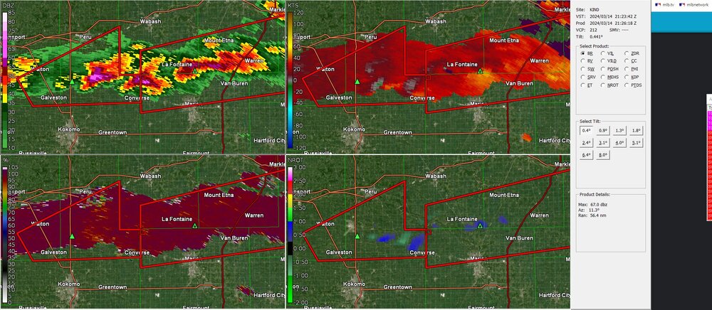
Mesoscale Discussion 0244
   NWS Storm Prediction Center Norman OK
   0656 PM CDT Thu Mar 14 2024

   Areas affected...Southeastern Indiana into portions of
   southwest/south-central Ohio

   Concerning...Tornado Watch 44...

   Valid 142356Z - 150100Z

   The severe weather threat for Tornado Watch 44 continues.

   SUMMARY...An area of greater tornado potential is evident from
   southeast Indiana into southwestern Ohio over the next 1-3 hours.

   DISCUSSION...Three supercells from just east of Indianapolis to
   northwest of Columbus, OH have shown a rightward turn to the
   southeast. Surface flow remains backed in southwestern portions of
   Ohio. Considering the observed storm motion and regional VAD
   profiles, an area of greater tornado threat is evident from
   southeastern Indiana into southwestern Ohio. 850 mb winds are
   expected to increase this evening as well. Should storms remain
   discrete and surface wind backed, the environment would become more
   favorable in the next 1-3 hours.
-
-
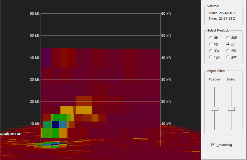
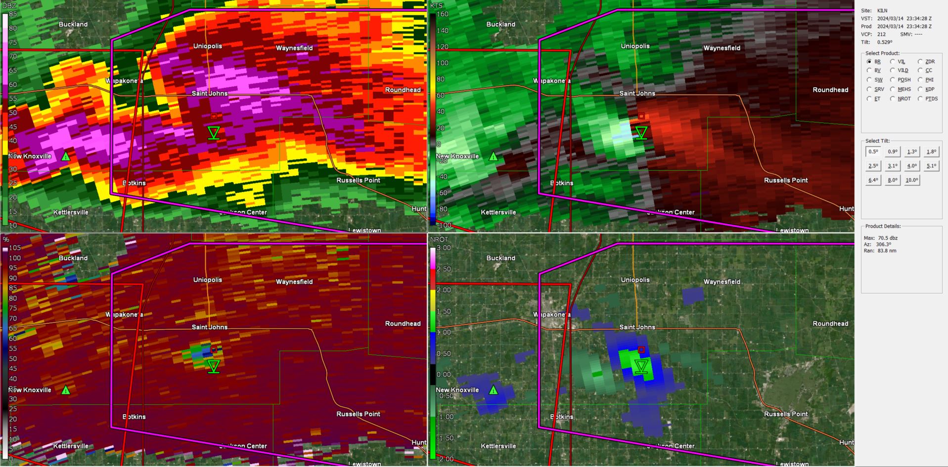
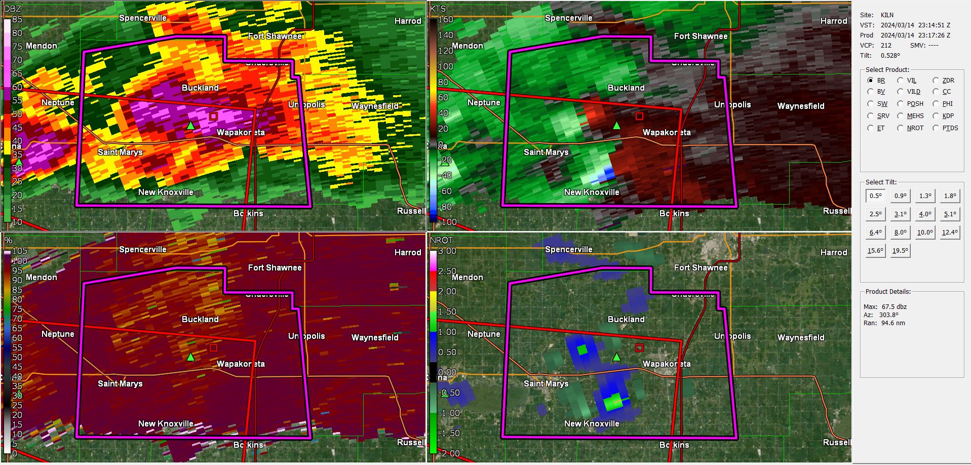
strong tornado ongoing south of Saint Johns, OH

-
-
10 minutes ago, nwohweather said:
Tornado possible in Findlay. I forgot how bad the radar coverage was thereLEO confirmed tor now.
-
already got some spinners north of indy
-
5 minutes ago, WXMan42711 said:
short term guidance has been consistent with the idea of a few discrete cells firing off in S/SE IN after dark. concerning look, given the projected environment at the time and the fact it would be after dark. sun is trying to break thru here and its already 65 degrees, but some possible pop up showers may ultimately temper the threat down here.

-
short term guidance has been consistent with the idea of a few discrete cells firing off in S/SE IN after dark. concerning look, given the projected environment at the time and the fact it would be after dark. sun is trying to break thru here and its already 65 degrees, but some possible pop up showers may ultimately temper the threat down here.
-
eyeing the potential for overperformance here along the ohio river in cincy
-
lots of squalls passing thru the cincy metro this morning. even had thundersnow reported down in northern ky. hopefully gonna get that here with a big squall passing thru shortly
-
 4
4
-
-
cautiously optimistic at the premise of the northern end swiping thru cincy this evening
-
1
-
-
-
Quote
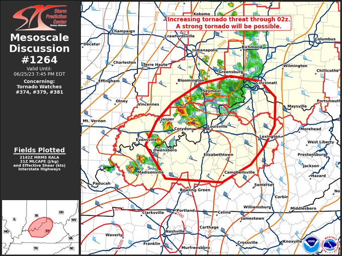
MESOSCALE DISCUSSION 1264
NWS STORM PREDICTION CENTER NORMAN OK
0447 PM CDT SUN JUN 25 2023
AREAS AFFECTED...NORTH-CENTRAL KENTUCKY...SOUTHERN
INDIANA...SOUTHWEST OHIO
CONCERNING...TORNADO WATCH 374...379...381...
VALID 252147Z - 252345Z
THE SEVERE WEATHER THREAT FOR TORNADO WATCH 374, 379, 381 CONTINUES.
SUMMARY...TORNADO RISK WILL LIKELY INCREASE OVER THE NEXT FEW HOURS
WITH SUPERCELLS MOVING EAST ACROSS PORTIONS OF TORNADO WATCHES 374,
379, AND 381.
DISCUSSION...REGIONAL RADAR COMPOSITE AT 2140Z SHOWS SEVERAL
DISCRETE SUPERCELLS FROM EXTREME NORTHWEST KY NORTHEAST INTO
SOUTHERN INDIANA, WITH A HISTORY OF VERY LARGE HAIL. OVER THE NEXT
2 TO 4 HOURS, THE MESOSCALE ENVIRONMENT WILL LIKELY BECOME MORE
CONDUCIVE FOR TORNADO DEVELOPMENT AS LOW-LEVEL WINDS STRENGTHEN IN
ASSOCIATION WITH AN UPPER-LEVEL LOW OVER LAKE MICHIGAN. THE
ENVIRONMENT REMAINS MODERATELY TO STRONGLY UNSTABLE AND WITH AMPLE
DEEP-LAYER SHEAR TO SUPPORT CONTINUED SUPERCELL STRUCTURES.
RAP-BASED STP VALUES OF 6 TO LOCALLY 8 ARE FORECAST IN THE 23Z-02Z
TIME FRAME ACROSS MUCH OF THE DISCUSSION AREA, SUPPORTING AN
INCREASED TORNADO RISK FOR SUPERCELLS REMAINING DISCRETE WHILE
MOVING EAST-SOUTHEAST. GIVEN THIS FAVORABLE ENVIRONMENT, A STRONG
TORNADO WILL BE POSSIBLE.
..BUNTING.. 06/25/2023
-
looks like some parts of the cincy metro could be spared thanks to some developing downpours. whichever model suggested a split was right on the money.
-
completely blue sky here on the ohio river. i hope mother nature is a reds fan
-
-
-
-


indy allowed the warning on this one to expire and replaced it with a special wx statement:
Howard IN-Carroll IN-
618 PM EDT Mon May 8 2023
...A strong thunderstorm will impact portions of east central Carroll and northwestern Howard Counties through 645 PM EDT...
At 617 PM EDT, Doppler radar was tracking a strong thunderstorm producing a landspout 12 miles east of Delphi, or 15 miles south of
Logansport, moving east at 20 mph.
HAZARD...Landspouts, and pea size hail.
SOURCE...Radar indicated. Spotter confirmed landsport at 5:55 EDT west of Flora
IMPACT...Minor damage to outdoor objects is possible. Gusty winds could knock down tree limbs and blow around unsecured objects.
. -
DVN 18z sounding

-
 1
1
-
-
two couplets heading towards stl now. good grief.
-
that peoria storm wants to organize so badly
-
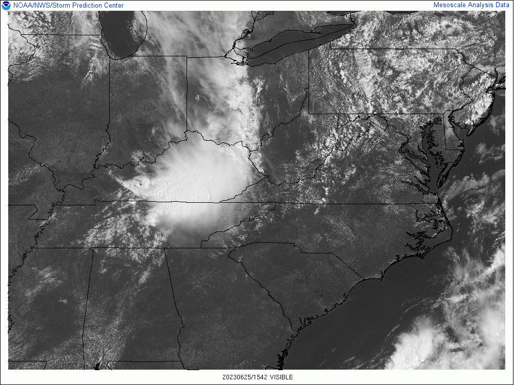
Mesoscale Discussion 0401
   NWS Storm Prediction Center Norman OK
   0236 PM CDT Fri Mar 31 2023

   Areas affected...Central Arkansas

   Concerning...Tornado Watch 94...

   Valid 311936Z - 312000Z

   The severe weather threat for Tornado Watch 94 continues.

   SUMMARY...A confirmed tornado is ongoing within the southwestern
   Little Rock metro area. Downstream environment will remain favorable
   for this tornado to continue.

   DISCUSSION...A tornadic supercell now entering the Little Rock metro
   area has shown increasing organization over the last 30 minutes.  As
   of 223 PM CDT a confirmed tornado was moving northeastward. The KLZK
   VAD shows strong veering in the lowest 1 km (over 400+ SRH). VROT
   was observed to be 74 kts. Given the environment and radar
   signature, this would suggest a likely intense (EF3) tornado.
   Furthermore the low/mid 60s F dewpoints downstream and unimpeded
   inflow, the expectation is for this storm to continue to pose a
   threat for potentially strong tornado over the next hour at least.

   ..Wendt.. 03/31/2023
-
3 minutes ago, weatherextreme said:
tornado on ground, growing very fast.


4/1-4/2 severe threat (southern portion of subforum)
in Lakes/Ohio Valley
Posted
been a long time since this verbiage was used in the IN/KY/OH neck of the woods:
"THE GREATEST RISK, WHICH WILL INCLUDE POTENTIAL FOR A COUPLE OF INTENSE/LONG-TRACK TORNADOES, SHOULD BEGIN ACROSS INDIANA, AND THEN SPREAD ACROSS OHIO THROUGH THE AFTERNOON AND EVENING, POTENTIALLY REACHING AS FAR EAST AS WESTERN PORTIONS OF WEST VIRGINIA AND FAR WESTERN PENNSYLVANIA INTO THE EVENING. EASTWARD ADVANCE OF THE RISK INTO CENTRAL PENNSYLVANIA WILL LIKELY REMAIN LIMITED, BUT OTHERWISE THREAT MAY SPREAD INTO WESTERN PORTIONS OF VIRGINIA AND THE CAROLINAS LATE."