
paulythegun
-
Posts
808 -
Joined
-
Last visited
Content Type
Profiles
Blogs
Forums
American Weather
Media Demo
Store
Gallery
Posts posted by paulythegun
-
-
15 minutes ago, Ravens94 said:
3 camps. Extreme spread still

It's not over yet, but I think this spread is mostly just the surface details of whether a coastal takes over late and pounds interior New England
-
-
-
27 minutes ago, Scraff said:
We celebrate until Dr No arrives.


-
 1
1
-
 8
8
-
-
3 hours ago, psuhoffman said:
I don’t even want to get into this because there are people who live to argue definitions and classifications and I hate that. There are disagreements about exactly what a modoki is. Some classify them as any Nino that originated from the central pac then sometimes propagates east. Others by any event where the warmer waters are centered in the central pac. For our purposes even a basin wide is ok so long as it’s moderate not a super Nino. But we definitely want the warmest anomalies to be in the central pac. There doesn’t seem to be much pattern of regularity. I think there were modoki or modoki like episodes in 1964, 1966, 1970, 1978, 1980, 1987, 1995, 2003, 2005, 2010 and 2015.
3 weren’t great. 1980 was a nightmare where every big storm (there were 3) hit the southern mid Atlantic and north of DC was just cold and dry. 2005 was weak and didn’t couple well and we got kinda unlucky on several storms. But it was a good winter just not great. 1995 sticks out as the WTF went wrong in that group. 1980 and 2005 at least bore characteristics of a modoki Nino and we just got unlucky. 95 was just an anomaly like 1996 was in the other way.
This is how I define Modoki. Anyone who disagrees should be put in an insane asylum.
.gif.4f3e6b24c4af19688bddd112303ccc2b.gif)
-
2
-
7
-
-
Haha there's another wave after the Sunday storm that JUST misses our region:

-
2
-
-
13 minutes ago, Ravens94 said:
Current

That's an old one. Here's the current one, just out:

-
2
-
-
check out the direction of this trend
-
1
-
-
Light rain in downtown DC. 39F.
-
 1
1
-
-
3 minutes ago, losetoa6 said:
Im just an Electrical contractor but this looks real close to a moderate hit around i95.

Rgem
.gif.8da010ac993af53a8f3ef4d500c6bb8b.gif)

-
1
-
-
Miller A had the hat, but this weekend, it's the other one

-
1
-
1
-
-
-
-
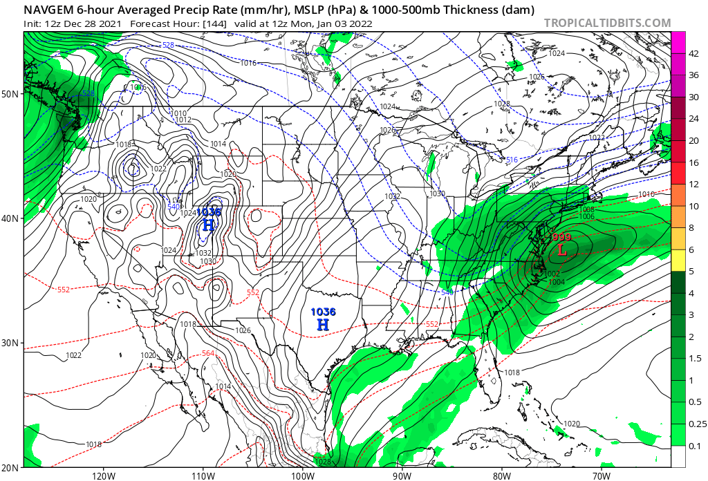
7 minutes ago, Cobalt said:
One of the first cases of me understanding model bias was when I was told that the NAVGEM had an apparent "suppression" bias. This was back in 2017, but in every single instance where an image of the model has been posted, the storm is depicted more AMPED than other guidance. Is this me misremembering, or is this not a continuous occurrence?

NAVGEM was upgraded (NAVGEM 2.0) in 2020. Model resolution improved from 31km to 19km. Not sure what the bias is, but it's a drastically different model.
-
1
-
 3
3
-
-
HIYO!

-
9 hours ago, psuhoffman said:
Pac yes, enso imo not as much anymore because I’m not convinced the pac pattern is driven by enso. It’s been identical for 5 years through 2 ninos, 2 Nina’s, and a neutral year. Hard to argue that is enso driven! Is the pac a problem though regardless of what’s causing it, most definitely yes.
Besides we can’t simply blame the Nina for ruining the -NAO. Nina history says that’s not accurate. Nina -NAO months in Jan Feb and March have actually been snowier then all other enso state -NAO months. Problem is a -NAO is rare in a Nina. This year was more the exception then the rule both in having a -NAO Nina and completely wasting it.
BTW side note: the one exception is obviously moderate to strong Nina’s with a -NAO. That’s the gold standard. Those are when we get crushed with snow. Yes a -NAO still correlated to more snow in other states but if you take weak Nina’s, enso neutral, and Nina’s while a -NAO does favor more snow then normal the numbers aren’t crazy big. And Nina’s actually has better -NAO avg snowfall then neutrals and weak ninos. Small sample size though since there aren’t that many -NAO Nina months.
This made me chuckle:

-
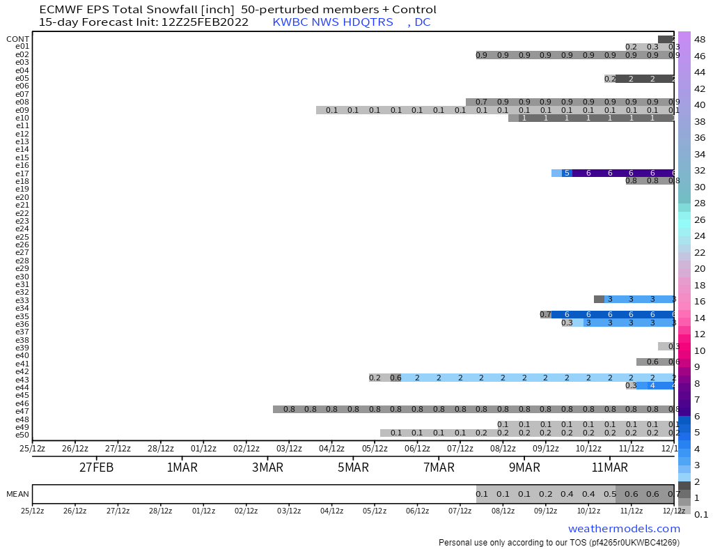
6 out of 30 have decent snow. All centered around day 14-16. Therefore, there is a 20% chance of a massive snowstorm in 15 days. Thank you

-
5
-
 1
1
-
-
LOL. Latest Para-GFS is more suppressed than 12z for next Friday/saturday. Comparison (18z left, 12z right)
Here's how that plays out:

-
Some slight changes at h5. Southern stream wave digs a bit deeper and the northern stream does the opposite:

Weaker storm generally, run to run compared with 00z.
Pressure off the coast, Friday 09z:
- Last night: 1004mb.
- This run: 1012mb.
-
1
-
Para-ECMWF trending in the right direction too.

-
7
-
1
-
-
Why is a person named Blueberryfaygo pretending to be @HotWeatherTake on this forum? I guess it's a wacky bit?
-
1
-
-
6 minutes ago, psuhoffman said:
I remember many many years ago seeing some correlation chart that showed temperature correlations by winter weeks for the major indices. And that I thought oddly the NAO didn’t correlate nearly as much as I expected...UNTIL late January or February then it was like the god of indicators. I’ll have to remind myself of that next time we’re warm during a -NAO early in the season.
Ha that makes total sense. What good is blocking if there's no snowpack in Canada yet?
-
-
NAM looking good
-
2
-
5
-


January 2023 Mid-Long Range Disco
in Mid Atlantic
Posted
I dabbled in pacifism.
....not in NAM, of course.