
ers-wxman1
-
Posts
2,481 -
Joined
-
Last visited
Content Type
Profiles
Blogs
Forums
American Weather
Media Demo
Store
Gallery
Posts posted by ers-wxman1
-
-
7 minutes ago, WEATHER53 said:
Except further south on low and stronger high thwarts that
We don’t have that pattern in place.
-
 1
1
-
-
4 minutes ago, WEATHER53 said:
Mid to upper teens dew points generally don’t give that away in 24-30 hours. Very stout high of 30.40+ the same. If you watch the center it’s been moving toward a path right along VA/NC border. I think we are good for accumulating snow right around DC but 20 miles to east and south more problematic
Strong southeasterly winds off the deck coming off a mild Atlantic will erode that airmass quickly.
-
 1
1
-
 1
1
-
-
1 minute ago, MDScienceTeacher said:
Logically what you are saying makes sense, but we have seen torch to a foot of snow many times before. The writing is on the wall for this and sure its gonna be too warm. But to say we need 3 weeks of pattern change just to get a chance of snow makes me think it is almost impossible for the MA to get a snow storm.
Maybe you are saying this just in the context of this set up.The pattern is missing key features that would generate a solid winter storm not just for the MA but for the Northeast as well. How many arctic intrusions with wind chill headlines and sub zero air masses over the northern Plains and Great Lakes this season. None. Very abnormal to see this over an extended period like we have. Bass boats were being launched on the lakes in Minnesota on 12/27, on a lake where cars normally drive on with thick ice. Something is amiss and yes it would take a larger scale phenomenon to get it to shift.
No mechanisms in place to both drive arctic air in and keep it. Pattern is not amplified like needed. No blocking, no ridging out over the western U.S. we get cool passages with modified air. Not going to get it done. El Niño is only one factor. That just guarantees more southern stream energy, drought going away with ample moisture but it does NOT necessarily mean more snow. No cold air to produce. PSU is correct in his assessment. Going to take a more persistent change or else it’s more of the same.
-
 7
7
-
1
-
-
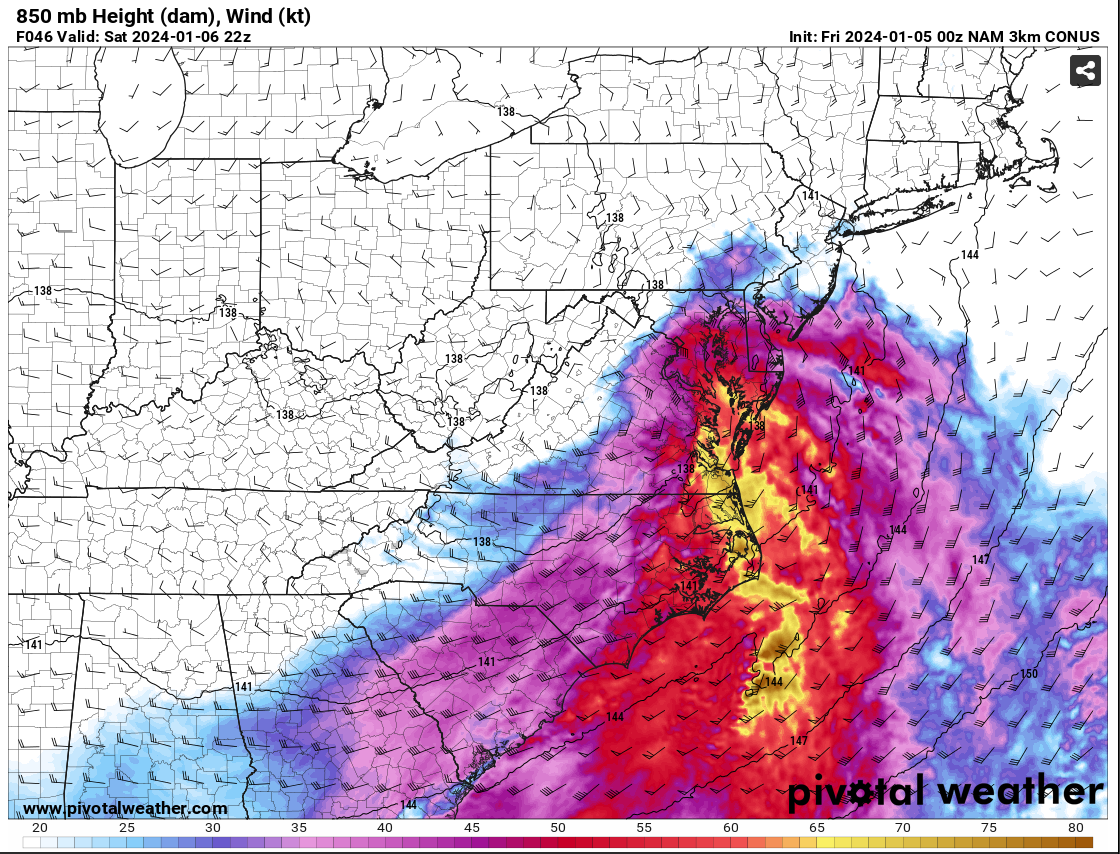
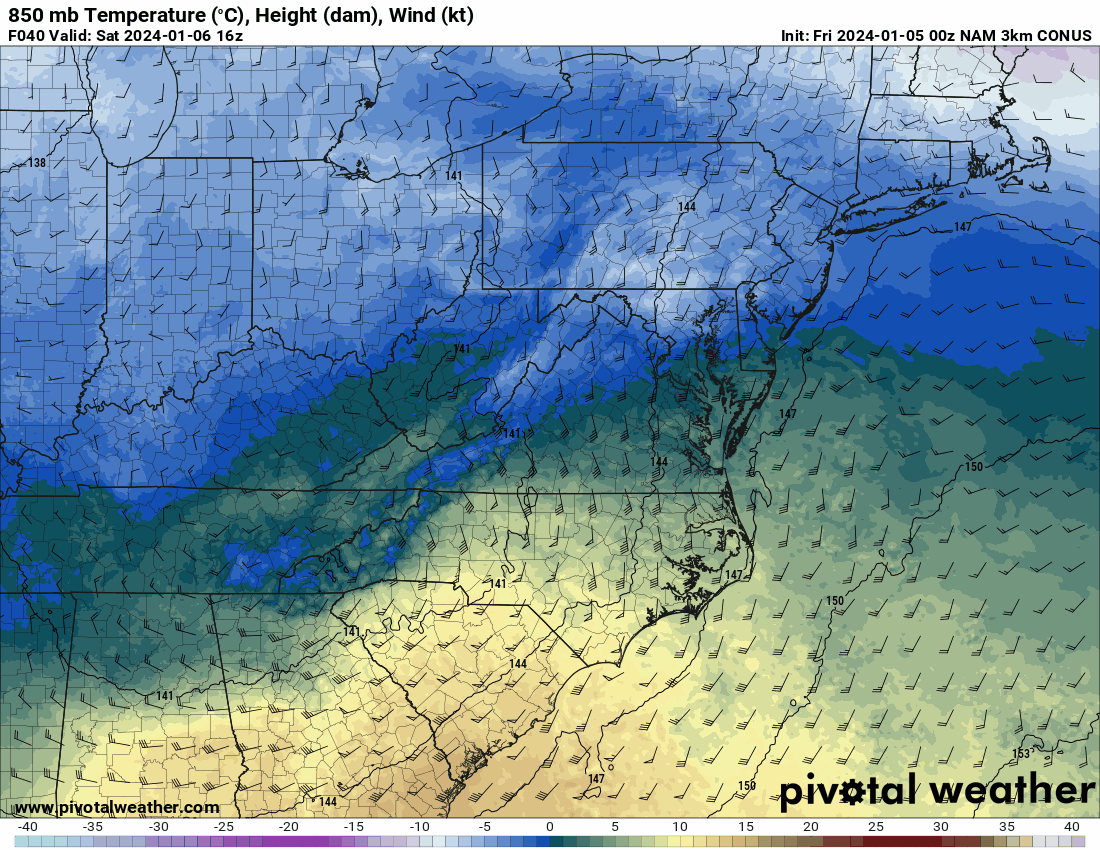
9 minutes ago, MillvilleWx said:
The reasoning for the shift in the colder solution on the NAM is the development of a closed 850mb low tracking south of the Potomac over north-central VA. Pay close attention to the wind barb across the northwest area and how the 850mb southeasterlies hit a brick wall over Parrs Ridge and the wind direction flips. This would allow for cold air to advect into the northern and western side of the circulation creating a more beneficial PBL and keep everything frozen, or even all snow. Check out the wind barbs to the east of RNK...
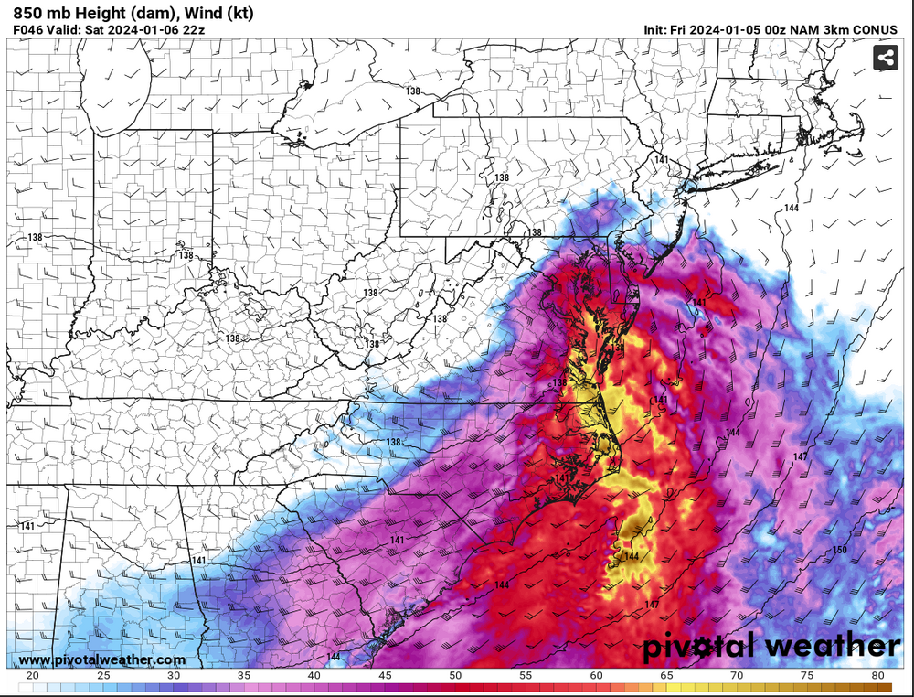
As a result, watch the 850mb temp profile as we work through time. This is actually how you get surprises and periods of heavy snow when you weren't expecting.

MAJOR CAVEAT.... THIS IS JUST ONE RUN OF ONE MODEL!!!
We are going to want to see other guidance pull this off and have it become something to watch. This could be a one run and done deal, but there is potential for this. I will not be committing anything until I see some agreement from other guidance. It was interesting to see and point out as a possibility. It would affect the forecast in a big way. These are why these marginal events are so tricky. One thing can make or break a forecast. Let's hope it's right. Right now, no changes from my current thinking.
Guidance did this on the Wed 00Z run, closed off the 850 low tracking to our south and frozen went up dramatically.
-
9
-
1
-
-
16 minutes ago, EastCoast NPZ said:
Goodness, this thing has trended the wrong way. Has anyone ever seen a major storm consensus on all guidance at D5 degrade like this? I know they've busted at gametime, but to see this storm universally morph on guidance in the medium range like this?
Wrote about this yesterday. It is a mistake just to look at the model output, QPF etc. Analyze the scenario from the top down. 500/700/850. Are you seeing any features that align with known weather patterns that generate heavy snow across our area? Ridging out west, 850/700/500 energy is closed, deepening as it swings to our south? Strong high to the north? Blocking? Also with the CAD…what kind of air mass is being dammed? Nowhere in the northern tier do we see wind chill or extreme temperature headlines. These are flags. It’s been mild.
The big difference last night on the 00z I saw was the 850 low became closed and stronger with the vort passage, while the high became stronger, and more dynamics, ridging hinted over the western U.S. that amplifies things enough to deepen the surface low in the right spot, however this isn’t slam dunk. It’s all marginal and not dealing with a textbook winter storm here, so any minor shift in these subtle features will significantly alter snowfall amounts. That is what is happening. It’s simply not the ideal pattern. It would be a heavy front end thump then hope for wrap around as it winds up offshore before subsidence kicks in. Many moving parts. Strong SW upper flow makes this fast moving system, rely on front end WAA. Thermals also marginal, no good source to fuel this. These types of systems are a nightmare to forecast, especially with regard to headlines and where to put them.
-
14
-
1
-
2
-
-
22 minutes ago, snowfan said:
Speaking strictly of temps….the air mass has been marginal on guidance for some time.
There has never been anything in place to support such a storm. Guidance in the long range is simply trending toward climatology. The features that were being modeled weren’t even in the U.S. It gets closer then reality settles in. There is not a single cold temperature or wind chill headline out anywhere in the Plains or New England. That is very telling of the airmass we are dealing with. Bass boats were going out on the lakes in MN late Dec where normally you would find cars driving out on the ice. Different patterns driving weather. It’s important to know the patterns, analogs, so you know the type of setup that is textbook to this area. If a model is dumping double digit snows here but doesn’t align to a pattern known to produce then you have a red flag right off the bat.
-
1
-
1
-
-
2 minutes ago, SnowDreamer said:
Brutal. DCA gets a dusting and Leesburg gets a foot.
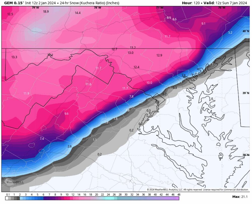
12” totals will be over the higher terrain for this event. CMC likely overdone, even into the far NW suburbs. Model doesn’t account for temps effectively. It could be 36F and snow with no accumulation efficiency, but the model still adds up the total snow in general ratio. Essential to analyze the pattern unfolding and projected vs the dump of snow in the more amplified solutions. What in this pattern would actually drive double digit accumulations? You’ll be hard pressed to find the features.
-
2
-
4
-
1
-
-
The warmer, less amplified solutions are likely trending toward the proper setup for this pattern. Not to say the area won’t see a slug of moisture, likely will, but BL won’t be supportive even in the immediate suburbs.
-
1
-
-
This is not the pattern setup you want for significant snowfall in the MA. 500mb pattern is progressive, lack of ridging over the west and weak high to the north retreats with airmass not overly cold. “ Cold airmass” in place will not be cold enough for most areas east of the mountains. Need upper energy to be deepening to our south, GFS coming more into reality now with the progressive weaker system.
-
4
-
1
-
1
-
-
Just now, MillvilleWx said:
I need to go to Spain so bad. I know someone who lives in Barcelona and they said they would house us if we came over. Might have to take advantage of that!!
All depends what you are interested in. Sagrada Familia if you go to Barcelona.
-
1
-
-
2 minutes ago, MillvilleWx said:
It’s wild. And parsing ICON data is wild to me. That model is terrible.
Digital snow wars have begun. Move em to banter.
-
1
-
-
22 minutes ago, pazzo83 said:
Spain is awesome - Madrid, Sevilla, Barcelona, the southern coast. Haven't been to northern Spain yet but that's next.
San Sebastián is amazing. Stay near the beach.
-
2
-
-
A good day to all. Making my first post in quite some time. The media, backyard meteorologists, and even some private sector Mets got sucked into the mentality of “ It’s El Niño” we will get clobbered. Yes, there have been records of strong El Niño years producing a record snow/storm, but our climate whether you believe it or not is changing. It’s been 8 years since we’ve seen an 18”+ event. Everyone sees El Niño and out flies the coop on 30-40” snowfall for the area, big snows. Only problem is…where is the cold air? There is none, it’s locked way up and not coming down anytime soon. Don’t believe me? It’s mid December. How many wind chill warnings or sub zero airmasses have come down into the northern Plains this season? About none so far. El Niño is only one factor in a giant puzzle. The inexperienced look at one or two factors then run with it. This will be a warm and wet winter for most on this sub forum, even the I-81 corridor. We will see one shot at a big storm but with typical I-95 temp issues and accumulations N and W of 95. Couple smaller events here and there and that will be it for the 23/24 season. Very disappointing. Local ski resorts minus Snowshoe will be hurting this year. There is simply nothing in place to lock in cold air, and what is available isn’t even cold. I expect the drought to be over by March. There will be so much rain over the next three months that the word drought won’t be around for a while.
-
6
-
1
-
-
2 minutes ago, Always in Zugzwang said:
Whatever can generate clicks, in this age, I suppose. Sadly, that's what it's all about so often...apologies for my cynicism. It's not just weather either...that extends to news as well.
It’s everything nowadays.
-
1
-
-
1 minute ago, Always in Zugzwang said:
Yup, those are some good winter seasons to remember! One thing I've found interesting, and this could just be total chance and luck, is how March has tended to be a month that gives us a decent event and one last cold blast before spring settles in. More so in the last decade, it seems. I don't know what that means, if anything, and it is anecdotal to be sure. But just ticking off years that I can immediately call to mind that had some kind of March snow/wintry event include 2009, 2013, 2014, 2015, 2017, 2018, 2022. I may have missed a year in there, too. They weren't huge storms or anything like that but there was some legit cold and a few inches (2009. 2014, 2015 did have solid warning events in March).
March is the change of seasons, change of the jet stream, clashing air masses. Almost always get something of interest in March. Our issue is cold air.
-
1
-
-
5 minutes ago, psuhoffman said:
The usual suspects on Twitter. And some get overly excited by every model run that shows digital blue. Then get mad when reality sets in.
These guys are an embarrassment to all meteorologists out there. They give all the rest of us a bad look. Trying to hit a home run to drive publicity. I end up putting out fires over bad information often, and it is difficult to walk back once it’s out there.
-
2
-
-
7 minutes ago, Always in Zugzwang said:
Thanks for this. It's disappointing, to be sure, for anyone who is a snow lover (myself included). But what the hell can one do? You don't have control over what does or doesn't fall from the sky, but you DO have control over how you react and deal with that. I won't pretend that I'm not disappointed or feel frustrated. But there are many other things I can do and have been doing, weather be damned. It shouldn't run one's life. I still take photos (the sky the other evening was simply amazing at sunset!) which I truly enjoy doing, go for walks, and if I can get back in the right mood for it (since moving a couple months ago), will get on the bike and ride again for a bit.
My only hope, I guess, is that we don't have mosquitos or other annoying bugs start showing up while it's still technically winter!

Honestly I just wrapped up 3.5 months of Florida weather support for Ian and Nicole, both on-site and remote support. I’ve seen enough carnage for a while and if the R & R comes in the form of a quiet winter I’m not going to balk… lol. I used to go into F5 aggravation over lack of snow but putting things into perspective after a few significant life events and working the Florida incident have honed things in for me.
-
4
-
-
Just now, psuhoffman said:
Here’s how bad it’s been the last 7 years…DCA could avg 27” the next 3 seasons and it would still end the 10 year period below avg. A 30 year avg already pathetically lower than previous historical periods!!!
Impressive stats! We had those incredible seasons… 09/10, 13/14, 15/16 and a couple in between years after, now the drought. Usually see an 18”+ event in the area every 5 years or so but now 7 years and counting. Not just snow, we haven’t had a meaningful tropical system since Irene in 11 and Sandy in 12, derecho in 12. Void of exciting weather for more than 10 years. At some point whether it’s winter, severe, or tropical we will have a big event, pattern won’t be like this forever.
-
4
-
1
-
-
6 minutes ago, SnowenOutThere said:
I understand these posts upset you but some of here like to be realistically informed about if it will snow, that is why it is always appreciated when @psuhoffman posts IMO. It’s better than Mets who just hype up storms when it’s far more likely they fail.
Who is doing the hype? Lol nothing to hype about.
-
1 minute ago, psuhoffman said:
And we’re experts in not looking good
It is pretty crazy to have such a drought all the way north into New England like this. Even upslope events have been sparse.
-
1 minute ago, TSSN+ said:
Glad I went to Hamburg for the lake effect event. Least I got to enjoy something.
That’s about the amount of snow we’ll see here for the next 10 years + lol.
-
 1
1
-
-
Just now, psuhoffman said:
Oh no you said it. He might be jumping off a building right now.
Ive posted the data to back this up. Years that started like this one didn’t end well 99% of the time. But I’ve been too timid to flat out say it. But I feel it.
It is not looking good at all.
-
14 minutes ago, Maestrobjwa said:
Listen KNOWING it's bad doesn't make the pain go away, dude. I'm not sure you understand what if feels like. For some of us the present reality is not what we came up with like at at all. This problem is potentially bigger than now...but the FUTURE. It's not just bad now, but talkin' worse in the future. That part is NEW. Before ya had duds then hits, not 7 straight duds with no guarantee it breaks. That's pain, dude, and it's a tough pill to swallow this new reality.
You do realize this is snow right? Frozen crystals that fall from the sky. A life significance factor of 0.001 out of 10, and most of the depression is over digital snow. The Mid Atlantic region is in a prolonged snow drought. There is nothing in place now or in the near future to shift this pattern. If you want to find meaningful snow head to the west coast, Rockies or northern Plains. Wouldn’t be surprised to see a complete shutout for our region this season. Even snowshoe is paltry. Skiing is some of the worst I’ve seen in years. It’s not just us, much of the MA to New England is hurting. But seriously, find joy in other areas.
-
3
-
5
-
-
Ashburn Village: 39F. Sleet and rain.
-
6
-

January 6-7 Storm Discussion: we’re due?
in Mid Atlantic
Posted
24/17 here in Snowshoe, WV. First weekend of skiing.