
Chinook
-
Posts
9,583 -
Joined
-
Last visited
Content Type
Profiles
Blogs
Forums
American Weather
Media Demo
Store
Gallery
Posts posted by Chinook
-
-
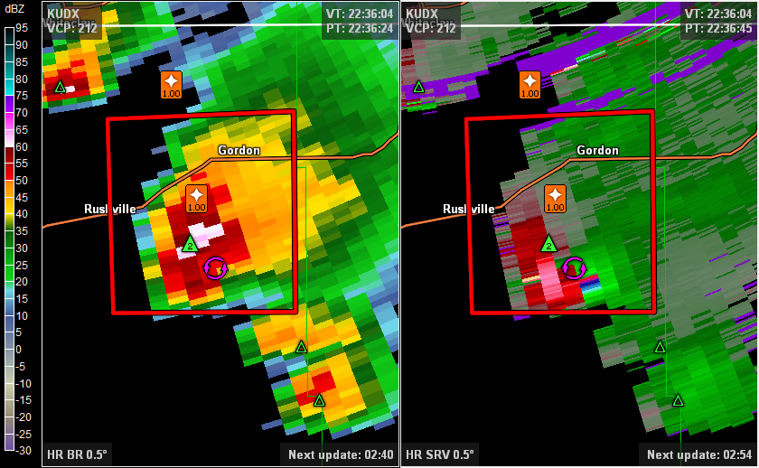
decently strong mesocyclone at Rushville/Gordon Nebraska (Sheridan County). Perhaps a tornado warning will be soon.
-
June 27th may have been one of the most active tornado days of the year, with tornadoes in Virginia, Maryland, North Carolina, Minnesota, South Dakota, and North Dakota. SPC unfiltered reports for this day show 48 tornado reports. Several tornadoes occurred in North Dakota. I believe there were 20 tornadoes in the Grand Forks CWA alone, based on these storm report lists/storm survey reports:
http://kamala.cod.edu/nd/latest.nwus53.KFGF.html
http://kamala.cod.edu/offs/KFGF/1507020315.nous43.html
--
NWS Grand Forks
--
PUBLIC INFORMATION STATEMENT NATIONAL WEATHER SERVICE GRAND FORKS ND 1015 PM CDT WED JUL 1 2015 ..NWS DAMAGE SURVEY FOR 06/27/15 TORNADO OUTBREAK ..THREE ADDITIONAL TORNADOES HAVE BEEN IDENTIFIED AND SURVEYED
OVERVIEW NUMEROUS TORNADOES WERE SPAWNED DURING AN OUTBREAK WHICH INITIATED IN SOUTHERN MANITOBA AND MOVED SOUTHWARD THROUGH THE EASTERN DAKOTAS AND WESTERN MINNESOTA. MORE THAN A DOZEN TORNADOES HAVE BEEN IDENTIFIED WITH THIS OUTBREAK IN EASTERN NORTH DAKOTA...WITH ADDITIONAL TORNADOES HAVING POSSIBLY OCCURRED ADJACENT COUNTIES IN MINNESOTA AS WELL.
-
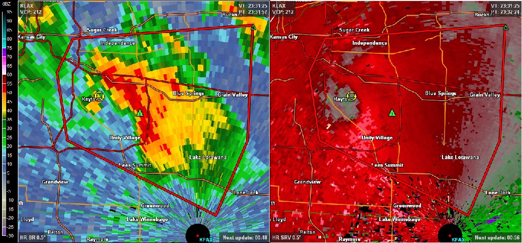
tornado reported at Raytown at the time of this image
-
Seeing some intriguing forecast soundings from both the NAM and GFS for southeastern Kansas into west-central Missouri tomorrow. Ongoing convection is one of the biggest issues, although if some storms can develop on the southwestern flank of that action, they'll be tapping into a forecast environment that is very supportive of severe thunderstorms. Looking closer, it appears that the models want to develop a small area of low pressure near the KS/MO border. Another convoluted setup that has many issues, but nonetheless, SPC did introduce a SLGT risk area in the 1730 Day 2 outlook.
Right now: tornado watch has been issued in the radar-hole-land of west ND, east MT.
Tomorrow, I agree with you. The area from Kansas City to the MO/AR border should see several thunderstorms. I think there will be some severe wx in this area, and also some areas of elevated T-storms that are sub-severe.
NAM 84-hr rain totals show pretty high rain amounts, most of Missouri, to Memphis and Paducah.
-
NWS 4-km precipitation analysis available here (for free) http://models.weatherbell.com/hrap/nws_precip.php shows that Toledo has had 9-11 inches of rain in 30 days (as of a couple of days ago) and Cleveland has had 9-13 inches. That's huge!
-
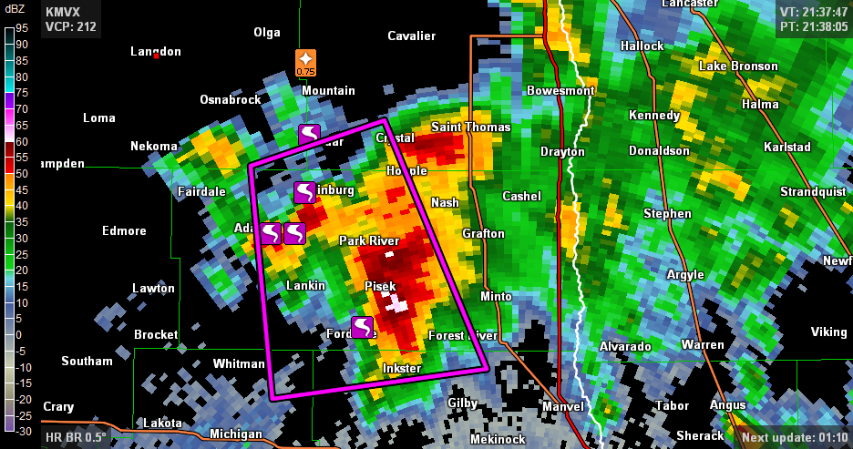
A tornado has been reported at Gardar, ND. The storm cell was kind of a mess. The storm dropped almost straight south out of Canada. You don't see too many tornadic storms dropping out of Canada.
Edit:
swarm of tornadoes in northeastern North Dakota
-
HRRR is advertising a relatively long squall line in TX and OK.
-
Several storms are developing in the tornado watch area now. They all seem fairly ordinary, though.
-
4.51" in an hour at Corpus Christi Airport.
-
NWS Norman tweeted this about Oklahoma City:
May 2015 may set the record for the wettest month since records began in late 1890. Already at # 5.
-
Nebraska and Kansas are about 1/2 filled with light rain. It's just amazing how many rain events have happened on the plains. Maybe we could even get rid of some of the drought in Minnesota.
-
tornado reported on a second supercell that has tracked southeast of Hallam/Princeton Nebraska
-
Wenesday could be pretty active, as a shortwave will kick out from the southwest into the Plains from Tuesday to Wednesday. The NAM and GFS show plenty of rain in the southern Plains on Wednesday, perhaps meaning that broad-scale convection could hurt chances of destabilization.
-
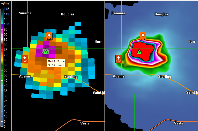
hail size and VIL are large (3.52" and 127 kg/m2) on this storm south of Lincoln Nebraska
-
Yesterday's long-range GFS came up with a fantasy storm for mid-Lake Erie to Windsor ONT. Today, fantasy for CLE-BUF.
-
NWS point&click and MEX-MOS has 4 out the next 5 mornings at or below 0 for Toledo area. The average low for these days is 23!
-
Toledo is just 0.7" away from tying the record snowiest February. (25.2" and 25.1" are the top 2, separated by 111 years)
-
A few wind gusts in northwest Ohio have reached 48-49mph. It must be very annoying and dangerous, for the people out there who might be more likely to get frostbite.
-
Toledo had a light glaze tonight, then some sleet, then some snow. Unknown Precipitation "UP" in the ASOS reports is frequently sleet (although I have no idea why)
KTDZ 090016Z AUTO 03010G17KT 3SM FZRA BR OVC005 00/M02 A2981 RMK AO2 UPB12E13FZRAB13 P0000 I1001 T00001017 TSNO
KTDZ 090353Z AUTO 03011G18KT 3SM -SN BR OVC009 M02/M04 A2989 RMK AO2 SNB26 CIG 006V013 SLP125 P0001 T10221044 TSNO
TOL
KTOL 090352Z 04010KT 8SM FEW007 OVC016 M02/M03 A2988 RMK AO2 UPE02B49E51FZRAB02E13SNB13E49 SLP124 P0003 T10221033
-
Toledo area storm totals.
CoCoRAHS shows 11-14" in the Toledo area, 9-12.5" in Henry County Ohio, 15.3" in Monroe County MI, 8" in Sandusky County OH.
Edit: 12" of snow at Toledo Express.
NWS public information statements/LSRS
..LUCAS COUNTY TOLEDO/OREGON 9.0 921 PM 2/01 SNOW SPOTTER TOLEDO-PT PLACE 8.4 913 PM 2/01 SNOW SPOTTER TOLEDO EXPRESS AIRPO 8.3 900 PM 2/01 ASOS 5 WNW PERRYSBURG 7.0 600 PM 2/01 PUBLIC TOLEDO 6.3 830 PM 2/01 SNOW SPOTTER
0835 AM SNOW NAPOLEON 41.40N 84.13W 02/02/2015 M8.4 INCH HENRY OH COCORAHS
0932 PM HEAVY SNOW 9 NW WAUSEON 41.64N 84.26W 02/01/2015 M14.3 INCH FULTON OH PUBLIC STORM TOTAL.
Michigan
..MONROE COUNTY MONROE M 14.0 28 41.92N 83.39W 3 SW MONROE M 15.0 30 41.89N 83.43W
-
My brother just asked me what they will get in Canton. Wow. Hard call. I think some rain will happen in the middle of the storm, if any rain.
-
I see freezing rain/sleet at CAK and freezing rain at AKR, and spotter reports of freezing rain from Canton/Akron to Pittsburgh.
-
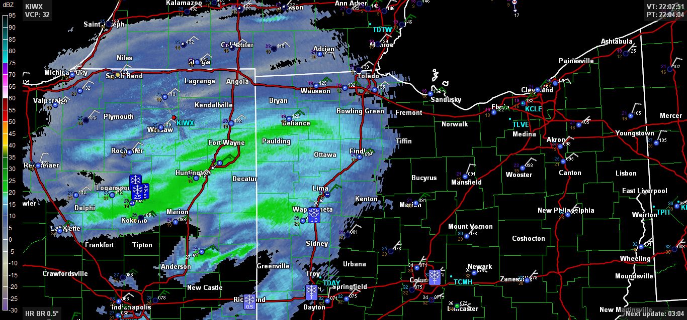
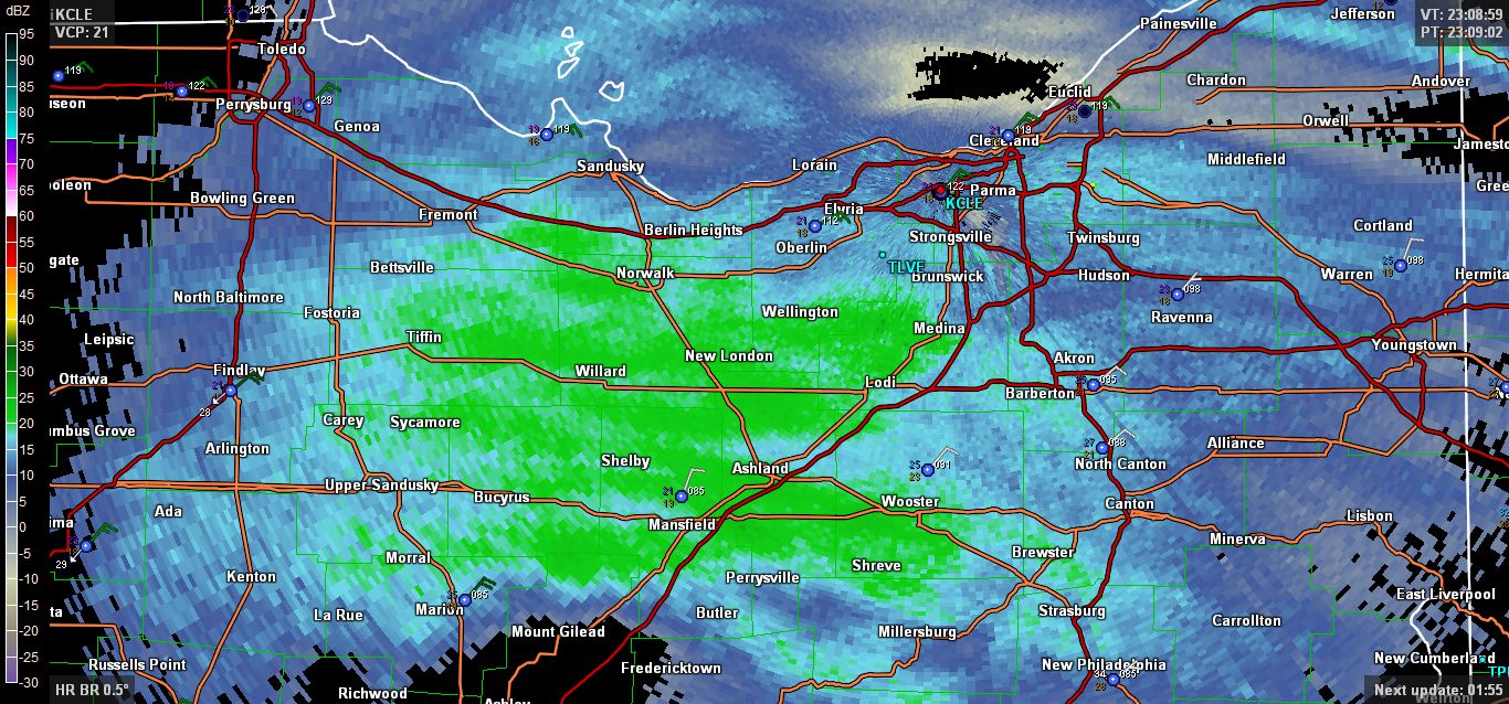
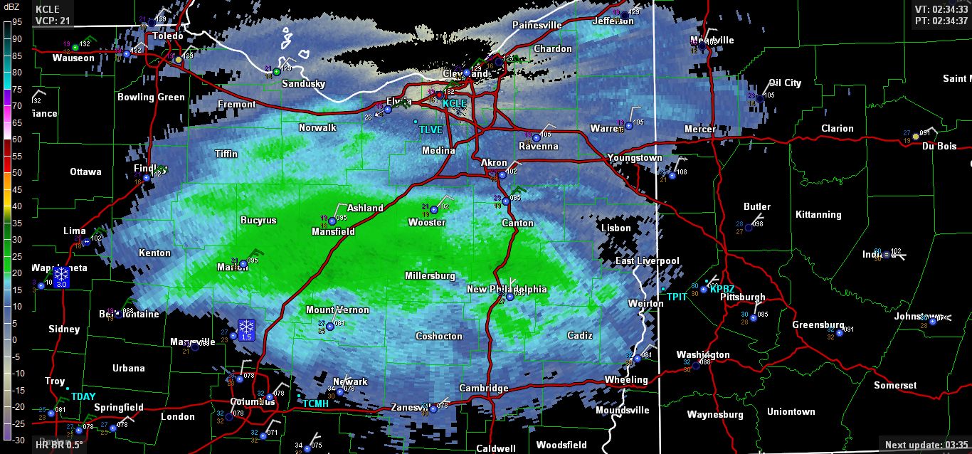
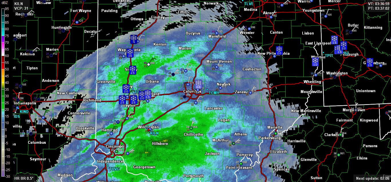
A few radar images of OH/IN from yesterday/last night
-
Well, PCW airport ASOS has reported some slightly weird things since it came online (less than a year ago?). Maybe that -14 temperature wasn't one of the weird ones. I don't remember this ASOS being there before 2014.
Short-Term Severe/Flooding Discussion
in Central/Western States
Posted
possible tornado(es), 91mph wind gust, 80mph wind gust, golf ball size hail in NW Nebraska from that cell.