
andrew29649
-
Posts
26 -
Joined
-
Last visited
Content Type
Profiles
Blogs
Forums
American Weather
Media Demo
Store
Gallery
Everything posted by andrew29649
-

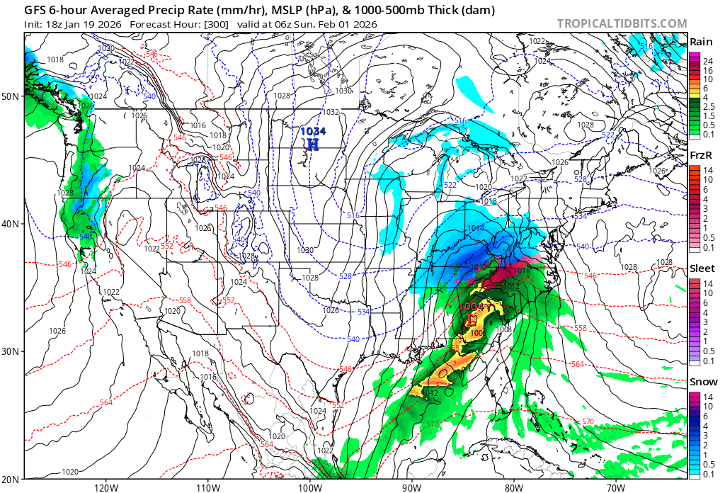
The “I bring the mojo” Jan 30-Feb 1 potential winter storm
andrew29649 replied to lilj4425's topic in Southeastern States
Can you get that in the Kuchera ? -
The “I bring the mojo” Jan 30-Feb 1 potential winter storm
andrew29649 replied to lilj4425's topic in Southeastern States
Reach! That would be an earlier than expected onset for the southern upstate of SC -
The “I bring the mojo” Jan 30-Feb 1 potential winter storm
andrew29649 replied to lilj4425's topic in Southeastern States
You have a great point. My vague memory always remembers them starting around dusk or in the early AM hours. Waking up to way more than forecast. Every one I can remember during the day was a temperature battle that cut totals. -
The “I bring the mojo” Jan 30-Feb 1 potential winter storm
andrew29649 replied to lilj4425's topic in Southeastern States
Someone cash me out now please! Never seen a 3 day away Euro map show ~12” for MBY! What a wild winter! -
The “I bring the mojo” Jan 30-Feb 1 potential winter storm
andrew29649 replied to lilj4425's topic in Southeastern States
That same thought came to mind. The tv mets are tired and probably over fatigued from comments calling it a “bust” they will be even more conservative. -
The “I bring the mojo” Jan 30-Feb 1 potential winter storm
andrew29649 replied to lilj4425's topic in Southeastern States
The ratios being high give us all some life. 0.40-0.60 QPF at 15:1 would be nice! -
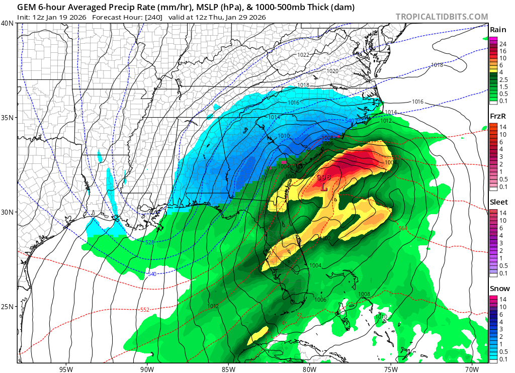
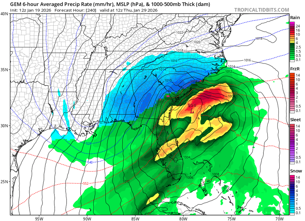
Southern Crippler - Get well soon Jimbo Storm Obs
andrew29649 replied to BooneWX's topic in Southeastern States
IMO the CAD won. We never went above freezing in the southern part of upstate SC. -
Southern Crippler - Get well soon Jimbo Storm Obs
andrew29649 replied to BooneWX's topic in Southeastern States
Comes from getting an ultimate WEDGEy -
I say wait until it’s snowing in northern Mississippi next Friday first
-
https://www.facebook.com/share/v/1B8YyNq9AP/?mibextid=wwXIfr Verbatim: Don’t doubt the wedge. Low pressure tends to take the path of least resistance. High pressure is locked in, the Low isn’t going to plow into it. Expect a slight southward trend on the models coming up.
-
Considering there would be QPF equivalent of frozen precip of at least 1” would that not help hold surface temps below freezing in the areas that show the CAD eroding? Said differently, do the models take into account snow, ZR, IP on the ground when modeling 2M temps? I would think there would be an insulating factor here…
-
GWD is MBY As I watch the trends this forecast seems inevitable. Need to find an ice storm preparedness checklist now.
-
Has there ever been a Z rain event that widespread in the south/southeast ever? I just don’t want to believe that can verify.
-
The GFS is picking up on something similar roughly 2 days later. It’s really amped up too soon and cuts up the apps.

-
CMC is working on some gravy on top of the taters after this weekend
-
FWIW the Canadian does too
-
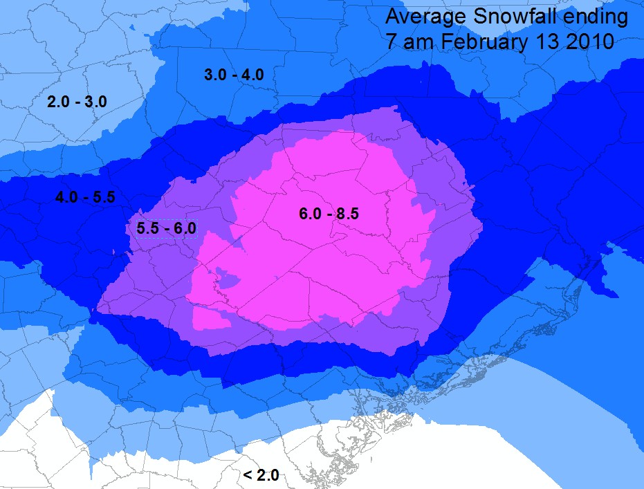
The last time I can remember a clown map giving us 12”+ within 5 days of onset we ended up with about 8” packed by a layer of sleet and ice on top, locally. That was February 12/13th 2010. The Snow stayed around for days. In spots where it had been piled up from the plows, weeks. All of the model guidance was not in agreement so local mets didn’t really sound the alarm until a day or two before.
-
I’ve been lurking for almost 20 years. This is crazy to me less than a week out. Considering all globals seem to be showing something of WSW criteria at the same time.
-
I’m not greedy, let’s just cash out right now!
-
Someone should just jump the gun now and make a storm thread for this weekend Let’s just go ahead and be super confident that it’s happening!
-
We are back!!
-
Just over here hugging NAM snow maps and discrediting the Euro as usual. Getting primed up for a let down IMBY
-
Southern Upstate SC: “Check Please!” I’ve been at my place for 10 years and have yet to see any decently measurable snow since I’ve been here. We are due!
-
IMO the rain snow line on radar is progressing faster southeast in GA, AL, MS, LA, and TX. The whole gulf coast of TX is in SN and that's not something I would have expected based on previous forecast. It seems as heavier precip moves in, those areas are having no issues changing over to SN. Hopefully the RN/SN line continues this same progression as the precip and sunrise occur in SC and NC.
-
I'm sold on this event. Temps and moisture should work out at some point. As far as hazardous impact outside of the mountains, that I'm not sold on. It's going to be nice to see a few flakes fly and maybe enough to make some snow balls in a few areas around I85.