

canderson
-
Posts
21,580 -
Joined
-
Last visited
Content Type
Profiles
Blogs
Forums
American Weather
Media Demo
Store
Gallery
Posts posted by canderson
-
-
WPC Target again for 2-4” additional today
Mesoscale Precipitation Discussion 0531
NWS Weather Prediction Center College Park MD
1245 PM EDT Tue Jul 24 2018

Areas affected...Northern Maryland/Delaware into central
Pennsylvania, far western New Jersey and southern New York

Concerning...Heavy rainfall...Flash flooding likely

Valid 241643Z - 242130Z

SUMMARY...Flooding and flash flooding appear likely over the next
3-5 hours from northern Maryland/Delaware into portions of central
Pennsylvania, western New Jersey and southern New York. An
additional 2-4 inches of rain with rainfall rates of 1-2 in/hr
through 21Z can be expected.

DISCUSSION...Regional radar imagery at 16Z showed a NNW-SSE axis
of heavier rainfall in the vicinity of the northern Chesapeake Bay
with rainfall rates of ~1 inch in 15-20 minutes per
Wunderground.com observations. The broken line of heavy rain was
coincident with weak low level confluence beneath locally
diffluent flow aloft given the presence of a narrow upper level
ridge axis along the East Coast. The line has been gradually
shifting to the north and east which has prevented potentially
much higher rainfall totals over the past 2-3 hours but the
northern Mid-Atlantic region is saturated from a widespread 4-10
inches of rain which has fallen over the past few days.

CAPE values across the northern Mid-Atlantic into southern New
York are generally less than 1000 J/kg given cloud cover, but
given the moist environment, higher CAPE values are not needed to
support heavy rainfall rates. Nonetheless, clearing over eastern
Pennsylvania may allow for increasing instability through the
afternoon along with the development of new convection. Little
change to the synoptic environment is expected over the next
several hours which will keep precipitable water values over 2.25
inches and 30-40 kt 850 mb flow from the south helping to support
repeating and brief training of heavy rain cores. Given the
antecedent conditions, flooding and flash flooding are considered
likely.
https://www.wpc.ncep.noaa.gov/metwatch/metwatch_mpd_multi.php?md=0531&yr=2018
-
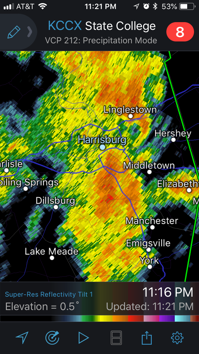
Nothing out yet from CTP but HBG fire officials are concerned about the Susky hitting 22' or so and not the 18' currently forecast.
For those unfamiliar, that difference makes a massive difference in the problems it causes. At 18' it's fairly minor basement flooding and City Island parking lot flooding. At 21.5' it breaches the banks in Shipoke and near the Governor's Mansion.
-
New warning just terrified my office as all phones went off at once.
lash Flood Warning
PAC041-043-071-133-241745-
/O.NEW.KCTP.FF.W.0023.180724T1454Z-180724T1745Z/
/00000.0.ER.000000T0000Z.000000T0000Z.000000T0000Z.OO/

BULLETIN - EAS ACTIVATION REQUESTED
Flash Flood Warning
National Weather Service State College PA
1054 AM EDT TUE JUL 24 2018

The National Weather Service in State College PA has issued a

* Flash Flood Warning for...
  West central Lancaster County in south central Pennsylvania...
  York County in south central Pennsylvania...
  Southern Dauphin County in south central Pennsylvania...
  Northeastern Cumberland County in south central Pennsylvania...

* Until 145 PM EDT..

* At 1045 AM EDT, Doppler radar indicated an area of heavy rain
  moving into the warned area. Up to eight inches of rain has
  already fallen in this region over the past few days, with
  flooding ongoing in many locations. An additional 1 to 3 inches of
  rainfall is likely by early afternoon. This will increase
  the severity of the flooding.

* Some locations that will experience flooding include...
  Harrisburg, York, Lower Allen, Hanover, Hershey, Colonial Park,
  Weigelstown, Elizabethtown, Progress, Mechanicsburg, Middletown,
  Camp Hill, Palmyra, New Cumberland, Parkville, Red Lion,
  Linglestown, Enola, Steelton and Spry.

The Codorus Creek is already above flood stage, and this will
exacerbate flooding problems along the creek. Additional rapid rises
on the Conowingo and Little Conowingo Creek are also expected.
-
I'm now beginning to worry a bit about the river, though the lack of heavy rain in the northern mountains probably saves us.
-
21 minutes ago, sauss06 said:
Bad.
That’s terrible - was hoping just a kitchen issue.
-
5 minutes ago, sauss06 said:
reason for my 2 hours of sleep.
Currently heavy rain in Da Burg
How bad is it?
-
1.5” from 12-1 am apparently. No clue otherwise.
Its really bad around here.
-
12 minutes ago, TheDreamTraveler said:
Yeah this is really starting to remind me of the September 2011 flooding. Do any of you think this will get close to the top 3 worst flooding for our area? I know the 2011 flooding was the 3rd worst ever.
The Susquehanna is not going to come anywhere near 2011 numbers. 2011 featured Irene then Lee - something like 18” rain in a week.
-
This is up there with the hardest rain I’ve seen since moving here. My 5” rain gauge is gone, guess it filled and fell over.
-
 1
1
-
-
Annnd incoming

-
Rough night here x flooded out city roads, Dockside Willies on fire, and a woman in Lancaster County swept away in flood waters apparently.
-
On cue, it’s f’n pooooouring rain.
-
Flash flood warning for southern tier:
BULLETIN - EAS ACTIVATION REQUESTED
Flash Flood Warning
National Weather Service State College PA
1004 PM EDT MON JUL 23 2018

The National Weather Service in State College PA has issued a

* Flash Flood Warning for...
  West central Lancaster County in south central Pennsylvania...
  Adams County in south central Pennsylvania...
  Southwestern Northumberland County in central Pennsylvania...
  York County in south central Pennsylvania...
  Dauphin County in south central Pennsylvania...
  Northeastern Juniata County in central Pennsylvania...
  Perry County in south central Pennsylvania...
  Eastern Cumberland County in south central Pennsylvania...

* Until 300 AM EDT..

* At 1003 PM EDT, Doppler radar indicated heavy rain approaching
  the warned area. Flash flooding is expected to begin shortly.

* Some locations that may experience flooding include...
  Harrisburg, York, Carlisle, Lower Allen, Hanover, Hershey, Colonial
  Park, Weigelstown, Elizabethtown, Progress, Mechanicsburg,
  Middletown, Camp Hill, Gettysburg, Palmyra, New Cumberland,
  Parkville, Red Lion, Linglestown and Enola.

Additional rainfall amounts of up to three inches are possible in
the warned area.

PRECAUTIONARY/PREPAREDNESS ACTIONS...

Be especially cautious at night when it is harder to recognize the
dangers of flooding.
-
It has to be thermal dynamics.
-
Haven’t seen any reports from Etown or Lititz or Ephrata but that cell has been training them for hours now.
The HBG City has been fortunate all things consisted, good news for the river.
-
That storm that just hit HBG has serious crazy rain. We had water halfway up our RAV4 tires on the camp hill bypass. It is hauling north though. Very fast mover.
-
WPC says everyone in this forum is in a bullseye today/tonight.
MESOSCALE PRECIPITATION DISCUSSION 0523
NWS WEATHER PREDICTION CENTER COLLEGE PARK MD
1257 PM EDT MON JUL 23 2018

AREAS AFFECTED...NORTHERN VA...D.C...MD...PA...NORTHERN
DE...NORTHERN NJ...SOUTHERN NY

CONCERNING...HEAVY RAINFALL...FLASH FLOODING LIKELY

VALID 231655Z - 232255Z

SUMMARY...SHOWERS AND THUNDERSTORMS WILL BECOME MORE NUMEROUS THIS
AFTERNOON. HEAVY RAINFALL RATES AND LOCALLY SATURATED SOIL
CONDITIONS WILL LIKELY PROMOTE SOME FLASH FLOODING.

DISCUSSION...THE LATEST VISIBLE SATELLITE IMAGERY IS SHOWING AN
INCREASE IN CU/TCU DEVELOPMENT ACROSS MUCH OF THE NORTHERN
MID-ATLANTIC REGION AS DIURNAL HEATING CONTINUES TO DESTABILIZE
THE BOUNDARY LAYER WITHIN A VERY MOIST ENVIRONMENT. THE REGION IS
EMBEDDED WITHIN A DEEP LAYER SOUTH TO SOUTHEAST FLOW PATTERN ALOFT
IN RELATION  TO AN UPPER TROUGH OVER THE SOUTHEAST U.S. AND A
STRONG SUBTROPICAL RIDGE OFFSHORE THE EAST COAST. A DEEP LAYER
CHANNEL OF TROPICAL MOISTURE IS SEEN IN CIRA-LPW DATA SETS AND
BLENDED-TPW IMAGERY...WITH A HIGHLY CONCENTRATED DEGREE OF
MOISTURE IN THE 500/300 MB LAYER. THIS IS CONTRIBUTING TO PWATS
THAT ARE NEAR AND LOCALLY EXCEEDING 2.25 INCHES.

OVER THE NEXT SEVERAL HOURS...SHOWERS AND THUNDERSTORMS WILL
BECOME MORE NUMEROUS AS ADDITIONAL BOUNDARY LAYER HEATING ENSUES
AND COUPLES WITH A RATHER BROADLY DIFFLUENT FLOW PATTERN ALOFT.
DEEP LAYER UNIDIRECTIONAL FLOW ACROSS THE REGION WILL PROMOTE SOME
NW/SE OR N/S ORIENTED CONVECTIVE BANDS THAT WILL BE CAPABLE OF
TRAINING OVER THE SAME AREA. THIS COUPLED WITH THE AID OF
OROGRAPHIC ASCENT OVER THE SOME OF THE HIGHER TERRAIN OF THE
CENTRAL APPALACHIANS AND BLUE RIDGE WILL FAVOR ENHANCED RAINFALL
AMOUNTS THIS AFTERNOON...WITH RAINFALL RATES AS HIGH AS 2 TO 3
INCHES/HR WITHIN SOME OF THE MORE VIGOROUS CONVECTIVE CELLS.

THE LATEST HRRR GUIDANCE AND SUITE OF 12Z CAM GUIDANCE SUGGESTS
MULTIPLE BANDS OF AS MUCH AS 2 TO 3 INCHES OF RAIN THROUGH
21Z...BUT THESE TOTALS COULD BE A LITTLE TOO CONSERVATIVE GIVEN
THE VERY HIGH PWAT ENVIRONMENT AND POTENTIAL FOR TRAINING BANDS.
WILL EXPECT TO SEE LOCALLY 3 TO 4+ INCHES AS A RESULT BASED ON THE
SET-UP...AND THESE AMOUNTS WILL LIKELY CAUSE SOME FLASH FLOODING
GIVEN THAT MUCH OF THE REGION IS SEEING VERY MOIST IF NOT
SATURATED SOIL CONDITIONS.

ORRISON[/quote]
https://www.wpc.ncep.noaa.gov/metwatch/metwatch_mpd_multi.php?md=0523&yr=2018
-
13 minutes ago, Jns2183 said:
Nothing like some sun to send the temp up to 84, make it feel like swamp, and quickly destabilize the atmosphere
. ProComing to say the same thing - it's downright hot today. All the storms seem to be quite a bit north of MDT - bad news for Schuylkill County though.
-
ABC27 just said this storm system is nearly identical to the Tropical Storm Lee 2011 week that led to the Susquahanna cresting at 30' and flooding a major part of the city. So be prepared for a major flood.
That seems a bit premature, no?
-
5 minutes ago, maytownpawx said:
Hersheypark closes for the entire day during midsummer...don't see that happen often.
Knoebels too.
-
Sounds like Schuylkill County has had a ton of water rescues this morning.
-
Big swing and a miss forecast today. Flash flood watch for .3”.
-
Been in. A flash flood watch since noon. Got a sunburn workkkg out in the yard. Weird stuff.
-
I missed that slug overnight. Had about 2.15” yesterday - not near as much as I expected. That west joh was legit.
Spring 2018
in Upstate New York/Pennsylvania
Posted
As of 1 p.m. my friend in Camp Hill - directly across the river from my house in HBG - had 9.5" rain since Sunday.