

Drz1111
-
Posts
1,229 -
Joined
-
Last visited
Content Type
Profiles
Blogs
Forums
American Weather
Media Demo
Store
Gallery
Posts posted by Drz1111
-
-
Pretty decent little ice storm up here in Cape Elizabeth. I’d say about 0.5” of accretion? Definitely lost some branches out back.
-
Heavy sleet in Cape Elizabeth. Bummer.
-
it’s rippin’ out my door
-
Just a pure blizzard up here on the water in Cape Elizabeth. Lord knows how heavily its snowing because the temp is 26 and the wind is 25G40, so its nothing but drifts and bare ground and smashed up dendrites suspended in a thick haze.
My first storm here and it's awesome.
-
 1
1
-
-
6 minutes ago, das said:
Continuum fluid dynamics defined as the ratio of the flow inertia (at the boundary layer) to the external field (at the crest level) that calculates blocking.
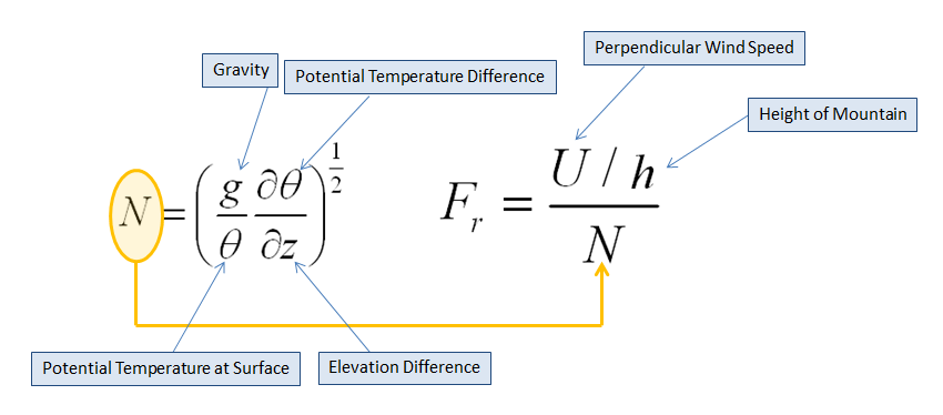
BTV has experimental output they use to determine if snows will fall on the lee side of the crest, the windward side or, under extreme blocking conditions (ie., <0.50), back up into the valley. It's found here:
https://www.weather.gov/btv/froudeALL
I posted this earlier, I think, but here's the primer on it:
https://www.weather.gov/btv/froude
More scholarly reading:
https://web.stanford.edu/~fringer/publications/mayer-jfm-2017.pdf
As an aside, if I ever went back to school the project I want to do is applying this to the west to see if you can use it to untangle the different rain shadows and such. The simple rain shadow / terrain explanation doesn't do a very good job of predicting Western climate.
-
1
-
-
Based on where the pivot looks to be, SW CT is going to verify on the high end of the forecasts. That big band is slowing down overhead.
-
Just now, STILL N OF PIKE said:
What town you in
Cape Elizabeth, ME.
NAM is a nothing burger here. No tertiary development and the big band is at a min when overhead.
Canadians have us on the cold side of the tertiary low that becomes the dominant consolidated circulation - so we get 20"
para has us at 16", but mostly from the first big band with some wrap around mood flakes.
Euro has been waffling back and forth between 10" and 16" from run to run.
Uncle. No idea what's coming.
-
Literally have reliable models showing anywhere from 5" to 20" with virga 60 miles to my south. I am rarely salty about DA MODLEZ but this is pushing even my tolerance for this [stuff].
-
 1
1
-
-
The storm is like literally happening right now and I would be totally unsurprised by anything between 6" and 16" in Cape Elizabeth. It's almost stupid how uncertain it all is.
Also, the ensembles suck for capturing the actual spread of possible outcomes.
-
What’s the latest Euro showing for the Son of Blizzard tomorrow in Maine?
-
1
-
-
Ugh. Tertiary low on NAM too far east for anyone this side of MDI.
-
It will shock no one who has lived through even one of these to learn that the WAA is stronger and faster than modeled down south. Philly area is mixing earlier than forecast. Yes, I want to see your surprised face.
Marginally helpful up here, I imagine.
-
Just now, CoastalWx said:
And don’t look past later Tuesday to see what’s wrong tries to spin north like the euro tried to show.
Shows up, albeit not as strong, on the GFS para too. And of course the UKMET turns that last piece into the main show.
-
Just now, ORH_wxman said:
If I was still forecasting for union, I’d go 10-16” for you and prob most of CT except maybe like GON over to old Lyme and then it ramps back up near HVN on the south coast. I’ll go 12-18” for me/ORH area and 495 belt up toward Ray.
Prob 8-12” for interior SE MA...including up into BOS though west side toward Jerry would add a few inches to that range. 6-10” of absolute slime for Scooter on the south shore.
I admit that I’m not hugely confident in the CT forecast or the coastline of E MA. Seems to be more variance there on the models than a place like ORH or interior E MA. I could see things breaking heavier too for CT...there’s a chance western parts could get in on the ML goodies though it feels like to me the main benefit will be more out in the Catskills and NNJ/NE PA..but even if they get clipped or it keeps the WCB a little slower to depart, then maybe we see some 16-20+ numbers there .
Im really hoping the 00z runs iron out some of the variance we’ve seen.
At least one exciting thing about this system is there are several unknown factors going into it.
Do you have a good analog to this system? While the numbers aren't historic or anything, it seems a bit different from many of the classic storms? The best I came up with was "Like 1996, but if you turned the dial down from 10 to 8 in every dimension other than, perhaps, duration".
-
3 minutes ago, ORH_wxman said:
If that rejuvenation is real, then that would make me increase the numbers up there not cut them back.
I freely admit to being new to forecasting up here. Spent much of the last few days combing through the reanalysis of some of the big Portland storms, and they kind of look like this, but also kind of not? It's not so easy to find a good analog.
Anyways down in NYC, if you get a big CCB band going over NYC, it tends to steal from the Catskills. Those CCB processes tend to be more zero sum, and driven by random chance as opposed to topography. Whereas the LLJ/WWA processes are more generous to everyone and upslope (normally) always wins.
-
Just now, PhineasC said:
I think it's real. Euro has had it for a couple runs now.
If it's real, then that explains why your numbers are being cut a bit. Subsidence and a not-particularly-favorable-wind-for-upslope. But I dunno - with how occluded the broader low will be, I feel like it's going to play much more like an upslope event under an upper low? I don't see the forcing by the coast after the main WAA band lifts north. We shall see.
-
18Z Euro continued to be nice for ME - popping off that extra low in the GoM and stalling it over downeast ME. It's a toned down version of the amped CA models. I've been very skeptical of the secondary max in coastal NH/ME but it's persisting in the higher resolution models so who knows, maybe I'm in for a treat.
-
So much better for Maine. Everything more meridional / amplified at all levels.
-
2
-
-
Changes on NAM seem good so far for NE. Lawd, he comin
-
3 minutes ago, dryslot said:
I think this is going end up being too late this go round, It looks to blow up as its heading to Labrador.
Oh I agree with that - the real boom misses me here. I’m more wondering if we get a transfer to a GoM low that spins in the 985-990 range before reintensifying as it moves out. (12Z Euro, NAM certainly pointing that way) as opposed to the secondary storm into NS (either the GFS that misses the late phase or the 12Z UKMET that drives an intensifying 972mb low into Halifax.
-
Just now, dryslot said:
Only goes to hr 90 on 06z run, Your good for 12" at least.
I’m shamelessly IMBYing, I’m renting a house on the rocks in Cape E for the winter and I’d kill for a chance to see a full-throttle GoM blizzard. The GFS’s late evolution is weird, but so is the UKMETs, and meanwhile the Euro and NAM look more classic. GYX was all over this in her overnight discussion.
-
Does anyone have the 6Z euro maps for the late evolution? I am temporarily in Maine and following whether the final wind up is in the GoM (snowy for me) or Over NS (high and dry)
-
10 hours ago, gravitylover said:
This is the third or fourth great bird year here. Considering how flying insect and bird populations are decreasing elsewhere I'm seeing exactly the opposite.
Had 4 different species of warbler in the tree outside my window on saturday. In the middle of manhattan! Never seen anything like it.
-
If the GFS phased/amplified/cutter comes to pass, it’s a textbook setup for a big freeze in the SE. You could even see a frost into central FL with that setup. Would be bad news agriculturally given how advanced everything is already.
June 2021
in New York City Metro
Posted
94th street on UES: lots of dime size hail, biggest stones were nickel sized. A++ hailstorm would buy again.