

kdxken
-
Posts
7,120 -
Joined
-
Last visited
Content Type
Profiles
Blogs
Forums
American Weather
Media Demo
Store
Gallery
Posts posted by kdxken
-
-
I see some lightning to the West. Is this going to be a Derecho?
-
 1
1
-
 1
1
-
-
2 minutes ago, Damage In Tolland said:
There was never supposed to be one there
Oklahoma?
-
1
-
-
38 minutes ago, Modfan2 said:
Is it a rainy midweek/weekend or does that Tropical Moisture stay further east?
Praying it stays East. The way it's been going this year I doubt it.
-
1.25 total. Could have been worse.
-
1
-
-
1 minute ago, TauntonBlizzard2013 said:
.76 of Stein
Why on earth would you want more rain?
-
1 hour ago, CoastalWx said:
Radar all bark and no bite unless it's convective. This is more canal east for big rains I think.
A blessing.
-
17 minutes ago, powderfreak said:
The goal is to extend the period of time with highs in the 70s… be it in the spring or the fall. That 70/50 that some on here find so boring… just let that go for weeks and weeks.
Jerry
-
1
-
-
4 minutes ago, Damage In Tolland said:
Radar looks like HRRR will win. After this morning stuff moves east much of the heavy stuff stays mainly offshore .
Oh great, we flood

-
1
-
-
.18 from the line that came through early. Hoping to get lucky and avoid what's coming later.
-
31 minutes ago, Damage In Tolland said:
Torch!
-
35 minutes ago, powderfreak said:
True but there should be some personal responsibility involved too. Living as a zombie sounds terrible.
Anyway, great morning out. Loving the great sleeping weather lately, waking up cold to shut windows. Looks like an active evening up this way with storms.

Keep it North. Send some over to lava.
-
1
-
-
Oh good only 3 inches of rain.
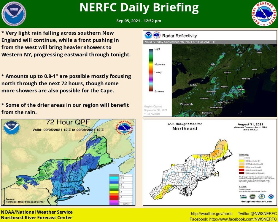
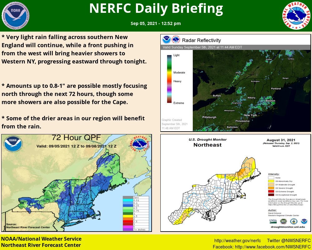
Heavy rainfall appears to be the primary threat and deep warm cloud depths will support warm rain processes. Total rainfall of 1-2 inches with localized 3 inches are possible near the I-95 corridor from late tonight through Thu. Areas of poor drainage street flooding will be possible-
1
-
-
1 hour ago, tamarack said:
Coldest of our 10 Februarys in Fort Kent, despite 1, 2, 24 and 28 being 15+ AN. All we got was a few clouds from that storm on the 17th. Feb. 10-17 averaged -4/-19 with max running -2 to -7, min -16 to -22, and the wind never quit the whole 8 days, peaking on 16 (-5/-16) and 17 (-7/-22). Those 8 days ran 22° BN, peaking at 28° BN on the 17th.
Didn't we used to have a poster from fort kent? Or was that you?
-
 2
2
-
-
So how much rain is Eastern Mass supposed to pick up with this Wednesday / Thursday mess?
-
1
-
-
Pretty sweet day.
-
1
-
-
Super more flooding.
Still have some discrepancy on how quickly the cold front moves through. Given the deep trough slowly lifting through am thinking the front will be slowly moving through like depicted by the UKMET/ECMWF/CMC/ICON guidance. The GFS/NAM are the fastest with moving the front through. Will be important in how quickly the front passes through because could have a prolonged heavy rain risk Wednesday night and especially on Thursday. Wednesday night PWATs increase to roughly 1.5-1.75" ahead of the incoming front. On Thursday south-southwesterly flow will advect in 1.75-2" PWATs. This is AOA the 90th percentile per SPC Sounding climatology for CHH for this time of year. Given antecedent conditions we can`t handle too much rainfall, so think there could be a flood risk Wednesday night and on Thursday. The current WPC Day 3 Excessive Rainfall Outlook may not be far enough west especially if things continue trending toward the slower solutions.-
1
-
-
19 minutes ago, BrianW said:
Awesome. Went yesterday on a charter boat out of Galilee and was landing bass on every cast.

Might be my favorite eating fish. So good.
-
18 minutes ago, CT Valley Snowman said:
Stein holding on in parts of NNE
Don't encourage them.
-
2
-
-
14 hours ago, Sey-Mour Snow said:
We can make a friendly wager. Something fun, I’ll go with NYC metro to southern CT to SE MASS. You go DXR to PVD just North?
What did you win? Good call!
-
20 minutes ago, weatherwiz said:
It's insane to think that even 3-months ago everyone was crying drought...now look at us.
Well two people were crying drought. We tried to tell them...
-
1
-
-
9 minutes ago, kdxken said:
4.75 at the woodyard in Sherborn.
Almost exactly the same in southborough.
-
3 minutes ago, Baroclinic Zone said:
5.64" and counting. May hit 6" with this last batch Winds gusting up to 30mph. Heading out to work.
Give a road report after you get there please.
-
4.75 at the woodyard in Sherborn.
-
12 minutes ago, Baroclinic Zone said:
You gone so long you forget names. ETauntonMA.
Awesome!!!


Severe Weather Thread - New England
in New England
Posted
Keep it there.