

kdxken
-
Posts
10,548 -
Joined
-
Last visited
Content Type
Profiles
Blogs
Forums
American Weather
Media Demo
Store
Gallery
Posts posted by kdxken
-
-
Gorgeous evening for a brewfest. The old hood.
.thumb.jpg.bacad64a176a2c17d7bafcda9ed4ad6a.jpg)
-
 6
6
-
-
40 minutes ago, Baroclinic Zone said:
Tickling 80F. Blowtorch of a day/
79° / 44° . It's awesome. Payback's going to be a b****.
-
 1
1
-
-
58 minutes ago, jsw said:
NWS now calling for 1" or more of rain Tuesday - Wednesday here. Nice!

We rain.
-
1
-
 1
1
-
 1
1
-
-
5 hours ago, Ginx snewx said:
Cold will take hold when the rivers are bankful.
November is going to be a very wet month.
I kind of have that feeling as well. The old rubber band. October is a notoriously dry month anyway. Think I'm going to make a push to sell all my wood by the end of the month. No sense in loading trucks in the rain.
-
 1
1
-
-
50 minutes ago, HoarfrostHubb said:
I'm leaning towards minor changes around the 20th-ish
-
3 hours ago, dendrite said:
37.0° with some frozen dew
Glad you unfroze and pinned the October thread to the top.
-
 1
1
-
2
-
-
10 hours ago, Damage In Tolland said:
Will be some 90 degree readings
No one bites at the nonsense anymore. Must be discouraging.
-
 1
1
-
-
1 hour ago, metagraphica said:
64/42 You can tell the weather is boring as f*ck. The monthly pinned thread hasn't even been changed yet.
Dendrite asleep at the wheel.
-
36 minutes ago, Baroclinic Zone said:
1st “round” of golf in over a year. Office scramble at New England cc. Wish I could have played more this year but was not in the budget. Sucked bad. Enjoyed the day though.
How did you do on 9? The Sharp dog leg right. That hole is a bear.
-
35 minutes ago, Baroclinic Zone said:
1st “round” of golf in over a year. Office scramble at New England cc. Wish I could have played more this year but was not in the budget. Sucked bad. Enjoyed the day though.
I love New England CC especially in the fall. Not easy.
-
49° quite a change.
-
1
-
-
5 minutes ago, butterfish55 said:
It's like death and taxes.....Kev is going to be upset when he wakes up at 4:00 to run
Sent from my Pixel 10 Pro XL using Tapatalk
-
3
-
1
-
-
Ho hum the Red Sox beat the Yankees. Boring game...
-
2
-
-
3 hours ago, dendrite said:
Survived the dysentery, but succumbed to 75/65.
Those days are gone. Used to be Donner pass meant thigh bones and skulls .Now it's hot dogs and hamburgers...
-
My daughter's report from around Campton New Hampshire. Foliage pretty much sucks. Lots of dried and dead leaves. Beautiful day for a hike though.
.jpg.951fc00ae5aaf18d2dba7215aa827c78.jpg)
.jpg.4bd848133b12ebfd84557bed97077b0a.jpg)
-
6
-
-
3 hours ago, WxWatcher007 said:
This’ll be my best September for solar
Best September for anything. Best August for anything. Come on October you can do it!
-
2
-
-
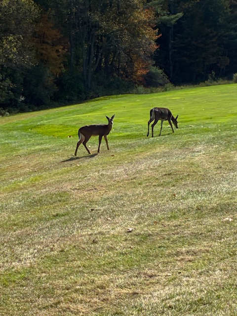
On 9/28/2025 at 8:21 PM, mreaves said:
Couple of wildlife pictures. The first one was from a friend’s trail camera a few miles away from where we live and the second one was at the golf course today.
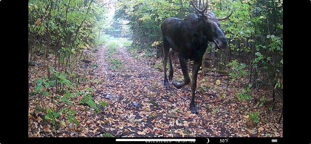
Here's a couple from my game camera in the wood yard. The deer were loving the rain . Not me...
-
4
-
-
Just found this guy. Seems reasonable
-
5
-
-
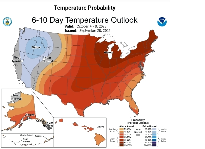
26 minutes ago, Typhoon Tip said:
Keep in mind… We’re getting towards the time of the year where above normal may not necessarily be “warm” in the sensible weather. This relativity is especially true when you get towards Halloween.
As an aside, the first week of October may have some exceptionally anomalies, but we’ll see…
Also +.01 is above normal That chart doesn’t mean you’re gonna roast because it’s extra dark redYou can explain it to him but you can't make him understand. I've given up.
-
1
-
-
14 minutes ago, ineedsnow said:
first freeze incoming?
Wednesday NightPatchy frost after 5am. Otherwise, mostly clear, with a low around 32. North wind around 6 mphCool weather soon to be only a memory.
-
1
-
-
2 hours ago, Baroclinic Zone said:
Guess it rained a bit overnight here. Looks like around 1/10”.
Same in the wood yard but not in southborough.
-
1 hour ago, Damage In Tolland said:
Ensembles and weeklies are a very very warm month. Hope that changes
Why? Sounds perfect.
-
Nicest August ever, September ever, let's make it a three-peat for October.
-
On 9/27/2025 at 1:12 AM, tunafish said:
Birds everywhere. Can hear em chirping outside as they fly by.
.jpg.32f33efb80ba451af17a7b6a6dc44802.jpg)
Spooky Season (October Disco Thread)
in New England
Posted
Lots of planes.