

ravensrule
-
Posts
11,387 -
Joined
-
Last visited
Content Type
Profiles
Blogs
Forums
American Weather
Media Demo
Store
Gallery
Posts posted by ravensrule
-
-
Light snow in Pikesville. Probably .3". Untreated roads and parking lots are covered.
-
URGENT - WINTER WEATHER MESSAGE
National Weather Service Baltimore MD/Washington DC
327 PM EST Thu Jan 31 2019

MDZ004>006-011-503-505>508-VAZ505-010430-
/O.NEW.KLWX.WW.Y.0009.190201T1100Z-190201T2000Z/
Frederick MD-Carroll-Northern Baltimore-Southern Baltimore-
Northwest Montgomery-Northwest Howard-
Central and Southeast Howard-Northwest Harford-Southeast Harford-
Western Loudoun-
327 PM EST Thu Jan 31 2019

...WINTER WEATHER ADVISORY IN EFFECT FROM 6 AM TO 3 PM EST
FRIDAY...

* WHAT...Snow expected. Total snow accumulations around one inch,
  with locally higher amounts of 2 inches near the Mason-Dixon
  Line. The steadiest snow is expected between 7 AM and noon
  Friday.

* WHERE...Portions of northern and central Maryland and northern
  Virginia, including the Baltimore metropolitan area.

* WHEN...From 6 AM to 3 PM EST Friday.

* ADDITIONAL DETAILS...The hazardous conditions will impact the
  morning commute with snow covered and slippery roads, making
  travel difficult.

PRECAUTIONARY/PREPAREDNESS ACTIONS...

A Winter Weather Advisory for snow means periods of snow will
cause primarily travel difficulties. Expect snow covered roads
and limited visibilities, and use caution while driving.
-
1. Come on 0
-
 1
1
-
 1
1
-
-
Just now, BaltimoreWxGuy said:
Where you at again? Hasn’t come thru in Dundalk yet
Stevenson
-
What an amazing squall. One of the better ones i ever remember. For 10 minutes it was complete whiteout conditions.
-
 7
7
-
-
Hallelujah. The streets have caved.
-
3
-
-
Light to moderate snow in Pikesville. Parking lot snow covered along with the side of the roads.
-
Light to moderate snow in Pikesville with full car and grass stickage.
-
1
-
-
1 minute ago, WxUSAF said:
Spotter report of 1.8” just NW of Leesburg!
It's Ji with his slanted ruler.
-
2
-
-
Pouring fatties here. Finally starting to stick on the mulch
-
Moderate snow in Pikesville but it's still melting on contact.
-
Steady light snow in Pikesville
-
It's snowing lightly in Pikesville
-
URGENT - WINTER WEATHER MESSAGE
National Weather Service Baltimore MD/Washington DC
1051 AM EST Tue Jan 29 2019

MDZ003>006-507-300000-
/O.CON.KLWX.WW.Y.0008.000000T0000Z-190130T0200Z/
Washington-Frederick MD-Carroll-Northern Baltimore-
Northwest Harford-
1051 AM EST Tue Jan 29 2019

...WINTER WEATHER ADVISORY REMAINS IN EFFECT UNTIL 9 PM EST THIS
EVENING...

* WHAT...Intermittent light snow will continue through 1 PM this
  afternoon, then steadier snow will develop between 1 and 3 PM
  before ending between 6 PM and 9 PM this evening. Total snowfall
  accumulations of 1 to 2 inches are expected, with isolated
  amounts around 3 to 4 inches possible near the Mason- Dixon line
  in northeastern Maryland.

* WHERE...Portions of northern Maryland.

* WHEN...Winter Weather Advisory is in effect until 9 PM EST this
  evening.

* ADDITIONAL DETAILS...Plan on slippery road conditions.
  Temperatures will fall well below freezing during the evening
  commute, causing any wet or slushy untreated surfaces to freeze.
-
1 hour ago, psuhoffman said:

I’m in. Nice map.
-
1
-
-
8 minutes ago, Bob Chill said:
I know what you mean. 60s next week are going to be awesome. On another note... remember I mentioned the wife and I might be moving to lake gaston when our teenagers are on their own? The conversation has changed. Now we're thinking about lake champlain. Heh
I’m thinking of Lake Placid just so i can take pictures and troll Ji.
-
1
-
-
3 minutes ago, Ji said:
Can't wait till this event is done
It’s a non event for you so it’s done already.
-
1
-
-
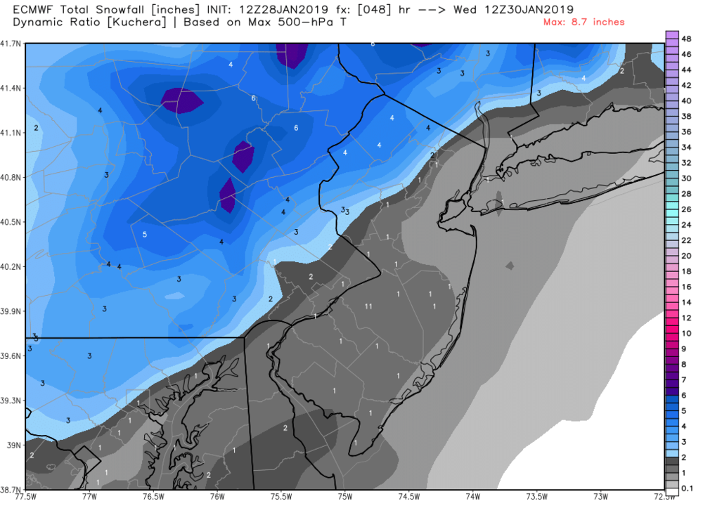
URGENT - WINTER WEATHER MESSAGE
National Weather Service Baltimore MD/Washington DC
258 PM EST Mon Jan 28 2019

MDZ011-504-506-508-VAZ052-053-501-502-505-506-290400-
/O.NEW.KLWX.WW.Y.0008.190129T1700Z-190130T0300Z/
Southern Baltimore-Central and Southeast Montgomery-
Central and Southeast Howard-Southeast Harford-
Prince William/Manassas/Manassas Park-Fairfax-Northern Fauquier-
Southern Fauquier-Western Loudoun-Eastern Loudoun-
258 PM EST Mon Jan 28 2019

...WINTER WEATHER ADVISORY IN EFFECT FROM NOON TO 10 PM EST
TUESDAY...

* WHAT...Any rain will change to snow during the afternoon hours.
  Total snow accumulations of 1 to 3 inches expected.

* WHERE...Portions of central and northern Maryland and northern
  Virginia.

* WHEN...From noon to 10 PM EST Tuesday.

* ADDITIONAL DETAILS...Plan on slippery road conditions. The
  hazardous conditions will impact the evening commute.
  Temperatures will fall well below freezing during the evening,
  causing any moisture or slush to freeze on untreated surfaces.
-
2
-
-
9 minutes ago, Eskimo Joe said:
Advisories going out now.
URGENT - WINTER WEATHER MESSAGE
National Weather Service Baltimore MD/Washington DC
258 PM EST Mon Jan 28 2019

MDZ004>006-503-505-507-290400-
/O.NEW.KLWX.WW.Y.0008.190129T1100Z-190130T0200Z/
Frederick MD-Carroll-Northern Baltimore-Northwest Montgomery-
Northwest Howard-Northwest Harford-
258 PM EST Mon Jan 28 2019

...WINTER WEATHER ADVISORY IN EFFECT FROM 6 AM TO 9 PM EST
TUESDAY...

* WHAT...Light mixed precipitation is expected during the morning
  and midday hours before becoming all snow in the afternoon.
  Total snow accumulations of 2 to 4 inches expected.

* WHERE...Portions of north central Maryland.

* WHEN...From 6 AM to 9 PM EST Tuesday.

* ADDITIONAL DETAILS...Plan on slippery road conditions. The
  hazardous conditions will impact the morning and evening
  commutes. Temperatures will fall well below freezing during the
  evening, causing any moisture or slush to freeze on untreated
  surfaces.
-
2
-
-
2 minutes ago, Bob Chill said:
I'll pm you the unedited panels...
On another note... now the eps is starting to pick up on another chance for a light event between d8-11. lol. Might end up being the lamest Feb torch we've ever seen. lol
Nice, thank you. I will be very happy with 3 light events over the next 10 days. I'm not a big or go home type of guy, unfortunately some of my past girlfriends have been.
-
1
-
-
Just now, Bob Chill said:
Yea, euro/eps can suffer from the same dispersion issues as the gefs in the mid range. Barely a signal for the light event on the 0z EPS and now suddenly strong support. lol. Nothing fancy but looks like most members are in the 1-2" range with a few bigger solutions in the mix. Considering how it's suddenly popping up on the euro and now eps, if the op starts juicing up the eps will follow instead of the the other way around. Looks like a "private event" too with only our area getting anything for now.
Nothing talks to me more than a private event. When it juices up please let me know so i can take the pictures "private".
-
Just now, Fozz said:
I'll take it... easily. I don't get all the fuss especially from the northerners.
I will definitely take 3-4", especially when it falls in a shorter period. Even the 4" storm sucked since it took 24 hours to get that.
-
1
-
-
Just now, MD Snow said:
@psuhoffman you do realize that you are the most likely to stay all snow and get the most accumulations out of this, right?
I think he realizes that. 3" sucks though when you have been on the short end of the stick all winter.
-
1
-
-

February 1, 2019 Clipper Snow
in Mid Atlantic
Posted
Snow+. Definitely heaviest rates of the day.