

AMDEW80
-
Posts
107 -
Joined
-
Last visited
Content Type
Profiles
Blogs
Forums
American Weather
Media Demo
Store
Gallery
Everything posted by AMDEW80
-
Central PA - Jan 31 to Feb 2 Winter Storm
AMDEW80 replied to MAG5035's topic in Upstate New York/Pennsylvania
yea today has been brutal for me as well... sitting watching the snow line 30 miles east of me All day. Hope to get into the action later as the models are showing...but I'm starting to have my doubts. Pumped for everyone else getting in on the action! -
Central PA - Jan 31 to Feb 2 Winter Storm
AMDEW80 replied to MAG5035's topic in Upstate New York/Pennsylvania
The radar looks beautiful around the Harrisburg area and east, enjoy. I have been sitting outside the western edge all day. Hopefully will get back into the snow at some point. -
Central PA - Jan 31 to Feb 2 Winter Storm
AMDEW80 replied to MAG5035's topic in Upstate New York/Pennsylvania
If you wanted me to guess... it’s day drinking imagine day two and three of this event! -
Central PA - Jan 31 to Feb 2 Winter Storm
AMDEW80 replied to MAG5035's topic in Upstate New York/Pennsylvania
Was thinking looking at the forecast... what has fallen here and hopefully what is to come, is straight fluff, 25 mph gusts tomorrow into Tuesday could be interesting...in a good way -
Central PA - Jan 31 to Feb 2 Winter Storm
AMDEW80 replied to MAG5035's topic in Upstate New York/Pennsylvania
just hit 3 inches with the heaviest snow of the day falling. 21 degrees. -
Central PA - Jan 31 to Feb 2 Winter Storm
AMDEW80 replied to MAG5035's topic in Upstate New York/Pennsylvania
high end is real nice for everyone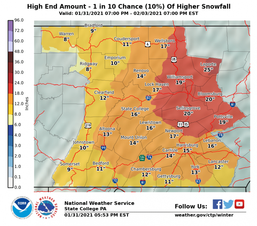
-
Central PA - Jan 31 to Feb 2 Winter Storm
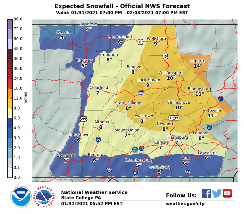
AMDEW80 replied to MAG5035's topic in Upstate New York/Pennsylvania
and for update #42393 of the day from ctp
-
Central PA - Jan 31 to Feb 2 Winter Storm
AMDEW80 replied to MAG5035's topic in Upstate New York/Pennsylvania
Just got bumped up to a WSW from WWA in Tioga county. Will be interesting to see how this plays out. -
Central PA - Jan 31 to Feb 2 Winter Storm
AMDEW80 replied to MAG5035's topic in Upstate New York/Pennsylvania
19 degrees with light snow Good luck everyone! -
December storm repeated?!?!
-
They started 3 mile island back up!
-
Just when I started to get pulled in...ouch.
-
December 16 2020 CTP Snowstorm Disco and Obs
AMDEW80 replied to pasnownut's topic in Upstate New York/Pennsylvania
I ended up with around 27, was an awesome storm up here, especially late night I got the end of that band that slammed Binghamton. The rates were incredible. Having issues with with the file size of my photos... -
December 16 2020 CTP Snowstorm Disco and Obs
AMDEW80 replied to pasnownut's topic in Upstate New York/Pennsylvania
US National Weather Service State College PA 51 seconds ago Here are the highest reports snowfall totals as of 2AM. Heavy snow continues between I-80 and US-6 in North Central PA. Totals in excess of 2 feet are likely in northern Clinton and northern Lycoming counties where this band has been parked for several hours. Full list of latest reports: https://nwschat.weather.gov/p.php… #PAwx Thursday 12/17 @ 2:15AM -
December 16 2020 CTP Snowstorm Disco and Obs
AMDEW80 replied to pasnownut's topic in Upstate New York/Pennsylvania
i just got in from playing outside...i'm pretty speechless. maybe the best rates of the day for me...if this band stays over me for awhile my total could be pretty crazy. I have a mountain of snow just from continually shoveling a small path to my wood pile on the patio throughout the day. -
Dec 16-17 Storm OBS Thread
AMDEW80 replied to BuffaloWeather's topic in Upstate New York/Pennsylvania
I'm sitting at the tail end of the band back in pa....crazy! showing no signs of letting up! -
December 16 2020 CTP Snowstorm Disco and Obs
AMDEW80 replied to pasnownut's topic in Upstate New York/Pennsylvania
I have been saying a few times today while looking at the radar "renovo is getting hammered!" my guess is they may take the cake for the highest total. -
December 16 2020 CTP Snowstorm Disco and Obs
AMDEW80 replied to pasnownut's topic in Upstate New York/Pennsylvania
going to be a fun day of playing/cleaning up tomorrow. good times! looking like the band around me is sneaking just a touch north to give me a fantastic finish! -
Dec 16-17 Storm OBS Thread
AMDEW80 replied to BuffaloWeather's topic in Upstate New York/Pennsylvania
enjoy! still coming down hard with 13.5 on the ground here is wellsboro, pa -
December 16 2020 CTP Snowstorm Disco and Obs
AMDEW80 replied to pasnownut's topic in Upstate New York/Pennsylvania
up to 13.5 here.... love this nws grid forecast. Detailed Forecast Tonight Snow. The snow could be heavy at times. Low around 18. Northeast wind around 6 mph. Chance of precipitation is 100%. Total nighttime snow accumulation of 14 to 20 inches possible. Thursday A chance of snow before 1pm. Cloudy, with a high near 26. North wind 3 to 6 mph. Chance of precipitation is 50%. New snow accumulation of less than one inch possible. -
December 16 2020 CTP Snowstorm Disco and Obs
AMDEW80 replied to pasnownut's topic in Upstate New York/Pennsylvania
wowzer, haven't seen snow like this in my 4 years of living here.... up to 9 inches sn+ 19 degrees -
December 16 2020 CTP Snowstorm Disco and Obs
AMDEW80 replied to pasnownut's topic in Upstate New York/Pennsylvania
so this is what those heavier bands look like 6 inches sn+ -
December 16 2020 CTP Snowstorm Disco and Obs
AMDEW80 replied to pasnownut's topic in Upstate New York/Pennsylvania
just passed 3 inches here, intensity is getting better. 18 degrees -
December 16 2020 CTP Snowstorm Disco and Obs
AMDEW80 replied to pasnownut's topic in Upstate New York/Pennsylvania
first flakes earlier than expected Wellsboro, pa -
nice, close by... I'm between wellsboro and ansonia.


