

Nibor
-
Posts
2,385 -
Joined
-
Last visited
Content Type
Profiles
Blogs
Forums
American Weather
Media Demo
Store
Gallery
Posts posted by Nibor
-
-
I work near NYU and Broadway is starting to slush over. Side roads are starting to snow cover. Roads in parts of Manhattan might suck in a few hours.
-
 4
4
-
-
Kinda reminded of the December 2020 storm where the banding went north of modeling and dropped 40 in Binghamton. To a lesser extent what’s happened for our northern board members.
-
8 minutes ago, snywx said:
Over 7" now
Wow that’s impressive
-
1
-
-
About an inch in Astoria. Roads are slushy or snow covered.
-
Mix line making its way south:
https://weather.cod.edu/satrad/nexrad/?parms=DIX-N0C-1-24-100-usa-rad
-
2
-
-
Switching to frozen in Astoria.
-
2 minutes ago, MJO812 said:
It's going to be slightly lower than 10:1 but we should be good.
I could see it being 5:1 in and around the city and parts of LI.
-
33 minutes ago, MJO812 said:
Yep wtf

Okay I buy the south trend it can stop now, please.
-
2
-
-
Just now, coastalplainsnowman said:
I just want to know if I was the inspiration for this, since I said I was curbing my enthusiasm. If so, well done.

-
1
-
 2
2
-
-
Just now, jm1220 said:
Time to buy in?

-
4
-
 1
1
-
2
-
-
2 minutes ago, coastalplainsnowman said:
Relax?
Sit in an unrestrained position and relieve yourself of worries.
-
2
-
-
13 minutes ago, NEG NAO said:
Tell that to whoever is in charge at Mt. Holly
They just called me to let you know that they'll let you know what they think when they're ready.
-
1
-
-
11 minutes ago, nycwinter said:
the sun angle is so warm just yesterday i felt it..
The warmth was just because you were standing above a subway grate.
-
1
-
3
-
-
-
2 hours ago, LibertyBell said:
It's so great to see a multimillionaire dollar QB go down, I want him to keep getting pounded into the ground repeatedly.

-
3 minutes ago, brooklynwx99 said:
you are relying on a potent 500mb shortwave here… the ECMWF accomplishes that with a great 500mb pass. i do think that it’s notable that the ECMWF is digging in under 96 hours out

Slightly delayed this run.
-
1
-
-
Euro is slightly south and weaker, confluence orientation up north is better. Overall evolution is slower than 12z.
-
1
-
-
1 minute ago, Krs4Lfe said:
I have to say, one thing that does perplex me are the official forecasts (NWS, TWC, and the cable weather news networks) calling for almost nothing here in NYC. Over the last 24-36 hours, almost every model run has shown 5+ for NYC. I wonder what their rationale is. Maybe the north trend will continue, or lack of cold air leading up to the storm? Seems to be a big disconnect between the model data and the humans that are making the forecast.
Marginal temps, snow maps aren't going to account for that.
-
1 hour ago, snowman19 said:
11/1-2/9: 2.3 inches of snow, total
Not everyone who lives south of 84 reside in NYC but continue living insufferably.
-
1
-
 1
1
-
-
2 hours ago, snowman19 said:
It will probably be rain up to I84 by 0z Saturday night
On 1/4/2024 at 1:35 AM, snowman19 said:Becoming more confident that this is going to be an I-84 north event. Expect further corrections NW on tomorrow’s guidance. IMO there will be little if any snow with this until you get 40+ miles northwest of the city. The airmass is marginal as all heck. Also think there is going to be major midlevel warm nose issues in the metro area….watch the mesos in the last 24 hours, some areas may not even see snow and start as sleet. 10:1 snow maps are going to be laughably inaccurate
Time is a flat circle
-
1
-
-
Bro... lmfao


-
1
-
 1
1
-
-
4 minutes ago, brooklynwx99 said:
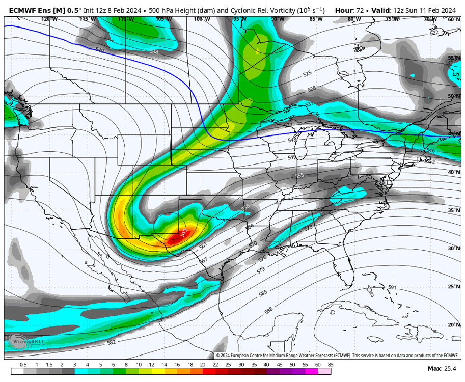
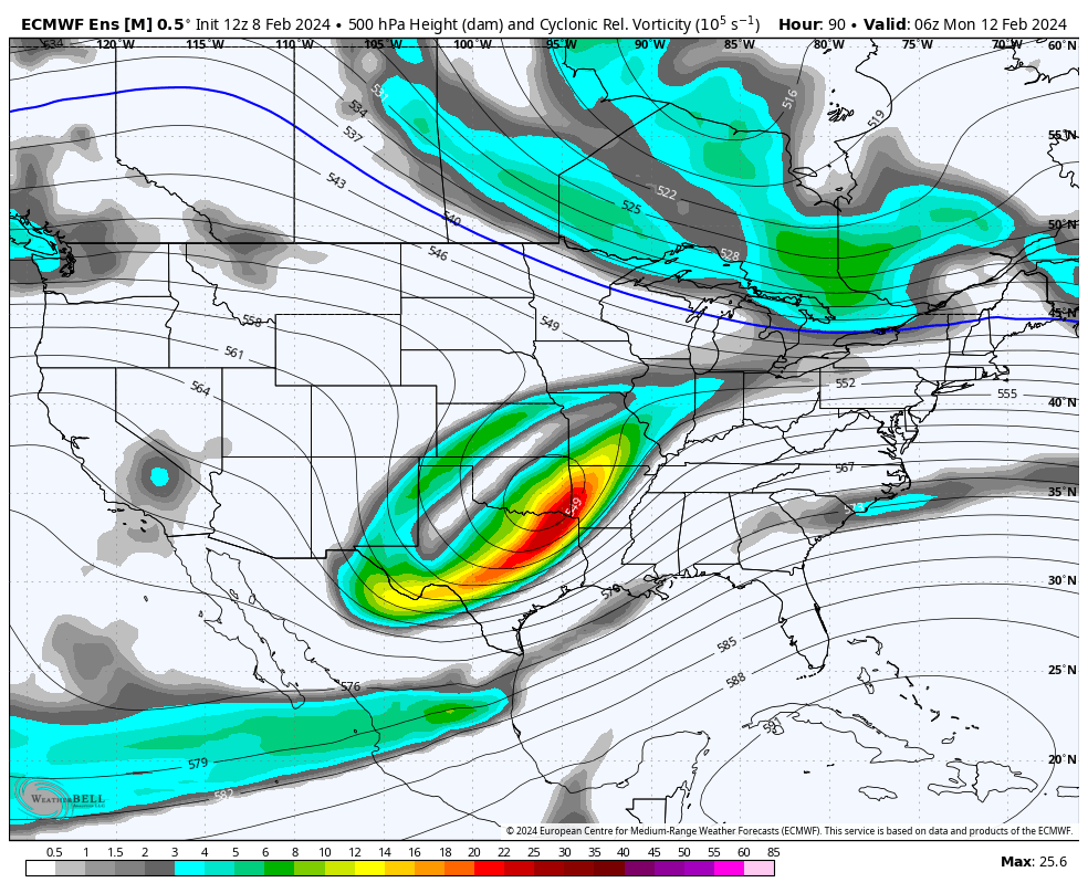
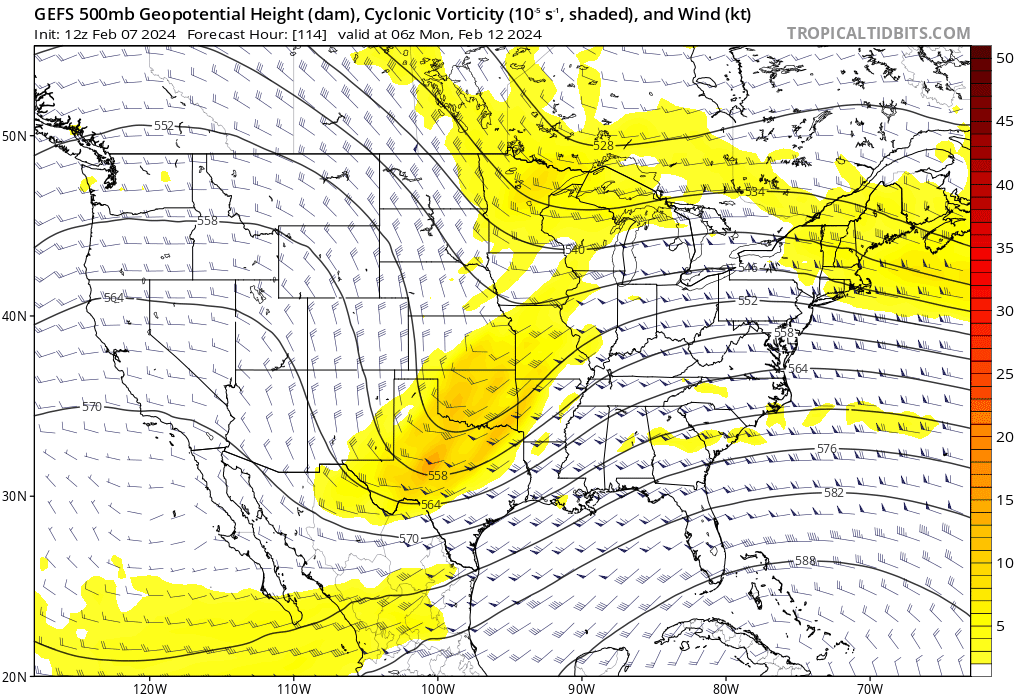
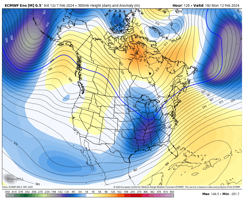
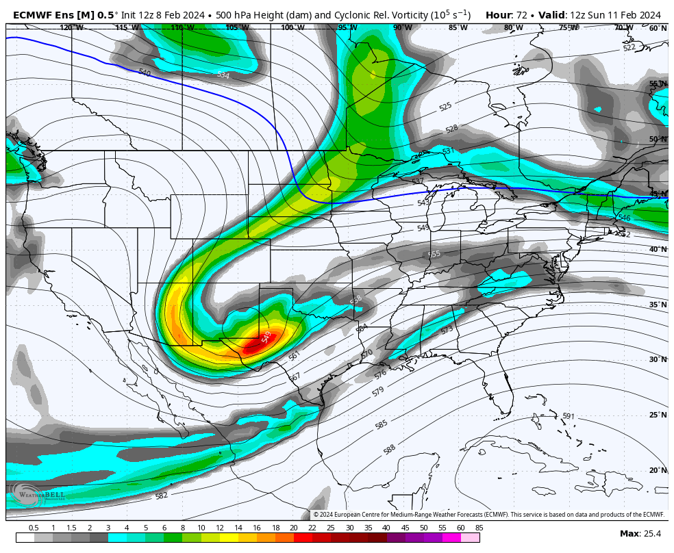
decided to place some more coherent thoughts here. this is effectively a system where the northern and southern streams are in conflict and either phase or remain separate. the northern stream (NS) can be seen over the Dakotas, and the southern stream (SS) can be seen over the Four Corners region
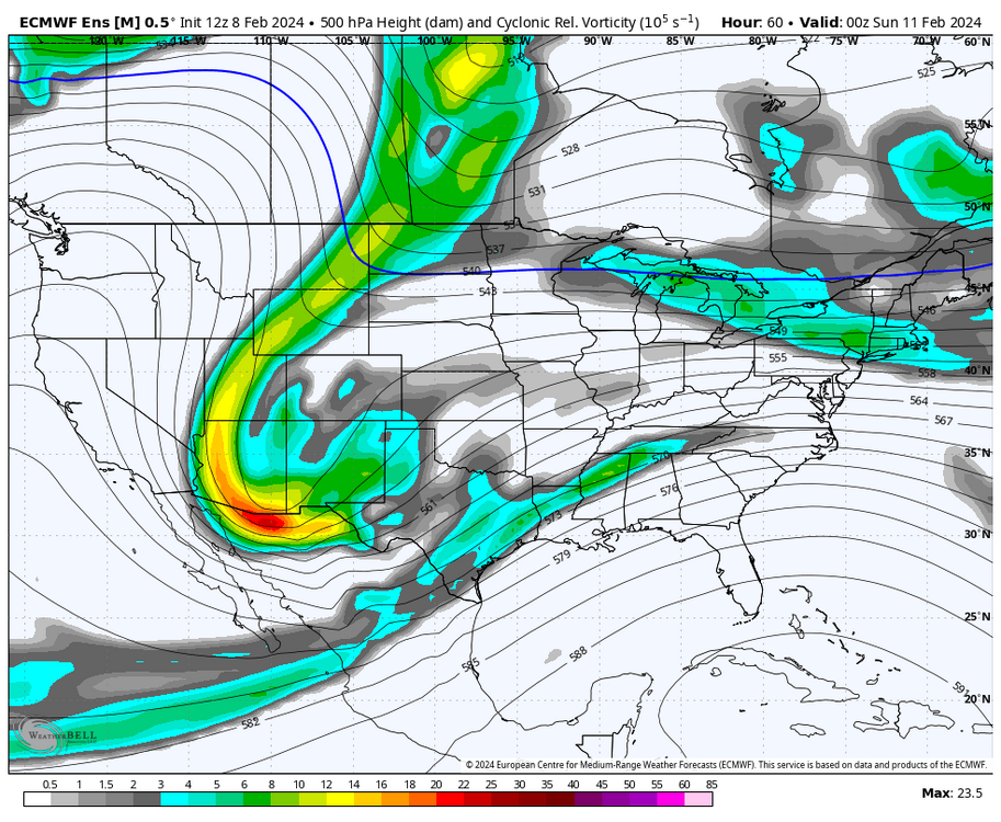
as we head through Sunday, it is a matter of how the two streams interact. there has been a consistent trend across guidance to push the NS ahead of the SS such that instead of phasing with the NS, it actually ends up compressing the flow, like so. the NS is strung out north of the Great Lakes, while the SS remains hung back over the Ozarks. this is a big departure from what we were seeing yesterday... GEFS trend loop attached, you can see the two streams drift apart


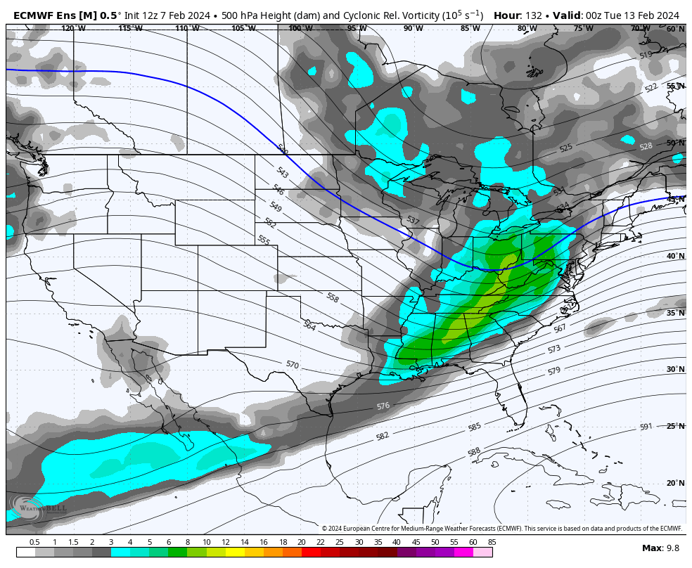
finally, once we're at the start of next week, the SS vort is effectively running into a wall of confluence rather than phasing with the NS. this promotes an intense precipitation field from a potent SLP. the ensemble members from the EPS and GEFS are routinely sub-990mb. again, this is a consistent trend to increase confluence and decrease phasing looking from 12z yesterday to now:
.thumb.png.05c672122e6d3029fdb2809d8eb19540.png)

so, this leads to a SLP that's farther south rather the borderline inland runner that was showing up on earlier runs of the ECMWF and CMC. by the way, even the CMC has decidedly moved towards less stream interaction. confidence of 3" or more on the EPS has moved well south of where it was yesterday. this is a big move for the EPS, as it's generally pretty consistent, even at this range. the greatest snowfall remains to the north of I-78 and especially I-84:
let's look at the general 500mb pattern across North America to see if any of this is even viable. we can see ridging developing across the high latitudes, which is representative of the pattern change that is ongoing at this time. there is AK ridging, providing some colder air into the flow, and there is a lobe of the polar vortex that's providing some confluence just north of the Great Lakes. there is also ample low pressure over the North Atlantic, which promotes more confluence than not. the southern stream shortwave has a much harder time raising heights ahead of it with the flow downstream, so this kind of shortwave moving ENE rather than NE or NNE is indeed viable. again, notice the trend with less stream interaction and lower heights in SE Canada

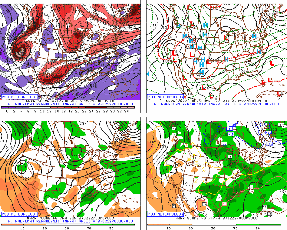
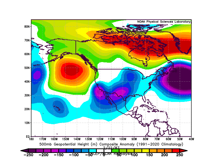
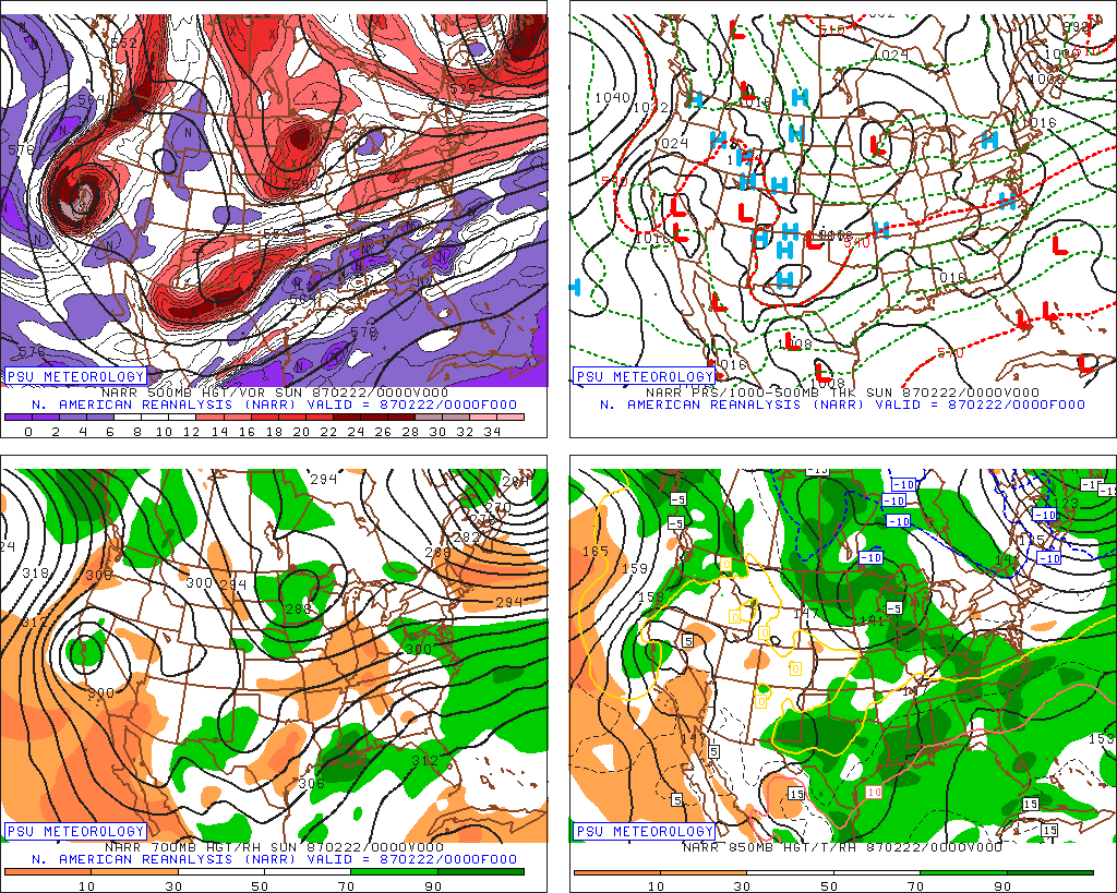
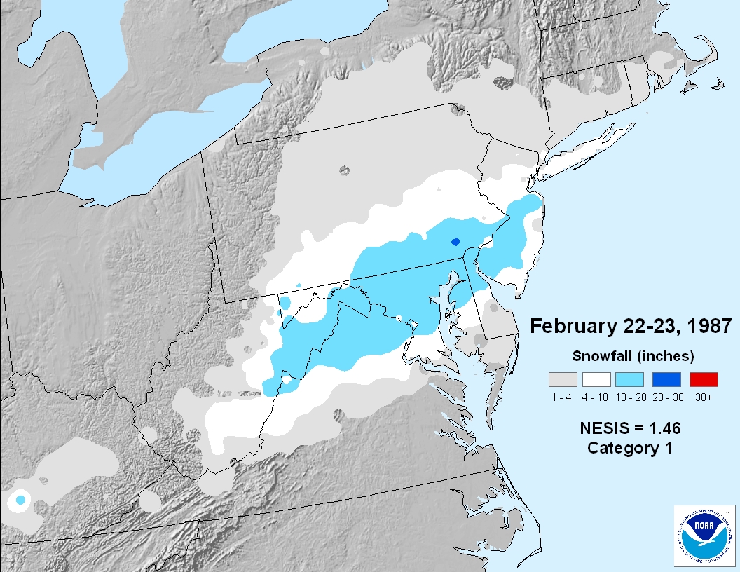
are there any analogs that we can look at? there is only one that I'm really aware of, which is 2/23/87. this was also a pretty strong El Nino February, and I think the setup shares some features. both setups share the same kind of stream interaction that we're seeing... a potent SS vort and a northern stream vort that is generally out ahead of the system. there are a couple of differences, though. the first is that with this system, the northern stream did have a partial phase at the end, which is not what we're currently seeing (although possible!). second, there was a much more well established blocking pattern in place, as shown by the 500mb anomalies. there was much more confluence in the northern Atlantic, which is a more "classic" setup for a significant snowfall event. the 1987 event was a major snowfall event for the Mid-Atlantic, which is definitely unlikely here. however, take a bit of strength out of the eventual result (less phasing here) and shift things north (less confluence here), and the general axis and half of the total snowfall could be quite realistic

so, we will see where things go from here. the whole setup is definitely a bit of a needle threader, as the confluence is not locked in and is pretty much entirely dependent on the movements of the northern stream vort. therefore, there can be a renewed trend back north or even a move back to a phasing scenario. however, it seems like the trend is for more destructive interference from the NS rather than constructive, which is leading to increased confidence in a more southern solution. I would still pinpoint north of I-84 as the safest bet to see anything legit out of this, but anyone north of I-78 is in play. this is also more of a latitude than longitude based event, so being on the coast isn't that big of a deal, it would just hurt ratios. hopefully we have more clarity tomorrow afternoon (doubtful)

Quality postSimilar thoughts:
-
2
-
-
3 hours ago, bluewave said:
Several factors lining up for a potentially very active Atlantic hurricane season.
This specific graph is terrifying as shit
-
1
-
 1
1
-
-
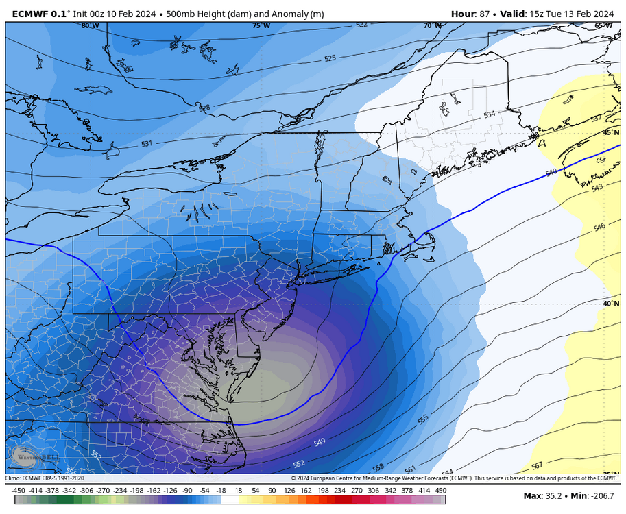
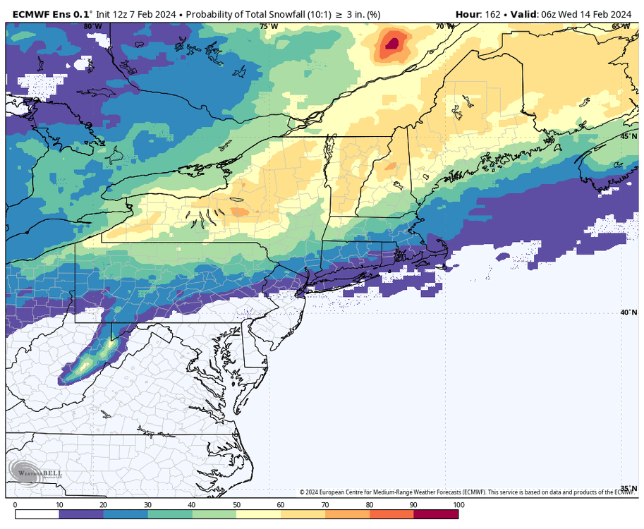
8 minutes ago, SnoSki14 said:
You really need a strong, dynamic system for the 13th as airmass is not very good but there is some potential.
Northern elevated areas would be favored again for the 13th storm depending on track
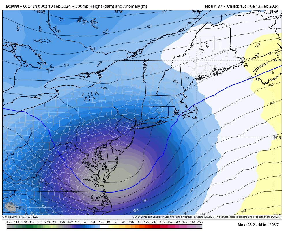

.png.0a5806f7197b0f866721d6b12b05daf4.png)
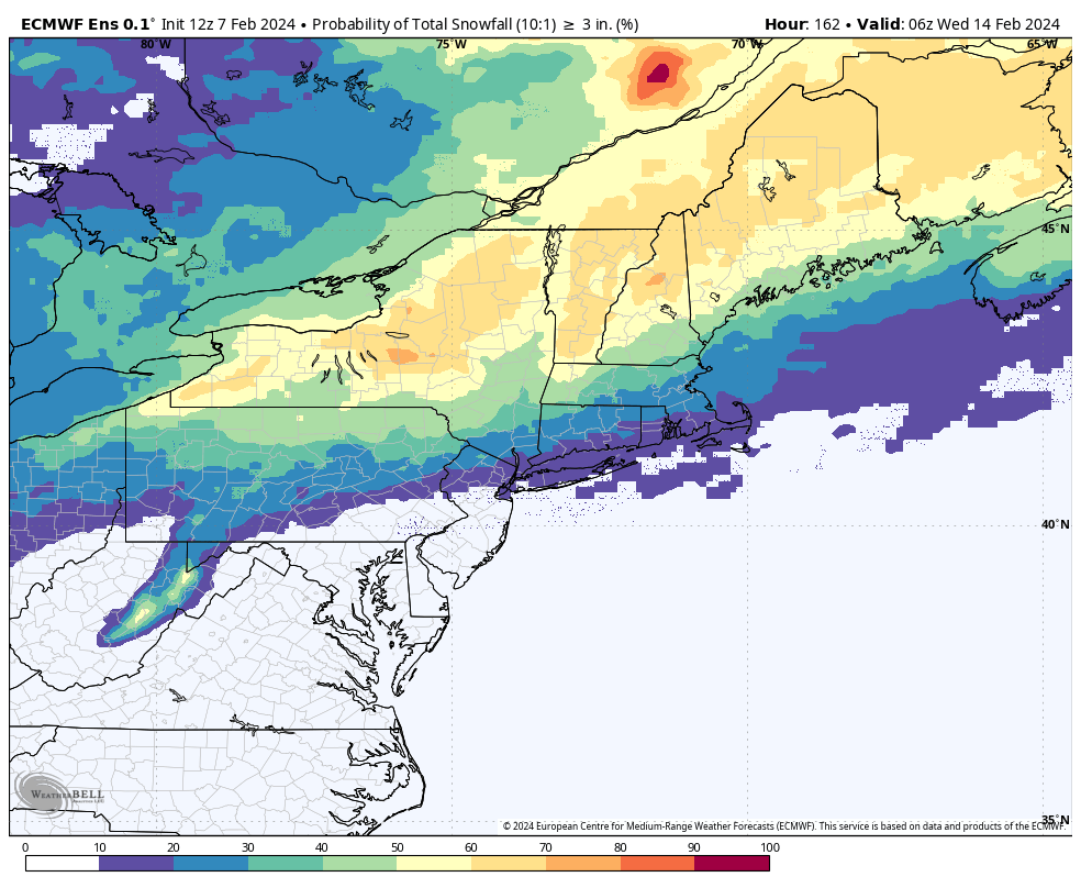
2/13 Significant/Major Winter Storm Discussion & Observations
in New York City Metro
Posted
From my commute this morning.