

The Ole Bucket
-
Posts
567 -
Joined
-
Last visited
Content Type
Profiles
Blogs
Forums
American Weather
Media Demo
Store
Gallery
Posts posted by The Ole Bucket
-
-
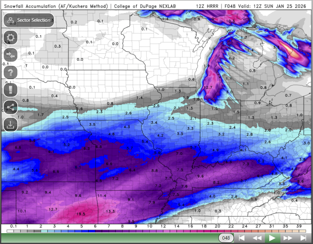
The 12z long-range HRRR is a thing of beauty. Would pay big bucks for this to verify, unlikely as that is

-
A perfect run showing how the NAM is always wetter and warmer than what verifies. Classic stuff.
-
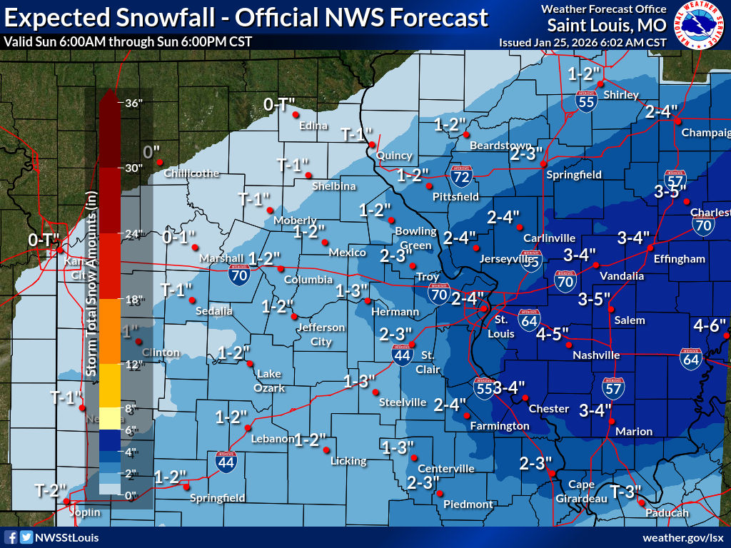
NWS STL finally getting fully onboard..
-
-
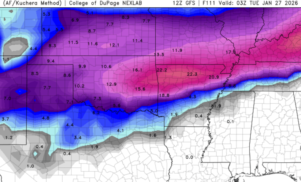
12Z GFS running and seems really similar to last run
-
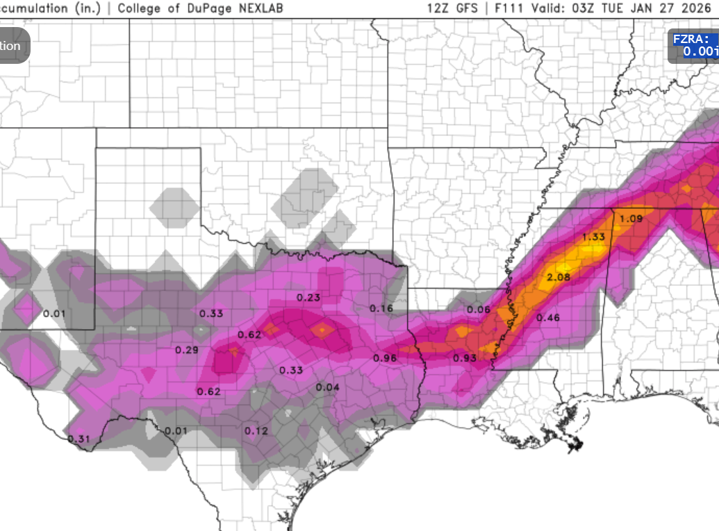
I imagine they are concerned with mixing to the south and east, but from Cape on north there isn't gonna be any mixing so the disparity is crazy.
-
NWS STL hedging quite a bit
-
Yeah feels a lot more likely that the models will factor in the strong arctic high/blocking and how dry it is and create sharper northern cutoffs than there be a temp thing going on. The cold is legit.
-
1 hour ago, rockchalk83 said:
Another banger from the Euro:

Time to start the windshield wipers and bring this back south a little bit so everyone can get in on the fun.
-
We had about 2" of wet snow in the last system that melted/was washed away within hours. No advisory for that.
But they finally went ahead and gave us our first WWA of the season in SEMO for this one. A few flakes falling out there now.
-
I could complain that we didn't get more, but what's the point? A decent result here in southeast Missouri (about 6") and bitterly cold this morning.
-
Likely going to score a quick inch this morning here in SEMO before the main event.
-
10 minutes ago, ouamber said:
The NAM is much farther north. When should we pay attention to it?
Well since it completely plasters my backyard I would say now
-
 1
1
-
-
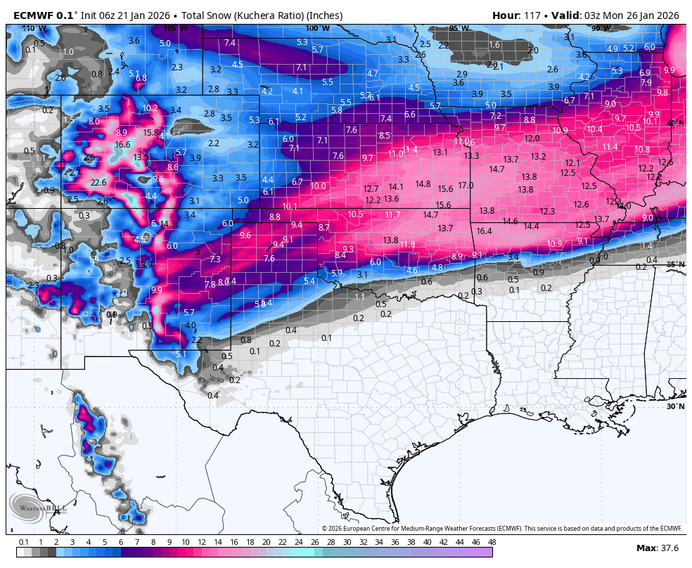
A foot of pure powder IMBY according to the 18Z GFS (Kuchera)
I would gladly take half of that!
-
This is a
 forecast if I've ever seen one for next Tuesday..
Cloudy with snow showers becoming a steady accumulating snow later on. Very cold. High 16F. Winds NNE at 10 to 15 mph. Chance of snow 80%. Snow accumulating 3 to 5 inches. -
This is real #LOCKITIN stuff right now
-
I will absolutely have what the 12Z GFS is having for next Tuesday.
-
29 minutes ago, SomeguyfromTakomaPark said:
Radar looks fantastic for New Orleans
They might be on course for the record
-
 1
1
-
-
Got family in north Florida. No way that Kuchera map verifies for Duval/St Johns county.. right?!
-
 1
1
-
-
12z GFS today still likes a storm next Thursday. And then gets wacky around 300hr with an absolute bomb
-
18z GFS is wild for next week.
-
1 hour ago, Benjamn3 said:
It will over perform.
I’m doing what Oprah said and speaking it into existence.
There have been no disappointments in the other regional boards so far. Even the despondent Midwest folks who have been hosed so far this winter are slightly happy!
Here in SEMO we're on course for at least 6" IMBY. Maybe 7 as it keeps trucking as I post this.
-
4
-
-
Yeaaah that's the good stuff man. Nice.
Definitely cleared the bar here and the warning criteria materialized. Probably 6" in the end. Still light-to-mod snow out there. 31F. Calm winds. Gorgeous.
-
33 minutes ago, StormChazer said:
Is it too soon to be talking about this already?
The big 3 are all sniffing something next weekend.


This one seems like big boom/bust potential. Signal is there but of course the track is what is gonna matter most. For sure going to be COLD again behind it. Would be a shame to lose all this snowpack when the temps get into the upper 40s next Thurs/Fri and then get 33F, cold rain.. followed by single-digit lows.
-
1
-
MO/KS/AR/OK 2025-2026 Winter Discussion
in Central/Western States
Posted
Windchill is already subzero here in SEMO. Extremely dry though.