Arctic Oscillation Now Diving...
This morning, the Arctic Oscillation (AO) stood at -1.956. Strong to possibly severe blocking that had persistently been modeled appears now to be developing. If some of the ensemble members are right, the AO will likely fall below -3.000 during this blocking episode. Some ensemble members take the AO below -4.000.
Severe blocks that commence in late November/early December can be long-lived. Notable long-lived blocks have developed in that timeframe following a blocky October. In other words, the blockiness that was present in mid-Autumn reasserted itself during the winter.
Recent examples include the blocking regimes of 2009-10 and 2010-11. The following severe blocking episodes (minimum AO value of -3.000 or below) began in late November/early December (11/20-12/10) following a blocky October (monthly AO of -025 or below):
December 7, 1966-January 11, 1967: 36 days
December 7, 1981-January 12, 1982: 37 days
November 29, 2009-January 15, 2010: 48 days
December 3, 2010-January 15, 2011: 44 days
In contrast, the severe blocks that developed during the same timeframe, but did not follow a blocky autumn (neutral or positive AO) were often shorter-lived. In cases, they were more an anomaly in a longer-term pattern that featured less blocking. However, some of those patterns eventually became blocky. Winters 1977-78 and 1995-96 were examples.
Those blocks were:
December 4, 1958-December 27, 1958: 24 days
December 6, 1961-December 13, 1961: 8 days
December 2, 1977-December 11, 1977: 11 days
December 3, 1989-December 21, 1989: 19 days
December 5, 1995-January 8, 1996: 35 days
December 6, 1996-January 12, 1997: 38 days
November 27, 2001-January 1, 2002: 36 days
Using all 11 cases, one finds:
Mean duration: 30.5 days (standard deviation: 13.1 days)
Median duration: 36.0 days
Less than 7 days: 0/11 (0%) cases
Less than 14 days: 2/11 (18%) cases
20 days or longer: 8/11 (73%) cases
30 days or longer: 7/11 (64%) cases
40 days or longer: 2/11 (18%) cases
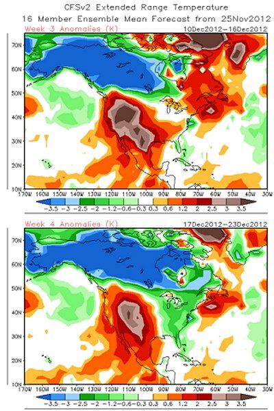
Given the development of what might be long-lived blocking, the evolution of a colder regime across the eastern third or even eastern half of the U.S., as well as southern Ontario and southern Quebec appears likely down the road. The transition could occur during the second week of December.
In its most recent weekly data, the CFSv2 is now showing this transition:

In the meantime, beginning Wednesday, a 5-7-day siege of precipitation is poised to inundate the Pacific Northwest. With the extreme precipitation figures modeled and the long-duration involved, this event is likely to be one of the highlight events of late fall 2012-winter 2013.


Recommended Comments
There are no comments to display.
Create an account or sign in to comment
You need to be a member in order to leave a comment
Create an account
Sign up for a new account in our community. It's easy!
Register a new accountSign in
Already have an account? Sign in here.
Sign In Now