


Pattern Change Now Evolving as Panic of December '12 Rises...
The storm that brought record daily snowfall to Minneapolis-St. Paul commenced a sequence of events that is leading to a pattern change. That sequence of events will likely include several systems (one underway and one or two others in coming days) that will be noted more for wet than white in the East. Afterward, the last 10-14 days (14 days for the Plains States and 10 days for the East Coast) could see generally cooler than normal weather.
The rising panic that Winter 2012-13 is becoming a repeat of the non-Winter of 2011-12 has resulted for a large gap between the actual pattern change that is now imminent and expectations. The pattern change was likely to be slow with a fairly lengthy transition before sustained colder weather set in. Given the combination of an EPO+, PNA-, and persistent Arctic warmth, severe cold was not very likely for much or all of December. Expectations were for prolonged and deep cold to set in with the potential for excessive snows. That gap was unsustainable, hence the rising panic.
If one steps back to take a look at the non-Winter of 2011-12, one finds:
1. A powerful AO+ regime predominated in December.
2. The long-range guidance and analog cases were unrelenting with their warm idea.
3. The subtropical jet was quiet.
To date, one finds:
1. A persistent AO- regime.
The AO has now been negative for 22 consecutive days. It is likely to remain predominantly negative for the remainder of the month as per the ensemble guidance and also historic cases. Notable long-lived blocks that developed in the 11/20-12/10 timeframe have typically been long-lived. Put another way, the blockiness that was present in mid-Autumn reasserted itself during the winter.
Recent examples include the blocking regimes of 2009-10 and 2010-11. The following severe blocking episodes (minimum AO value of -3.000 or below) began in late November/early December (11/20-12/10) following a blocky October (monthly AO of -025 or below):
December 7, 1966-January 11, 1967: 36 days
December 7, 1981-January 12, 1982: 37 days
November 29, 2009-January 15, 2010: 48 days
December 3, 2010-January 15, 2011: 44 days
All four of those cases saw the January AO average < 0. KU snowstorms occurred during the winter in 1966-67, 2009-10, and 2010-11. A KU snowstorm occurred during the spring in 1981-82,
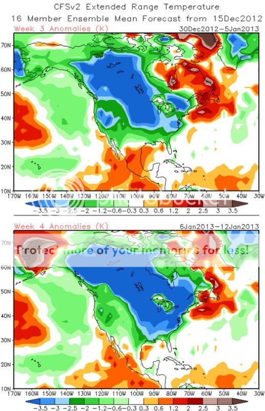
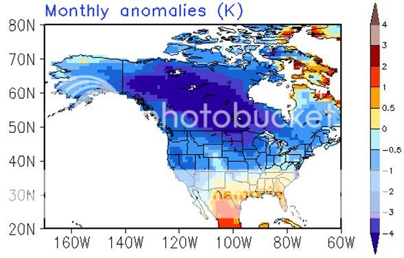
2. The long-range guidance has been anything like last winter. In fact, the latest CFSv2 guidance has trended toward widespread cold to begin January and a generally cold month across much of North America. With the PNA having been negative for 41 consecutive days, both historic cases and some ensemble members suggest that it could go positive near or during January. Once that happens, the dam that has kept some of the coldest air bottled up in Alaska and westward could break and a genuine prospect of at least an outbreak of severe cold could develop.
Below are the latest CFSv2 weekly (weeks 3 and 4) and monthly (January 2013) forecasts:
3. The SOI has recently gone negative. December 10-12 had values below -40. The 30-day moving average has gone negative and the 90-day moving average is near 0. Often such developments suggest a stronger subtropical jet. Hence, there is a possibility that the closing 10 days of December and perhaps the opening 10 days of January could be stormy.
In sum, the gradual pattern change is unfolding. At first, the cold will be a little more impressive than seasonal cold. Storminess could increase as well. The possibility of an outbreak of severe cold could increase after the start of January, as the PNA heads to more neutral values,and especially if it goes positive. All said, even as the first two weeks of December have been sufficiently warm to rekindle nightmares of the non-Winter of 2011-12, there are big differences that argue against a repeat.
Recommended Comments
There are no comments to display.
Create an account or sign in to comment
You need to be a member in order to leave a comment
Create an account
Sign up for a new account in our community. It's easy!
Register a new accountSign in
Already have an account? Sign in here.
Sign In Now