


The AO is forecast to drop to between -4 and -3 around the 3/20-24 timeframe, while the PNA is forecast to go weakly negative. The 500 mb anomalies associated with those teleconnections for the second half of March is shown below:
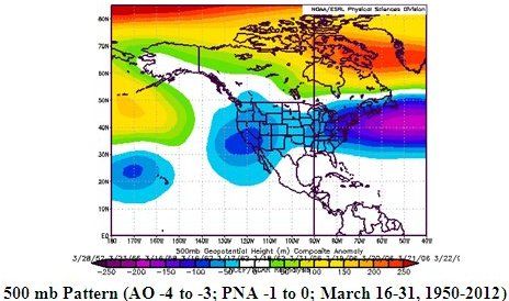
In terms of winter weather threats, there were 6 years that saw such an AO-PNA combination since 1950. 50% saw at least some measurable snow in Boston and New York City in the period running from 5 days before to 5 days after that combination; 33% saw some measurable snow in Philadelphia; and, 17% saw some measurable snow in Washington, DC. There was one KU snowstorm during those years (the March 1958 storm).
In short, even as climatology becomes increasingly tilted against snow in the Mid-Atlantic and New England areas, the kind of pattern forecast on the ensembles suggests higher than climatological potential for at least some snowfall. Favored regions would be the northern Mid-Atlantic and New England areas. That's not anything close to a certainty, but at least there's some potential on the table. One can't say that for most years and it is a marked contrast from last March when the "summer in March" episode lay just ahead.
Recommended Comments
There are no comments to display.
Create an account or sign in to comment
You need to be a member in order to leave a comment
Create an account
Sign up for a new account in our community. It's easy!
Register a new accountSign in
Already have an account? Sign in here.
Sign In Now