Albedoman
-
Posts
1,186 -
Joined
-
Last visited
1 Follower

About Albedoman

- Birthday 12/20/1958
-

E PA/NJ/DE Spring 2025 Obs/Discussion
Albedoman replied to PhiEaglesfan712's topic in Philadelphia Region
Mike Gorse, fwiw,--the current point forecast for Ancient Oaks in Lehigh County does not display the current flood warning- strangeIt maybe because Its for Perkiomen stream only and not the Little lehigh. I guess Thanks -
E PA/NJ/DE Spring 2025 Obs/Discussion
Albedoman replied to PhiEaglesfan712's topic in Philadelphia Region
https://water.noaa.gov/gauges/trep1 -
E PA/NJ/DE Spring 2025 Obs/Discussion
Albedoman replied to PhiEaglesfan712's topic in Philadelphia Region
2.25 inches of rain at my house - Spring Creek is at flood stage and rising quickly. Been a long time since we have reached flood stage. Yes I will declare this drought over guys at this time. These long duration rains are now bringing up the base flows of the streams. Corn is coming up nicely in my area of Lehigh County. If the farmer is trying to plant it now, it could be a loss. The loss however is not just the rain but with the extreme cooler temps. Usually by now, we have temps in the mid to upper 80's with a few days of 90's. In fact, we maybe back in the 40's for overnight lows and highs only in the upper 60's for June 1 ------ Coolest I have seen for us in June but it does save on the AC bills. But after Wednesday, we go back into the oven. Watch the mold counts grow big time. -
E PA/NJ/DE Spring 2025 Obs/Discussion
Albedoman replied to PhiEaglesfan712's topic in Philadelphia Region
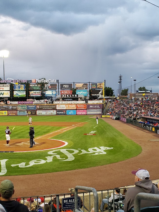
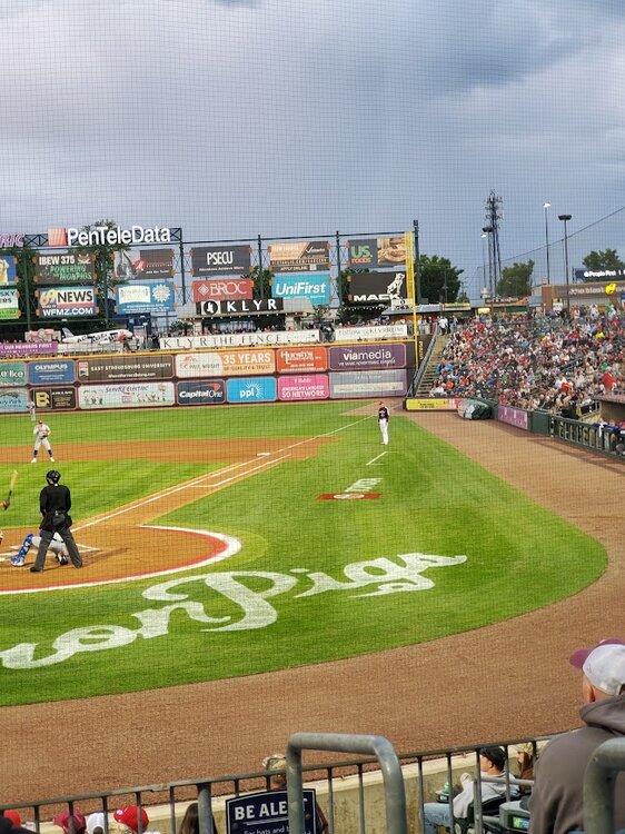
I attended the Iron Pigs game last night. Cold unstable air mass showers popping up throughout the game. Observed three rainbows with one of them being a double rainbow. However, if you look directly over the US foods advertising board, in these photos in right field, there appears to be a cold air funnel forming with the cold unstable air mass in place. I would like Mike and his team to look at these photos for verification. It did not appear to be a simple rain shaft but actually appeared to have rotation and looked like a funnel. If this was indeed a cold air funnel, this would be extreme for our area but I would not doubt its formation with this very cold unstable air mass above in late May.
-
E PA/NJ/DE Spring 2025 Obs/Discussion
Albedoman replied to PhiEaglesfan712's topic in Philadelphia Region
LMAO- Guess its time to change my alias to flood guy now -
E PA/NJ/DE Spring 2025 Obs/Discussion
Albedoman replied to PhiEaglesfan712's topic in Philadelphia Region
Thanks Mike I should have said "possible" left out the word. Sorry. It appears to be an EF0 after looking at the tree damage video more closely but FWIW to shear of tree tops and twist them like that would have easily destroyed a home if the funnel actually reached the ground and was not over a forested area, which why I said a possible EFI . -
E PA/NJ/DE Spring 2025 Obs/Discussion
Albedoman replied to PhiEaglesfan712's topic in Philadelphia Region
well even though Macungie got zilcho rain from this storm, Bangor area in Northampton County got hail and an EF1 tornado that was on video. Tree tops sheared right off and twisted (not straight line wind damage) and no doubt that it was a tornado with hail from this very localized supercell -should have chased that one down. Mt holly storm damage specialists I am sure will out there to inspect tomorrow. https://www.wfmz.com/weather/it-took-out-almost-every-tree-on-my-property-tornado-touches-down-in-northampton-county/article_8f50d7e4-d6a2-4ae0-9709-dd23a3a73bc7.html#tncms-source=More-from-newsroom-(right-column) -
E PA/NJ/DE Spring 2025 Obs/Discussion
Albedoman replied to PhiEaglesfan712's topic in Philadelphia Region
nothing but sprinkles here today in Macungie. Missed everything. Total four day is .46 in---- Storms to the west and east and we got the 4-10 split. Well better luck next time. When are we ever going to have a decent NW to SE squall line come through? Everything is hit and miss in our region I literally cannot remember when a squall line preceded a cold front as so many squall lines have went ---poof ---before hitting the Blue Mts. -
E PA/NJ/DE Spring 2025 Obs/Discussion
Albedoman replied to PhiEaglesfan712's topic in Philadelphia Region
absolutely agree. Forecast models have continually failed with wind speed and direction since last year. The LR and even the SR computer models need to be calibrated to not just look at temps and precip atmospheric profiles and soundings but should consider the most critical feature- the role of surface topography and overall natural physical geography of our area. For example when a SE to S direction fetch of wind is prevalent for hours or days, the models should compare the geography of the area and bias should be added for chances of higher precip values(especially in training t-storms or froneneis for snowfall predictions ) in certain regions of the entire forecast area for MT Holly. The same goes with a direct east wind in which literally prevents t storms from from the west to cross over the Blue Mts. Physical Geography features plays a vital part in local forecasting for our area and atmospheric modeling needs to be vastly improved to include and or be more accurately biased when using pin point forecasting, especially with wind direction speed for upsloping and downsloping of the mountain ranges and deeper valleys. Simplistic terms- need a better algorithm for physical geography features rather than just using transportation networks to identify different forecasts for different aras. Thats why Macungie to Huffs Church area are constantly having inaccurate forecasting for either high or low temps and or precip values and types because the pin-point forecast do not include the topography for S Mtn range as a dividing line for precip or for different forecasts. Everything is now based on I-78, I-80 and PA turnpike transportation areas when formulating and discussing the local forecasts. IMHO, MT Holly /NOAA needs to reconsider relying more on physical geography/topography when discussing LV forecasts and not just referring to major transportation networks. FWIW, transportation networks literally bore through local mountain ranges by tunnels or by steep climbing lanes and built to go in different directions. I -78 is a perfect example of how dividing forecast areas is incorrect as it goes from SW to NE and then goes directly E to West. It literally bisects the S Mt Range in the heart of the LV. The NE turnpike is a N to S directional road which is usually only brought into the picture on types of winter precip or from storms along the coast--- yet both of these highways go through the heart of the LV.. Hopefully you see the problem of using transportation networks as delimiting line for producing local forecasts in the LV. Best examples of my reasoning- how many times have you personally gone through the Lehigh Tunnel and on one side it is snowing and the other side it is clear? How many times have you gone on RT 29/Rt 100 through Shimerville or Huffs Church and it has 2 in of snow on the ground but you get to the Macungie and Emmaus and or East Greenville and it is raining? Physical Geography plays a vital part in weather forecasting and personally believe not enough attention has been given to this fact based on our vast local regional forecasting area that MT Holly must cover. This is not the fault of the MT Holly staff at all but federal govt decisions made back in the early 90's to do away with the Allentown weather forecast office at LVIA. This was a huge mistake and I was against this change but it was a lost cause. The politicians simply did not care or understand the role of physical geography has on the the LV . That is why I am so outspoken at times about the LV. The "fall Line"" basically stops at S MT range and any thing north of that that is also in a valley which has very unique weather forecasting difficulties such as extreme diurnal and nocturnal temp ranges from the deeper valleys especially with upsloping and downsloping conditions in major storm events including wind storms, fog, freezing rain and even snow accumulations. LV is unique. -
E PA/NJ/DE Spring 2025 Obs/Discussion
Albedoman replied to PhiEaglesfan712's topic in Philadelphia Region
-
E PA/NJ/DE Spring 2025 Obs/Discussion
Albedoman replied to PhiEaglesfan712's topic in Philadelphia Region
I agree. From 2-4 inches to less than an inch for the LV and points north. I received a whopping .02 more rain than you today. Hell, the new small leaves on the trees kept the street dry. There were more pollen sacs in the street from last nights gusty winds and brief heavy shower that I thought the township could bring out the plow. Training of t storms is not in the cards anytime soon. -
E PA/NJ/DE Spring 2025 Obs/Discussion
Albedoman replied to PhiEaglesfan712's topic in Philadelphia Region
No way does even 2 in even verify today. Absolutely no training of t storms. Air is too stable and too dry. Just enough rain to keep the pollen down today. I only had a .40 inch of rain yesterday- very localized. 2 day total --.70 inch of rain. Still no drought buster rains for sure but it does help the garden. -
E PA/NJ/DE Spring 2025 Obs/Discussion
Albedoman replied to PhiEaglesfan712's topic in Philadelphia Region
-
E PA/NJ/DE Spring 2025 Obs/Discussion
Albedoman replied to PhiEaglesfan712's topic in Philadelphia Region
thundershower with gusty winds 25-30 mph now. Not severe but a nice t shower Need much more. -
E PA/NJ/DE Spring 2025 Obs/Discussion
Albedoman replied to PhiEaglesfan712's topic in Philadelphia Region
holy crap a cell made it over the Blue Mts. I may actually experience a thundershower in the next 30 minutes. Its in eastern Berks near Kutztown. C'mon baby my air needs to cleaned out of pollen and the pollen cement dust needs to goo bye bye off my car.