

SmokeEater
-
Posts
10,000 -
Joined
-
Last visited
Content Type
Profiles
Blogs
Forums
American Weather
Media Demo
Store
Gallery
Posts posted by SmokeEater
-
-
Day 1 enhanced with a large 10% hatched tor.
Sent from my SM-S901U using Tapatalk -
.
Sent from my SM-S901U using Tapatalk-
 1
1
-
-
The 0z HRRR is well.... Bad....
Sent from my SM-S901U using Tapatalk -
If it's not in NC/SC or GA they usually could care less, half the time it ends up in another forum usually anyway.I started a thread in the Southeastern sub. Whether it gets any traction over there is another story. I wonder if MS and AL should be adopted by the Central forum lol.
Sent from my SM-S901U using Tapatalk
-
 1
1
-
-
This isn't a crazy event by any means, but I really hope it works out for you N&W guys, I'd gladly take one for the team this winter for that to happen.
Sent from my SM-G973U using Tapatalk-
2
-
 2
2
-
-
We're gonna end with around a foot here, no way can I measure accurately, I've got some almost bare spots, and some drifts to knee high. Awesome storm, glad the rest of the forum got some ok amounts out of it too.
Sent from my SM-G973U using Tapatalk-
1
-
-
Gotta be at least 4, haven't had a chance to measure, just eyeballing it. Don't know if we'll verify out on this end, but the barrier islands I think definetly will.Enjoy man! Curious to see if your blizzard warnings end up verifying. How much do you think you have so far?
Sent from my SM-G973U using Tapatalk
-
Roaring down here even in W Atlantic right now, wind picking up also, SWS just issued. Buddy in OC is getting at least 2 inch an hour rates.
...Heavy snow and increasing winds are expected to produce rapidly deteriorating conditions during the overnight hours...
At 1220 am, radar indicated a band of heavy snow extending from Caroline County in Maryland and Sussex County in Delaware north-northeast to Monmouth County in New Jersey. Spotters and the public have reported heavy snow rates with this band, exceeding one to two inches per hour. The band is nearly stationary, suggesting that heavy snow accumulations are likely in this corridor during the overnight hours. Additionally, a second band of heavy snow appears to be developing near the southern New Jersey coast. Winds have increased considerably along the coast in the past couple of hours, with reductions in visibility to a half mile or less in several spots. Blizzard conditions are likely to develop in the next few hours in these areas, with severe reductions in visibility and nearly impossible travel conditions.
Travel is strongly discouraged in southern New Jersey, central and southern Delaware, and northeast Maryland through the morning hours. If you must travel, bring a winter survival kit. If you become stranded, stay with your vehicle.
Sent from my SM-G973U using Tapatalk-
4
-
 1
1
-
-
Now we see how the wind event pans out down here.
Sent from my SM-G973U using Tapatalk-
1
-
-
Flipped over to rain here in Western Atlantic County, dusting on the ground, that's about it.
Sent from my SM-G973U using Tapatalk-
1
-
1
-
-
All of SJ except for the Cape upgraded to a WSW.
Sent from my SM-G973U using Tapatalk -
Accidents all over SJ too, too many to count at this point.
Sent from my SM-G973U using Tapatalk-
1
-
-
Temp quickly dropping here in interior Atlantic County, down to 45 degrees with 20 mph gusts.
Sent from my SM-G973U using Tapatalk-
1
-
-
WSW out for Atlantic, Cumberland and Cape May Counties, at least 4-6 possible. This is getting very interesting, very fast.
Sent from my SM-G973U using Tapatalk-
1
-
-
Cell just SE of Starkville, MS really trying.
Sent from my SM-G973U using Tapatalk-
1
-
-
New watch out for MS, AR, LA, 70/50 probs, mentions discrete supercells.
Sent from my SM-G973U using Tapatalk -
Structural damage in downtown Winfield, AL from a tornado about 90 minutes ago.
Sent from my SM-G973U using Tapatalk-
1
-
-
Check again man, now back to EF3 with no wind speed.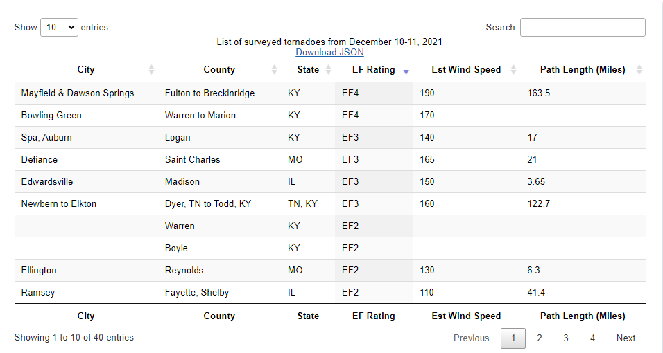
Sent from my SM-G973U using Tapatalk
-
Actually not EF4 now, somebody behind the scenes messed up. NWS Louisville themselves are actually calling people out on social media who shared it, saying it's false information.Bowling Green KY tornado has been upgraded to EF4 per NWS CRH.
Sent from my SM-G973U using Tapatalk
-
Confirmed tornado near Plainview, MN.
Sent from my SM-G973U using Tapatalk -
Check WEHT.Any good local news sources for the storm as it heads towards Madisonville? It's moved out of the KFVS viewing area so they're dropping coverage
Sent from my SM-G973U using Tapatalk
-
1
-
-
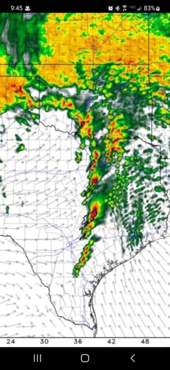
200+ kts G2G as we speak, Jesus.
Sent from my SM-G973U using Tapatalk -
I haven't felt like this since that night.....I feel like I’m watching Greensburg all over again
Sent from my SM-G973U using Tapatalk
-
Pray guys, pray hard. Mayfield is about to get destroyed.

Sent from my SM-G973U using Tapatalk

3/17/2022, 3/21/2022 & 3/22/2022 Severe Weather, Major Tornado Damage in New Orleans
in Central/Western States
Posted
Upgrade to moderate for hail, they even mention tornado risk remains mostly unchanged.
Sent from my SM-S901U using Tapatalk