

SmokeEater
-
Posts
10,000 -
Joined
-
Last visited
Content Type
Profiles
Blogs
Forums
American Weather
Media Demo
Store
Gallery
Posts posted by SmokeEater
-
-
We already want to, lol. Hilarious how many times after that event the state has brined roads with sun forecasted.Know what a disaster it would be in NJ after the November debacle, they would run the mayor to the gallows
Sent from my SM-G950U using Tapatalk
-
Snowing lightly just to your west in Folsom, it's coming man.Nothing here in Mays Landing. Virga
Sent from my SM-G950U using Tapatalk
-
Ji seems genuinely enraged its not a KU, at least he was 1-2 days ago, lol. Forget that man, I'm just happy to see the ground white. Pattern is ripe going forward.Whatever happens here so be it but you have to be happy for our folks to the S (Balt/MD etc)...they get shafted year after year. Surprised no one has committed suicide in that subforum....or have they? Not sure...
Sent from my SM-G950U using Tapatalk
-
I'm going to do the same here also, probably take a ride down to the Cape Sunday morning, depending on how this sets up. I'll take even 1-3 in Atlantic Co and run with it being I completely missed the norlun trough down here because I was at work in North Jersey and not a flake fell.I'm heading down to Atlantic City for the weekend but will likely play around in Cape May County tomorrow morning. I think they will get a nice 6 inch snowfall out of this. Mt Holly on the fence as well.
Sent from my SM-G950U using Tapatalk
-
Finished with 4 inches in Folsom, Atlantic County, more to my east. Didn't get to see a flake of it fall since I was in North Jersey for work, was weird, it's usually the opposite, lol.
Sent from my SM-G950U using Tapatalk-
 1
1
-
-
Was 130 kts G2G last scan too.There has to be a monster north of Natchitoches. Thing has a legit donuthole on the reflectivity, usually only seen with strong tornadoes
Sent from my SM-G950U using Tapatalk
-
Not a good sign these are discrete and producing so fast.
Sent from my SM-G950U using Tapatalk -
That's confirmed, off Holabird Ave. Possibly one unaccounted for.Seems that there is a building/roof collapse at the Amazon Facility in Baltimore.
Sent from my SM-G950U using Tapatalk
-
K thanks, was out to dinner and didn't see it.It was... LWX issued a STW at 8:26pm until 9:15pm and it included Carroll County
Sent from my SM-G950U using Tapatalk
-
71 mph gust reported by a spotter in NE Carroll County. It wasn't warned?
Sent from my SM-G950U using Tapatalk -
From BMX's AFD for Monday into Tuesday. Very, very bullish. Make a thread in here, or SE?
The shortwave on Sunday night will serve as a primer wave for the next system developing to our west on Monday. A wide area of rich moisture will be lurking near the Gulf Coast, poised to move inland Monday afternoon and evening as wind fields respond to a shortwave entering the Southern Plains. Models are coming into agreement on a potentially dangerous setup Monday night into Tuesday morning across a large area which includes Alabama. The GFS and ECMWF are in good agreement with the evolution of the synoptic pattern, showing a low-amplitude shortwave taking on a negative tilt Monday night to our northwest. This pattern has the look of a classic severe weather outbreak and would support a rapidly deepening surface low tracking toward the Great Lakes with significant pressure falls extending southward into Alabama. With dewpoints rising into the upper 60s to perhaps 70F, instability appears more than sufficient for deep convection within a very highly sheared environment. Taken at face value, the ECMWF shows semi-discrete supercells capable of producing long-track, significant tornadoes across the northern half of our forecast area on Tuesday morning. The HWO will be updated to include a moderate confidence threat for tornadoes and damaging winds across the entire forecast area. With this threat still around 96 hours out and models subject to change, we will refrain from going all in on the potential for a tornado outbreak.
Sent from my SM-G950U using Tapatalk-
1
-
-
Now reported all 215 have been located.
Sent from my SM-G950U using Tapatalk -
Supposedly a church group of 200 people went out on rafts today, possibly up to 50 still missing. Whoever approved it needs to be put away....Just heard something about rafters and search parties on Lehigh river? Anyone know about this?
https://wnep.com/2018/08/13/search-for-missing-rafters-on-lehigh-river/
Sent from my iPad using Tapatalk
Sent from my SM-G950U using Tapatalk
-
Possibly one of the most textbook signatures I've ever seen.

Sent from my SM-G950U using Tapatalk-
1
-
-
Large TOG about to move into Melvin, IA.

Sent from my SM-G950U using Tapatalk -
PDS warning on it.
Sent from my SM-G950U using Tapatalk -
Still on the ground heading for Gaylord, MN. FD reporting 3 tornadoes on the ground coming out of Nicollet County.
Sent from my SM-G950U using Tapatalk -
Confirmed on the ground now.
Sent from my SM-G950U using Tapatalk -
Looks like a TOG near Nicollet, MN, strong couplet with CC drop. CC was bigger last scan.

Sent from my SM-G950U using Tapatalk -
4 minutes ago, andyhb said:
That big one was down for at least half an hour unless it cycled in between scans. Certainly not something I saw coming today, but favorable low level winds can lead to strange things when combined with 2500 J/kg MLCAPE. Noteworthy that the 500 mb flow was only around 15 kts in the area where this cell set up shop.
You and a ton of chasers, lots of implosions on FB tonight.
-
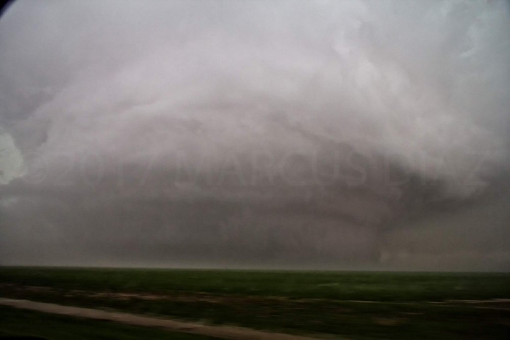
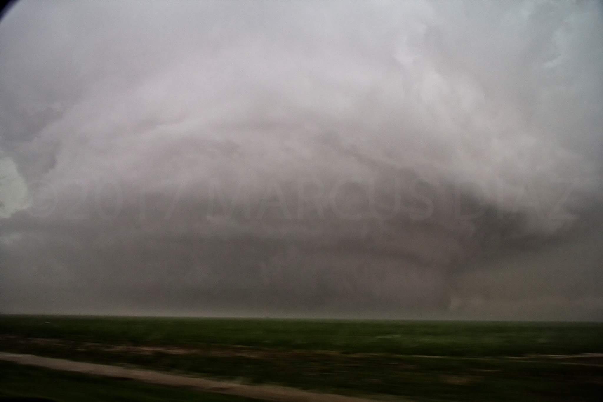
The monster, pic from Marcus Diaz. Whole damn meso is on the ground.
-
1
-
-
I just started looking at radar, and I can only grab data that is less than 1 hour old. Did the storm cycle, and produce a 2nd tornado southwest of the original? Not sure. Pretty incredible radar images.
It's produced many tornadoes, some up to a mile wide. Insane storm. -
Looks like it's cycling, new circulation is forming SW.
-
Day 1 enhanced to start, main threat large hail with a couple tornadoes 5/15/30 hatched for hail.
Jan 12-13 Snow Event Obs and discussion
in Philadelphia Region
Posted
Everything covered here now, all roads too. Heading to bed, we'll see what the overnight brings.
Sent from my SM-G950U using Tapatalk