

J.Spin
-
Posts
6,157 -
Joined
-
Last visited
Content Type
Profiles
Blogs
Forums
American Weather
Media Demo
Store
Gallery
Posts posted by J.Spin
-
-
We’ve got a bit of light snow falling now, but with nothing on the radar, the small size of the flakes, and the low clouds comments about in the BTV NWS forecast discussion, I suspect it’s from low-level moisture.
National Weather Service Burlington VT
635 AM EST Mon Dec 27 2021
NEAR TERM /THROUGH TUESDAY/...
As of 627 AM EST Monday...Low clouds continue to blanket much of the forecast area this morning, with some open patches seen in the St Lawrence Valley, Adirondacks, and south-central VT. However, mid/high cloud are spreading into northern NY ahead of our next system, so even if the low clouds are able to dissipate, don`t anticipate there will be much sun.
-
Event totals: 1.9” Snow/0.22” L.E.
We’re just cloudy now, and there’s nothing of note on the radar, so I’d say this is the end of this system and the totals above are final for the storm. So it looks like this one contributed just shy of ¼” of liquid equivalent going into the snowpack. The BTV NWS forecast discussion indicates that the next system is expected to move into the area tonight into tomorrow.
Details from the 6:00 A.M. Waterbury observations:
New Snow: 0.3 inches
New Liquid: 0.02 inches
Snow/Water Ratio: 15.0
Snow Density: 6.7% H2O
Temperature: 23.0 F
Sky: Cloudy
Snow at the stake: 5.5 inches
-
Event totals: 1.6” Snow/0.20” L.E.
Details from the 8:00 P.M. Waterbury observations:
New Snow: 0.5 inches
New Liquid: 0.02 inches
Snow/Water Ratio: 25.0
Snow Density: 4.0% H2O
Temperature: 26.2 F
Sky: Light Snow (2-20 mm flakes)
Snow at the stake: 5.5 inches
-
25 minutes ago, mreaves said:
26° and a little light snow falling. Just chopped my car out of it’s icy tomb from yesterday and bombed the snowmobile around the yard. Much more wintry than last year at this time. Hopefully we can add a little this week.
You can really see that snow pushing in on the radar; classic flow from the northwest:

-
16 hours ago, mreaves said:
We were actually progressing along decently until winter took a 2 week break and we lost our starting base.
16 hours ago, STILL N OF PIKE said:I would guess it might be a bit more of a percentage deficit @ Spruce but I’ll ask PF.
17 hours ago, J.Spin said:We could use a bit of catching up of course, but there certainly are some systems in the modeling over the next week or two.
I was just looking through the modeling to see what’s lined up for the coming holiday week, and here are the latest suggestions for storms:
· Today through tomorrow morning – the backside/upslope potion of this most recent system. In their AFD, the BTV NWS mentions 1-3”, and I see roughly 2-4” in the Mansfield point forecast.
· Tomorrow night-Tuesday – a weakening shortwave with a chance for snow showers
· Tuesday night-Wednesday – another possible system with light precipitation
· Thursday into Friday – a weak low pressure system that seems to be blending with the previous one on some guidance.
· Saturday night onward – a potential larger system
None of these are expected to be anything major aside from that larger one that’s fairly far out there, but as usual up here, the pattern is pretty active with chances to freshen the slopes and have flakes in the air. After the first couple of systems, these events are certainly in flux, but we’ll see how it sorts out to bring snow. Whatever the case, it’s nice to be topping off the slopes during the holiday week vs. recovering from some huge storm where the area lost a lot of snow because we were in the warm sector.
-
Event totals: 1.1” Snow/0.18” L.E.
Details from the 6:00 A.M. Waterbury observations:
New Snow: 0.4 inches
New Liquid: 0.03 inches
Snow/Water Ratio: 13.3
Snow Density: 7.5% H2O
Temperature: 26.2 F
Sky: Light Snow (1 mm flakes)
Snow at the stake: 5.0 inches
-
Event totals: 0.7” Snow/0.15” L.E.
Details from the 12:00 A.M. Waterbury observations:
New Snow: 0.4 inches
New Liquid: 0.04 inches
Snow/Water Ratio: 10.0
Snow Density: 10.0% H2O
Temperature: 28.0 F
Sky: Light Snow (1-4 mm flakes)
Snow at the stake: 5.0 inches
-
I hadn’t looked outside for a while, but I just looked out and noticed that the deck had whitened up quite a bit more from the grayish sleet color that had been accumulating, and the precipitation has changed over to all snow. We’ll have to see if snow is going to predominate going forward, but many models indicate the chance for continued snow right through Monday morning.
-
9 minutes ago, STILL N OF PIKE said:
Is NNE running significantly below (for them ) averages so far for snow (N greens in particular ) . I have been checked out of weather for a while but also mostly Bc it’s been slow
Assuming the typical correlation between our site and the rest of the range, we’re certainly behind average pace, but not excessively so. PF can comment on where things stand for Mansfield if the usual correlation is off for any reason.
November was about average for snowfall, and the first ten days of December were on that same pace, then there was a lull for a week (first plateau on the curve below) before Winter Storm Carrie came through. We’ve hit another lull since then though. Here at the house, average cumulative season snowfall for this date is 40.4”, and we’re at 33.1”, but it’s well within one S.D. (± 19.0”).
We could use a bit of catching up of course, but there certainly are some systems in the modeling over the next week or two.

-
Event totals: 0.3” Snow/0.12” L.E.
This most recent stretch was definitely a lighter period of precipitation, with just 0.01” of liquid.
Details from the 6:00 P.M. Waterbury observations:
New Snow: Trace
New Liquid: 0.01
Temperature: 30.1 F
Sky: Freezing Drizzle
Snow at the stake: 5.0 inches
-
Event totals: 0.3” Snow/0.11” L.E.
Over the course of the morning we’ve seen mostly light sleet, with some freezing rain and what appear to be some small flakes as well. The accumulation on the boards was quite dense as one would imagine.
Details from the 12:00 P.M. Waterbury observations:
New Snow: 0.2 inches (Sleet)
New Liquid: 0.10 inches
Snow/Water Ratio: 2.0
Snow Density: 50.0% H2O
Temperature: 29.5 F
Sky: Sleet/Freezing Rain/Snow
Snow at the stake: 5.0 inches
-
Event totals: 0.1” Snow/0.01” L.E.
There was a tenth of an inch of accumulation on the boards at observations time this morning, which seemed to be a combination of sleet and some freezing rain. The precipitation since then has been a mix of sleet and freezing rain, but surprisingly, mostly sleet in the past half hour with some additional accumulation.
Details from the 6:00 A.M. Waterbury observations:
New Snow: 0.1 inches (Sleet)
New Liquid: 0.01 inches
Snow/Water Ratio: 10.0
Snow Density: 10.0% H2O
Temperature: 24.1 F
Sky: Sleet/Freezing Rain
Snow at the stake: 5.0 inches
-
11 hours ago, J.Spin said:
We’ll see what adjustments are done at the afternoon update...
It doesn’t look like there were any major changes in the thinking since this morning, but the Winter Weather Advisories were expanded a bit to the east, and the projected snow accumulations were brought down a bit for the BTV NWS coverage area. There’s till 4-6” of snow indicated along the peaks in the Northern Greens, and we’ll just have to see how the combination of front side snow, mix, and back side snow comes together. The latest BTV NWS maps are below:


-
I got an alert this morning that we’ve been put under a Winter Weather Advisory for the upcoming storm. The current forecast in this area suggests the system starts as snow, then incorporates some mixed precipitation the farther west you are, and then transitions back to snow. Forecasts for accumulations in the local elevations are generally in the 3-6”, with the larger portion of that on the back side vs. the front side. It should be a nice refresher with a modest addition of liquid equivalent for the local slopes either way, but we’ll have to see how much any mixed precipitation affects the quality of the conditions. We’ll see what adjustments are done at the afternoon update, but the current BTV NWS maps for this storm are below:


-
Event totals: 0.1” Snow/0.01” L.E.
We did pick up a bit of snow this afternoon, and the BTV NWS indicates that this wasn’t really from the coastal storm, but a weak, fast-moving wave coming through southern Canada.
Details from the 6:00 P.M. Waterbury observations:
New Snow: 0.1 inches
New Liquid: 0.01 inches
Snow/Water Ratio: 10.0
Snow Density: 10.0% H2O
Temperature: 30.4 F
Sky: Cloudy
Snow at the stake: 6.0 inches
-
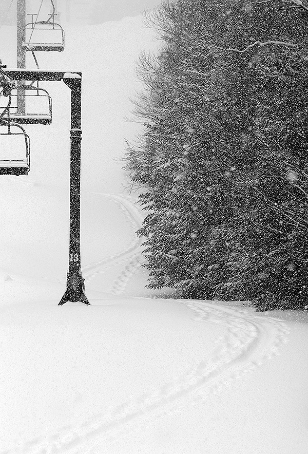
It’s been a busy past couple of days finishing up the semester, but we got out to the mountain on Sunday to take a few turns in the new snow from Winter Storm Carrie.
For conditions, there was about a half foot of new snow reported by Bolton in their morning report, although there were probably a couple more inches on top of that with the way it was accumulating while we were there. Indeed they’re now reporting 8 inches for their weekly total, and I’d say that’s probably the storm total once the backside snows were incorporated. It was a decent resurfacing of the slopes, with 0.80” of L.E. recorded here at our place. I suspect they’re in the that ballpark for L.E. as well, although the western slopes probably were a bit lower on storm totals relative to the eastern slopes with the flow for the majority of the storm cycle. In any event, surfaces were nice, although I could see how high-angle terrain or higher traffic resorts could be down to firm surfaces pretty quickly.
The overall feel at the resort was quite wintry with temperatures in the teens F, moderate snow falling, and some wind. Bolton only had their lower lifts running as they were still prepping the Vista Summit for lift-served levels of traffic, but it looks like this storm put them over the top and they’re opening the Vista Quad tomorrow. The Wilderness Uphill Route is open, so with the leftover base they had plus this new storm, there’s certainly enough snow to be skinning for turns on the natural snow terrain at Wilderness, so that’s great to have in place for the upcoming holiday period. They’ll still need another decent shot of liquid equivalent to get more terrain open for lift-served levels of traffic on natural snow terrain, and to get the lower-elevation Timberline area open for ski touring traffic. I’m sure there are some people touring down at the Timberline elevations, but the Timberline Uphill Route isn’t officially open yet. I think they’d lost most of the natural base snow there, so you’re working with just the accumulations from Winter Storm Carrie, and that one storm with ~3/4” of liquid equivalent isn’t quite enough to get touring into a really comfortable place.
A few shots from Sunday:


-
 4
4
-
-
22 minutes ago, mreaves said:
The BTV guys know their audience
"And if the trend is your friend, then snow people should be happy as this system has continued to trend towards a colder solution with conditional
probabilities for snow ranging from 70% across the broader VT valleys to 100% elsewhere."
Yeah, it’s not as is everyone in NVT and NNY is a snow fan, but the percentage of folks who live here because of the snow, combined with those who simply accept it as a fact of life in the far north, is probably much higher than what you’d find in the big cities of the megalopolis. Sure, there are weenie types in the big cities, many folks like a good snowstorm, and those absolute numbers are probably going to be larger in the big cities than here. But for most people, snow and cold in the big cities is just a headache, especially once you’re past the holidays. The BTV NWS has their general population, plus numerous major ski resorts, plus all the other winter recreation activities that go on here, plus the winter tourism, to think about. Not that many people in the general read the BTV NWS forecast discussions, but I wouldn’t be surprised if we have a larger “pro-snow” population in general than many areas. In the mountain/resort communities at least, a relatively high percentage of snow fans has got to be a slam dunk.
-
There was only a trace of snow at observations time this morning, but now the snowfall has picked up and we’re starting to get some measurable accumulation from this current system. The BTV NWS forecast discussion indicates that it’s a cold front coming through.
-
19 minutes ago, PowderBeard said:
I'm sure the NVT guys know more about this but I would imagine if MRG was closer in elevation to Mount Ellen there would be a similar effect, although there is a difference in orientation. I'd imagine there must be some events when Bolton or Smuggs get the goods over Stowe? @powderfreak@J.Spin
For the Northern Greens, I’ve found that Bolton or Smugg’s can pick up more in a storm than Stowe if there’s a very west side-favored event, since they’re the resorts on the more western side of the spine around here.
For the MRV portion of the Central Greens, one typically doesn’t see MRG outpace Sugarbush in many events – they really both do sit on the same (eastern) side of the spine, pretty much lined up next to each other. With the extra 400’ of elevation, occasionally one sees a bit of snowfall preference in the reverse direction, but it’s probably more a function of snow measurement timing/methodology in many cases.
-
1
-
-
Event totals: 9.3” Snow/0.80” L.E.
After another 0.4” overnight, we’ve mostly cleared out now, so I’d say this system is complete and the above values are the final numbers at our site for Winter Storm Carrie.
Details from the 6:00 A.M. Waterbury observations:
New Snow: 0.4 inches
New Liquid: Trace
Temperature: 4.1 F
Sky: Partly Cloudy
Snow at the stake: 7.5 inches
-
Event totals: 8.9” Snow/0.80” L.E.
Details from the 12:00 A.M. Waterbury observations:
New Snow: 0.7 inches
New Liquid: 0.01 inches
Snow/Water Ratio: 70.0
Snow Density: 1.4% H2O
Temperature: 14.4 F
Sky: Light Snow (2-15 mm flakes)
Snow at the stake: 8.0 inches
-
I’ve got the north to south listing of available snowfall totals from the Vermont ski areas for Winter Storm Carrie thus far. Based on the reports, there certainly seemed to be a bit of a local accumulations peak in the Middlebury-Killington stretch
Jay Peak: 9”
Burke: 7”
Smuggler’s Notch: 8”
Stowe: 5”
Bolton Valley: 6”
Sugarbush: 7”
Middlebury: 8”
Pico: 11”
Killington: 11”
Okemo: 6”
Bromley: 4”
Magic Mountain: 5”
Stratton: 6”
Mount Snow: 4”
-
Event totals: 8.2” Snow/0.79” L.E.
Details from the 6:00 P.M. Waterbury observations:
New Snow: 0.4 inches
New Liquid: Trace
Temperature: 20.7 F
Sky: Light Snow (1-5 mm flakes)
Snow at the stake: 8.0 inches
-
Event totals: 7.8” Snow/0.79” L.E.
With this latest round of accumulation, this storm has become the largest of the season in terms of total snow, passing the Nov 25th storm.
Details from the 12:00 P.M. Waterbury observations:
New Snow: 0.7 inches
New Liquid: 0.02 inches
Snow/Water Ratio: 35.0
Snow Density: 2.9% H2O
Temperature: 25.5 F
Sky: Light Snow (2-10 mm flakes)
Snow at the stake: 8.0 inches
-
1
-


2021-22 New England Snow
in New England
Posted
Yeah, I believe the plan was that maintaining your own numbers would be the format going forward.