J.Spin
-
Posts
6,308 -
Joined
-
Last visited
Content Type
Profiles
Blogs
Forums
American Weather
Media Demo
Store
Gallery
Everything posted by J.Spin
-
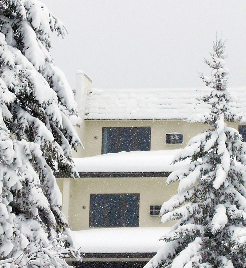
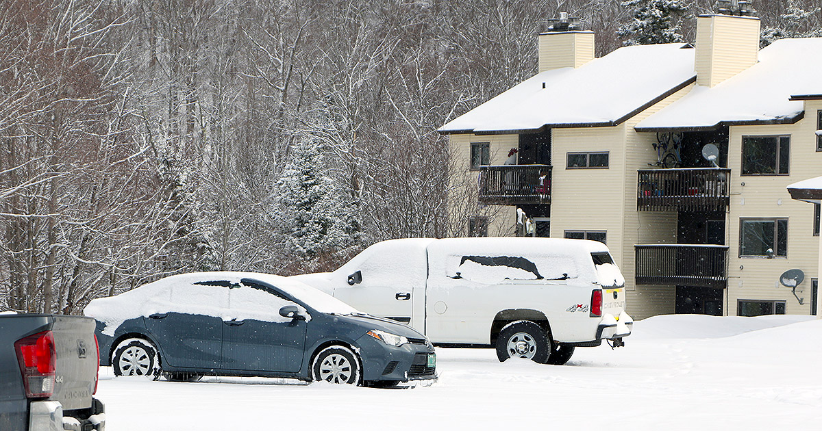
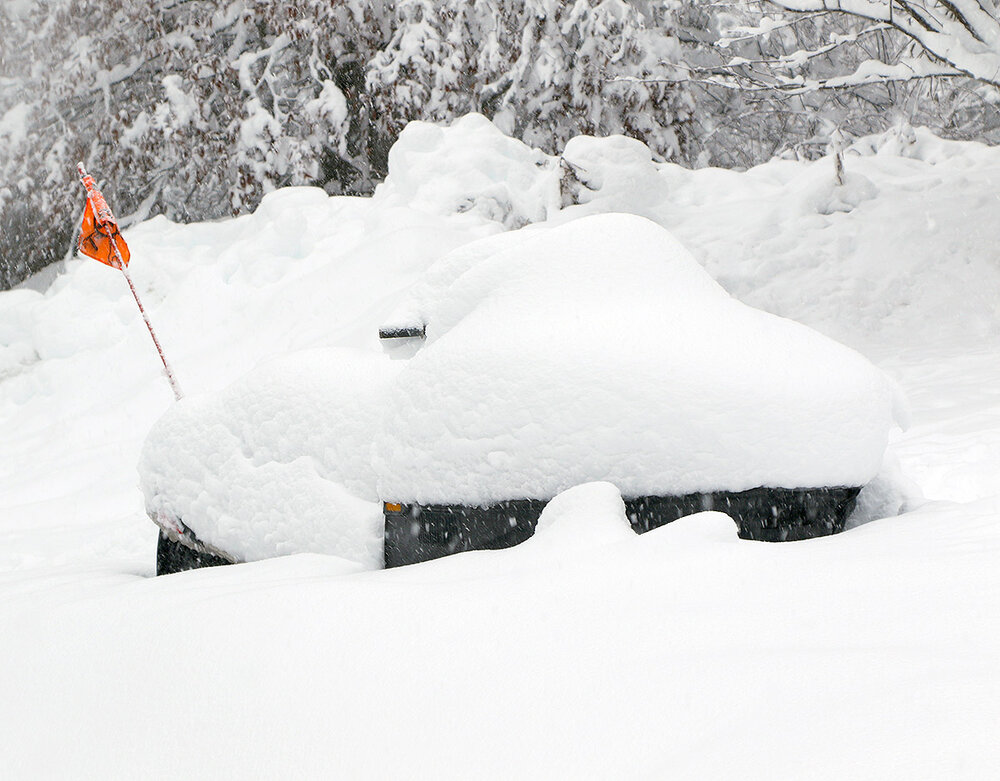
…and then December just continued to deliver.

-
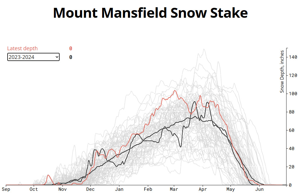
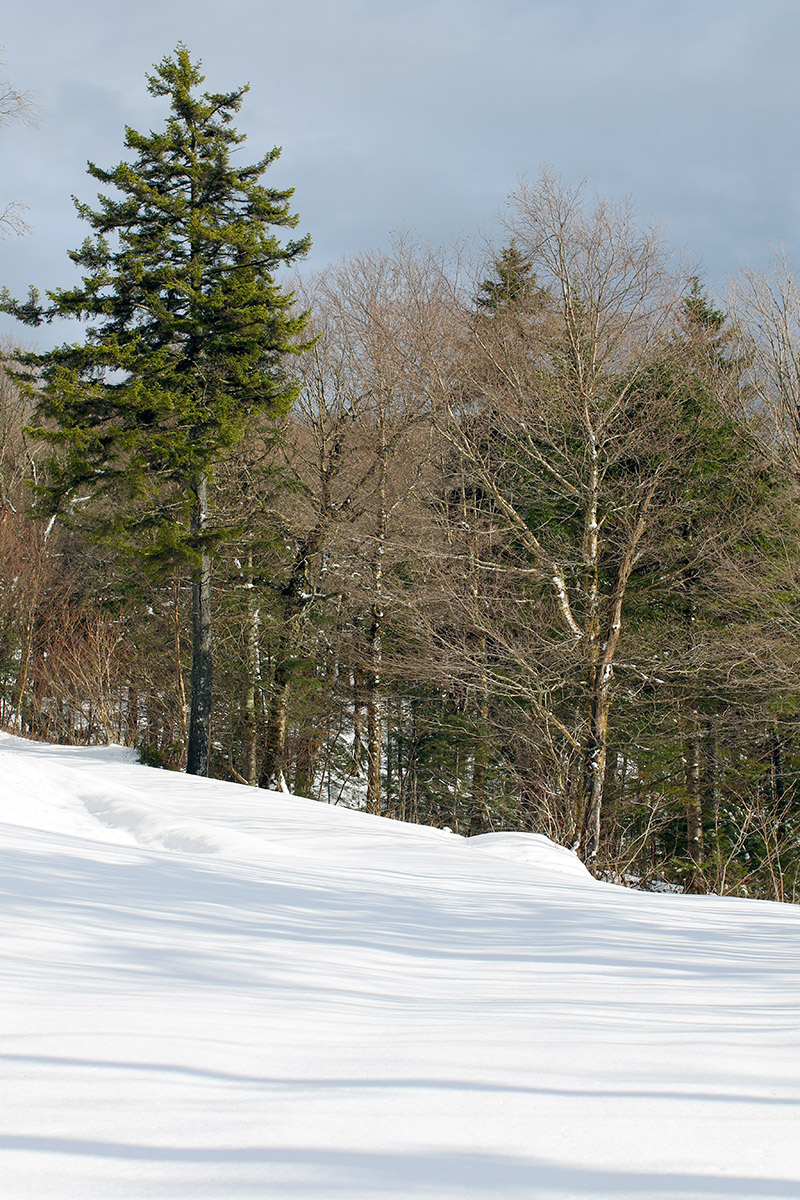
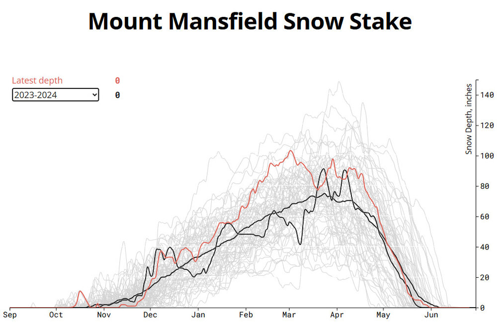
The winter/ski seasons all blur together for me, which I think is in part due to our climate here in the Northern Greens. While we certainly get memorable storms, the majority of the winter features day after day with light to moderate snowfall events, which don’t stand out as easily from one season to the next. In any case, it’s a good climate to maintain high-quality snow surfaces for skiing and riding, and it’s one of the reasons that I really like having the reports from my ski outings to refresh my memory for specific periods though. I was curious about that strong start you mentioned for the 2023-2024 season, and indeed it does pop up on the plot for the Mt. Mansfield Stake data – the snowpack depth hitting 40 inches in the first half of December is a great place to be, and it quickly gets a lot of off-piste terrain in play. I checked my snowfall numbers and saw that our site in the valley only picked up about a foot of snow in the first half of December, which is below average and certainly not a standout performance. After looking a little closer, I realized that November 2023 also brought us 20 inches of snow in the valley, and that was a big help in priming that great start to December. I hadn’t caught that the first big rise in the 2023-2024 snowpack plot is actually from the end of November, but I see in my data that we had 6 snowstorms in the valley in the last 10 days of the month. On my Bolton outing on the 28th I measured the snowpack depth at 20” at 3,000’ and then on the 29th it was up to 24”. The skiing was great even before the calendar hit December.
-
The data I’ve seen indicate that snowfall was decent at most low and high elevation sites around here for the 2023-2024 season, and it looks like it was just the valley snowpack that was on the lean side. The 2023-2024 mountain snowpack appears to be fine based on the Mt. Mansfield Snow Stake data. The black lines on the plot below are for the average snowpack depths and the 2023-2024 snowpack depths, and the red line is for the data from the current season. The 2023-2024 data certainly has its ups and downs, but it comes out pretty close to the average overall. At least for the Northern Greens, it wasn’t really the snowmaking that made it a decent ski season (snowmaking only covers a tiny fraction of a resort’s total terrain anyway, so it can’t really turn an awful season into a good one). In this case it seems that there was sufficient natural snowfall and snow preservation to make for a decent mountain snowpack, which goes along with that additional elevation temperature buffer that PF mentions.
-
I don’t really track temperatures, but in most snow related parameters, the 2023-2024 season was decent at our site. We sit at ~500’ elevation along the spine of the Northern Greens near the bottom of the Winooski Valley. We’re directly between the BTV and MPV sites, just about halfway in fact (~18 miles from BTV and ~16 miles from MPV). -Season snowfall for 2023-2024 was 156.7”, which is close to average, and that total was higher than either of the two previous seasons (2022-2023 snowfall was 150.1” and 2021-2022 snowfall was 134.4”). -The duration of the continuous snowpack season was fairly typical: Nov 19th was the start of the continuous winter snowpack, and that was on the earlier side vs. a mean snowpack start date of Dec 1st ± 14 days. Apr 11th was the end of the continuous winter snowpack, which is just a couple days ahead the average of Apr 13th ± 10 days. -As mreaves noted, the depth of the winter snowpack was on the low side, however. The maximum snow depth at our site for that season was 16.0” vs. a mean of 26.4”, and the 768 snow depth days was about half of average. So at least in the lower valleys in our area, the winter snowpack was present for a typical duration, but its depth didn’t seem to be as robust as usual. If the results above really came from a +7-8 F December through February period, that potentially bodes well in a warming climate though. If the lowest valleys can pull off a decent season in that situation, then the mountains should have no problem doing that with even greater temperature anomalies. Jay Peak reported 369” of snowfall for the 2023-2024 season, so it was similar to our site with respect to running about average.
-
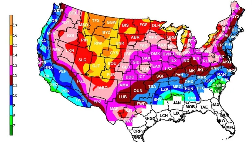
That’s always an interesting comparison, and a big factor in the difference is the very disparate snowfall climatology between the two areas. The two prominent components that go into that SDD/snowfall ratio are the density of the snowfall and the snowpack preservation. Snow preservation here at our site doesn’t appear to be an outlier in either direction locally; between the west side climates and the east side climates along the spine of the Northern Greens, our site’s snow preservation seems to be relatively average. But the east side climate areas, and moving beyond Vermont, areas just east of the Appalachians in general, hold onto cold air the longest and that can help to maximize snow preservation. At our site I’d say it’s the snowfall that has the biggest impact on the SDD/snowfall ratio. And it’s not as if there’s some sort of outrageously high average snow ratio here at our site; it seems right in line with what studies report for the area (see the map and further discussion below). It looks like the high snowfall/SDD ratio here at our site arises from a combination of the area having reasonably strong average snowfall ratios to begin with, and those ratios being elevated even more in seasons with decent amounts of LES/upslope snow. The Northeastern U.S. does represent one of the more dramatic gradients in average snowfall density as one can see from the map. With 6 to 7 snowfall density zones across the region from west to east, the gradient around here is almost as extreme as it is along the west coast of the U.S. There are various studies and maps out there that compare average snowfall ratios across the country, but Weather.com has a nice discussion bringing in data from the 2005 study by Marty Baxter of Central Michigan University, and that’s where I grabbed the map posted above. The mapping of the results from that study shows how the bulk of the BTV NWS forecast area is in that mauve pink shading, which is the 13-14 to 1 range for snowfall ratios. For the period of record in my data set, the mean snowfall ratio is 13.7 ± 1.8, and the median is 13.3, so those data represent what appears to be a strong, normal distribution that is exactly in line with the snowfall ratio range determined in that study. This is the first time I’ve checked on the ratio numbers in a while, but that comparison does give me strong confidence in the methodologies I’m using for both snowfall and liquid equivalent measurements here at our site. The snow to liquid ratio for this past season was 16.6 to 1 (i.e., the water content was 6.0% H2O), which is higher than the average, but quite consistent with this season feeling like we had a decent amount of upslope snow relative to some seasons. If you look at the map, that’s a solid Montana/Northern Rockies style winter right there, with snowfall ratios corresponding to that large area of orange shading. The highest snowfall ratio we’ve recorded here at our site across an entire season is 17.25 (5.8% H2O) in 2020-2021, and the full data set for seasonal snowfall ratios is listed below. Season: Snowfall Ratio ’10-’11: 14.54 ’11-’12: 14.20 ’12-’13: 16.41 ’13-’14: 13.44 ’14-’15: 13.26 ’15-’16: 11.53 ’16-’17: 13.26 ’17-’18: 13.08 ’18-’19: 11.45 ’19-’20: 13.05 ’20-’21: 17.25 ’21-’22: 13.60 ’22-’23: 11.92 ’23-’24: 12.28 ’24-’25: 16.58 Mean: 13.7 ± 1.8 For mountain areas with continental or intermountain snow climates that see minimal melting or winter rainstorms, I often think of the 3 to 1 snowfall to snowpack ratio that I’ve seen PF use for Mansfield (i.e., 300 inches of snowfall produces a snowpack depth of ~100 inches). I’d think a maritime snow climate would be more like 2 to 1, but I’m sure it can vary a lot. This past season, PF recorded 362” of snowfall at his Mt. Mansfield snow plot and the snowpack reached a depth of 103”, so that’s a ratio of 3.5 to 1, which is certainly in that 3 to 1 range. In winter seasons around here without heavy rainstorms, the snowfall climate seems quite intermountain/transitional, but the average snowfall ratio I recorded here at our site this past season would certainly be pushing well into a continental climate. These snow climate classifications are really dialed into the ranges of the western U.S., so there’s not going to be an exact fit for the specific climate of the Northern Greens, but they’re helpful for discussion. We get more rain and temperatures fluctuations here than in the highest elevations of the western U.S., but many of the mid to lower elevation mountain areas out there can get rain and temperature fluctuations above freezing as well, so that’s still part of the climate. These different ratios of snowfall to liquid equivalent, SDD to snowfall, snowfall to snowpack depth, etc. don’t all correlate to each other exactly of course, but they’re still informative. Below was an interesting Reddit discussion I found about the snowfall to base depth correlation – I think some of the people’s numbers are way off from reality, but it sounds like some of them are from personal experience, so that’s potentially useful: https://www.reddit.com/r/skiing/comments/1hi5rr8/how_does_snowfall_translate_into_increase_in_base/ https://avalanche.org/avalanche-encyclopedia/weather/snow-climate/
-
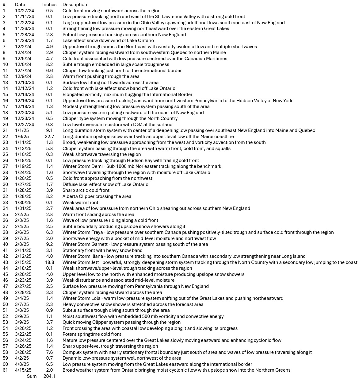
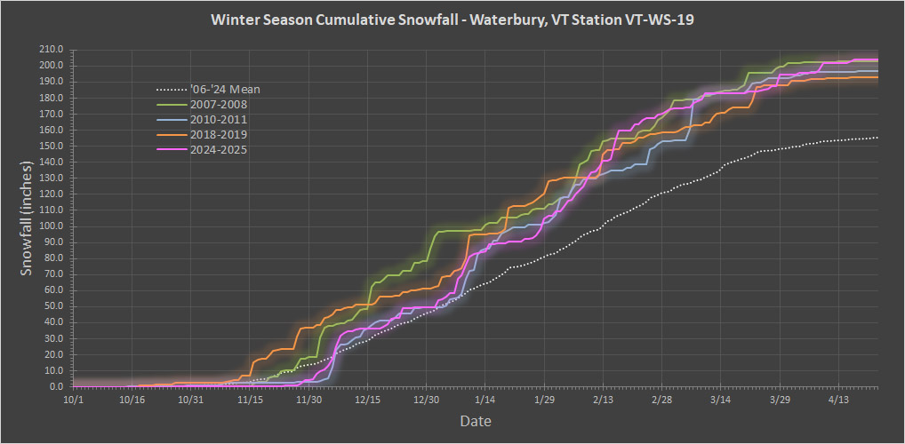
Following up on the 2024-2025 winter summary, I’ve put together the season’s storm list for our site. The number of storms was above average, but below the 64 storms we had in the 2018-2019 season.

-
We’re into June and the snow season should be complete here in the valley, so I’ve put together the summary snow data for the 2024-2025 winter season at our site. It was another solid season, right up there with 2007-2008, 2010-2011, and 2018-2019 in terms of snowfall as the plot below shows. These types of seasons are in that top 20% of the data set for snowfall, so something that happens roughly every 5 years on average. The three big midwinter months of December, January, and February were above average on snowfall, but the rest of the months were below average or close to average at best. That meant the season didn’t really break away from the rest of the pack, but if you’re going to have only three months be above average on snowfall, those midwinter months are the ones to do it and still get a solid season. It wasn’t a season for huge storms with only two storms over 18 inches, but it felt like a decent season for upslope snow. Total Snowfall: 204.1” October Snowfall: 0.5” November Snowfall: 4.0” December Snowfall: 45.1” January Snowfall: 59.5” February Snowfall: 62.1” March Snowfall: 23.6” April Snowfall: 9.3” May Snowfall: 0.0” Total Days with Snowfall: 116 October Days with Snowfall: 2 November Days with Snowfall: 7 December Days with Snowfall: 25 January Days with Snowfall: 28 February Days with Snowfall: 25 March Days with Snowfall: 19 April Days with Snowfall: 10 May Days with Snowfall: 0 Snowstorms: 61 October Storms: 1 November Storms: 5 December Storms: 14 January Storms: 14 February Storms: 14 March Storms: 10 April Storms: 3 May Storms: 0 Average Snowfall per Storm: 3.3” Largest Storm: 22.7” 2nd Largest Storm: 18.8” 3rd Largest Storm: 9.3” 4th Largest Storm: 9.1” 5th Largest Storm: 8.2” Sum of 5 Largest Storms: 68.1” Storms ≥10": 2 Date of Largest Storm: 1/6/25 Earliest Frozen Precipitation: 10/16/24 Earliest Accumulating Snowfall: 10/27/24 Earliest 1" Storm: 11/28/24 Earliest 2" Storm: 11/29/24 Earliest 3" Storm: 12/2/24 Earliest 4" Storm: 12/3/24 Earliest 6" Storm: 12/7/24 Earliest 8" Storm: 12/7/24 Earliest 10" Storm: 1/8/25 Earliest 12" Storm: 1/9/25 Latest Accumulating Snowfall: 4/17/25 Latest Frozen Precipitation: 4/17/25 Length of Snowfall Season: 173 days Start of Season Snowpack: 11/28/24 October days with Snowpack: 0 November days with Snowpack: 3 December days with Snowpack: 31 January days with Snowpack: 31 February days with Snowpack: 28 March days with Snowpack: 31 April days with Snowpack: 15 May days with Snowpack: 0 Days with >0" Snowpack: 139 Days with >0.5" Snowpack: 122 Days with ≥1" Snowpack: 116 Days with ≥2" Snowpack: 107 Days with ≥3" Snowpack: 103 Days with ≥4" Snowpack: 99 Days with ≥6" Snowpack: 82 Days with ≥8" Snowpack: 66 Days with ≥10" Snowpack: 54 Days with ≥12" Snowpack: 48 Days with ≥24" Snowpack: 11 Days with ≥36" Snowpack: 0 Max Snow Depth: 34.0” Date of Max Snow Depth: 2/17/25 End of Season Snowpack: 4/13/25 Continuous Snowpack Season: 137 days Snow-Depth Days: 1346.0 inch-days Total liquid equivalent: 22.51” Frozen liquid equivalent: 12.31” % Frozen L.E.: 54.7% Total Snow/Total Liquid Ratio: 9.07 Total Water Content: 11.0% Total Snow/Frozen Liquid Ratio: 16.58 Frozen Water Content: 6.0%

-
It has happened, but only naturally in Tuckerman Ravine. I’ve never heard of it happening at a ski area with manmade snow (although I’m sure they could pull it off it they wanted to by simply making enough snow and using blanketing techniques, etc.) It looks like the last time it happened was 1926, and that appeared to be unusual, but it may have happened more in the preceding century. Regarding the snow in Tuckerman Ravine from the link below: “It lasts longer here than in any other area in the eastern United States. During recent years it has disappeared, on the average, during the first week in August, but it persisted through the summer of 1926, “for the first time in the memory of the old timers” and new snow fell on the old in October.” I think it’s much more about the spring/summer temperature, humidity and precipitation regime and how soon temperatures cool down in the autumn vs. total snowfall for the previous season. And for Tuckerman Ravine, I bet the season’s avalanche patterns would have an effect as well. https://www.cambridge.org/core/journals/journal-of-glaciology/article/an-historical-survey-of-the-lateseason-snowbed-in-tuckerman-ravine-mount-washington-usa/9A5964D0AA6C9D6E9D5A2C55493F4F1C
-
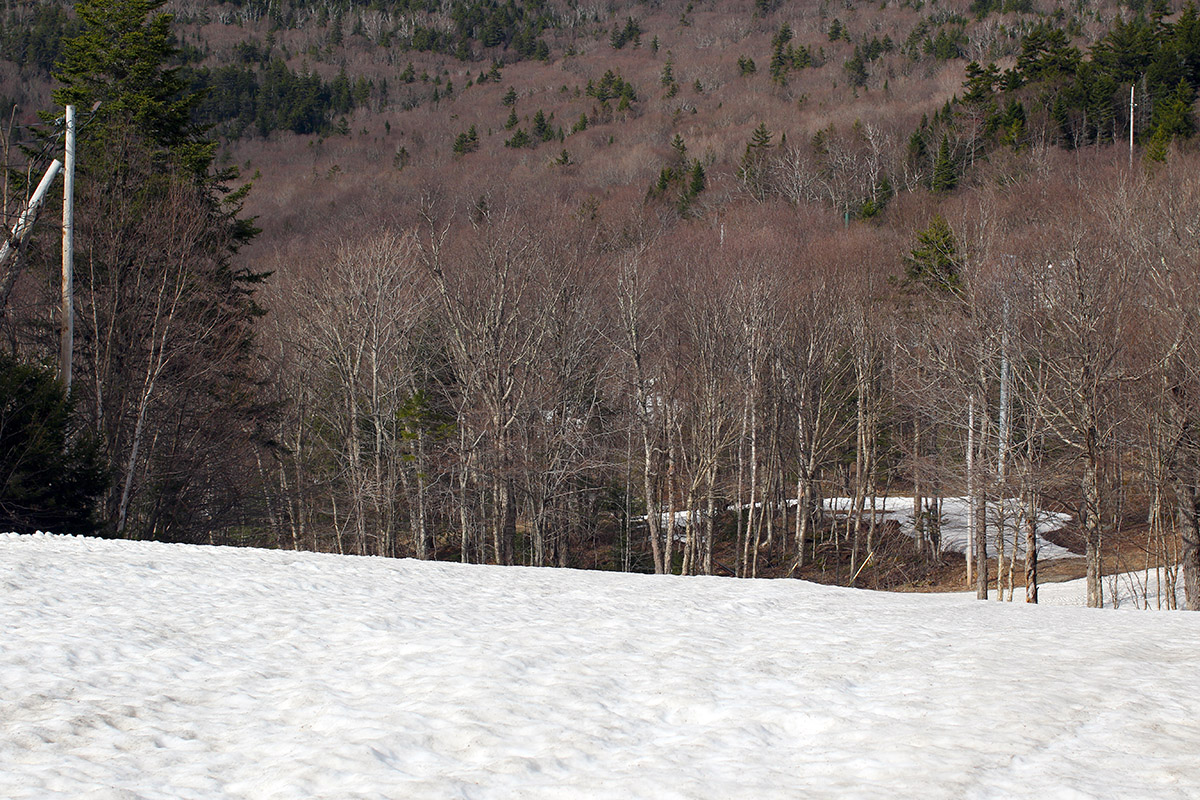
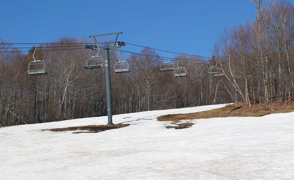
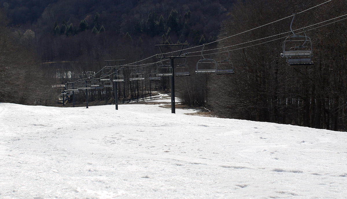
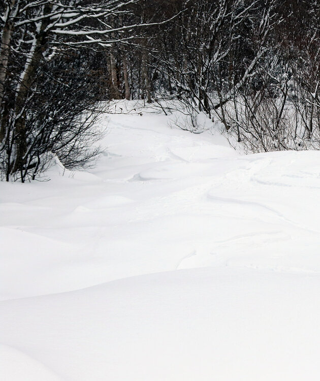
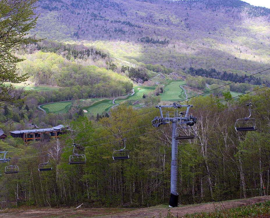
The weather was so nice yesterday that I thought about hitting the trails for a bike ride, but then I realized there was still snow and a ski tour was probably the way to go. There will be plenty of riding in the coming months, but ski options are winding down. I headed to Stowe and figured that I’d likely have to ski on the Mansfield side because the south-facing Spruce Peak terrain was melted out, and indeed that was the case. There were only a few patches of snow visible from afar when I looked at Spruce Peak. I’d expected to ski in the Nosedive area, since its orientation and protection from the sun make it a common late-season holdout, but I was surprised that I didn’t see much snow there. I’m sure it still has some snow, but not being able to see obvious areas of good coverage had me looking elsewhere. Liftline had a section of snow in the low to mid-elevations for fairly easy access, but the terrain over by the Sunrise Six seemed to offer the most lower elevation options by far. There were definitely plenty of sun cups and groomer ruts in sections of the snow, but temperatures were warm enough to keep the snow soft enough for some decent turns
-
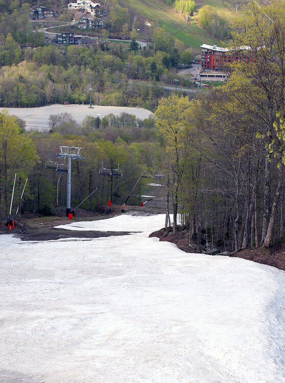
The forecast for the coming days looks fairly unsettled and showery, so I decided to take advantage of the sunny conditions yesterday to get out for a ski tour up at Bolton Valley. I expected that I’d need to head up to the main base at 2,000’ because the Timberline area would be too melted out to offer decent touring opportunities, and indeed that was the case. On the way up the Bolton Valley Access Road, I could see that the Timberline terrain was down to just patchy snow. There are still some continuous routes of snow up at the main mountain though, so that worked out well to get in some afternoon touring. Enough areas of terrain above the main base have melted out to make it practical to go with either hiking or skinning on the ascent. I just had my skis on my pack to simplify things without the need to bring skins, and indeed I found plenty of grassy areas for hiking. The snowpack at Bolton is certainly developing sun cups/melt cups in many areas now, so the turns weren’t as smooth as my past couple of outings, but with the warmth and sun, the snow was definitely soft enough for some decent spring turns.

-
Several days back, it looked like today held the potential to be one of those warm, sunny ski days with spring corn snow. Mother Nature appeared to have other plans though, and the weather modeling quickly started to show the potential for fresh snow instead of sunshine. Indeed, the snow came to fruition, and as of this afternoon, snow levels had dropped all the way to the bottoms of the valleys. Down at our site in the Winooski Valley, it snowed much of the afternoon, with decent intensity at times, but temperatures were a bit too warm to see any substantial accumulations. Accumulation was easy at higher elevations however, and after a quick look at the thick white coating visible on Bolton Valley Main Base Webcam, I popped up to the mountain for a ski tour. Heading up the Bolton Valley Access Road, snow accumulations began to appear around the 1,200’ elevation. I found 2 to 3 inches of new snow in the Village at ~2,000’ where I started my tour, and my ascent revealed that the 2,000’-2,500’ elevation band saw the most rapid accumulation gains. I found 5 to 6 inches of new snow at 2,500’, with only modest gains above that up to ~3,200’. The elevation profile for accumulations in the Bolton Valley area today were as follows: 340’: 0” 500’: 0” 1,000’: 0” 1,200’: T 1,500’: T-1” 2,000’: 2-3” 2,500’: 5-6” 3,000’: 6-7” 3,200’: 6-8” By the time I was out for my tour in the late afternoon, temperatures were above freezing at all elevations of the resort, so the new snow was already wet. And it definitely skied like wet snow at that point, but there was plenty of liquid in there to keep you off the old base at most elevations above 2,000’. In any event, it’s always great to get out for a tour in fresh snow, and the sun had quickly come out as the storm pulled away to make for some excellent views. The weather modeling suggests we may get another shot at snow in about a week or so, so we’ll keep an eye on the potential for more touring in fresh accumulations as we head into May.


-
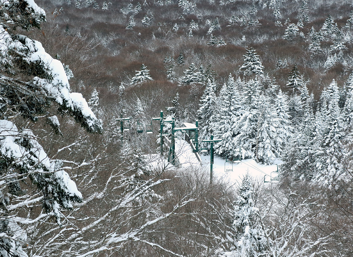
Yesterday was relatively warm with temperatures in the 60s F, but it was cloudy with on and off showers and even some rubles of thunder. Today the temperatures cooled back down into the 40s F, but with clear skies that was easily warm enough to set up for some excellent corn snow and step up as the better ski day of the weekend. I was thinking of heading to Stowe for some ski touring this afternoon, but by the time the family was done with the day’s Easter activities it seemed more practical to pop up to Bolton Valley instead. I was hoping that the Timberline area would still have enough snow for touring, and indeed it does, with fairly deep snow on the Showtime trail all the way down to the Timberline Base at 1,500’. I toured up to roughly 2,200’ to the Showtime Headwall below the Timberline Mid Station, and immediately above that point the snow had been scoured and melted out. There were only a couple of tracks around from previous skiers, and we’re nowhere near the point of dealing with sun cup issues yet, so the snow surface was a beautiful sea of perfect peel-away corn. With temperatures in the 40s F, there were no issues with stickiness, so it skied really well. The only weather issue of note was that there was a stiff westerly breeze at times, but the combination of air temperatures, sunshine, and the breeze came together to produce some fantastic snow surfaces. Based on the numbers from the Mt. Mansfield Stake, there’s still 6 to 7 feet of natural snowpack in the higher elevations of the Northern Greens, so that snowpack should be there for quite a while. The spring thus far has been fairly cool and snowy, so it really feels like the corn snow spring skiing season is just getting started. Barring any abnormal warmth, there should be several weeks to go and hopefully many chances to hit the slopes at Stowe as well.


-
Well, whether it ends up being ± whatever actual amount of liquid equivalent in the end, I find that on average, the GFS is the best of the tools in that medium range timeframe for northern stream and upslope systems in the Northern Greens. The ECMWF model is quite good in general of course, but it and the other medium range models just don’t seem to “see” the mountains around here in the same way with whatever physics they implement. In any event, the BTV NWS is already paying attention to the potential from Tuesday through the end of the week. It is fitting though to see a quote from the experts that says: “…and with a tendency for these events to last on the longer side of guidance, trended toward this solution.” As someone who lives along the spine of the Northern Greens and routinely documents the snowfall from these events, that seems to be an aspect that the GFS typically “gets” more than some of the other equivalent models. It’s also interesting to hear about the difficulty in using ensemble data as effectively for these types of events because it’s too coarse to resolve the terrain well. LONG TERM /TUESDAY NIGHT THROUGH SATURDAY/... As of 339 AM EDT Sunday...Upslope precipitation begins Tuesday night and will continue through Wednesday. The mountains should see exclusively snow, and with steep lapse rates, much of it should be powdery. As temperatures rise during the day Wednesday, there could be a little rain mixing in in the valleys, but the steep lapse rates could cause it to be all snow despite temperatures well above above freezing. The precipitation will be snow everywhere Wednesday night. There is some uncertainty on when the upslope precipitation ends. Some guidance keeps it going all the way through Thursday, and with a tendency for these events to last on the longer side of guidance, trended toward this solution. However, snow would likely be lighter and more scattered on Thursday as the depth of the atmospheric moisture declines. Ensemble probabilities are tough to use in these upslope cases since they are too coarse to resolve the terrain well, so looking at the deterministic guidance, several inches look likely in the northern Greens and Adirondacks, with the possibility for significantly more. It looks like the upslope precipitation should taper off by Friday at the latest, and ridging will briefly build into the region to end the week.
-
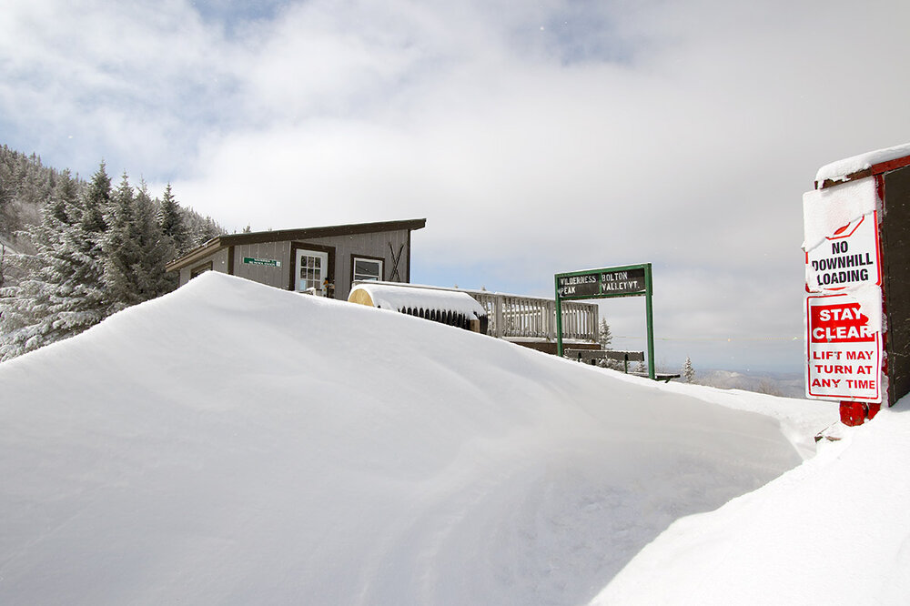
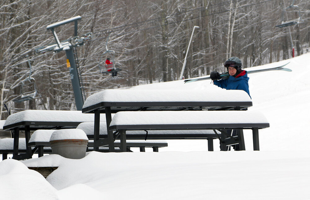
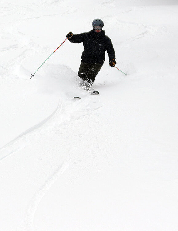
It’s April in the Northern Greens, and our most recent storm came through the area yesterday, finishing up overnight with 4-8” of snow in the valleys and 12”+ for the local ski resorts. Bolton Valley was reporting 13” of new snow from the system in their early report, so I hit the mountain this morning for some touring in the fresh powder on my way to Burlington. The ongoing April temperatures, rounds of new snow, and the upcoming forecast have been decent enough that Bolton has decided to add some extra innings to their operations schedule this week, but they weren’t starting up the lifts today until noontime. That meant that the resort was on the quiet side this morning; only about ¼ of the upper Village lot had some cars from folks out ski touring and taking care of other things at the resort. My car’s thermometer was reporting temperatures in the mid-teens F when I started my morning tour, but even if you weren’t in direct sun, you could tell it was April – the solar radiation is just that strong at this time of year. The weather overall on the mountain today was a gorgeous April mix of light to moderate snow at times, scattered clouds, and frequent breaks of direct sun. The system that brought the snow was pulling away and there wasn’t really any wind behind it, so it was warm enough to be comfortable but still well below the point where temperatures would have affected the quality of the powder. And indeed, although this was an April storm system, the powder it delivered was midwinter dry. Down in the lower valleys, the snow did start out on the denser side for the very beginning of the system; my liquid analyses indicated 8-12% H2O snow during the day yesterday, but the bulk of the snow fell overnight, and that snow density was in the 3-5% H2O range. While the wind had dissipated by this morning, there was definitely some wind with the system, because the effects of the drifting on the dry snow was evident. As long as you avoided scoured areas though, bottomless powder turns were readily available. When I saw the storm total exceeding a foot up at the resort, I decided it was another day for the fat skis, and they were indeed an appropriate tool for the job. There was quite a snowfall gradient with this storm as one headed up from the valley, and there was a real solid jump in accumulations between 1,500’ and 2,000’ that made touring out of Bolton’s main base area the clear choice. Here’s the accumulations profile I found from this morning’s outing: 340’: 1” 1,000’:1-2” 1,500’: 3-4” 2,000’: 7-9” 2,500’: 8-12” 3,000’: 12”+ I went on the conservative side with accumulations in those upper elevations, but there were plenty of areas with a good 12-13” at 2,500’ and 15-17” at 3,000’ that weren’t drifts. I just couldn’t find those depths consistently enough to call them representative overall for those elevations. In this morning’s report, Bolton Valley was at 374” on their season snowfall total, and as we approach mid-April, the ski resorts in the Northern Greens are generally reporting season snowfall the ±400” range. That’s above average, and it looks like another April system may be hitting the area this weekend with more potential snow for the mountains, and there could be additional snow next week as well.
-
It looks like that was a decent call – I’m seeing a lot of 4-8” totals for the valleys and 12”+ for the elevations.
-
Based on the weather, yesterday really wasn’t a day that I would have typically hit the mountain for skiing. It was one of those spring “in between” days, where temperatures weren’t cold enough that we were getting fresh snow, nor was it warm and sunny enough that we were really getting a nice spring skiing day. But my younger son and a number of his friends were heading out to partake in Bolton Valley’s pond skimming portion of their big “Spring Thing” event, so we decided to head up to check that out and get in some skiing. From what the website indicated, this was the first time they’ve put on a pond skimming event in about a decade, and they were also trying out dual slalom mountain bike races on snow - which seems like a pretty unique event. I typically shy away from skiing on these middling spring days because you can end up with hard snow surfaces without either enough fresh snow to cover them up, or enough warmth to soften them up. Surprisingly though, the snow yesterday ended up being fine. Even though the temperatures on the mountain were only around 40 F at the base, and it wasn’t sunny, the surfaces had softened into some nice spring corn snow. Snow surfaces were just a bit firmer up near the ridgeline above 3,000’, but even there they were soft enough to be corn. The weather took a turn as we approached midday and precipitation moved in. It was a combination of sleet and rain, and while it didn’t really affect the snow surfaces, riding the lift and skiing were much less pleasant because of the precipitation falling. We headed out at that point, but from what I saw on the radar, that precipitation eventually pushed through by later in the afternoon when the resort was running the bike races.

-
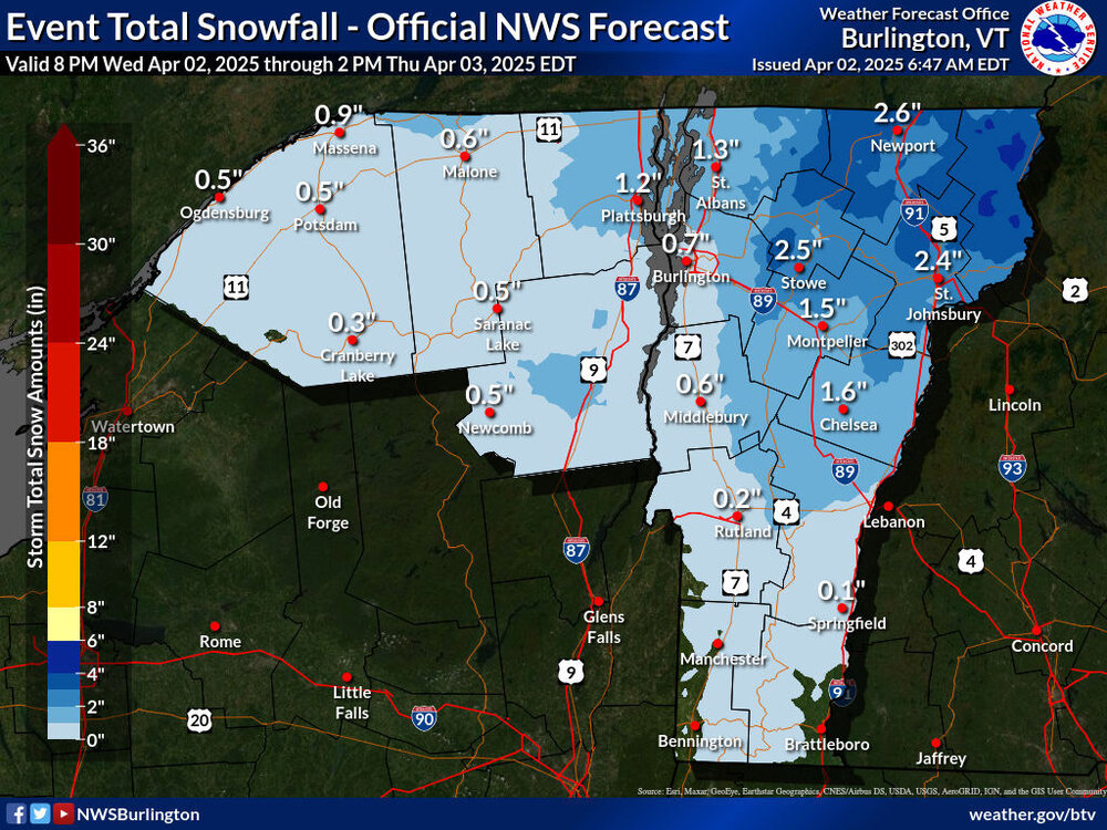
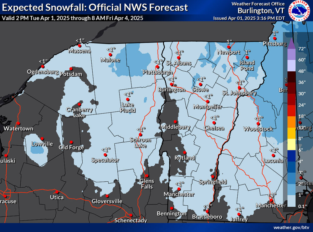
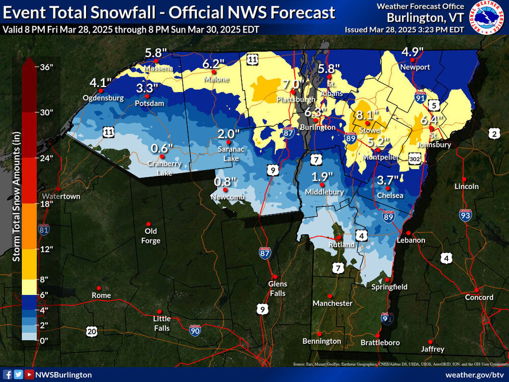
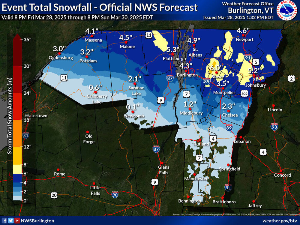
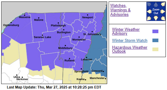
I saw on TWC this morning that the snow in our point forecast had been increased for this next incoming system, so I stopped in at the BTV NWS site to check on their updates. There was a substantial expansion to the coverage area of the Winter Weather Advisories and some increases in projected snowfall amounts on the Event Total Snowfall map.

-
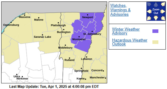
Earlier this afternoon I received an alert that we’d been put under a Winter Weather Advisory for the weather coming into the area tomorrow. I haven’t seen the updated BTV NWS forecast discussion yet, but in the available discussion they mention “a winter wx advisory type of an event is expected from the combination of snow changing to freezing rain/sleet, followed by rain on Thursday midmorning.” The headline link just brings one to the standard winter weather page and the map suggests an inch or two of snow at this point.
-
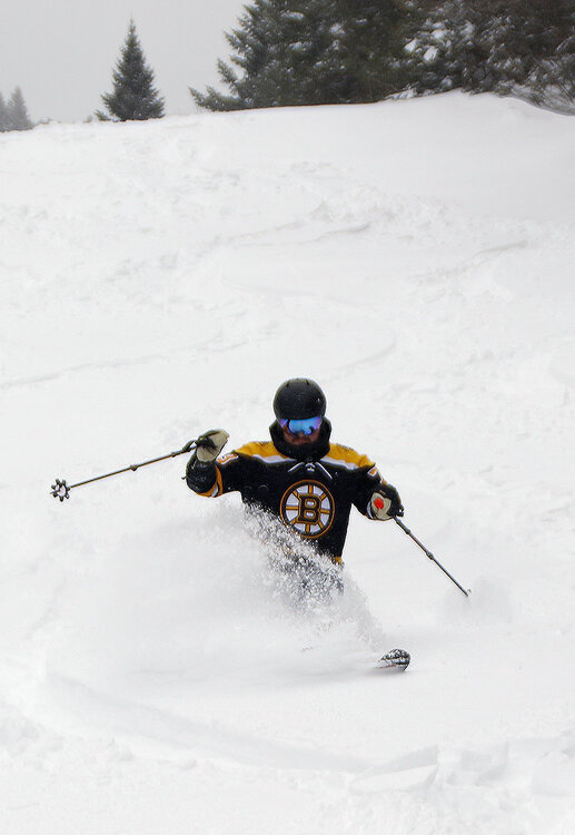
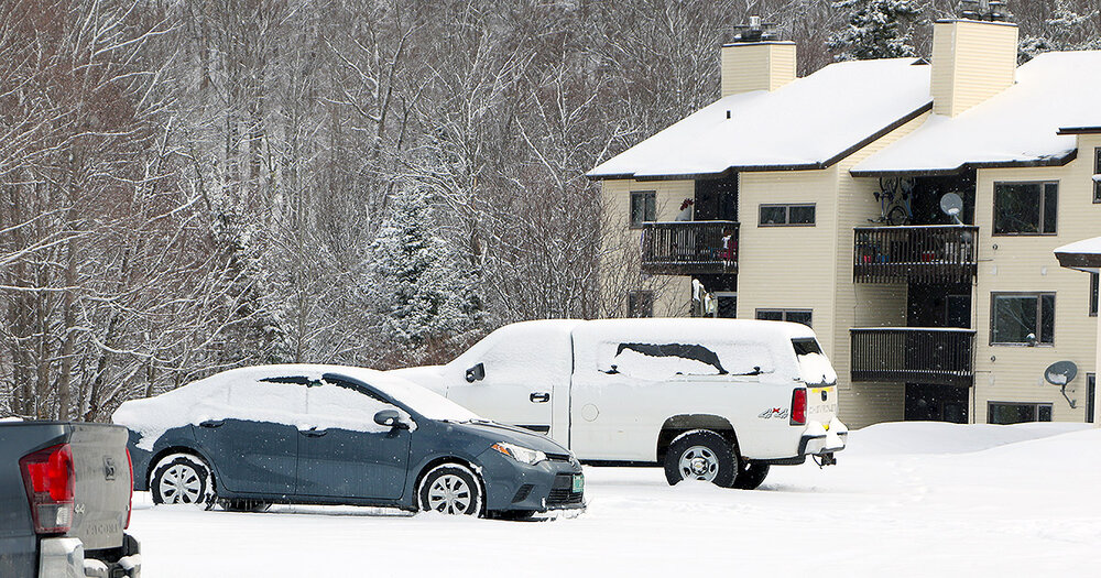
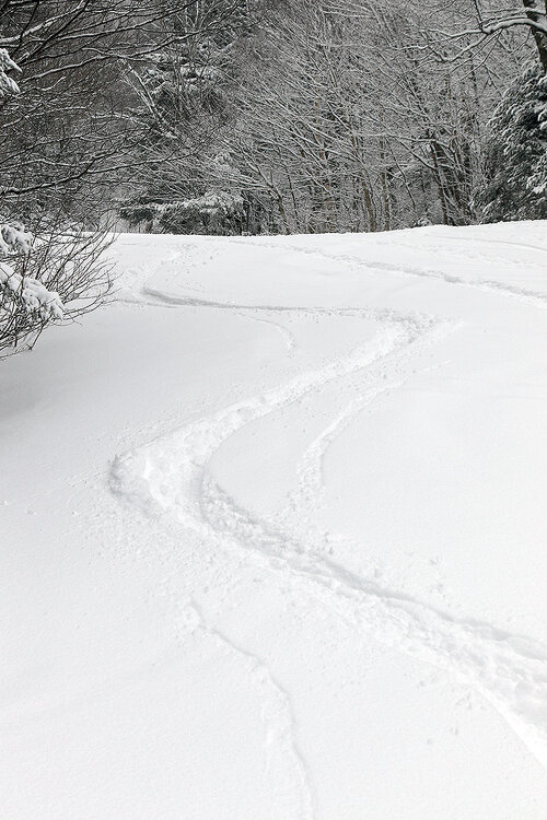
Snow from our latest winter storm began to fall late Friday evening, and then it really hit hard overnight with snowfall rates of an inch per hour or more that lasted into the early morning. Bolton Valley was already reporting 8 inches of overnight snow as of their early 6:30 A.M. report, with more snow still to come. My liquid analyses from down in the valley indicated that we’d picked up ¾ inches of liquid equivalent in the snow at that point, so the mountain probably picked up in the range of an inch of liquid equivalent, and you could feel it in the snow. The snow at our site came in right around 10% H2O, so this storm generally brought medium weight powder. Even on the mountain the new snow fell with minimal wind, so it was a very even coating across the entire resort that set up some excellent skiing both on and off piste. My wife and I headed up to Timberline for the chair’s opening, with plans to quickly meet up with our younger son and several of his friends for a session. While we waited to group up, we took a run on Twice as Nice, which had just a few tracks on it and plenty of untouched powder. As the numbers suggested, there was plenty of liquid in the new snow for a resurfacing on just about all terrain, and even on mid-fat skis, bottomless turns were the rule. Being such a low elevation trail with only natural snow, I believe Twice as Nice had been closed due to some areas of poor coverage after our run of spring warmth. But a testament to the resurfacing ability of this storm was the fact that ski patrol was able to open it right back up for some great skiing. You could still see some of the taller evergreen shrubs sticking out of the snow, but those were pretty easy to avoid. After that first run at Timberline, we teamed up with my son and various friends and spend the rest of the session over at the main mountain. We skied everything from mellow to very steep, and on many occasions, I was surprised by just how well the powder was covering everything up. We knew the subsurface would be fairly hard after days of spring temperature cycling, but time and time again I’d jump into steep tree lines, and whenever you had untouched snow, it kept you entirely off the base. Temperatures were generally in the upper 20s F, but as we got into the afternoon, we could tell that the temperature was creeping up around the freezing mark; the powder was starting to get a bit denser in the lower elevations, and packed areas of snow were taking on hints of that wet pack type of surface. Bolton is reporting 12 inches of total snow in the past 48 hours, so this storm was certainly a nice shot in the arm for the local spring skiing. The snowpack depth at the Mt. Mansfield stake is also back up to just shy of 100 inches thanks to this system and the one we had earlier in the week. So indeed, March has been behaving like March, with some warmth but also continued winter storms to help with the mountain snowpack.


-
I received an afternoon text that we’d be put under a Winter Storm Warning, and in the BTV NWS forecast discussion they mention that they put it up for areas with an 80% chance of seeing at least 7 inches of snowfall through the event. Those are also areas in which very heavy snowfall rates of 1 to 2 inches per hour are expected tomorrow morning. In line with this update, there’s also a more expanded area of 8-12” snowfall shading in this part of the Northern Greens.

-
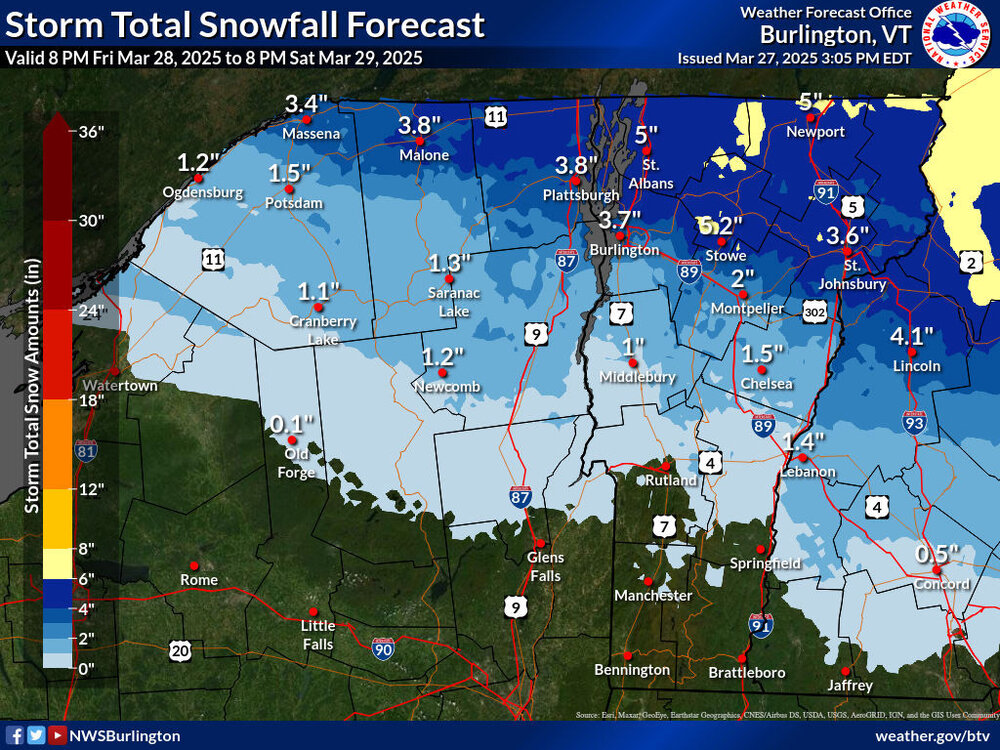
There hasn’t been much change to the BTV NWS advisories map, but the Event Total Snowfall map has seen some adjustments with their latest update. There’s an expansion of the areas with 6-8” shading in Northern Vermont, and now some 8-12” coloring is appearing along the eastern slopes in the Stowe/Smugg’s area. In general, the snow accumulation zones were extended a bit farther south, presumably based on changes seen in more recent modeling runs. In our area, the point forecast for snow has been bumped to roughly the 4-8” range, which seems consistent with the updated map. The BTV NWS forecast discussion clearly notes how difficult it is to pin down specific snowfall amounts with how tight the gradient is along the front, so they’ll just have to keep watching the guidance and we’ll get their latest thoughts in the next update.
-
This afternoon I received an alert that we’d been put under a Winter Weather Advisory for the storm expected to affect the area tomorrow night into the weekend. The BTV NWS forecast discussion indicates that the highest totals look to be across parts of Northern Vermont, where 3 to 7 inches and locally higher totals are expected, but the frontal boundary is sharp, and snow totals are highly dependent on where that front sets up. In any event, the Storm Total Snowfall Forecast Map has areas of 4-6” and 6-8” shading around the Northern Greens, which seems to line up fairly well with the discussion. At our site in the Winooski Valley, our NWS point forecast suggests snow accumulations in the 2-4” or 3-5” range. Most of the weather modeling suggests total liquid equivalent from the system in the range of 1 to 2 inches, so it could represent a solid resurfacing for the slopes where the precipitation stays mostly snow, or even sleet. The latest BTV NWS maps are below.
-
Similar to both December and January this season, March has had an interesting mid-month lull in snowfall. The first 10 days of the month saw six systems come through the area under what I’d describe as a March-style bread and butter pattern here in the Northern Greens. That stretch produced more than a foot of snow down at our site in the Winooski Valley. Then, the middle 10 days of the month brought some warm spring-like temperatures to set up great corn snow skiing. But like clockwork, as soon as we hit the 20th and got into the last third of the month, Mother Nature decided it was time to get back to winter and it started to snow again. We’ve been gradually working our way back into another bread-and-butter pattern of systems, with 3 storms passing through the area so far, and the potential for another 3 to 4 systems shown in the modeling through the end of the month. With the current pattern, the rounds of snow that have been hitting the area delivered accumulations in relatively modest doses that hadn’t had a chance to resurface the temperature-cycled spring snowpack, but this latest system decided to kick it up a notch. When I saw Powderfreak’s report yesterday evening of 4 to 5 inches of new snow on Mt. Mansfield, it piqued my interest. Later that night when we started to get huge flakes all the way to the valley bottoms bringing moderate to heavy snowfall, I knew it was time to prep the skis for some morning turns. Powderfreak’s report from this morning confirmed that Stowe had indeed received a healthy shot of powder, and as of this afternoon, Mt. Mansfield’s snow total since yesterday morning was over a foot. Bolton Valley seemed a bit slow updating some versions of their snow report this morning, but it looked like they’d picked up 4 to 5 inches of new snow overnight. In our area of the valley, we’d also picked up a couple inches of new snow from this latest system, so those numbers made sense for the elevations. There seemed to be substantial elevation dependence with respect to the snowfall though, and indeed, the lower elevations of the Bolton Valley Access Road didn’t even have a trace of snow as I began the ascent this morning. It wasn’t until I hit about 1,000’ that I saw any of the new snow at all. With that in mind, I cruised right past Timberline and headed up to Bolton’s main base to use the Wilderness Uphill Route for today’s ski tour. Powder depths at 2,000’ were 4 to 5 inches, and 6 to 7 inches where I topped out around 2,700’ The snow seemed fluffy on my ascent, so I was wondering if it the new accumulations were going to be substantial enough to keep me off the spring base, but the snow ended up being way more buoyant than I’d thought it would be. On mid-fat skis, I was able to get roughly 95% bottomless turns on low to moderate-angle terrain, so the powder skiing ended up being great. Getting out in the morning was definitely the play in terms of hitting the powder though, because I could tell that the temperatures were starting to rise above freezing as I was finishing my tour. Here’s the elevation profile for new snow depths above the old base from today’s observations in the Bolton Valley area: 340’: 0” 500’: 0” 1,000’: 0-1” 1,200’: 1” 1,500’: 2” 2,000’: 4-5” 2,500’: 5-6” 2,700’: 6-7” Overall, it’s felt like a busy season at the resort. I’m sure one factor in the number of people coming up to the mountain has been the consistently good conditions we’ve had thanks to the lack of any large, warm systems during the heart of winter. You can tell we’re into March now though, at least with respect to the number of cars that were in the Village parking lots this morning in the first hour or so of lift operations. Even though it was a decent powder day, tiers 1 and 2 of the Village lots were only about half filled. Indeed, it’s a weekday, but that’s definitely far less than what I was seeing on equivalent days just a few weeks back. As noted, the weather modeling suggests there are a number of wintry systems in the pipeline in the near future, and that potential keeps going well into April. But as is typical this time of year, the temperatures may be marginal with some of the events, so elevation will be helpful. With the mid-month warm stretch we had, the snowpack at the Mt. Mansfield stake dropped down a bit from where it peaked at over 100 inches, but it’s at 90 inches today after these recent snows, so there’s a lot of liquid equivalent in there to support plenty of turns in the coming weeks.

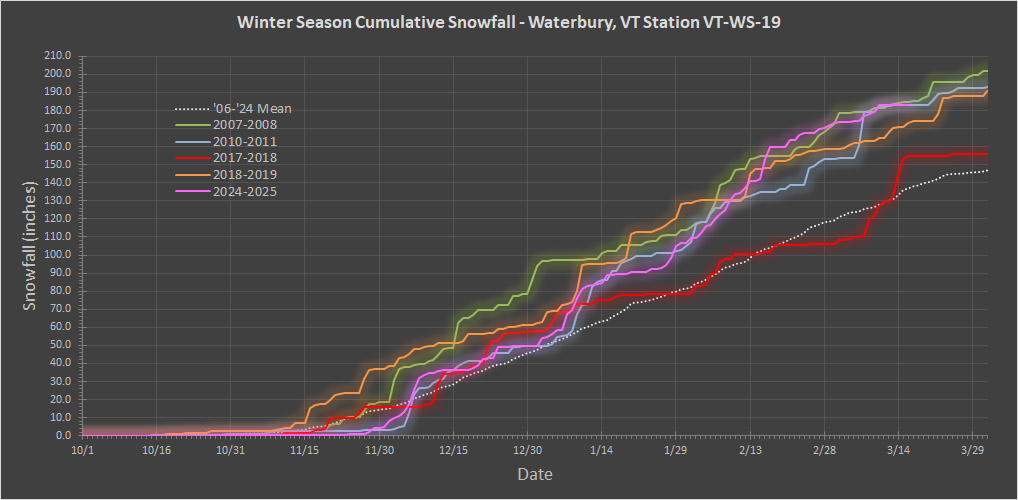
-
Total snowfall for 2017-2018 was 167.2”, so just a bit above average. I added it to the plot as the red trace below, and you can see that at this point in the season it was not up in the cluster of these seasons on the higher end of totals.
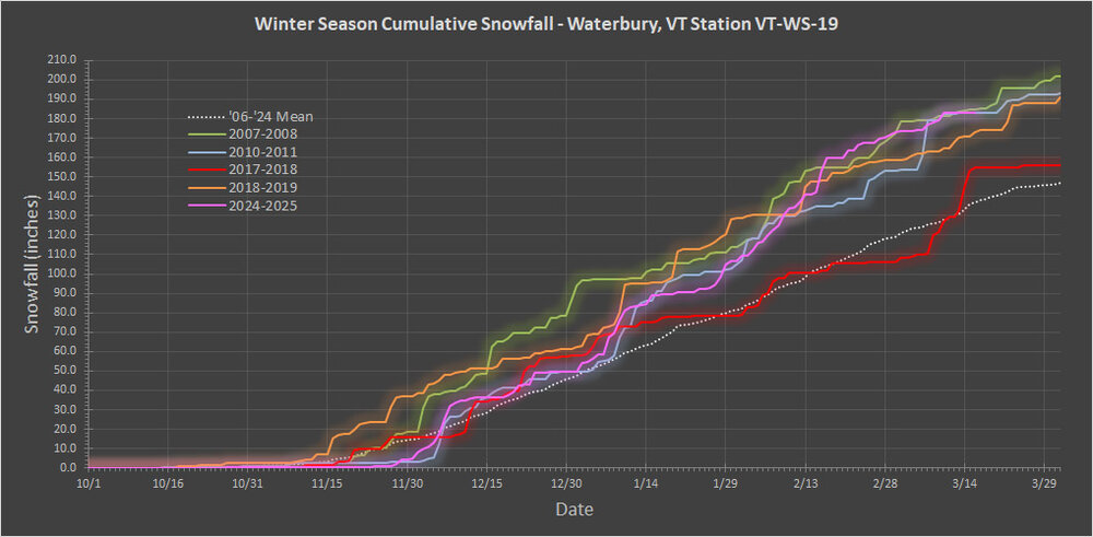
-
Thanks for the update PF. That lavender blue coloring demarcation for 120”+ really makes the Northern Greens stand out and reveals how snowy some of the lower elevation sites are around here. Since snowfall routinely starts up in October/November in our area, I don’t generally think about the “meteorological winter” block of time in isolation, but your post prompted me to check my data. It looks like this season actually had the highest snowfall for that period on my records. As I mentioned earlier, December, January, and February all ran above average on snowfall, and that doesn’t happen too often. The current season isn’t in first place on overall snowfall at the moment because of the relatively slow November for the lower elevations, but if we’d had even a roughly average November, we’d be around 200” of snowfall already and it would certainly be in the lead. It’s just not easy to pull off month after month after month after month of above average snowfall, which is of course why the overall averages are what they are. In any event, it’s mid-month and a good time to check in on the season’s snowfall progression, so the updated plot has been added below. For some reason, people hadn’t mentioned the 2010-2011 winter season in the discussion yet (I guess it was a little behind the others back in February), but it’s clearly in the same range as these other seasons that are part of the conversation, so I’ve added it to the snowfall progression plot as a light blue trace. As far as this season’s snowfall progress is concerned, we haven’t had any new snow since Monday’s storm, so one can see the current plateau shown in pink in the plot. This stretch over the past several days has actually been a relatively long period to go without any new snow – a quick look at the plot shows that the last time we’d had a stretch like this was back at the end of December. But as we get toward March and temperatures begin to rise, that’s not too surprising. I know you’ve mentioned that the season has been “decent” and “respectable”, and based on snowfall, I’d probably go with something a bit stronger like “solid” or something along those lines. The current snowfall progression plot clearly speaks to the fact that the season isn’t off the charts special or anything like that though. Even in my 18 years of data there were three seasons with similar snowfall at this point, and now this makes a fourth one of these types of seasons in less that 20 years. So, being at this amount of season snowfall in mid-March isn’t uncommon, and my records suggest that we’re typically in this position every 4 to 5 seasons. I guess another way to put it would be that based on what we’ve seen up to this point, it would put 2024-2025 in the top 20-25% of seasons for this area based on snowfall. A feather in the cap of this season that should be noted was the many weeks through January and February in which we didn’t have a single major thaw, and that obviously helped with snow quality and snowpack building, but it’s not as if we haven’t had similar stretches like that before. An argument for a knock against this season that could be made was the lack of large storms – we didn’t have any of those 40 to 60-inch storm cycles that sometimes hit the local mountains. Those events often arise from having a large system pass along the coast and then park itself up near the Maritimes, but there just weren’t any huge coastal systems to easily set that up this season. Those storms can be nice, but the amplified patterns that often promote them can be more trouble than they’re worth. If you have an amplified pattern creating huge storms, and even one of those passes to the west of the area, the warmth it brings can be quite detrimental to the snowpack and snow conditions. A more zonal “bread and butter” type of flow is a much steadier, safer approach toward snow quality and good skiing, and as this season has shown, the Northern Greens can clearly succeed with decent snowfall and snowpack in a season like that. If climate change really is reducing amplification and promoting more zonal flow like some say, then maybe snowfall averages around here will start climbing like people have suggested. It’s hard to imagine that the Great Lakes would be spending more time cold/frozen if temperatures continue to rise, so that moisture source is going to be more readily available, and the local mountains/orographics aren’t going anywhere as far as we know. If the type of winter we’ve been having this season is what the local resorts up here in the Northern Greens have to deal with more frequently going forward, I don’t think many of them will complain about the potential lack of a few of those upper echelon storm cycles. Those really big events certainly do provide a fun jolt to the excitement level in the local ski scene, and they can provide some off the hook powder conditions in the short term, so that’s a downside of missing out on them. In any event, there’s still 2 to 3 months of potential snowfall to go for this season, and it looks like snow chances are going to pick back up this week based on the modeling and forecasts: Area Forecast Discussion National Weather Service Burlington VT 139 PM EDT Sun Mar 16 2025 LONG TERM /TUESDAY NIGHT THROUGH SUNDAY/... Temperatures drop to seasonable levels behind this system and this colder pattern looks to remain into the start of next week. So, we’ll see where the numbers go from here.