

mitchnick
-
Posts
22,305 -
Joined
Content Type
Profiles
Blogs
Forums
American Weather
Media Demo
Store
Gallery
Posts posted by mitchnick
-
-
Ohh....piece of a rainbow to my northeast.
-
Gotta cell developing right over me with some heavy, off and on, showers.
-
53 minutes ago, canderson said:
53 at 8:40. If it jumps to 84 as predicted that’ll be a fast spike.
We wedgey for now. Harrisonburg, VA at 70 now with mid-upper 60's into north central VA. It’s coming.
-
 1
1
-
-
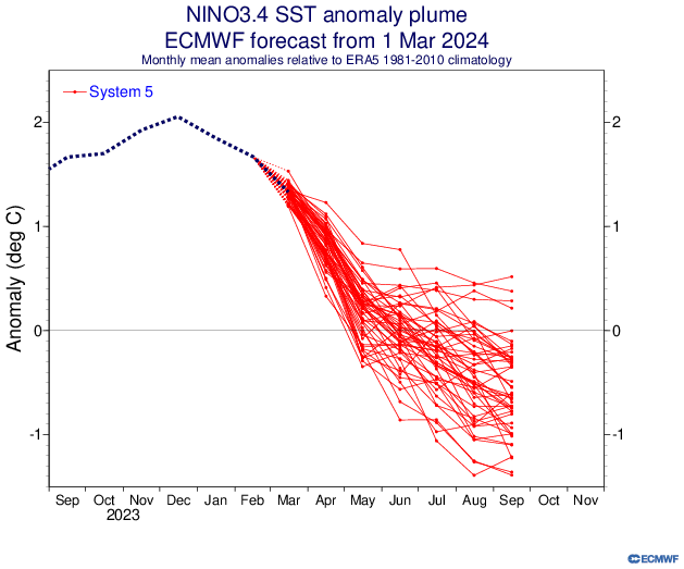
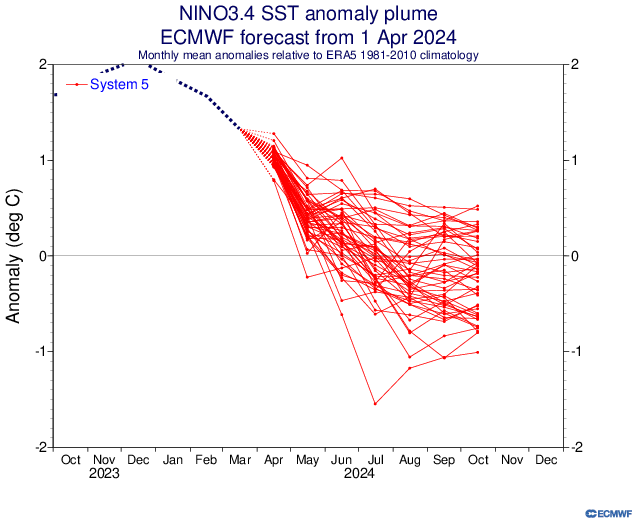
Fwiw, the April Plumes off of the SEAS5 (Euro) backed off a stronger Nina from March's plumes.
-
2
-
 1
1
-
-
6 minutes ago, Mount Joy Snowman said:
That cell sure looks like it's headed right for you and I. Unexpected.
Sky looking dark and angry to my north with mammatus clouds.
-
1
-
-
More development to my NW. Both Nams showed nothing. Lol
-
Sun's out. .32" in around 15 minutes.
-
4
-
-
Just crazy how heavy the rain is while I see blue skies a plenty to my north.

-
1
-
-
Just now, mitchnick said:
Ughhh...getting ready to mow after waiting for the grass to dry and now getting crushed by that renegade, heavy cell. Now I'm ticked.

P.s. Thunder too!
-
35 minutes ago, Itstrainingtime said:
Missing storms at home?
https://weather.cod.edu/satrad/nexrad/?parms=LWX-N0B-1-24-100-usa-rad
Ughhh...getting ready to mow after waiting for the grass to dry and now getting crushed by that renegade, heavy cell. Now I'm ticked.
-
 2
2
-
-
20 minutes ago, canderson said:
I have terrible internet that won’t load RadarScope here at DFW. Will that like clear Harrisburg by 10?
It should weaken by the time it gets to Harrisburg.
-
41 minutes ago, Mount Joy Snowman said:
Low of 54. Interesting couple of days on tap.
El Nino springs...they're to die for. Ughh
-
1
-
-
Late update. I had a total of 2.95" for the weekend. Adding to that the 1.2" from the prior week gives 4.15" as a 10 day total. Lake Codorus is back to normal.
-
2.55" yesterday and today thru 2:20.
-
24 minutes ago, Bubbler86 said:
The radar is fairly clear back to Western Ohio and Kentucky...in a PA context. The area in WV still headed mainly south of us as of now. Not doubt there will be showers and blobs of rain that pass or form, but I am not seeing any concentrated several hour strat rains the rest of the day. That 2-3 MORE inches of rain headline does not seem overly likely here. The main roads are dry down this way.
Unlike last summer, I keep getting hit by those convective isolated showers. But radar is finally looking to dry out shortly.
-
1
-
-
Thunder with that strong, short line moving thru here now. Nasty stuff in WV. Will it make it over the mts in similar intensity?
-
1
-
-
Pouring, but a break in sight.
-
Don't let Bliz see the Canadian.
-
1.3" on the dot here. I fertilized and put down a heavy load of Savin yesterday. Hopefully, the grubbs eat well tonight and die by Monday.
-
4 hours ago, Bubbler86 said:
GFS has a burst of snow your way shortly after lunch when the rain is ending.
Why do I look at my overgrown lawn in disgust and think of you? Don't answer that. It's a personal problem.
-
No power all along rt. 94 (main drag) thru Hanover and to the west on Elm Street (rt. 116). Fortunately, power at the house.
-
18 minutes ago, Blizzard of 93 said:
I need snow pics…. I’m in withdrawal!
Check out 12z Euro.
-
Now the sun is out with a heavier snow shower.
-
Snow showers here in the last 5 minutes and it's 45. Lol That's the winter of 23/24 for you.
-
1
-
2024-2025 La Nina
in Weather Forecasting and Discussion
Posted
There was speculation last fall that the volcano that ejected all that water vapor would cause a strong PV for the winter. That wasn't the case and it was below normal almost the entire winter. We'll need that again and hope for some weakening of the PDO to have a better winter. Worldwide ocean temps are going to be much cooler than last year which should help fwiw.