

jojo762
-
Posts
4,228 -
Joined
-
Last visited
Content Type
Profiles
Blogs
Forums
American Weather
Media Demo
Store
Gallery
Posts posted by jojo762
-
-
2 hours ago, okiestormgeek said:
A couple days ago I heard a lot of hype about potential severe weather on Friday the 21st here in the southern plains. Have model runs today backed off that?
Models still generally support severe weather somewhere across the southern plains on Friday. The extent of and location of any potential higher-end threats beyond a slight risk is still TBD.
-
Appears that the Comanche County supercell is weakening rapidly.
-
 1
1
-
-
1 minute ago, Jim Martin said:
Wall cloud being reported with the storm in Comanche County, KS.
Not too surprising... Basically the only storm thus far in that "sweet spot" for today that appears to have became well rooted to the boundary-layer.
-
 Mesoscale Discussion 0495
   NWS Storm Prediction Center Norman OK
   0332 PM CDT Sat Apr 15 2017

   Areas affected...Northwest Oklahoma and part of south-central Kansas

   Concerning...Severe potential...Watch likely

   Valid 152032Z - 152200Z

   Probability of Watch Issuance...80 percent

   SUMMARY...A severe-weather watch will likely be issued in the next
   hour, with tornado being considered as the watch type across
   northwest OK into part of south-central KS.

   DISCUSSION...Trends in visible satellite imagery showed sustained
   and deepening cumulus clouds in vicinity of the dry line from the
   northeast TX Panhandle through far northwest OK into the adjacent
   part of south-central KS (including the counties of Kiowa, Clark,
   and Comanche).  Surface temperatures near 80 F and into the 80s in
   the TX Panhandle have aided in weakening surface-based inhibition,
   while steepening deep-layer lapse rates and strong instability (up
   to 2500-3000 J/kg) will support storm development this afternoon in
   the discussion area.  This combined with effective bulk shear of
   35-40 kt and strengthening southerly low-level winds into the early
   evening, enhancing hodograph curvature, will favor supercells with
   large hail and a tornado threat.

   ..Peters/Thompson.. 04/15/2017
-
Today reminds me a lot of 5/23/16 with the supercell that went off near Woodward. Triple point is in the same area, winds will back late... just have to be patient.
Too bad tomorrow won't be like 5/24/16... That was a great day.
-
00Z GFS crashes the front from Wednesday's system much further south than any other run... which keeps the warm front much further south on Friday as well, which would suggest that any higher-end potential would be relegated to NE TX/DFW/red river valley instead of the I-35 corridor. Guess we'll see what the euro says. Still a week or so out, so obviously a lot will change and a lot of details have yet to be decided.
-
9 minutes ago, Indystorm said:
Yes, on occasion pattern recognition and parameters are such that you can identify a potential significant event a week out. It is interesting that the normally conservative SPC would highlight this 7 days out.
I was shocked honestly given the degree of model spread in location/timing. But outlook area can/will be adjusted as we progress.
-
1
-
-
SPC already including southern KS and central/eastern OK in a Day-8 outlook for Friday April 21st.
-
00z and 06z GFS produced some truly ridiculous soundings across Oklahoma on Wednesday... Euro shows something drastically different, so nothing to get too excited about *yet.*
-
00z GFS continues to be pretty solid for sunday. Hate that the LLJ is WAY veered, but shouldn't matter too much. Solid BL-moisture, strong/moderate instability, strong deep-layer shear, and more-than-sufficient low-level shear. Best thing though? Storms **should** be discrete per model QPF output. Little concerned that BL and low-level moisture may become a bit displaced from the DL though, owing to the veered low-level flow. Also a little concerned about potential VBV issues, in relation to storm mode.
-
Upper 50s/60 degree DPs starting to nudge their way into southern OK.
-
SPC upgraded to MDT risk for very large hail in southern Oklahoma. Also now a 10% TOR and 30% hatched wind risk.
-
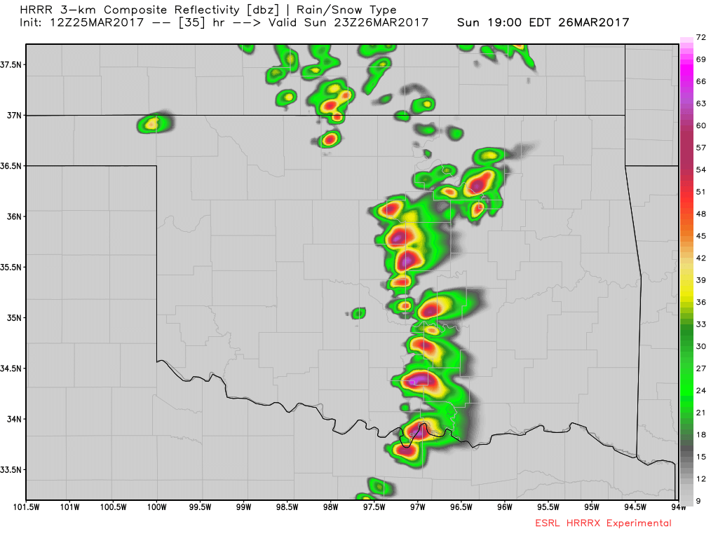
46 minutes ago, bjc0303 said:
experimental HRRR looks..active, you could say.

Good lord.... I'd have to figure that having six-plus discrete supercells like this would end up leading to a pretty prolific day tomorrow, especially if we pull off getting DPs of 60+.
-
00Z GFS is incredible for Sunday from southern Oklahoma through central Oklahoma into southern Kansas.
-
00Z GFS is highly volatile along and east of the I-35 corridor next Thursday in S KS into OK. Both deep-layer and low-level shear are very impressive, instability is more than adequate, and moisture is probably doable, not to mention that it develops numerous what I assume would be discrete supercells along much of the dryline. Not too sold on what the GFS is showing moisture wise though with DPs barely reaching 60 along a lot of the dry line. Guess a lot of that will depend on overnight/previous day moisture transport and how far the boundary earlier in the week dives south.
00Z euro is slower than the GFS and much further west with the DL, but also very impressive from what I can tell... should be a fun ride building up to this... impressive seven days out for a march system.
-
Excerpt from D4-8 outlook:
By Thu/D8, the trough and surface cyclone are forecast to deepen
   further, and at this point, appear to hold the greatest risk for
   severe weather. Moisture and instability will be a bit better than
   on the previous day, and the ECMWF shows a classic deep cyclone
   favoring all modes of severe weather, including tornadoes. However,
   predictability is low at D8, especially considering the current
   level of run-to-run model consistency. Thus, will defer to later
   outlooks for potential areas, which may eventually include the
   central and southern Plains, as well as the Missouri and mid
   Mississippi valleys.
-
7 hours ago, bjc0303 said:
Feeling pretty confident we are going to see a few severe events evolve over the next several weeks, starting somewhere around mid/late next week.
Certainly next week could get interesting.
The fact that the GOM will be open (at least the western half), and that we will we have southerly surface flow for days in advance is exciting... Still way too far out to determine very many details of any potential trough(s) though. Not a big fan of that H85 high that the GFS and Euro are showing over the western and north-central GOM though.
-
GFS seems to like the idea of an interesting system sometime around the 21st through the 23rd time frame across KS and the southern plains. Days of a relatively open GOM before hand would lead me to believe that moisture should not be too much of an issue. Biggest problem will probably be timing, as well as the potential for showers and crapvection in the warm sector.
-
That supercell W of SGF is incredible. Massive hail core.
-
13 hours ago, bjc0303 said:
Yeah, GFS has trended some better on instability into east OK with 1000 mlcape.
Still considerable spread among SREF members, as well as deterministic guidance.
Looking past Monday, still looks like potential uptick in severe next weekend/early next week.
For next weekend/ early next week, the GFS has been hinting at some days that would feature some pretty impressive conditions. Multiple waves coming through before the main dish. GFS has very little consistency with the main system, nonetheless timing is looking like it will be an issue. On a positive note, it does not appear that moisture will be an overwhelming issue, as of now.
-
SPC went with a broad brushed Marginal risk for Monday, which seems like a safe bet right now given wide model variability. Likely will see a slight risk later on. Given the strength of the wind fields, any forecast change in moisture quality/instability can alter the severe storm forecast drastically for any given area.
-
18 minutes ago, SluggerWx said:
Still a long way out, but the GFS hints at a potential midweek, multi-day threat across the plains in mid-March.
Sent from my Pixel XL using Tapatalk
It's been hinting at this for several days now. Has had trouble figuring out exactly what time period it'll occur though. Think it is safe to bet a strong system will be effecting the plains sometime during mid-march, moisture return/quality of course is the biggest question.
-
1 hour ago, bjc0303 said:
Although currently an outlier the NAM looks pretty potent for Monday evening across OK and central KS
Geez... I'd say so. Too bad it probably will not happen. 12Z NAM is about the best case scenario for severe storms/tornado potential that this system has.
-
Looks like Tuesday (2/28) is another potential event that fell apart as it got closer, basically nothing now on the models, at least for the plains. This was a theme last year, hopefully it doesn't become one this year.
Central/Western Medium-Long Range Discussion
in Central/Western States
Posted
Certainly is. Have to believe there is at least some potential for multiple days of severe weather during that time frame, perhaps a shot at a big-league day with the final (intense) trough.
Notable that this trough on Friday still has a decent amount of potential given its strength, just a few things going against it right now. 18Z GFS was interesting.