
OUGrad05
-
Posts
655 -
Joined
-
Last visited
Content Type
Profiles
Blogs
Forums
American Weather
Media Demo
Store
Gallery
Posts posted by OUGrad05
-
-
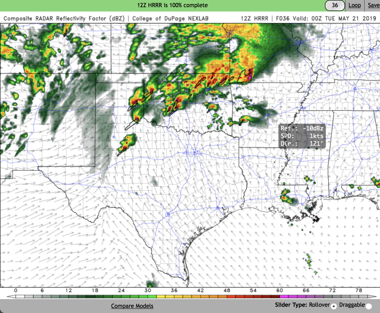
Monday has a really impressive synoptic presentation. There are always ways we can nit pick and say things aren't going to happen but at this point it appears that there will be tornadoes between the red river north to I-70 in KS. I also have some concerns about how late in the evening/overnight this could go. Right now this looks like a potent system through the overnight hours and possibility of multiple rounds of severe weather still exists. OKC, Tulsa, NW Ark, SW Mo could see issues overnight.
-
 2
2
-
-
Home from the chase. That stronger then expected cap put a damper on updrafts...
-
3 minutes ago, Quincy said:
As of 18z low-level lapse rates were anemic from far northeastern OK into southwestern MO. There still is some time to heat, so we’ll see...
A couple hours left to warm up still...
-
5 minutes ago, jojo762 said:
SPC upgraded to 10% hatched TOR risk across SE KS/NE OK/SW MO. Ingredients appear to be coming together for a potentially significant day across this region.
Yeah I agree, I can't see the update but was commenting to a buddy and put on my FB page I expect an upgrade to 10%. Not sure why I can't see it.
Claremore to Joplin to Springfield could have one or two strong tors today, perhaps a touch more with the triple point setting up the way it is. Don't want to hype but this is starting to get very interesting, especially with the better than forecast shear and solid sfc backing along and east of US169 -
7 minutes ago, Quincy said:
This. Watch temperature trends closely. HRRR is not far off as of 15z, just 1-2F too cool in parts of central OK. However, it may only take an extra degree or two of heating to break the cap. That’s what we saw happen on 4/28.
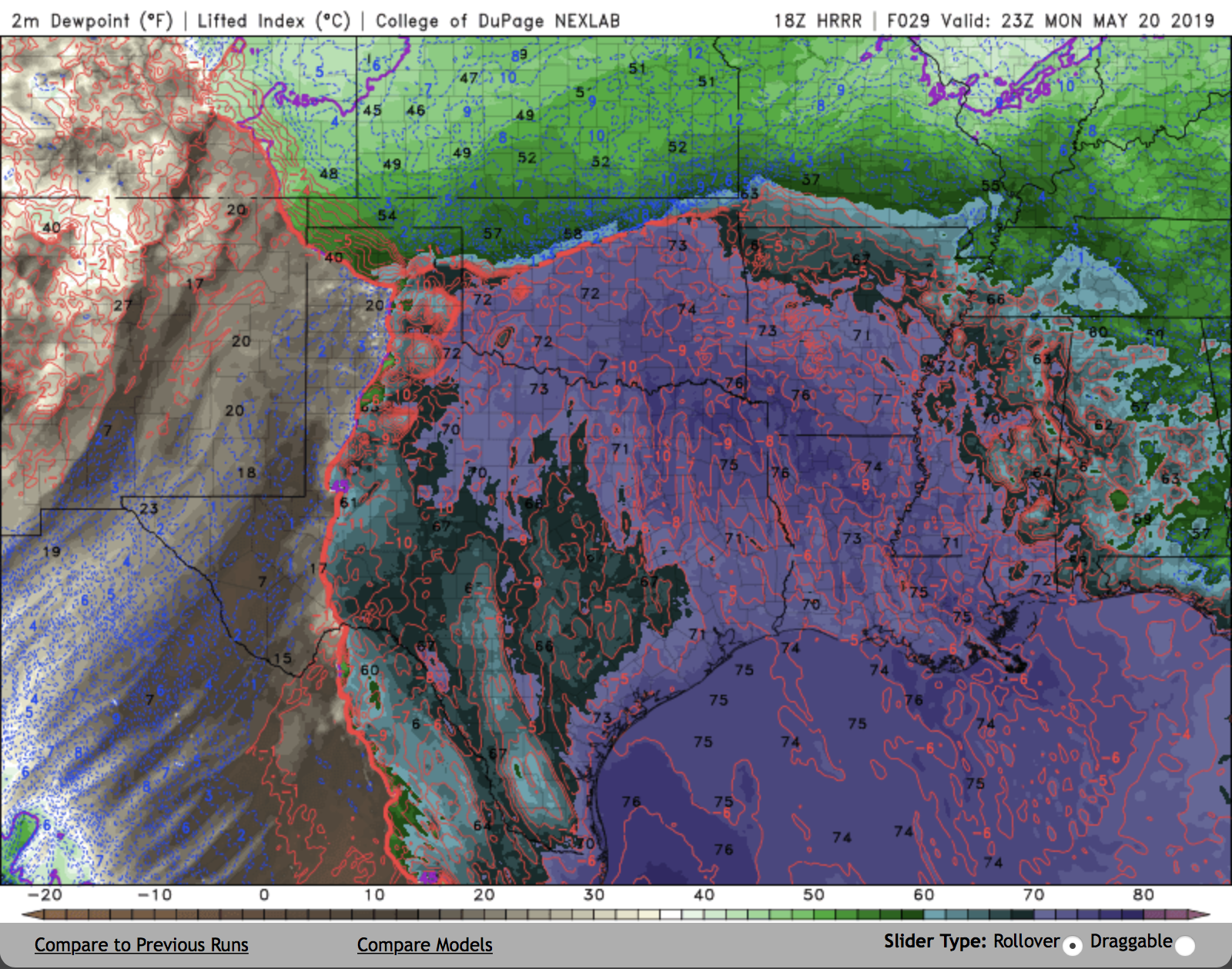
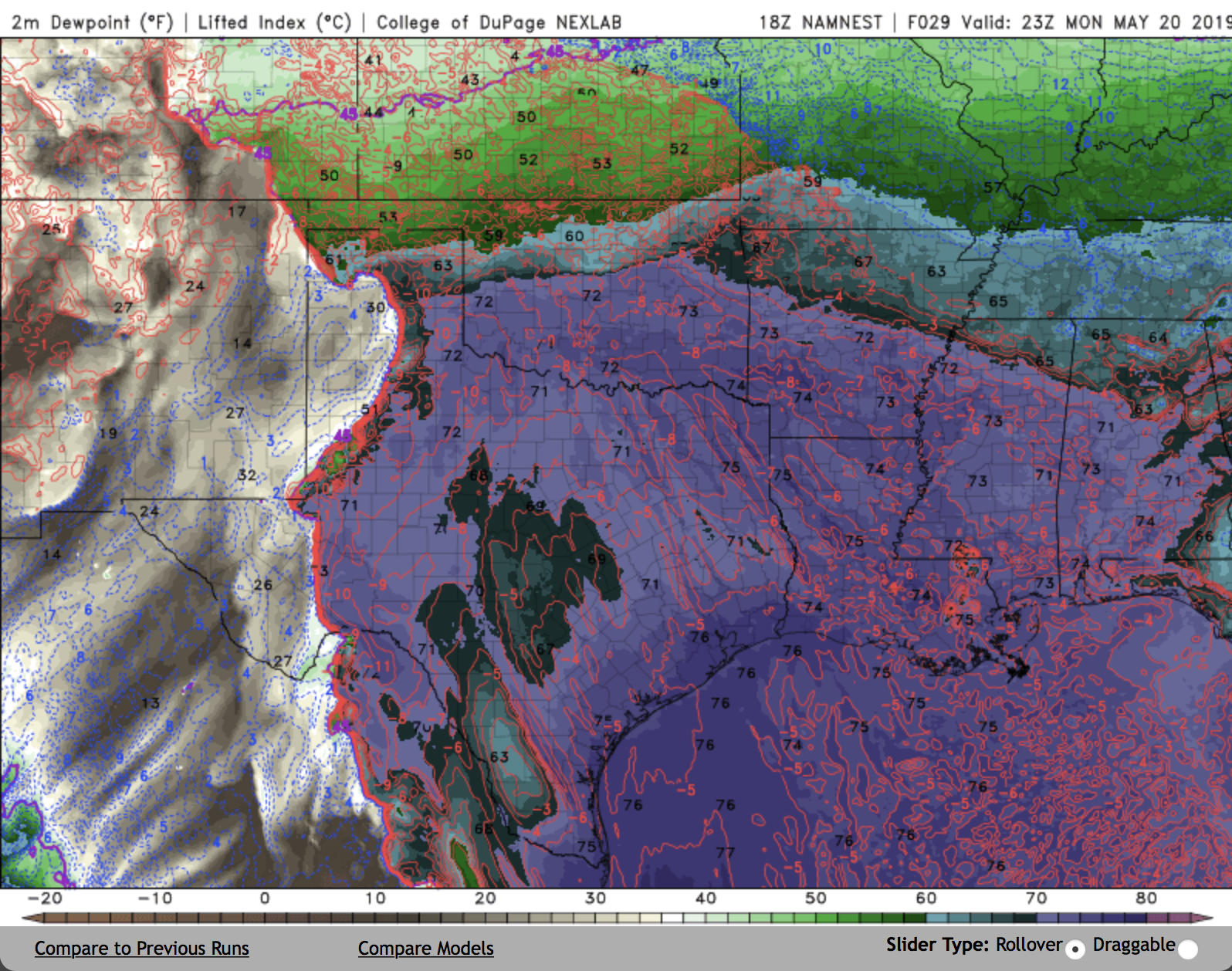
There's still some small but significant differences in the modeling of the SFC low, especially this afternoon between 3 and 6pm. That will have a huge impact on the populations impacted by the storm and the probs of tors. RAP is still showing some damn impressive hodographs over a decent chunk of eastern OK primarily north of 40. The HRRR has a touch more surface veering due to placement to the L and shear isn't quite a good. I haven't chased each model run but since yesterday afternoon the RAP seems to be holding pretty steady with HRRR and NAM drifting that direction a bit.
-
13 minutes ago, Quincy said:
Morning storms exiting NE Oklahoma are near an effective warm front. Elevated instability exists to the NE, while most surface-based instability is SW.
Note that the 700mb thermal ridge is over western OK at the moment. As it shifts east, storms lift into/through Missouri and capping takes over.
Morning storms have little to no impact on mid/late afternoon activity. Unless there’s some outflow boundary... Let’s say that scenario doesn’t reduce the severe threat.
Agreed sir.
Also, as mentioned above SFC backing is higher than was forecast yesterday. Haven't pulled models yet, busy working so I can chase this afternoon but a quick glance at the mesonet has me thinking tor threat may turn out to be a bit higher than the 5% currently forecast. -
10 minutes ago, Wx 24/7 said:
I am curious how the storms this morning affect the evolution of the afternoon/evening event. Will be interesting to watch. May 4th is a dirty word around here when you couple it with severe weather.
In OK they appear to be elevated SVR hailers so boundary layer will probably stay intact? Plus its early, sun is out, I'd expect a capping inversion to develop by mid/late morning?
If that doesn't occur and we remain uncapped it'll be a convective mess much of the day.-
1
-
-
9 hours ago, jojo762 said:
00z RAP verbatim show a high-end parameter space developing across SE KS/NE OK by as early as 20z tomorrow. CAMs provide a mixed bag of results for tomorrow, most which do not exactly show a high-end setup like the RAP -- especially with regard to convective evolution during the morning/afternoon and into the evening... but we'll have to see.
00z NAM also shows a higher-end parameter space developing, but with more capping in the afternoon prior to 00z... Somewhat concerned about lackluster low-level lapse rates, but we'll see how that evolves.
Yeah the RAP yesterday was impressive the NAM was absolute trash. I went to bed before the 00Z was available. I haven't looked at much this morning, just finished my workout and need to knock out a few things for the office then I'll start digging through the models.
-
Models right now are pretty inconsistent with hodographs and a few other parameters. RAP looks like we'll get an upgrade to 10% tor, NAM looks like an absolute mess with all kinds of VB and lack of flow at 850 and 700. Hopefully we have a better handle on it by in the morning. I definitely think we could get an ENH upgrade, may be for hail but we'll see tomorrow.
I also agree could be a sneaky day especially with this sfc low off to the west. -
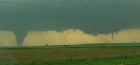
I was on mangum from the east. Really awful visability. I could see it through haze about 5-6 miles away eventually it moved to within a little less than a mile of us and then began to rope outLaverne getting a 1991 redux while the TX PH was getting an Allison/Kellerville redux. Those violent wedges tracking through the dusk and murk are scary...that's what most of us thought was gonna happen in spades last Monday. I was 2-3 miles from the eventual Mangum storm as it crossed US 62 near Gould and couldn't make out any definition of the updraft or what was going on under the base. It seemed those who got the tornado were those who got much closer and/or core punched, something I wanted no part of expecting tornadoes of the type above to get on the ground and stay on the ground, with Godzilla hail in the cores. -
20 minutes ago, jojo762 said:
Have been looking at Saturday for several days now. CAMs and HRRR point to what could be significant day across SW KS. Area INVOF the triple point will likely have volatile environment capable of all severe hazards, including significant tornadoes. Probably going out with some met students to near DDC then reevaluate satellite/obs from there.
Cams are all over the map right now. The 12Z stuff had dramatically different solutions even amongst the WRF family. HRRR was tor outbreak.
-
Tomorrow is starting to look pretty interesting. All the WRFs provide a different solution and HRRR is different still, but the environment in KS especially, looks rather potent.
-
1 minute ago, MUWX said:
Have 60% tornado odds ever been issued? Could we see them with the 3:00 update?
Yes they have
-
1
-
-
Gonna get real today
-
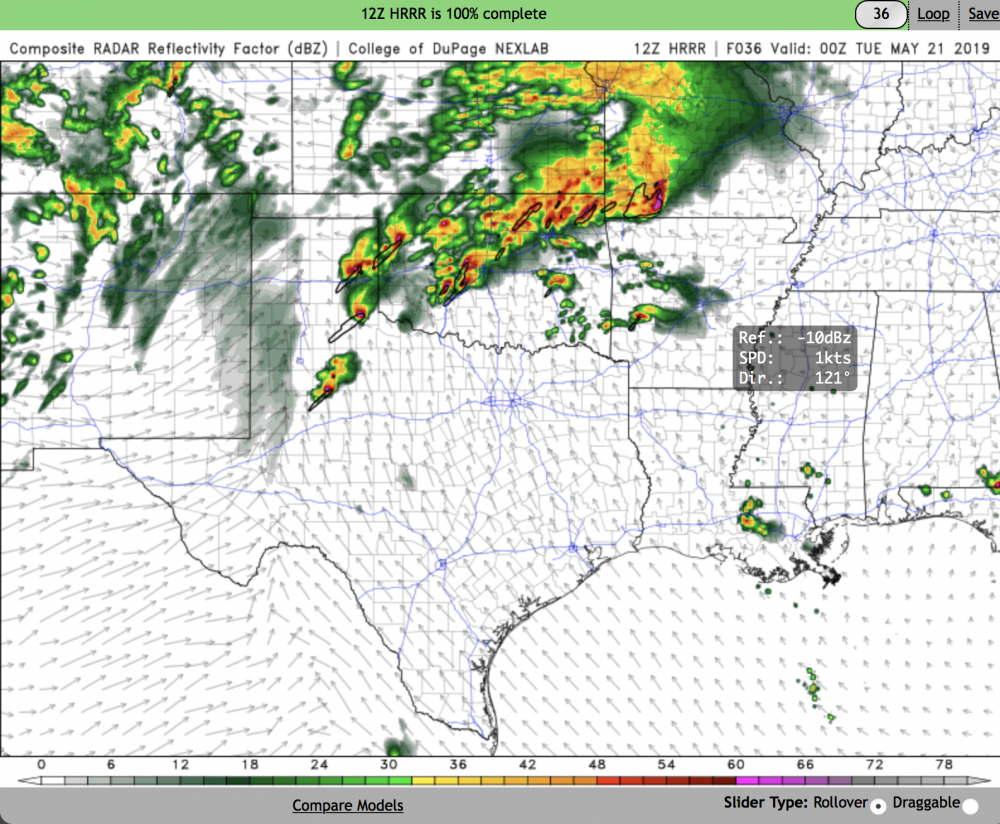
Interesting the HRRR is more aggressive than the NAM with pulling the front north.I think one of the primary differences between CAMs that show quick upscale growth and those that show a discrete outbreak is the orientation of the dryline in the TX panhandle. The NAM nest surges part of the dryline eastward and ends up with a SW to NE oriented dryline, which is close to parallel with storm motions. Since storm motion vectors end up parallel to the initiation mechanism, a squall line forms fairly quickly. The HRRR, on the other hand, keeps a more N-S oriented dryline and storm motion vectors are more perpendicular.
Subtle difference but it might end up being a big factor.


-
That is downright frightening for OklahomaFWIW, the 12 UTC HRRR is pretty much all discrete storm mode.
-
 1
1
-
-
New small enhanced risk in NW OK and S C KS.
-
Pretty much where I am. Convective overturning may be a problem as well as storm mode.I'll believe it when I see it -
It's not just this season it happens multiple times every year. A big difference with this particular system is we had fairly good agreement between models, analogs, etc and that stayed that way for several days. A lot of folks myself included took the bait. I am usually a 3 days out guy but the bait was just too good.These seemingly all fall apart this season the closer in they become. Today looks like maybe a few low end type tornadoes in W KS and plains of Nebraska.
-
Sights turn to Monday/Tues and maybe Thurs at this point. Watching another system crash and burn on itself is pretty frustrating. The plus side is we don't really need a major tornado running through the OKC, Tulsa or DFW metros, a few days ago it looked like a couple of these days would be high-end and have major metro areas in the risk zone.
Monday still holds potential to be high end but the details won't be clear until late Sunday or early Monday morning IMO.-
1
-
-
13 minutes ago, JMT417 said:
A little concerning to me is the SPC already hinting at upgrade to the Day 8 in later forecasts.
It's certainly interesting D4-D8 that's for sure. I'm not sure what to make of the D8 language. Obviously potential is there, but we've all seen systems just go to crap and sometimes evaporate that far out. This "feels" different given the magnitude of the data supporting the current forecast and wording.
Right now it's one day at a time for me, I'm not really analyzing models run-by-run at this juncture and don't plan to until we're within 3 or so days of each respective day on the outlook. Just simply too much movement, too much possibility for significant change that far out.
I will say I've not seen a pattern like this and models falling in line like this for so many repeated days in a long time, if ever. A big part of me says the system looks so good right now its bound to downtrend from here.
Soundings for Mon/Tues are just nuts.-
4
-
-
SPC now has an enhanced risk in the Eastern TX Panhandle, Western OK and W/C Kansas and into Central Nebraska. I'm not super impressed with the shear profiles on the GFS at this point, CAPE will be more than adequate to support big hailers. Plenty of time for GFS to come around a bit on the shear. It's adequate no doubt but not great. Euro looks more impressive.
Monday and Tuesday of next week look positively crazy.
-
2
-
-
On 5/12/2019 at 6:26 PM, jojo762 said:
As far as mid-long-range forecasting goes for chasers and enthusiasts, mid/late May this go-around looks potentially epic for just about anyone who enjoys severe weather. Multiple large troughs (leading to potentially BIG days, and also allowing for surprise "the day before the day" type events.)
Opportunities for severe weather appear to start this coming friday as the western CONUS trough begins to eject into a richly moist and unstable western/central plains atmosphere characterized by mid to upper 60s dewpoints and steep mid-level lapse rates, producing CAPE profiles upwards of 3000+ J/KG. Timing of the wave will be critical to how friday evolves. Given an amply strong low-level jet of 40-60kts (and 30-40kts by as early as 21Z), and favorably timed wave on the models, friday seems to have obvious severe weather and tornado potential.
Likewise, how Saturday evolves is heavily dependent on several factors: 1. Wave timing (and orientation), 2. convective evolution of previous day, 3. the potential for early-day convection that could washout the atmosphere. If the wave slows down a few hours (which would likely mean somewhat mitigated potential for Friday), Saturday has big time potential written all over it.
Sunday appears to be a lull day explicitly on the globals *as of now* which could change as the trough evolves throughout the next few days... Followed by potentially a day or two more of significant severe weather potential into the week of the 20th.
Important to not get too bogged down into too many details or specific model runs this far out, just watch for trends. Stay tuned.
Good call on Sunday, I'm now onboard with your position that it appears to be further east and not something I'm going to chase.
-
15 hours ago, jojo762 said:
As far as mid-long-range forecasting goes for chasers and enthusiasts, mid/late May this go-around looks potentially epic for just about anyone who enjoys severe weather. Multiple large troughs (leading to potentially BIG days, and also allowing for surprise "the day before the day" type events.)
Opportunities for severe weather appear to start this coming friday as the western CONUS trough begins to eject into a richly moist and unstable western/central plains atmosphere characterized by mid to upper 60s dewpoints and steep mid-level lapse rates, producing CAPE profiles upwards of 3000+ J/KG. Timing of the wave will be critical to how friday evolves. Given an amply strong low-level jet of 40-60kts (and 30-40kts by as early as 21Z), and favorably timed wave on the models, friday seems to have obvious severe weather and tornado potential.
Likewise, how Saturday evolves is heavily dependent on several factors: 1. Wave timing (and orientation), 2. convective evolution of previous day, 3. the potential for early-day convection that could washout the atmosphere. If the wave slows down a few hours (which would likely mean somewhat mitigated potential for Friday), Saturday has big time potential written all over it.
Sunday appears to be a lull day explicitly on the globals *as of now* which could change as the trough evolves throughout the next few days... Followed by potentially a day or two more of significant severe weather potential into the week of the 20th.
Important to not get too bogged down into too many details or specific model runs this far out, just watch for trends. Stay tuned.
You may be able to update that avatar pic sir! Take April 14th down and go with something else :)
I agree not to get too hung up on any one model run, look at the broader trends.
I do think its interesting that you think Sunday could be a lullday. I hope so since I have significant family obligations that day, but I'm not sold that's the case. In fact, I think it has rather high end potential S of I70 and along and east of 35 at this point. Hope you're right in this case sir.
Severe Weather 4-15 and 4-16-24
in Central/Western States
Posted
Meh, I don't really see that and global models trending down a little at this point? To be expected I'd say. This is still looking very dangerous.