

patrick7032
-
Posts
1,026 -
Joined
-
Last visited
Content Type
Profiles
Blogs
Forums
American Weather
Media Demo
Store
Gallery
Posts posted by patrick7032
-
-
On a side note, the King Salmon NEXRAD PAKC has been out of service for quite a while and needs major repairs. Apparently now it is a funding issue and may not be fixed until next fiscal year.....
NNIIICCCEEE....another reason why we should have an 88D here in Cold Bay....GRANTED population of 60 wouldn't justify it....but seeing we have a10,450+ foot runway that serves as a test strip for most commercial aircraft manufacturing companies like Boeing....the primary hub for the chain....an emergency landing location for ANC and trans-oceanic Pacific flights....not to mention the marine waters in my area serves as most of the Salmon and Crab Fishing grounds which is probably Alaska's 3rd of 4th biggest industry....it would be a good "heads up" for what is coming through based on radar and VAD winds....but oh well....what can ya do....budget issue.
-
Something you don't see every day. At first I thought it was erroneous but it was present for 4 or 5 out of 6 frames in the loop. What I'm talking about is the lightning strikes. In the Yukon of Canada okay no big deal it happens. But strikes near Barrow, Alaska over the Arctic Ocean....that was surprising and there was a system up there I believe but still HIGHLY UNUSUAL.
-
Just what the Juneau area doesn't need....more heavy rain....that area has already experienced a prolonged period of intermittent flooding and the pattern definitely supports them getting "clocked" once again. Granted it's still a ways out there in the forecast range but the models have been persistent in showing this.
-
Thank you,I also have a <a href='http://meteowhitehorse.ca/webcammeteowhitehorse.jpg' class='bbc_url' title='External link' rel='external'>webcam</a> and you can have links to some webcams in my area.About the weather here, we are on the way to fall now, with our first freeze beginning of August.It will soon by magic with all the colours from yellow, red and orange. A wonderful time which only lasts a couple of weeks.
Welcome to the board....this section of the forum should get more active with posts in the winter. I try to keep up here at least once a week though, as do some friends of mine.
-
Illiama, Alaska (SW of Anchorage/N of Kodiak) had a PIREP (Pilot Report) or a TORNADO yesterday in rural area....

-
Illiama, Alaska (SW of Anchorage/N of Kodiak) had a PIREP (Pilot Report) or a TORNADO yesterday in rural area....
-
Definitely been a warm 8 days in the Aleutian Island chain as that ridge built over us. A few obs are below along with a weather summary so far. The records are highlighted in red and near records in pink.
Cold Bay:
PACD 170053Z 18015KT 10SM FEW025 SCT140 SCT250 19/13 A2983 RMK AO2 SLP103 BCFG DSNT NW-N ALONG THE BERING SEA COAST T01940128
PACD 172253Z 17019KT 10SM FEW006 BKN016 BKN060 BKN130 17/14 A2979 RMK AO2 DZB19E25 SLP087 CIG LWR S-SW P0000 T01670144 $
King Cove:
PAVC 162356Z AUTO 11013KT 10SM CLR 18/13 A2987 RMK AO2 TSNO 58002 T01770133 10177 20144 SLP116 $
Port Heiden:
PAPH 172136Z AUTO 01006KT 10SM CLR 19/11 A2986 RMK AO1 PNO
PAPH 162356Z AUTO 34013KT 10SM CLR 18/09 A2989 RMK AO1 10180 20100 401800030 57010 PNO
False Pass:
PAKF 170101Z AUTO 18008KT 10SM OVC026 17/13 A2985 RMK AO2 SLPNO T01670133
Dutch Harbor:
PADU 172258Z 20006KT 10SM FEW008 BKN050 21/14 A2973 RMK AO2 SLP074 BP T02060144
-
A nice mid level trough will develop by early next week....if this verifies on SFC temp some areas along the western areas along the coast or in the chain may approach near record low max temps....if it verifies.
-
SXAK78 PACD 171245
RERCDB
RECORD EVENT REPORT
NATIONAL WEATHER SERVICE COLD BAY AK
445 AM AKDT WED AUG 17 2011
RECORD TEMPERATURE OF 68F WAS SET ON AUGUST 16, 2011. THE OLD RECORD
WAS 65F SET IN 1984.
$$
*** AUG 11
-
SXAK78 PACD 121156
RERCDB
RECORD EVENT REPORT
NATIONAL WEATHER SERVICE COLD BAY AK
356 AM AKDT FRI AUG 12 2011
...RECORD HIGH TEMPERATURE SET...
AT 4:59 PM AKDT THE TEMPERATURE AT THE STATE AIRPORT AT COLD BAY REACHED
67 DEGREES. THIS BREAKS THE RECORD OF 65 DEGREES SET IN 2001.
$$
JAP AUG 11
Believe we were close to a record during Friday too....I'm checking on this now....when I flew out to Anchorage Thursday it was definitely "toasty"....which 67 doesn't sound like much to people back in the lower 48, and sure there is acclimation involved, but with the high sun angle that felt like 77....could take another day or to like that....
-
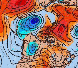
Nice 589dm ridge building into the Aleutians with a deepening trough in the Gulf of Alaska heading southeast.
-
Nice 589dm ridge building into the Aleutians with a deepening trough in the Gulf of Alaska heading southeast.
-
Nice story about the Glacial Flood in Juneau last month with other stories linked to the page. I know someone at regional who has great photos of the event which I will post later.
-
For those of you that wonder if tornadoes occur in Alaska, yup they do. This location is in my zone and have been told by the locals that funnels occur at times in Cold Bay. It's also amazing how high the surge can get if the earthquake occurs "in the right spot". These images were taken from material I'm reviewing which I received from co-workers.
-
Looks like the GFS has backed off the -2 to -4 C 850 mb temps it was outputting yesterday.
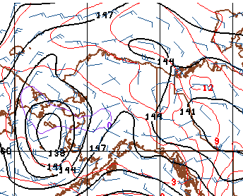
Not surprising considering the ridging/warm 850 T's (+12 C extending up into the Beaufort Sea) to the northeast cutting it off from any reinforcing cold air and a warm southwest flow behind the north Pacific ridge. Strange to think of a system being "cut-off" when it is on the polar side of the jet. This type of a pattern seems to favor climatology with a mean trough centered over western Alaska and the Bering Strait. You can see the July/Aug mean 500mb geopotential height pattern isn't too far off from what is happening now.
climo
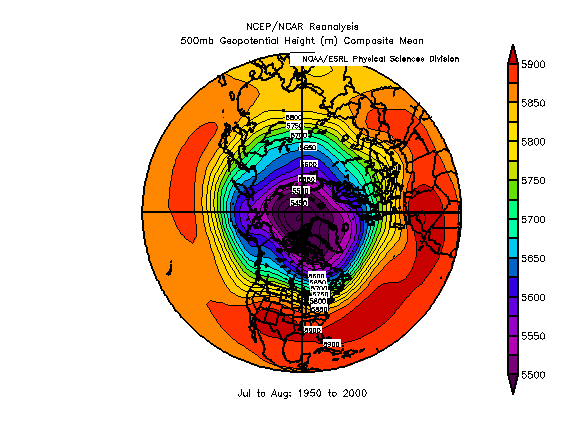
current
The major difference I see is the high latitude block over Greenland which has acted to shift the polar vortex toward the Chukchi/Beaufort Seas. This developing pattern is depicted well in the ensemble mean forecasts of several teleconnectors....
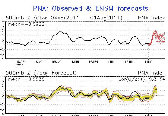
The progged positive PNA makes sense with the deepening low and embedded disturbances moving south into the Bering Sea will act to build the heights downstream over the intermountain west though I think the + phase is more related to the negative height anomalies over the Aleutians.
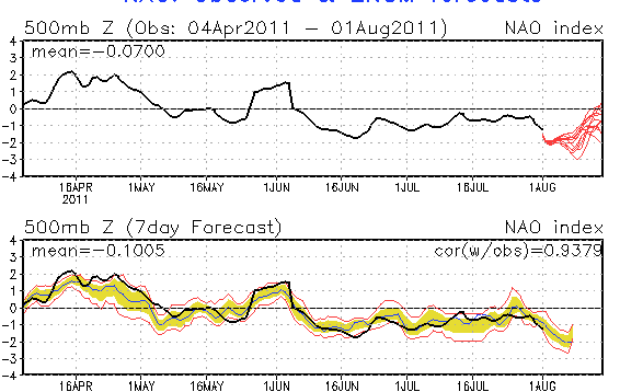
The negative NAO at the same times shows the developing positive height anomolies over Greenland.
All of these factors make for a cooler wetter period for southern Alaska. I am no teleconnector guru by any means, but just my take on the current pattern.
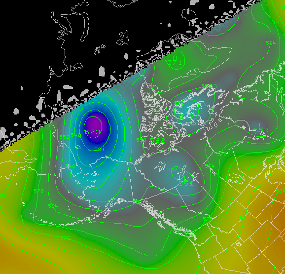
Yeah we even had a few sunny days this week and looks like a few more next week. Talk about a nice short wave ridge (see images). Will be interesting to see if one of these 500 lows head SE to the lower 48.
-
Thanks for starting this thread...good stuff.I hope you're both enjoying life in Alaska.
Thanks Beavis....I expect this thread will get a lot busier once the winter storms hit and we get HURRICANE FORCE WIND WARNINGS with 60+kt sustained zone forecasts with seas 30 feet plus. Until then will try to post few times a week with met data.
-
I see the GFS is progging the return of the 0 degree 850mb isotherm to southern Alaska. Nobody wants to see termination dust around here yet!
-
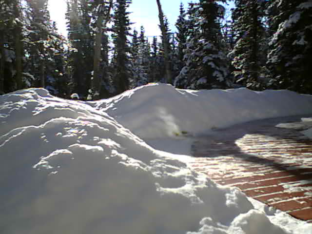
Some cool ACSL pics from 2 weeks ago....give it a few as internet is slow today.
-
Some cool ACSL pics from 2 weeks ago....give it a few as internet is slow today.
-
I see the GFS is progging the return of the 0 degree 850mb isotherm to southern Alaska. Nobody wants to see termination dust around here yet!
Yeah will post the data in a few....only have 256k speed here so may take a few to load images.
-
Started this thread to see how many people would be interested as we approach the winter storm season where HURRICANE FORCE WIND WARNINGS are not all that uncommon. I have also noticed that when we get a seasonally deep 500mb low dropping southeast up here as it tends to eject into the lower 48 active weather usually follows with decent severe weather outbreaks .
Alaska/Western Canada obs and discussion
in Central/Western States
Posted
I noticed the same thing....thinking the Aleutian Chain to about Kodiak and over to King Salmon in Alaska area may see 45-55 kts at sfc.