

patrick7032
-
Posts
1,026 -
Joined
-
Last visited
Content Type
Profiles
Blogs
Forums
American Weather
Media Demo
Store
Gallery
Posts posted by patrick7032
-
-
Sorry, I probably should have been more specific also. I'm talking about Vancouver Island when I say BC. Just looking for insight, I can look at data on different sites, but planning a trip like that I was hoping to get some insight from people more locally that know all the dynamics better. Thanks!
I believe November through February....but the bigger storms hit up here in the Aleutian Islands. Will check though for you for down there.
-
Yeah the ASOS here will remove the - sign whenever I add PL or GS....each machine has "it's own mind". I didn't COR it so I can show the techs and let them troubleshoot it.
7sm moderate snow?
-
Looks like more snow may be on the way....an exert from the morning discussion....
BERING SEA/ALEUTIANS...
POTENT VORTICITY CENTER WILL CONTINUE TO DIVE SOUTHEAST ACROSS THE
EASTERN BERING THROUGH THIS MORNING AND WILL ENTER THE NORTH PACIFIC
BY THIS AFTERNOON. EXPECT TO SEE INCREASED RAIN SHOWER ACTIVITY AND
COOLER AIR BEHIND THE SYSTEM AS IT PASSES. OTHERWISE...A SERIES OF
WEATHER FRONTS IN FAST SOUTHWEST FLOW ALOFT WILL BRING A RENEWED PUSH
OF GALE FORCE WINDS AND RAIN AND RAIN SHOWERS TO THE REGION FROM WEST
TO EAST AND PERSISTING THROUGH THE END OF THE WEEK.
.LONG TERM FORECAST...
THE PATTERN WILL TRANSITION FROM CLEAR AND DRY TO CLOUDY AND WET LATE
THIS WEEK...AND THEN PERSIST FOR THE MOST PART OVER MOST OF
SOUTHCENTRAL...ESPECIALLY CLOSER TOWARDS THE GULF...AS SOUTHWEST LATE
THIS WEEK GRADUALLY VEERS TO A MORE SOUTHERLY FLOW FOR THE EARLY TO
MIDDLE PARTS OF NEXT WEEK. A LARGE SCALE UPPER LEVEL TROUGH
EVENTUALLY BUILDS ACROSS THE BERING SEA BY EARLY NEXT WEEK...BRINGING
A BETTER CHANCE OF SNOW SHOWERS OVER PARTS OF THE BERING AND
SOUTHWEST ALASKA THAT HAVE YET TO SEE IT THUS FAR THIS SEASON.
OVERALL CONFIDENCE IS GENERALLY HIGH GIVEN THE GOOD MODEL AGREEMENT
IN THE SYNOPTIC PATTERN.
-
Well you knew it was a "matter of time". Had my first snow of the season as a heavier "convective" shower moved through and the winds kicked up from 13 to 33kt....as the shower "wet-bulbed" down some cooler air. Had a nice mix of rain, sleet, and snow for a little less than 10 minutes....no surprise though as earlier in the day we could see the "white haze" mixed in with the shower to the W-NW coming from a TCU and the freezing level dropped from 2100 feet during the day to 1900 feet on tonight's RAOB launch....and noticed an MCV dropping southeast with enhanced cloud tops on the IR SAT....obs are below....
 ....
....
PACD 111042Z 34014KT 10SM FEW019 BKN030 OVC065 03/01 A2993 RMK AO2 PK WND 33033/1023 RAE05B24E42SNB30E42PLB33E42 P0001
PACD 111033Z 34017G30KT 7SM SNRAPL SCT019 BKN026 BKN036 03/01 A2993 RMK AO2 PK WND 33033/1023 RAE05B24SNB30PLB33 P0001
-
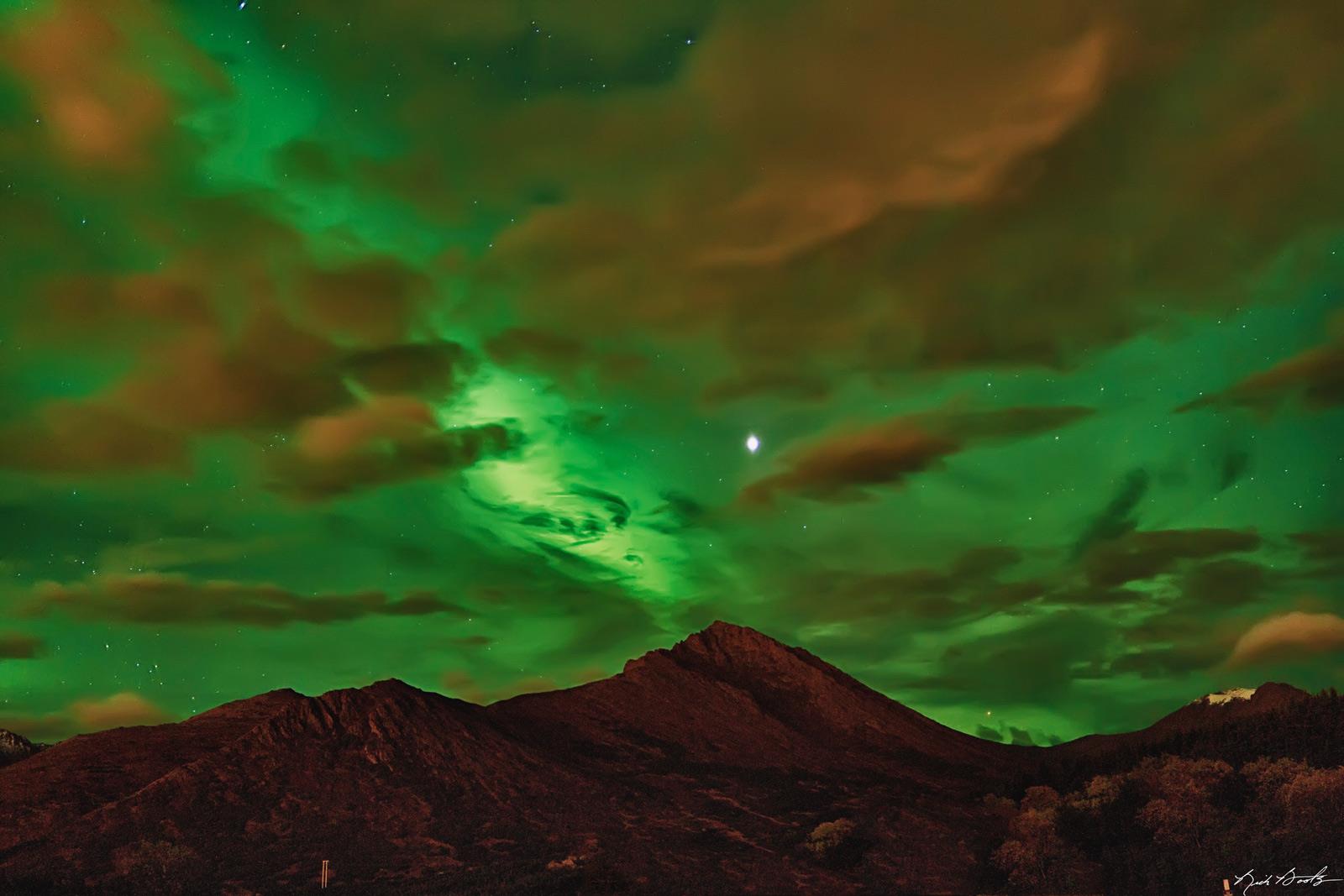
Hi everybody,
Mild day with windy and mainly cloudy conditions. Low of 2.7C, high of 11.5C.
Upcoming days should be wetter and cooler, rain and snow should be back as well as frost in the nights.
To end this post, here is a picture I took this night:
These were the most beautifull auroras since I settled two years ago
!
The other pictures are here : Meteowhitehorse
Very Nice....

-
The first outlook of the "DREADED "S" WORD. Not sure if it will occur though as temps remain realitively warm. We would have to "wet-bulb" down some of the cooler air aloft in a "heavier burst" of rain showers.
FPAK52PAFC_AKZ181
-----------------
AKZ181-080000-
ALASKA PENINSULA-
INCLUDING...COLD BAY...SAND POINT
500 AM AKDT FRI OCT 7 2011
.TODAY...MOSTLY CLOUDY. SCATTERED RAIN SHOWERS POSSIBLY MIXED WITH
SNOW IN THE MORNING...THEN ISOLATED RAIN SHOWERS IN THE AFTERNOON.
PATCHY FOG IN THE AFTERNOON. HIGHS IN THE MID 40S. NORTHWEST WIND 10
TO 15 MPH.
.TONIGHT...MOSTLY CLOUDY. A CHANCE OF RAIN AND SNOW SHOWERS IN THE
EVENING. PATCHY FOG. LOWS IN THE MID 30S TO LOWER 40S. VARIABLE WIND
10 MPH.
.SATURDAY...PATCHY MORNING FOG. PARTLY SUNNY WITH A CHANCE OF RAIN
SHOWERS. HIGHS IN THE UPPER 40S. EAST WIND 15 TO 30 MPH.
.SATURDAY NIGHT...RAIN LIKELY. LOWS IN THE LOWER 40S. NORTHEAST
WIND 20 TO 35 MPH EXCEPT EAST 10 TO 25 MPH SAND POINT EASTWARD.
.SUNDAY...PARTLY SUNNY WITH A CHANCE OF RAIN SHOWERS. HIGHS IN
THE UPPER 40S. NORTH WIND 10 TO 25 MPH.
.SUNDAY NIGHT...MOSTLY CLOUDY WITH A CHANCE OF RAIN AND SNOW SHOWERS.
LOWS 35 TO 40.
.COLUMBUS DAY THROUGH WEDNESDAY NIGHT...MOSTLY CLOUDY WITH A
CHANCE OF RAIN SHOWERS. HIGHS IN THE MID 40S. LOWS 35 TO 40.
.THURSDAY...RAIN SHOWERS LIKELY. HIGHS 45 TO 50.
&&
TEMPERATURE / PRECIPITATION
COLD BAY 47 35 48 / 30 0 50
SAND POINT 47 40 48 / 30 0 40
-
A sign of THINGS TO COME....
 ....
....
-
Climate summary for Cold Bay is listed at the web link below. Although not listed in the summary, a FUNNEL CLOUD was observed on the 10th of Sept.
http://www.arh.noaa....?wmo=CXAK58PACD
A slightly "more detailed link is listed below.
-
Not something you see everyday in an observation up here....had to issue a short term forecast for it....
PACD 032014Z 27019KT 10SM -RA FEW015 BKN033 OVC044 07/06 A2942 RMK AO2 PK WND 26027/1955 RAB1954GSB09E14 VIS LWR SW P0000 $
PACD 032009Z 27018G25KT 10SM GSRA SCT025 SCT032 OVC044 08/06 A2942 RMK AO2 PK WND 26027/1955 RAB1954GSB09 VIS LWR SW P0000 $
FPAK78PACD_AKZ181
-----------------
AKZ181-040200-
ALASKA PENINSULA-
INCLUDING...COLD BAY...SAND POINT
1210 PM AKDT MON OCT 3 2011
.NOW...
NUMEROUS RAIN SHOWERS WILL CONTINUE ACROSS THE ALASKA PENINSULA
THROUGH LATE AFTERNOON. RAINFALL AMOUNTS THROUGH 4PM WILL BE LESS
THAN 0.1 INCHES. SOME SMALL PEA SIZE HAIL MAY OCCUR IN THE HEAVIER
SHOWERS ESPECIALLY IN WESTERN AREAS OF THE PENINSULA.
-
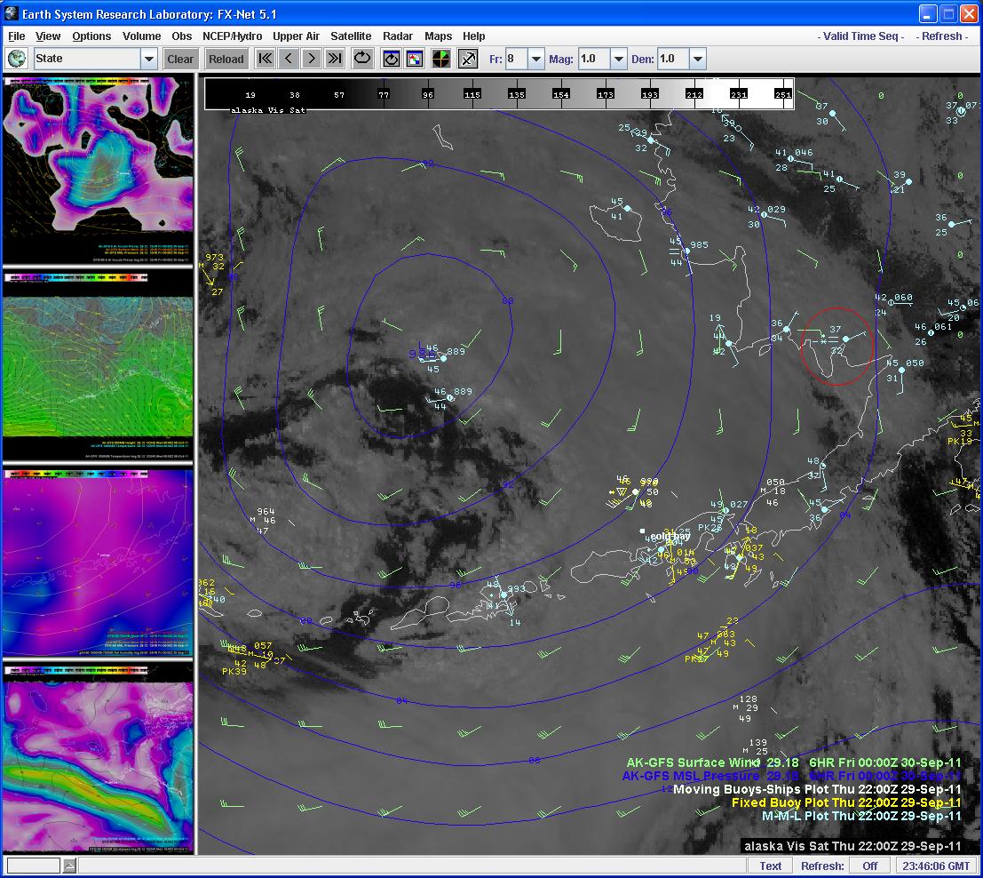
awesome vis sat view of the big system off the coast of BC
Nice Image....
-
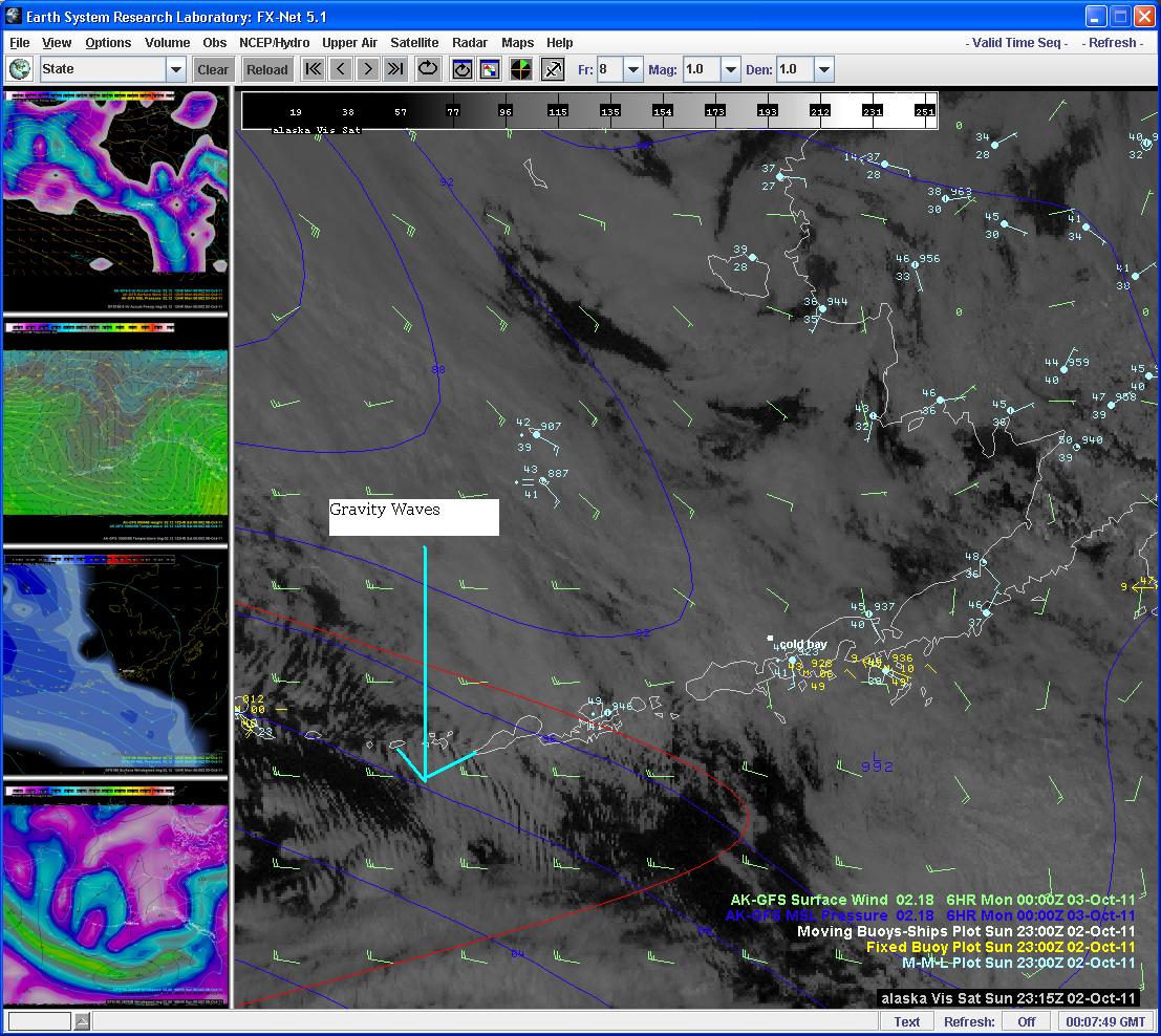
Nice visible sat pic showing some gravity waves....possibly as a result of the STRONG incoming low.
-
what a great thread!
Thanks OL....
-
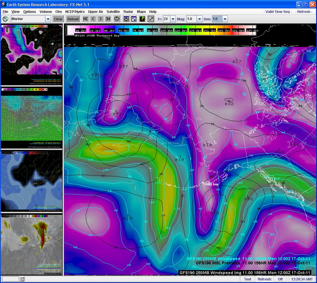
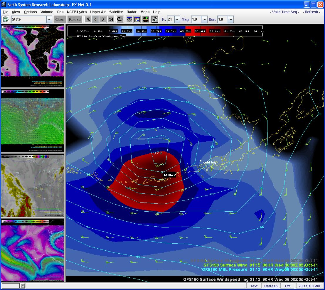
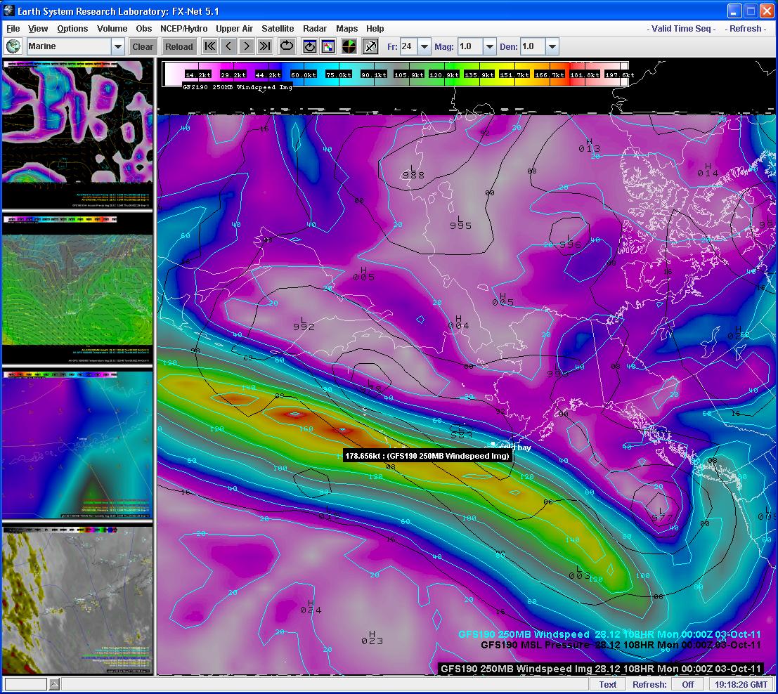
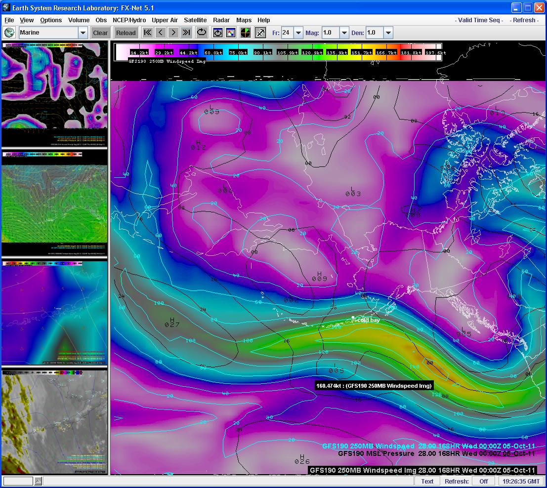
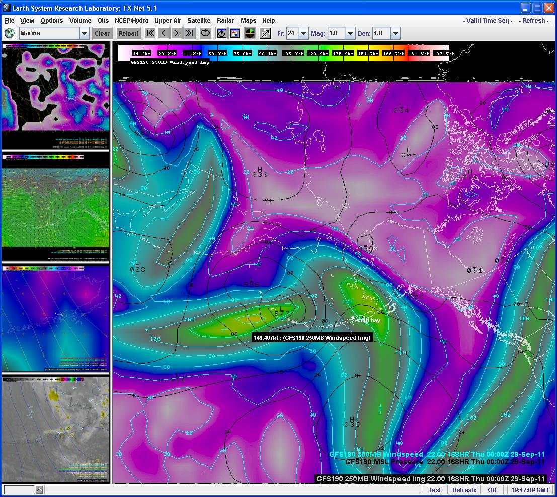
It looks like a couple of good storms will hit the Alaska Peninsula and Aleutian Island chain next week. Below is an exert from this mornings forecast discussion from the Anchorage Forecast Office and a "sample" marine zone for one of the effected areas. Note the 60kt+ winds in the model data for the middle of the week. The jet pattern certainly supports it. Looks like the jet pattern will stay "active" through the week. We may have a storm with HURRICANE FORCE WINDS by mid week. A sign of things to come in another month when the "real" storms start to "spin up"....
.....ALEUTIANS...A POTENT LOW PRESSURE SYSTEM AND ITS LOW LEVEL JET HAVE
ALREADY SUPPORTED WIND GUSTS ABOVE 50 MPH AT SHEMYA EARLY THIS
MORNING. WHILE THIS LOW WILL MOVE SLOWLY EASTWARD FROM THE KAMCHATKA
PENINSULA OVER THE NEXT FEW DAYS...ITS ASSOCIATED FRONTS WILL BRING
STRONG GUSTS ACROSS THE BERING BY THIS EVENING. THE MORE POTENT
STINGER JET ALONG THE SOUTHERN SIDE OF THE LOW WILL BRING STORM FORCE
WINDS TO THE WESTERN ALEUTIANS BY SUNDAY AND CENTRAL ALEUTIANS BY
SUNDAY EVENING.
PKZ176-020300-
WESTERN ALEUTIANS KISKA TO ATTU
400 AM AKDT SAT OCT 1 2011
...STORM WARNING SUNDAY...
.TODAY...SW WIND 45 KT. SEAS 13 FT. PATCHY FOG.
.TONIGHT...SW WIND 45 KT. SEAS 21 FT BUILDING TO 28 FT AFTER
MIDNIGHT. PATCHY FOG.
.SUN...SW WIND 50 KT. SEAS 33 FT. PATCHY FOG. RAIN SHOWERS.
.SUN NIGHT...W WIND 45 KT. SEAS 33 FT.
.MON...S WIND 25 KT. SEAS 20 FT.
.TUE...W WIND 30 KT. SEAS 16 FT.
.WED...W WIND 20 KT. SEAS 9 FT.
-
ALASKA VOLCANO OBSERVATORY WEEKLY UPDATE
Friday, September 30, 2011 11:00 AM (Friday, September 30, 2011 19:00 UTC)
CLEVELAND VOLCANO (CAVW #1101-24-)
52°49'20" N 169°56'42" W, Summit Elevation 5676 ft (1730 m)
Current Volcano Alert Level: WATCH
Current Aviation Color Code: ORANGE
The eruption of a lava dome in the summit crater of Cleveland Volcano continues. Satellite observations over the past week detected elevated surface temperatures at the summit on September 23 and 28 and slow growth in the size of the dome. As of September 26, the lava dome was entirely contained within the summit crater, approximately 15-20 meters (49 to 66 feet) below the eastern rim. AVO has received no other reports of activity at this volcano.
If the lava dome continues to grow in the summit crater, the possibility of an explosive event increases. With continued lava dome growth, lava may eventually overflow the crater rim to produce a lava flow and/or collapse to produce pyroclastic flows. Sudden collapse of the effusing lava could result in the generation of a volcanic ash cloud. However, lava may continue to erupt without an explosive event. It is possible that explosions from the summit crater vent could produce ash clouds that may exceed 20,000 ft above sea level. These events can occur without warning and may go undetected in satellite imagery for hours. However, lightning associated with significant ash-producing events may be detected within minutes using an automated alarm system.
AVO does not have a real-time seismic network on the volcano and thus we are unable to track local earthquake activity related to volcanic unrest, provide forecasts of eruptive activity, or confirmation of explosive, ash-producing events. In the event of a large explosive eruption like that in 2001, it is possible that seismic signals may be recorded on AVO seismic networks at nearby volcanoes. AVO will continue to monitor the volcano using multiple sources of satellite lightning detection, and distant seismic data.
Cleveland volcano forms the western half of Chuginadak Island, a remote and uninhabited island in the east central Aleutians. It is located about 75 km (45 mi.) west of the community of Nikolski, and 1500 km (940 mi.) southwest of Anchorage. The volcano's most recent significant eruption began in February, 2001 and it produced 3 explosive events that produced ash clouds as high as 12 km (39,000 ft) above sea level. The 2001 eruption also produced a rubbly lava flow and hot avalanche that reached the sea. The most recent minor ash emissions were observed in January and June 2009.
-
The clouds keep "teasing me"....have a TT of 57 and SI of near 0 (have learned <+4 is good for thunderstorms in Alaska)...so had some TCU's develop into CB's.
PACD 301918Z 30015KT 8SM SCT015CB BKN030 OVC080 07/06 A2926 RMK AO2 RAB02E17 CB W MOV SE TCU N BINOVC NE-SE P0000
PACD 301911Z 30014KT 6SM -RA BR SCT015TCU BKN025 BKN080 BKN180 07/05 A2926 RMK AO2 RAB02 TCU NW-N P0000
-
It's getting closer to that time of year.....here is an exert from this morning's discussion from the Anchorage Forecast Office which verified in lower elevations as well in southwest Alaska at Dillingham.
.SHORT TERM FORECAST...
.SOUTHCENTRAL ALASKA...
SHOWERS/RAIN AND SOME MIX OF SNOW(HIGHER ELEVATIONS) WILL SPREAD
ACROSS SOUTHCENTRAL TONIGHT AS THE UPPER TROUGH MOVES EAST. PATCHY
FOG AND STRATUS WITH SUBSIDENCE ON THE BACKSIDE OF TROUGH MAY FORM
OVER COOK INLET LATE TONIGHT/EARLY FRI. FRONT MOVING IN FROM THE EAST
AND SOUTH WILL BRING RAIN TO COASTS FRI AND SAT...WITH SOME SHOWERS
INLAND. EXPECT THAT THE STRONG WINDS OVER THE GULF FRI MORNING WILL
SPREAD TO THE NORTH GULF FRI EVENING AND CONTINUE INTO SAT.
PADL 292147Z 06006KT 6SM -RA SN BR FEW018 OVC022 03/00 A2971
PADL 292125Z 08006KT 8SM -RA SN BKN024 OVC034 03/M01 A2972
-
Beautiful Patrick, thanks for sharing !
Glad you enjoyed the pic and that my college in Anchorage was able to capture such a beautiful pic.
-
A college of mine in Anchorage posted this pic of the northern lights from last night. Great Pic....
-
The pattern is looking to amplify as we head into the upcoming week. A strong jet develops which looks like it could dive into the Pacific Northwest in a week to 10 days.
-
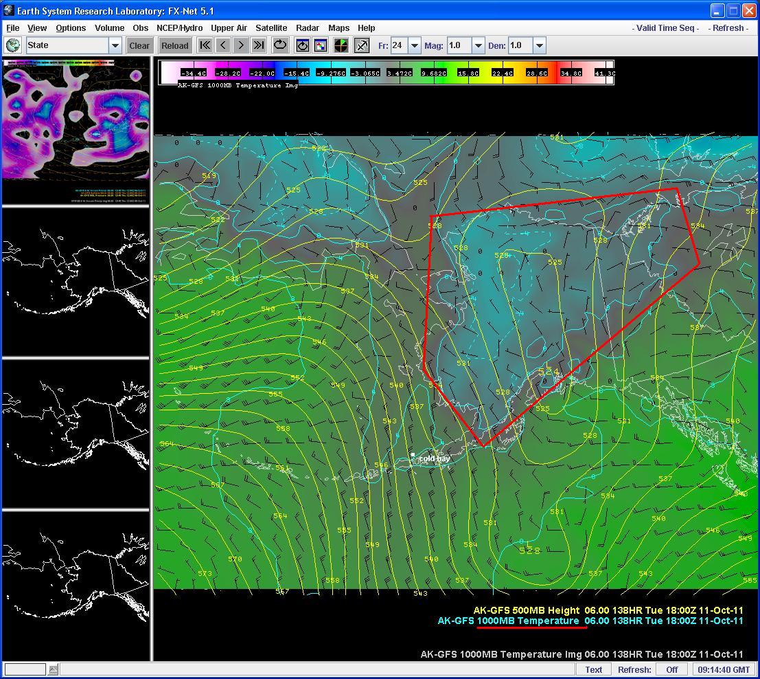
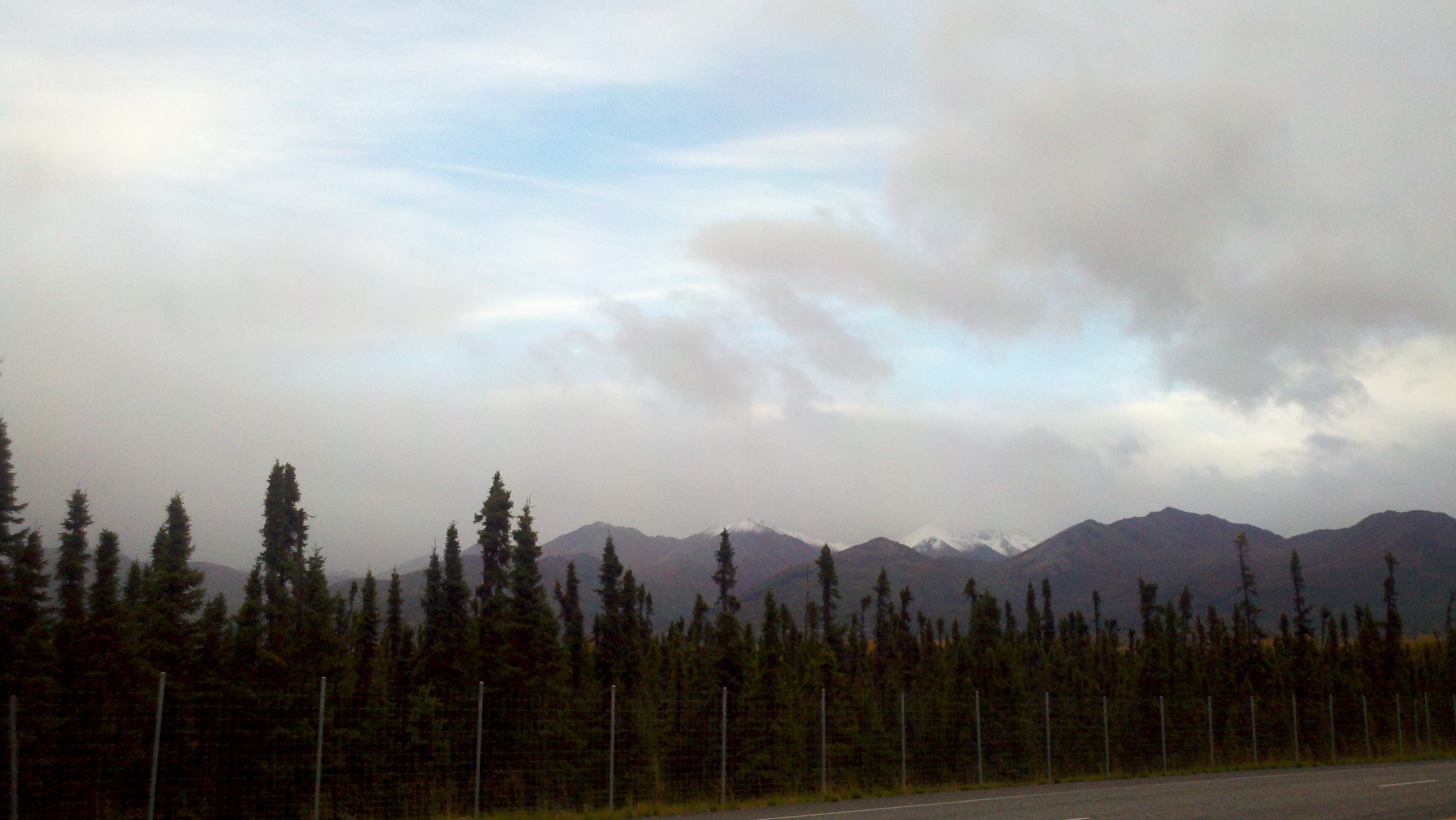
The persistent troughing over the Aleutian chain is showing it's effects....snow levels have dropped over the last couple days from ~4800 feet to ~1000 feet. Will post pics later of Frosty Mountain which looks like it may even be under the 1000' level. Also unless we hit 47 sometime today we will have tied a record low max of 46 going back to 1970 I think.
-
Pattern looks like it will "re-load" somewhat and even amplify next week.
-
I think were talking about 2 different systems. I was reference in the developing low in the Northeast Pacific.
Ahhh....okay then yes we are....but models off by the same amount you mentioned with the eastern Bristol Bay low....how ironic...same error deviation two diff systems.
-
We got our first real termination dust on the front range the other night. The closest peaks to Anchorage didn't get much, they are only around 4000-4500 ft, but directly behind there are some 5000-5500 peaks which did get hit. Freezing level on today's 12Z sounding was 5200ft. Winter is coming.
To "echo" your point...we've been running 2800 feet MSL on our FRZ heights last 4 launches.
-
It is well known that models struggle with rapid cyclogenesis events. The model guidance performance with the developing system has been erratic with the depth/placement/timing of the system approaching the AK Panhandle. Even this morning as the low is taking shape, and the models seem to have converged on a solution. Looking at the satellite can give us hints on how the models are actually doing.
Looking at the IR at 15Z today with the nam12 mlsp overlaid it appears to me as if the surface low is too far south and should be 3 degrees or so further north and maybe a little east. With a developing/mature cyclone the surface low is located to the east of the 'cusp' (the dry intrusion) in the satellite imagery.
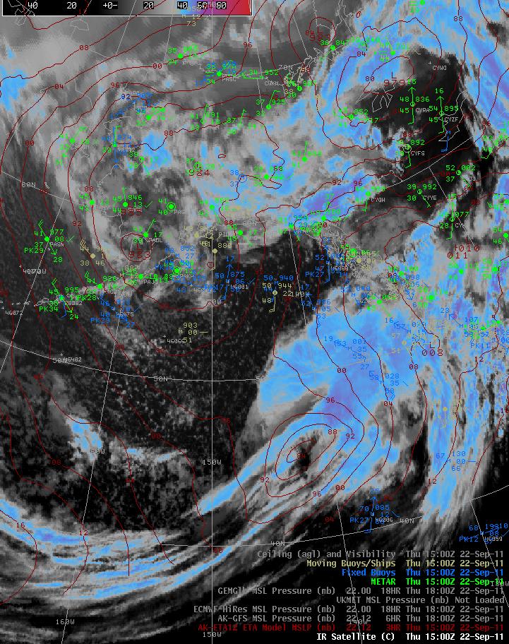
I agree....spot on....if you loop the IR sat you can clearly see the remnant circulation about 50NM SE of Cape Newenham.
Alaska/Western Canada obs and discussion
in Central/Western States
Posted
Here is something you don't see often in the FAR WEST END OF THE ALEUTIAN ISLANDS....let alone over a 2 by 4 mile sized island....
PASY 192356Z 27012KT 10SM -TSRA SCT021 BKN026CB 06/04 A2921 RMK AO2 PK WND 30029/2333 TSB52RAB22 SLP892 T00560039 10089 20044 52002 $
That is Eareckson Air Station west of Dutch Harbor.