
Fantom X
-
Posts
858 -
Joined
-
Last visited
Content Type
Profiles
Blogs
Forums
American Weather
Media Demo
Store
Gallery
Posts posted by Fantom X
-
-
81.5 yesterday- wasn't expecting another over 80
A whopping 0.05" of rain between yesterday and today.
Haven't had any significant rain since 9/9
Tree leaves are drying out further
We'll probably have early drop off, more as a result of dryness than standard fall leave color change
-
80/53 split today. maybe the last of consecutive 80s til spring? (7 in a row)
-
Hi All - A little late on the anniversary - but i finally got the chance to upload the home video that my father took of the hurricane- with us KIDS playing in the hurricane after the rain subsided and the sun came out- cuz, you know, Gen X was able to play in Hurricanes. Enjoy..
-
 6
6
-
-
My type of weather this week-
today - High - 83, low 56
-
still very dry over here- could use the rain - but a beautiful day
High - 81
Low - 57
-
MBY stats for Sept
Dry month in my area - less than 0.40" from the 13th to the end of the month
some trees are starting to dry out and drop their leaves early
High Low Average Temperature 95.9 °F 50.5 °F 70.1 °F Dew Point 79.5 °F 50.2 °F 64.7 °F Humidity 99 % 38 % 85 % Precipitation 1.68 in -- -- -
cool n cloudy day today - high 67, low 60
-
82/62 split on the day. Quite the perfect day today.
-
What's the record for consecutive lows above 70 in September? I see ISP has 7 consecutive days so far this month - that would be impressive for July IMO
to put it in perspective- i haven't had any lows above 70 this month down here..
-
Briefly went above 90 for 25 minutes today. Clouds starting to increase dropping the temp
Now 87/68.
-
4 hours ago, WestBabylonWeather said:
Of course I get the bad ambient. I need to figure out how to calibrate it
.The best time to compare IMO is at night during a cloudy, breezy evening with other surrounding stations. Then you'll know if it is only higher during the day, it may be a placement issue.
-
 1
1
-
-
High. 95.9 today on my ambient. Currently 89.1. 76 dew.
-
It's a hot one today. 94/75 currently as of 4:50pm
-
88/65 p cloudy- hoping the pop up storms hit later this afternoon
-
1 hour ago, GaWx said:
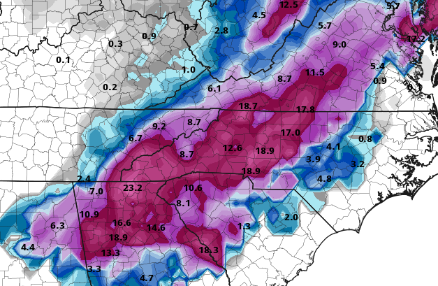
Fantasyland 12Z GFS Miller A GOM snowstorm very late 3/21 to early 3/23. Almost entire N half of GA to NW SC to W 2/3 of NC to most of VA gets several inches. Shades of 3/24/1983. Mainly for entertainment but there is still that second batch of cold coming per model consensus and it looks to be coming in with more moisture to play with instead of plunging down like the first one in a few days. This is the extreme of extremes of what can happen.
12Z ICON also has a GOM Miller A but two days earlier. Some snow from that west of the SE US on 3/19.
Lock it in!!
-
2
-
 4
4
-
-
high 79
low 58
just another warm day on the last day of meteorological winter
-
low 45 high 76
-
As AGW progresses, one item I find interesting (at least from my vantage point) is that as temperature averages increase, we still are maintaining the growing zones over the past decade or so with these cold blasts still happening. This may, in the future, lead to early starts to growing seasons only to have it damaged by an spring arctic outbreak- which I know happened recently in 2020.
-
1
-
-
Hi All
So I've always wondered why the averages the way they are. I think they should be broken down by specific pattern.
For example-
What would the average high in January in NYC be for all El Ninos, La Ninas? Average high for all -NAO, Average high for a sunny day, average high for a cloudy day?
So it NYC has a +3 day, but we're in a Nina pattern, what is the average during La Nina on a cloudy day? It may be a degree warmer? or cooler?
Maybe that' asking a bit much but what are your thoughts on this?
-
1
-
-
1 hour ago, WinstonSalemArlington said:
60?!
Yup. But as Temps rise outside, heat pump getting warmer. Now up to 66. It's just a heat pump system that I think is just enough up to code ( it's a new development) where it works fine if the temperature is over 25. Builder went as low cost as possible.
-
1
-
-
Got down to 7 here. Heat pump struggling to maintain 60.
-
22/1 - sunny at 4:30pm -pretty much a steady decline all day.
-
1
-
-
47.5 at 6:05am. Down to 31 at 8:30am.
-
Today is the anniversary of the 2009 blizzard. It was the largest total I received locally in Shirley NY at 21" between 2009-2018
-
1
-
1
-
October 2023 Stats
in Southeastern States
Posted
Down to 36.5 this morning.