

mclean02
-
Posts
217 -
Joined
-
Last visited
Content Type
Profiles
Blogs
Forums
American Weather
Media Demo
Store
Gallery
Posts posted by mclean02
-
-
Took this from the Mid Atlantic forum theres hope for GSO nc lol
-
Wow it is coming down and blowing around here in downtown blowing rock I love it !!
-
 1
1
-
-
Nothing but rain in blowing rock atm
-
Thank you all for the advice booked a room in Blowing Rock can't wait for the snow
")
-
2
-
-
1 hour ago, Hvward said:2 hours ago, Met1985 said:This is an airmass we could see diamond dust falling in. Been awhile since we have seen that.
Yeah the dendritic growth zone is going to be between 4500’-7000’ on Xmas Morning. The flow could continue on into the morning on For many. Snow showers will make themselves with the growth zone that low.
Was thinking about booking a place in boone but not sure if I should pick there or banner elk for my first snow ❄️ tracking of the year. Does anyone know which is best for nw flow snow ?
-
QQ. all i want to see snow this weekend was thinking about staying at Banner Elk this Sunday to Monday should i change the location ? Is 3700 feet high enough will i need to look at Beech Mountain or move the date to Monday to Tuesday sorry to ask just wondering thanks everyone !
-
1 hour ago, FLweather said:
Honestly you cant say for sure. Neither can I.
Its 2020 after all.
Jan 25 2000 redux maybe in store. 20 years later.
I'm torn between laughing at you and giving you a weenie.
Would be great to see that hopefully we can get in the snow this year !
-
Sorry to bring back an old tread but just saying the one year in my life that move to Charlotte.. Greensboro finally gets a huge snow lol I hope we get something like this in 2020
-
1
-
-
Snowing in north Greensboro nc
-
20 minutes ago, WinstonSalemArlington said:High-latitude N Pacific blocking, SE Canada vortex, & an active southern stream are the basic large-scale ingredients that favor wintry wx in the southern US & they might be in place next week. However, timing will ultimately determine if a there's a threat to begin with #ncwxAs normal around here
 But glad there is something track!
-
I am back again for another winter of disappointment! Just wanted to say hi to everyone and cant wait to follow the fantasy storms hopefully we can all cash in this winter !
-
1 hour ago, SENC said:
Oh Jesus, What great Track(s) to wake-up to this AM..
I'm in the process of Moving.. To a Home *almost* on the ICW Waterfront this week..
whoopie! I'll be living here.. 34.309653, -77.737413
Please someone UN-PLUG the ILM hurricane magnet! stat!
At least I'll be able to get a good price on the Generator I'm selling..
") I have Two..
I have Two..
Right I put a post yesterday telling my family in Wilmington and Jacksonville NC that it's going to curve and may affect them. I guess because NC sticks out in the ocean we always take a hit with these type of storms.
-
 1
1
-
-
3 minutes ago, shaggy said:
I'm feeling a little less concerned hear just east of that big batch of heavy rain here. Past experience says this much rain and clouds really hamper severe weather and even though the Windfields are insane lack of sun and a worked over atmosphere always give me pause when it comes to severe weather.
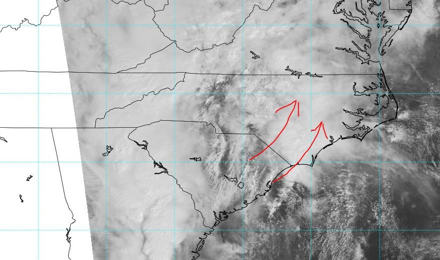
Yeah i was thinking the same thing till i saw the visible sat showing that clearing working its way north
-
1
-
-
6 minutes ago, kvegas-wx said:
Just remember, whoever starts a storm thread for this has to deal with the humiliation until December.
Was thinking about creating it lol!
-
Yeah it looks like WTVA has a nice live stream going with the storms tower cam and chaser video https://livestream.com/accounts/19464150/events/5405314/player?width=640&height=360&#=true&mute=true
-
1
-
-
Wow anyone else seeing snow/sleet I am in downtown winton and it's coming down
-
44 minutes ago, mackerel_sky said:
How’d these 2 amazing storms do for Gastonia?? I was there at the time, but 4-5 years old!
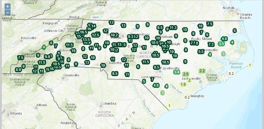
https://climate.ncsu.edu/climate/winter/event_details?e=96
-
1
-
-
Just now, olafminesaw said:
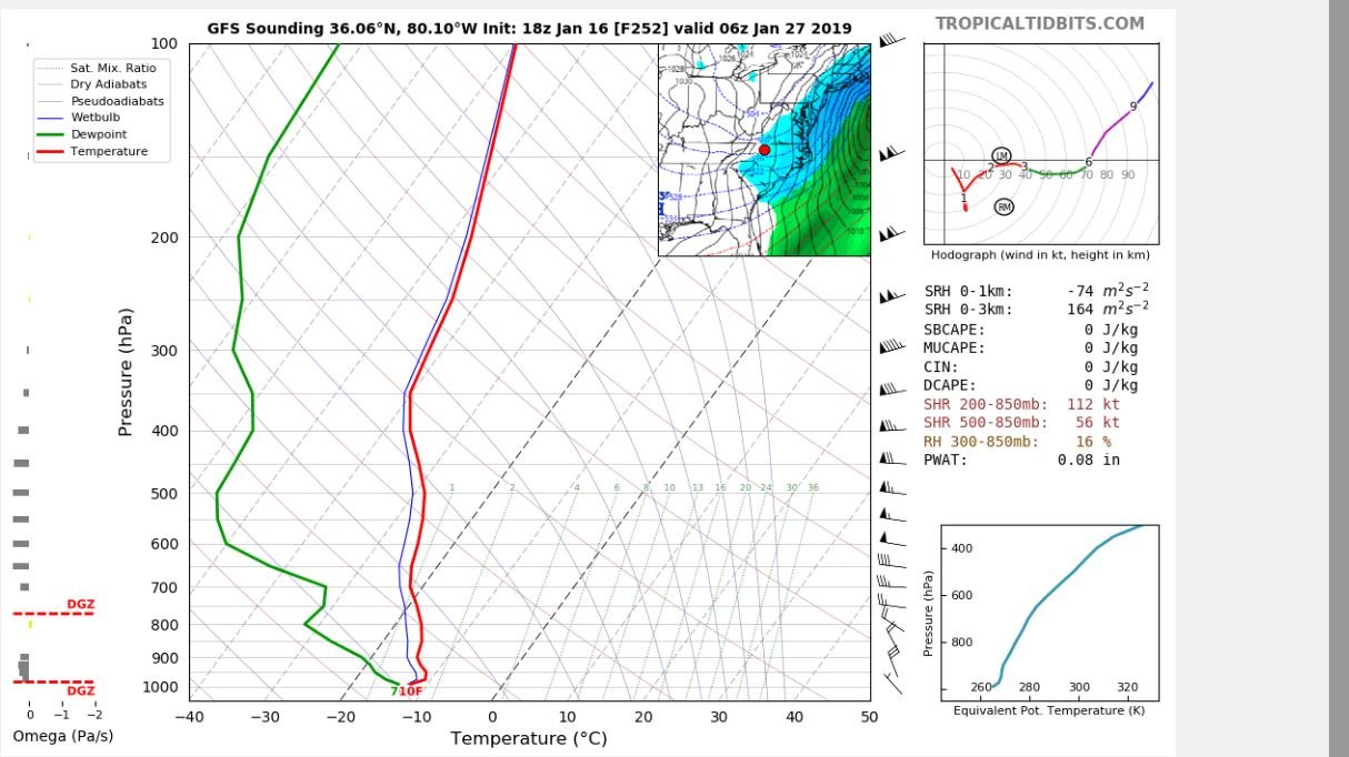
I don't understand how that can be snow, with that sounding, that's like, the opposite of saturated.
Good point 11 degrees with snow on the ground then
-
Whew not sure if that has happened in Greensboro before 10 degrees and snowing ! lol

-
1
-
-
So it looks like it's time to create a thread?
-
 1
1
-
-
8 hours ago, Poimen said:
Santa is bearing good gifts this year...even if they come after Christmas:
It looks like most of it is over Europe am I reading that right ? I hope I am wrong lol
-
Just now, olafminesaw said:
Warmer overall, but less of a warm nose this time, ends up evening out.

Was that a Gso sounding ?
-
I according to his Twitter he was sick. I hope you are getting well soon and back to making the winter videos[mention=390]msuwx[/mention] no idea what that means.,,lol. But Matt, why no videos since August?
Sent from my SM-N950U using Tapatalk
-
1 minute ago, sarcean said:
RAH is still almost refusing to acknowledge the possibility of significant snow
Wintry precipitation is still likely this weekend and confidence in
said occurrence is high, however the exact timing, amounts and p-
types are still uncertain due to continued model differences and
thus low confidence. Best chances for wintry precipitation are still
along and north of the US-1 corridor.

Overview: A pair of upper level lows/troughs will develop  on
Saturday, one off the Southern Rockies/Desert Southwest and the
other over the Northern High Plains/SW Canada. The former will shift
eastward then east-northeastward through the ARKLATEX and into the
TN Valley while the latter will dive south-southeastward, deepening
over the Plains/Midwest. The southern stream low will become
absorbed into the stronger northern stream low over the MS/TN Valley
Monday/Monday night as it continues its southward dive toward the
Gulf. Expect strong moisture advection into the Gulf Coast states
and Southeast US ahead of the system Saturday and Sunday. Cold, high
pressure will dominate at the surface over the Great Lakes region,
ridging into western/central NC through the period in a CAD setup.
Meanwhile, a surface low will develop along the Gulf Coast on
Saturday in response to the upper level system. The surface low is
expected to move along the Gulf Coast, through the panhandle of FL
and northeast along the Carolina coast, while the wedge remains in
place over northwestern portions of the area. As a result, there
will be a very strong pressure gradient from west to east across NC
on Sunday/Sunday night. Even the slightest shift in track, timing,
temperature, etc. will result in significant impacts to the
forecast.

Timing: The latest medium-range models suggest precipitation will
likely move into central NC very slowly from the south-southwest
late Saturday or Saturday night. The ECMWF continues to be a tad
slower than the GFS, though the timing has come into significantly
better agreement from 24 hours ago.

P-type: As mentioned above, a lot of uncertainty still remains with
respect to wintry precipitation, as any small change/difference in
timing, temperature, thermal profile, etc. will impact the p-type.
As past events would suggest, a purely snow event is not likely as
there is usually a mix of wintry p-types. Expect precipitation to
start as rain across the far south and southwest, though chances are
looking decent for a mix of rain/snow across the northwest half of
central NC when precipitation moves in overnight. A mix of p-types,
especially over the northwest half of central NC, is likely
overnight as temperatures fall, while the southeast could remain
rain for the duration. Expect several p-type changes throughout the
event, especially along and north of US-1, with snow, sleet and
freezing rain all possibilities. Regardless of p-type, liquid
equivalents could range from one to two inches. Will hold of on
getting too cute with any snow amounts at this time given the degree
of uncertainty and how the varying p-types would impact
accumulations.

Temperatures: Highs on Sunday expected to top out in the low to mid
40s while Sunday will be much colder in the NW, with highs topping
out around freezing while the SE should reach into mid 40s again.
Lows both Saturday and Sunday nights will be similar, upper 20s to
mid 30s Saturday night and low 30s to around 40 degrees Sunday
night. Monday highs in the upper 30s to mid 40s expected at this
time. -KC

Monday night through Wednesday: Medium range model guidance in
general agreement depicting a deep upper level low traversing the SE
U.S., initiating yet another deepening sfc wave just offshore of
SC/southern NC. The string dynamics associated with the upper level
low and the potential for the sfc wave to sling moisture back into
central NC. The models have trended a little farther south with the
system and attendant precipitation. Thus, expect a chance of rain or
rain/snow mixed primarily focused across the southern counties
Monday night. If the system drifts just a little farther north,
could see a threat for snow across the northern counties with some
light accumulation possible. Min temperatures generally in the 20s
to the lower 30s.

The upper level system and associated coastal low will sweep quickly
eastward and offshore Tuesday with improving weather conditions into
mid week. If there is any residual snow/ice pack across the
Piedmont, could see temperatures Tuesday night drop into the teens.
Away from the snow/ice pack, expect overnight lows in the 20s.
Afternoon highs will remain well below normal with high temperatures
in the 40s expected, closer to 50 across the far south-southeast by
mid week. -WSS
Yeah I hope they are wrong but normally when they are meh or have low confidence about a storm they are right quite a bit. I hope that changes today !
-
2
-
Mid to Long Term Discussion 2021
in Southeastern States
Posted
Stupid question maybe but why is there a gap between the rain and snow ?