

Hitman
-
Posts
2,878 -
Joined
-
Last visited
Content Type
Profiles
Blogs
Forums
American Weather
Media Demo
Store
Gallery
Posts posted by Hitman
-
-
100 on the nose
DP down to 72
-
 1
1
-
-
-
84/76 here
-
When I got home around 5 yesterday the dew point was 84. House is situated in a bowl with a lake at the bottom and the stream feeding it. Its always muggy
-
I'm at the office but my station at home is reading 95f with an HI of 121
That's hot!
-
 1
1
-
-
I'm no rocket scientist but i knew it was bad yesterday when I walked out the door and my glasses immediately fogged up. Dp got up to 81 yesterday.
-
1
-
-
17 minutes ago, crossbowftw3 said:
This is beginning to look like serious big league heat now. Maybe on one hand I can count days that ever got as hot as Monday/Tuesday are now forecasted to be.
Bring it!
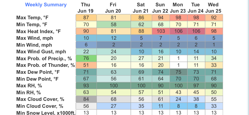
honestly, the dp is 75 here now, how much worse can it be?
-
dogs living with cats, real biblical stuff. meanwhile, I thought it was supposed to be rainy all day. just hit 90f by my office in the bronx.
-
 2
2
-
-
.1” here
-
.09”. Good for the grass.
-
I got a warned cell that turned into a grand total of .02”
-
.7” today and 6.07” for the month. Plenty, thank you. Ready for some warm dry weather.
-
1
-
-
Another half inch since midnight. Approaching 5” for the month.
-
and we're finally officially out of drought. Now listed as "abnormally dry" which is still ridiculous but less egregious.
-
1
-
-
Lingering misery mist. .82” today. 3.4” for the month. Good for the ducks and the grass seed I put down on Sunday.
-
56 minutes ago, IrishRob17 said:
Rapidly approaching 3" here since last weekend.
I’m at 2.66”
-
1
-
-
.55” here
-
time for me to get in on the fun
Special Weather Statement National Weather Service New York NY 358 PM EDT Thu May 8 2025 NYZ067>070-082030- Putnam NY-Rockland NY-Northern Westchester NY-Orange NY- 358 PM EDT Thu May 8 2025 ...A STRONG THUNDERSTORM WILL IMPACT NORTHERN WESTCHESTER... SOUTHEASTERN ORANGE...WESTERN PUTNAM AND ROCKLAND COUNTIES THROUGH 430 PM EDT... At 357 PM EDT, Doppler radar was tracking a strong thunderstorm over Pomona, or near New City, moving northeast at 10 mph. HAZARD...Wind gusts up to 40 mph and pea size hail. SOURCE...Radar indicated. IMPACT...Gusty winds could knock down tree limbs and blow around unsecured objects. Locations impacted include... New City, Peekskill, Monsey, Haverstraw, Suffern, West Point, Sloatsburg, Cold Spring, Pomona, Yorktown Heights, Spring Valley, Stony Point, Jefferson Valley, Putnam Valley, and West Haverstraw. -
Still in D1 even after the 2"+ of precipitation from the latest system. Supposedly due to low stream flow and ground moisture. Not the case in my area. There is a stream (Furnace Brook) that runs through my property and it is anything but low. More like roaring or raging.
-
2
-
-
1.99” here
-
1
-
-
Half inch on the nose here.
-
Still some sleet mixed in with the rain. Up to 35f. What a miserable date. #springsucks
-
1
-
-
34f with a scattered covering of sleet. Lovely.
-
1
-
-
and we're still in D1. My eyes tell me otherwise with more rain incoming.
-
2
-
Interior NW & NE Burbs 2025
in New York City Metro
Posted
101 woohoo