

NJHurricane
-
Posts
2,143 -
Joined
-
Last visited
Content Type
Profiles
Blogs
Forums
American Weather
Media Demo
Store
Gallery
Posts posted by NJHurricane
-
-
47 minutes ago, WinterWxLuvr said:
Thanks for the update.
For more uplifting news, I’m scheduled for a rectal tomorrow morning.
How much for Philly?
-
 5
5
-
-
Seems like a solid northerly component to our wind so far….probably 0.2” in National Park NJ across from PHL
-
1 minute ago, Brian5671 said:
for a rainstorm? Lol
If an inversion doesn’t kill it….could be a period of 50mph+ in much of the state.
-
-
59 minutes ago, Rockem_sockem_connection said:
I am fairly comfortable calling this a non-event for people east of PHL. A couple of shifts could result in mixed precip but I am comfortable making the call now. It will be more interesting N&W but it is looking to be a slop fest at this point. I find this stuff so intriguing though. I am so invested in places like GA and SC getting snow because it's less common and at a high level, it almost sounds unbelievable that it could snow in GA and rain in NJ. It's truly amazing stuff and I am OK not having to stare at snow pack for 3 weeks. I'll for sure be checking in on this one but it looks like a fascinating southern special - the weather channel will definitely be on my TV all day that day.
Blessings all!
-RSC
From an accumulating snow perspective I agree. Think wind potential is serious and depending on the details of our likely coastal plain track can’t rule out thunder or locally heavy rain though….but if snow is someone’s entire game at and around PHL I’d definitely hit the expectations reset button once the 12z suite is in.
-
29 minutes ago, Doorman said:
the mid-atlantic forum has 100+ members online at 4:00 pm
for a storm 6 days out......MLK day
Roger Smith from Canada is trolling us and them with 2ft totals
all from the shell game of computer guidance
I smell a bust
just saying


-
On 1/7/2022 at 4:46 PM, LVwxHistorian said:
Actually, I'm getting a masters in ATMO right now!! And want to be a forecaster, so I'm telling you what I would have said, and what every good forecaster should say, instead of painting yourself into a corner. And they make very good $$, 70 to 100k
Their forecasts are very important, for commerce, people in general. People lost their lives directly because of this botched forecast!!! What are you talking about?!!
Son….trolling doesn’t pay much.
Earn literally dozens of $$$ using this one simple trick. Real meteorologists will h8te u!!!
-
On 1/7/2022 at 4:38 PM, LVwxHistorian said:
I'm not, I'm just questioning what we're paying these people a lot of money to do -- get extremely important forecasts completely wrong??!!!!
Obvious troll is obvious
-
 2
2
-
-
5 hours ago, LVwxHistorian said:
Wow what's the hostility for?! I'm just trying to engender a spirited debate, there's no need for personal attacks, obviously none of you were debaters in high school! And I haven't called anyone a name.
I've already explained why I posted this: to understand why someone would make such a confident forecast with such a powerful storm so close, since I plan to be in that position one day.
Gosh, what sensitive weenies you all are!!
PS If you got a problem, report my posts -- I did yours!
I’ve reported your troll ass….. I’ve been here much longer than you. You’re beyond worthless.
-
1
-
 2
2
-
-
-
10 minutes ago, hurricane1091 said:
The streets and sidewalk have totally dried here in Gloucester County. The schools are closed though lol. Weatherman will have some explaining to do at 5 tonight
")
Literally every reputable forecast source emphasized the fringey uncertainty of even a barely plowable snow. I’d have loved some accumulation but nobody should be angrily surprised.
-
3
-
-
First flakes in National Park, far NW Gloucester county NJ started at 4:47am
-
Solid discussion from Mt Holly…below is the majority of the near term portion.
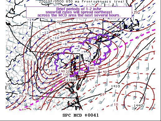
The main change to the forecast overnight was an increase in QPF, and by association, snowfall, for areas previously within and that were just north of the previous Winter Storm Warning. The QPF increase is almost unanimously supported by the last two cycles of global and hi res guidance, and translates to an increase in snow totals. The most difficult portion of the forecast remains the northward extent of precipitation shield. Even many of the recent model runs which increased QPF across the south generally didn`t move the precipitation shield north much. The latest blend does bring amounts up somewhat in the I-95 corridor. However, there is likely to be an exceptionally sharp northern cutoff to accumulating snow, probably even sharper than the latest forecast, which as it is has a much sharper than normal gradient. Even across, for example, Philadelphia County, it would not be surprising to see a significant difference in totals. And for northern portions of the area, it will simply be a cloudy and cold day with perhaps some flurries. Confidence in snowfall is much greater for southern areas. It is clear now that a swath of heavy precipitation will overspread the region. Extreme frontogenetic forcing is allowing precipitation to expand in coverage and intensity to our southwest, and this will only continue today. While precipitation is beginning as rain in some places, temperatures are continuing to cool behind yesterday`s front, and a flip to snow will occur. One possible exception is far southeast Delaware, where rain or mix could hold on for longer. Amounts were reduced a bit there. Otherwise, a large stripe of 8 to 12 inches of snow is now forecast, and can`t rule out some localized amounts a little over 12 inches. Snowfall to our southwest has generally been over-performing, and this trend could continue into our area. Snowfall rates could easily exceed 1 inch per hour at times this morning, perhaps 2 inches per hour. While snow ratios overall will be less than 10:1, these rates will quickly overwhelm the warm ground conditions left by recent near record warmth. These snowfall rates could persist for several hours this morning and early afternoon. Banding features are certainly possible within the heavy snow shield, leading to some local variations. Eventually, precipitation will end from west to east late this afternoon and this evening as the area of low pressure moves out to sea.-
1
-
1
-
-
FWIW…NWS upgrade of Salem/Gloucester/ Camden counties in NJ about an hour before the usual zone forecast update. Guessing eastern parts of these counties look more solid to hit the 4 inch low end warning threshold
-
Just now, turtlehurricane said:
I'd say there's a 90% chance we're gonna have an major oil spill, from this and all the other oil facilities/rigs getting obliterated.
Don’t they cap/secure them prior to the storm…not the rig so much as the well itself.
-
5
-
-
11 minutes ago, Will - Rutgers said:
if it makes you feel any better, the success of this camera guarantees someone will do this again for the next Cat4/5. probably put it up a bit higher on the pole. that thing was going to last all day if the ocean didn't get to it.
Pelican cases ftw
-
2
-
1
-
-
Staying at the Hard Rock in AC and watching these tornado warnings creeping up the Delmarva. Should be an interesting couple of hours, had the sideways wind driven rains with sheets of water against our 19th floor windows an hour ago. Starting to crank again now. I know they’ve seen much worse here from hurricane passbys and Nor’easters but taking it all in with enthusiasm as personal business justhappened to bring us down here just in time for Elsa.
-
Eyeball probably passing 3 here, and still hanging on to snow...National Park NJ across from PHL. Noticing some very light returns filling in a bit west of me too, wondering if we can add a little back end pixie dust into the morning.
-
1
-
-
Very light snow commenced at 11:22pm in National Park NJ, across from PHL.
-
12 hours ago, The Iceman said:
Tt maps but I'm sure this includes some of the changeover. Would be very nasty! 3-6" thump then .025"-.5" of ice. Cmc also has a small event on Tuesday for the northern half of the forum. This week should be fun, I see 3 threats this week where we have a decent shot at snow, then we still have your storm lurking in the distance next week. Plus none of the models really show the pattern breaking down any time soon.

See a lot of people referencing 1994 on the ice. Normally I chuckle when I see 1994 mentions, the past few days though...can’t say I’m laughing.
-
Persistent sleet here in National Park NJ...I suspect same at PHL.
Good luck to all who flipped back to snow, hope you reach your projections.
-
31 minutes ago, Newman said:
Turning back to all snow here!
Good to hear.
Location reminders super appreciated for those of us on old mobile devices ty
-
2
-
-
52 minutes ago, zenmsav6810 said:
Seems like its running a bit behind the others but I cant be certain
We will know by late morning if it’s huffing glue.
Would not be the first time that the once undisputed King of the medium range laid an egg while a long duration event. Wish I was rested enough to recall specific examples.
-
National Park NJ, 1 mile from PHL
Light sleet/zr mix started about 15 minutes ago as I shoveled.

January Banter 2022
in Mid Atlantic
Posted
If this suite produces a miracle you’ve set a precedent….wine and taxes to save every threat. Need to crack open a vintage closed 500h.