LVblizzard
-
Posts
4,968 -
Joined
-
Last visited
Content Type
Profiles
Blogs
Forums
American Weather
Media Demo
Store
Gallery
Everything posted by LVblizzard
-
The NAM never gets rates above 1”/hr into our area but the sheer duration of the storm makes up for it. When you see nearly 2 days straight of moderate snow it’s going to pile up.
-
I wouldn’t call this NAM run a “huge win.” It still gets mixing up to the Lehigh Valley. It’s not a total disaster like 6z but it’s still not great.
-
From 0z? Maybe. From 6z? Probably not.
-
I’d be lying if I said the NAM didn’t have me a little on edge. It’s been the first to sniff out big northwest trends in the past. Of course there’s a lot of times when it’s off its rocker too, but you just can’t completely toss it right now.
-
1. Clean up the drinks you spit all over your screen 2.. UKMET and Euro
-
Lancaster County special on the CMC...nearly 4 feet in the jackpot area! If I lived in that exact location I'd print out the snow map and frame it on my wall.
-
Some of these models have periods of light snow all day on Tuesday and that would just be amazing after getting a foot or more of snow. Love the mood flakes after a big event.
-
Philly weenies are gonna faint when they see the RGEM...
-
That’s over 36 hours straight of snow. Super long-duration storm is back on the menu!
-
I just posted 4-8” for the Lehigh Valley on my page but I stressed that confidence is low.
-
NAM looks like it’s a tick south.
-
The Euro run definitely eased some of my anxiety. It doesn’t look like a total whiff is a realistic solution here in the Lehigh Valley. Now the question is, is this a run of the mill 3-6” storm or will it be much more significant?
-
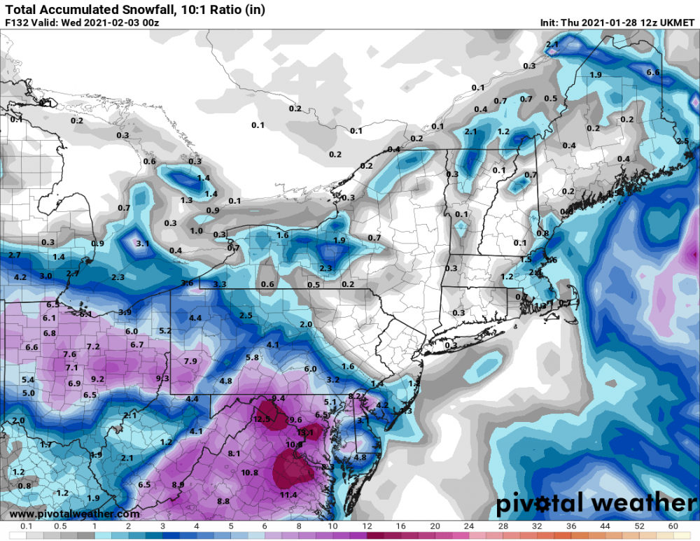
UKMET crushes most of the area. Very sharp cutoff north of the Lehigh Valley though. Allentown sees close to a foot while Jim Thorpe and Hazleton only get an inch or so.
-
Seems like we’re near the cutoff with so many storms. It only takes a small change for us to go from 12-18” to 2-4” here with this one.
-
Remember, the Euro was the southern outlier with the Jan. 2016 storm too. I remember it came close to whiffing Philly for a few runs.
-
Happens on the RGEM too which has a very similar look to the NAM at the end of its run.
-
NAM looks very good. Would probably be a decent hit for most of us if extrapolated.
-
The trend within 3 days this winter has been to weaken the confluence, resulting in a more north storm. Even if 0z models keep going south this is far from over.
-
I wonder if there’s a chance that phases in?
-
Euro ensembles are getting a little iffy for northern areas. Really hope that trend stops.
-
Model consensus is very, very good if you take away the UKMET.
-
The UKMET is the nightmare scenario.
-
There’s a clear trend south from tonight to this afternoon with the location of the coastal low. Reminds me of tracking the Jan. 2016 storm. One more shift south and I might start to get a little worried here in the Lehigh Valley.
-
Euro torches the turnpike for like 6 hours, that’s why totals are lower there. Still a great run.
-
Really liking where I'm at in the Lehigh Valley...even the warmer solutions with some mixing still give us 6-10" here. Gonna be nice to enjoy a long-duration storm all the way from Sunday to Tuesday.