

metalicwx366
-
Posts
7,071 -
Joined
-
Last visited
Content Type
Profiles
Blogs
Forums
American Weather
Media Demo
Store
Gallery
Posts posted by metalicwx366
-
-
There we go.
864
WFUS52 KTAE 230009
TORTAE
GAC017-155-230045-
/O.NEW.KTAE.TO.W.0021.180723T0009Z-180723T0045Z/
BULLETIN - EAS ACTIVATION REQUESTED
Tornado Warning
National Weather Service Tallahassee FL
809 PM EDT SUN JUL 22 2018
The National Weather Service in Tallahassee has issued a
* Tornado Warning for...
Southeastern Irwin County in south central Georgia...
South central Ben Hill County in south central Georgia...
* Until 845 PM EDT.
* At 809 PM EDT, a severe thunderstorm capable of producing a tornado
was located over Ocilla, moving east at 25 mph.
HAZARD...Tornado.
SOURCE...Radar indicated rotation.
-
Looks like a tornado warning may be needed for that storm near Fitzgerald, GA. Decent rotation with that storm.
-
Lots of strong to severe storms training across NE Florida today. Looks like 4-7 inches of rain have fallen near the Gainesville area.
Currently under a severe thunderstorm watch here until 8pm. Still no convection in SE GA with that forcefield going strong. Even areas outside of the severe thunderstorm watch and outside of the marginal risk area to the north are getting strong to severe storms.
-
8 hours ago, Brick Tamland said:
Not looking forward to a whole week of rain. Talk about spoiling summer.
Back in Waycross for vacation. We’ve had storms every day since I’ve arrived on July 12th.
-
 3
3
-
-
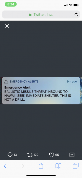
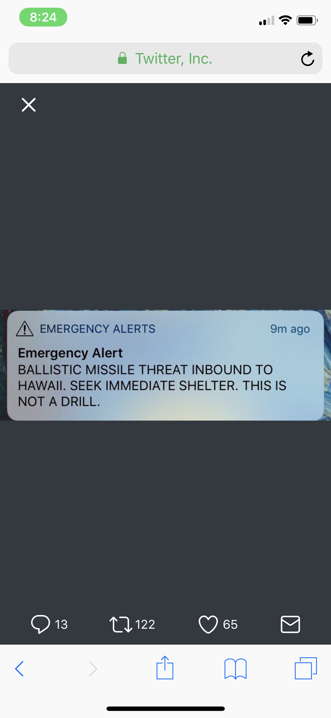
That was terrifying. Someone ****ed up big time. Nothing like waking up to a incoming ballistic missile alert with sirens going off everywhere. This is the alert everyone in Hawaii received.
-
1
-
 1
1
-
-
9 minutes ago, mackerel_sky said:
As long as your still not there, your probably right!

Haha so true. I can fly over to the big island of Hawaii and see snow. There was a winter storm warning up there a few days ago for like 2-4 inches of snow.

-
28 minutes ago, mackerel_sky said:
No! But if yes, that'll be a lot of 35 and rain
You aren’t getting snow. This storm has Waycross written all over it.
-
 1
1
-
-
LOL Jon. Autocorrect for the win. Wondering if anyone else caught that in the storm thread.

-
10 hours ago, Jon said:
He's on another board. I also just registered and am posting on that board.People were way too fast to run away webber on this board, lots of insight and he's going to be one of the most recognized distinguished mets of his time - that's a fact. I can't imagine where he will end up in 20 years...probably some climate forecaster with a million twitter followers. Ha.
What board and what's his Twitter name?
-
Sigh, these Carolina folks.We cannot read the space in your mind.

-
Do you not see the space between thisyou really are stupid.
 and what I posted? I was talking about the link Disc posted. I wasn't calling you Disc.
-
Pickup lines: http://www.weather.funnelfiasco.com/pickup_lines.html
:lmao: Thanks Disc. Been looking for that one for a while!
-
Lol chill out.
-

I hate when it comes out small.
2018 Banter Thread
in Southeastern States
Posted
Returning back to the island in a week. I forgot how much getting shafted by TSTMS pissed me off.