

nchighcountrywx
-
Posts
2,602 -
Joined
-
Last visited
Content Type
Profiles
Blogs
Forums
American Weather
Media Demo
Store
Gallery
Posts posted by nchighcountrywx
-
-
Mike Dross (@MikeWDross)
@AlConklin Yep. It gets started /w deterministic snowfall maps from GFS/ECMWF that are flawed to begin with, not to mention 5+ days out. By the time we get into the mesoscale model time frame (when we actually know what's likely), public already going off flawed/inferior/old model data.
+100
-
 1
1
-
 1
1
-
-
Cutting totals way back
-
 2
2
-
 1
1
-
-
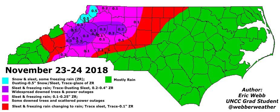
NWS has lots of key decisions today.
I would not be surprised to see this migrate over into primarily a sleet event outside of the mountains into the western piedmont.
-
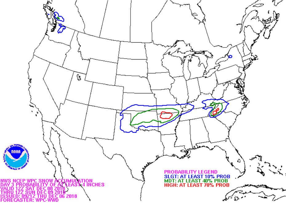
WPC Discussion
https://www.wpc.ncep.noaa.gov/discussions/hpcdiscussions.php?disc=qpfhsd
...Southern Appalachians... Day 3... Developing low pressure along the Gulf Coast will strengthen and push eastward to be near the GA/SC coast at the end of day 3. This low will develop in response to a southern stream shortwave moving through the Arklatex and into the TN Valley, as well as diffluence within the right entrance region to an upper jet streaking across New England. Guidance is in reasonably good agreement in the evolution and placement of this surface low, with the NAM a strong and very cold outlier, while the CMC is too fast with the phasing of northern stream energy, and is pulling the surface low too far north too quickly. A blend of the GEFS and ECEns mean is preferred, which suggests precipitation spreading across the Southeast during Saturday. The guidance has overall slowed precip onset due to dry air within a strong wedge of high pressure which remains in place as a result of robust mid-level confluence. E/SE low and mid-level winds spread northward atop the surface wedge, isentropic lift will increase, and precipitation will gradually saturate the column. This will result in wet-bulb cooling of the thermal profile and snow/sleet/freezing rain is all likely to develop Saturday night, with snow in the higher terrain and freezing rain/sleet elsewhere. Despite model differences in timing and p-type, there is a strong multi-model signal for more than 4 inches of snow in the Southern Appalachians before 12Z/Sunday and this is where WPC probabilities are highest for accumulating snow. Some uncertainty exists into how far north precipitation will spread on Day 3 due to dry air inhibition, and there is likely to be a sharp north gradient to snowfall. Additionally, a period of freezing rain and sleet is likely in portions of the mountains and foothills, and WPC probabilities have increased to 20 percent for 0.25 inches of accretion across portions of the area.
-
1
-
-
Glanced at 6z GFS Buffkit
Hickory snow is way down from 20"+ yesterday to 6" today
Winston is at 13"
RDU at 0
CLT at 4
http://www.meteor.iastate.edu/~ckarsten/cobb/cobb.php?model=namm&site=khky
-
1
-
-
Watch your Buffkit data....
The lines are already being drawn.
As of the morning runs:
GSO, INT, HKY snow.
All other sites to the South and East.. no snow (RDU, CLT) with transition line somewhere in between those areas.
-
1
-
-
2 hours ago, Jonathan said:
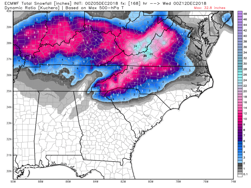
More realistic. Cut those Kutcher’s totals about in half and you will be close to what the NWS eventual accumulation forecasts will be
-
1
-
-
GSP AFD
Emphasis on 40knot SE Winds at 850mb providing moisture transport and warm nose.
LONG TERM /FRIDAY NIGHT THROUGH TUESDAY/ AS OF 350 AM WEDNESDAY: ABOVE NORMAL CONFIDENCE EXISTS FOR A SIGNIFICANT WINTER STORM ACROSS AT LEAST PORTIONS OF THE FORECAST AREA THIS WEEKEND AND POSSIBLY LINGERING INTO EARLY NEXT WEEK. THIS IS DUE TO UNUSUALLY GOOD CONSISTENCY BETWEEN MODELS AND FROM RUN TO RUN REALLY FOR SEVERAL DAYS NOW DESPITE THE STORM SYSTEM NOW PUSHING INTO THE SOUTHWEST U.S. THIS HAS OCCURRED IN THE PAST, ESPECIALLY FOR UNUSUALLY SIGNIFICANT STORMS. THIS STORM MAY FALL IN THE UNUSUAL SIGNIFICANT CATEGORY, ESPECIALLY ACROSS THE MOUNTAINS AND FOOTHILLS AS IT SEEMS TO HAVE ALL THE NECESSARY INGREDIENTS FOR A HIGH IMPACT WINTER STORM. THIS BEING SAID, BELOW AVERAGE CONFIDENCE CONTINUES IN THE EXACT FORECAST DETAILS AND RELATED POTENTIAL IMPACTS AS RELATIVELY MINOR SHIFTS TO THE STORM TRACK OR STRENGTH CAN LEAD TO SIGNIFICANT CHANGES WHERE AND HOW LONG WINTRY PRECIP SETS UP. HIGH PRESSURE WILL CONTINUE TO NOSE INTO THE MID-ATLANTIC STATES FRIDAY NIGHT BEHIND THE COLD FRONT BEFORE WEDGING DOWN EAST OF THE MOUNTAINS DURING THE DAY SATURDAY, SUPPORTING COLDER AND DRIER LOW LEVELS, AHEAD OF THIS WEEKENDS STORM SYSTEM. THE STORM IS EXPECTED TO SLIDE ALONG THE GULF OF MEXICO COASTLINE FRIDAY INTO SATURDAY BEFORE TURNING THE CORNER NEAR THE SOUTHEAST U.S. COASTLINE BY LATE IN THE DAY SUNDAY. INCREASING MID TO HIGH LEVEL CLOUDS LATE FRIDAY NIGHT INTO SATURDAY WILL LIKELY ASSIST THE CAD IN LOCKING IN COLD TEMPERATURES WITH HIGHS ONLY IN THE 30S TO AROUND 40 OR 15-20 DEGREES BELOW NORMAL. INCREASING MOIST SOUTHERLY FLOW ENHANCED BY ISENTROPIC LIFT UP AND OVER THE ESTABLISHED COLD DOME AT THE SURFACE WILL SUPPORT INCREASING PRECIP CHANGES FROM THE SOUTHWEST THROUGH THE DAY. SATURDAY NIGHT INTO SUNDAY MAY BE THE MOST SIGNIFICANT PRECIPITATION OF THE STORM AS STRONG SOUTHEASTERLY 30 TO 40 KT 850 MB WINDS ORIGINATING FROM THE GULF OF MEXICO ENHANCE MOISTURE TRANSPORT. THIS FLOW IS ALSO PERPENDICULAR TO THE COLD DOME CONTINUE TO BE SUPPORTED BY A 1030+ MB HIGH TO THE NORTH AS WELL AS THE PERPENDICULAR TO THE MOUNTAINS WHICH WILL ENHANCE LIFT AND THEREFORE PRECIPITATION INTENSITY AND TOTALS ACROSS THE REGION. PRECIPITATION TYPES ACROSS THE REGION IS THE MOST CHALLENGING ASPECT OF THIS STORM AS IT APPEARS AREAS ALONG AND NORTHWEST OF I-85 WILL LIKELY SEE AT LEAST SOME WINTRY PRECIP TO THE MOUNTAINS WHICH MAY EXPERIENCE MOSTLY SNOW AND ICE. WARMER AIR ALOFT (WARM NOSE) MAY TRY TO WORK INTO THE REGION WITH THE HEAVIEST PRECIPITATION SUNDAY INTO SUNDAY EVENING LEADING TO GREATER ICE/RAIN POTENTIAL AT LEAST BRIEFLY ACROSS THE REGION. THE DURATION OF PRECIPITATION TYPES WILL BE CRITICAL AS CURRENT LIQUID PRECIPITATION CONTINUES TO FALL IN THE 1- 2 INCH RANGE WITH UPLOPE AREAS POSSIBLY SEEING UP TO 3 INCHES. THE TAKE HOME MESSAGE IS THAT WERE ARE POTENTIALLY DEALING WITH A DANGEROUS STORM WITH SIGNIFICANT SNOW AND ICE ACCUMULATION NOW LIKELY ACROSS THE MOUNTAINS AND FOOTHILLS AND POSSIBLE ANYWHERE ALONG AND NORTHWEST OF I-85. EARLY ESTIMATES PLACE A POTENTIAL FOR SNOWFALL AMOUNTS IN EXCESS OF 6 INCHES ACROSS THE MOUNTAINS AND NC FOOTHILLS WITH ICE ACCUMULATIONS POSSIBLY IN EXCESS OF 1/2 OF AN INCH ACROSS NC FOOTHILLS/PIEDMONT, ESPECIALLY NORTH OF I-40. NOW IS THE TIME TO PUT YOUR WINTER WEATHER PLAN TOGETHER AND PREPARE FOR THIS POTENTIALLY SIGNIFICANT UPCOMING WINTER STORM. THE LOW IS EXPECTED TO INTENSIFY FAIRLY RAPIDLY OFF AND SLOW DOWN OR STALL OFF THE NC/VA COAST MONDAY GUIDANCE CONTINUES TO SHOW A REINFORCING SHORT WAVE DIVING INTO THE TROUGH. THIS MAY SUPPORT ENHANCEMENT OF PRECIPITATION ON THE BACKSIDE OF THE STORM EARLY NEXT WEEK, LEADING TO POTENTIALLY ADDITIONAL WINTRY PRECIP ACROSS THE REGION.
-
2
-
-
-
-
It is a shame certain Mets totally discounted the stellar HRRR
Many companies then put their employees in extreme danger yesterday and many came home to damage that could have been contained if they were home
-
Zirconia NC Mesowest DW1971
10:46am
NNW at 21 with Gusts to 54
(corrected NC)
-
-
Greg Carbin (@GCarbin)
Over the next 36-hours or so, areas of the North Carolina Piedmont and the mountainous terrain of western NC will experience devastating flash flooding unlike anything in recent memory. Roads and bridges will wash away and damage will be severe. #PDS_Flash_Flood_Watch
William N Harrell Jr
-
Greg Carbin (@GCarbin)
Over the next 36-hours or so, areas of the North Carolina Piedmont and the mountainous terrain of western NC will experience devastating flash flooding unlike anything in recent memory. Roads and bridges will wash away and damage will be severe. #PDS_Flash_Flood_Watch

-
1
-
-
Any information on surge in Topsail Beach?
-
42 minutes ago, the ghost of leroy said:
that's why i love that new GOES 17 viewer. throw on the cirrus band and you can see through the emperor's new clothes in a way that traditional visible channels obscure.

Is there a public link to the Goes 17 Image Viewer that you are showing us? Thank you.
-
1
-
-
-
1
-
-
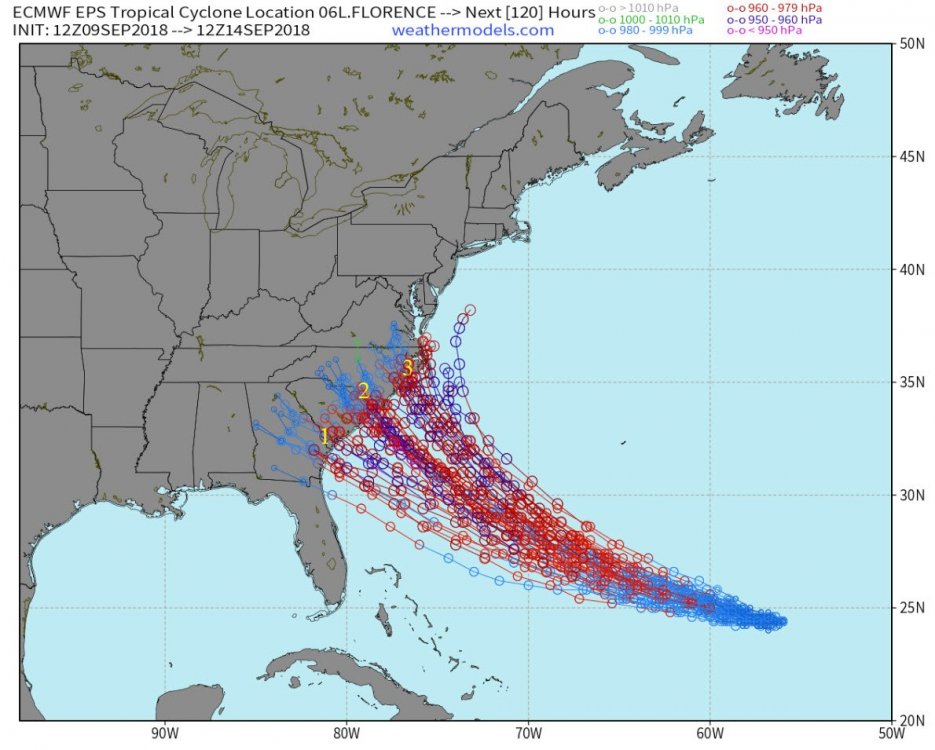
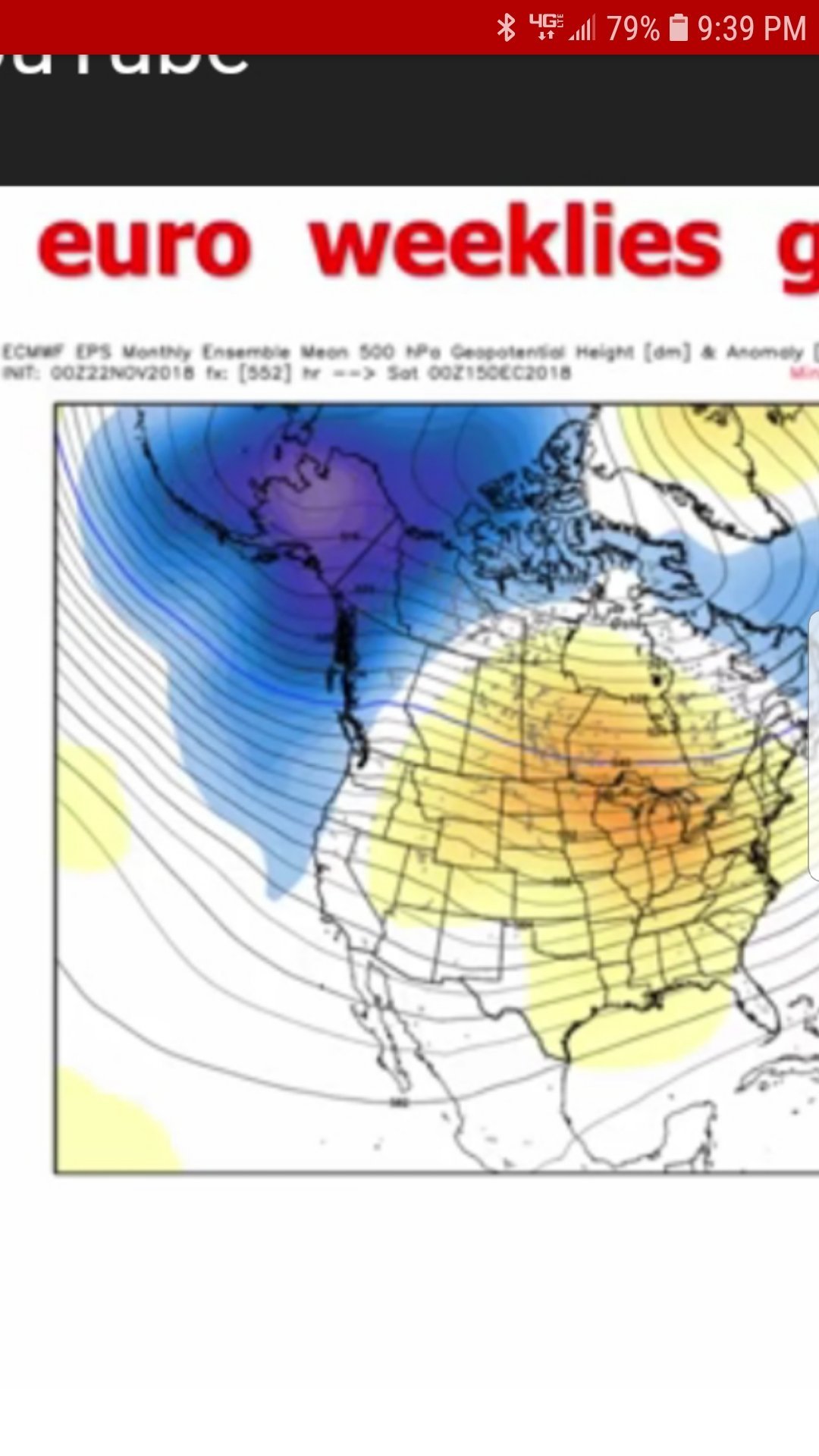
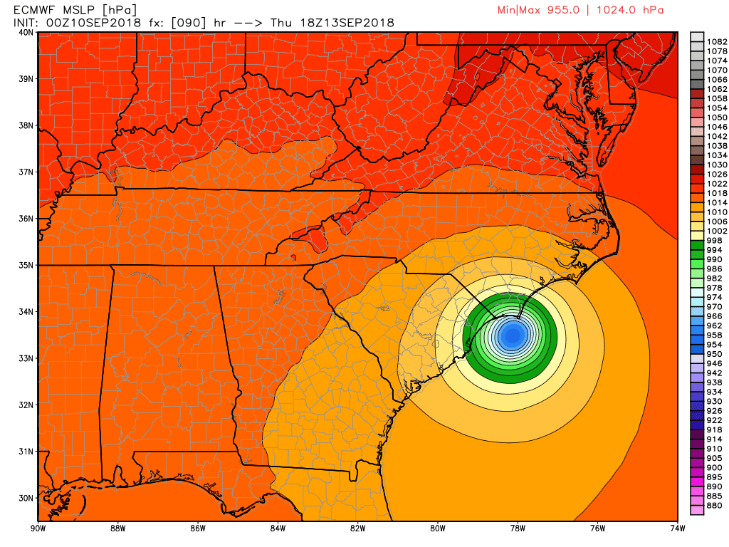
Hurricane Florence Afternoon ECMWF Package Sunday 09SEP18
Key Points
- Forward speed increased due to stronger ridge bringing Florence onshore just south of Wilmington NC around 1pm Thursday instead of 1AM Friday.
- ECMWF take Florence further inland to Surry County and then rains out over NW NC and SW VA for 3 days.
- Updated ECMWF Ensembles are forthcoming
PDF File at this link:
Hurricane Florence Afternoon ECMWF Package Sunday 09SEP18
-
2
-
37 minutes ago, downeastnc said:
This is really old.....this has the storm as 110 mph and at like 48W.....she is at 56W west.....I would put the chances at this thing being off Cape Canaveral that close to Florida at extremely low with zero model support.....
Thanks. I should have looked closer at the location and times. I will remove it for clarity
-
2 minutes ago, SnoJoe said:
We were scheduled to move back on the weekend of the 22nd. Not sure what we're going to do now. We haven't been to NYC in a while so I booked a flight and a room for a week on Wed. Guess we'll come back to whatever is left and pack up then. I'm not staying on this island for this one if it comes through here.
Joe:
Good luck and I hope the storm leaves you with minimal damage on Emerald Isle. I agree this one would not be on to stay around and mess with.
-
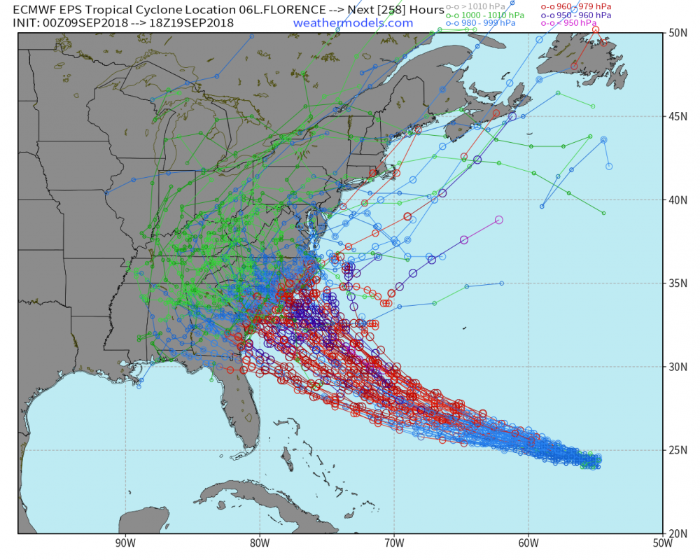
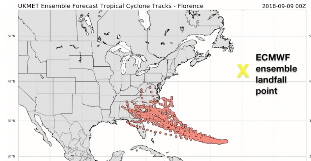
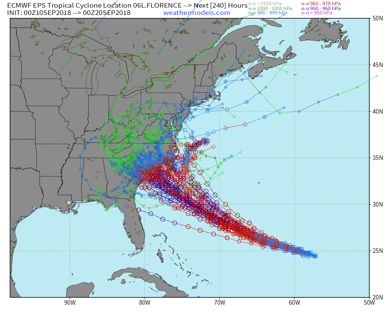
Ensembles shifted overnight with some back into SC which could bring the storm in underneath us with more impacts in Western NC
Sure bears watching
-
Complete Sunday Morning Florence Package available.
PDF File of Sunday Morning Package
Key Points:
- After high altitude sampling of the offshore environment ahead and north of the storm yesterday, the ridge to the NE and N of Florence is now trended to be stronger
- Ensembles have shifted SW with some members back into South Carolina
Sunday 09SEP18 7AM Florence Package
Depend on your local NWS office for official information in making all preparation decisions
-
1
-
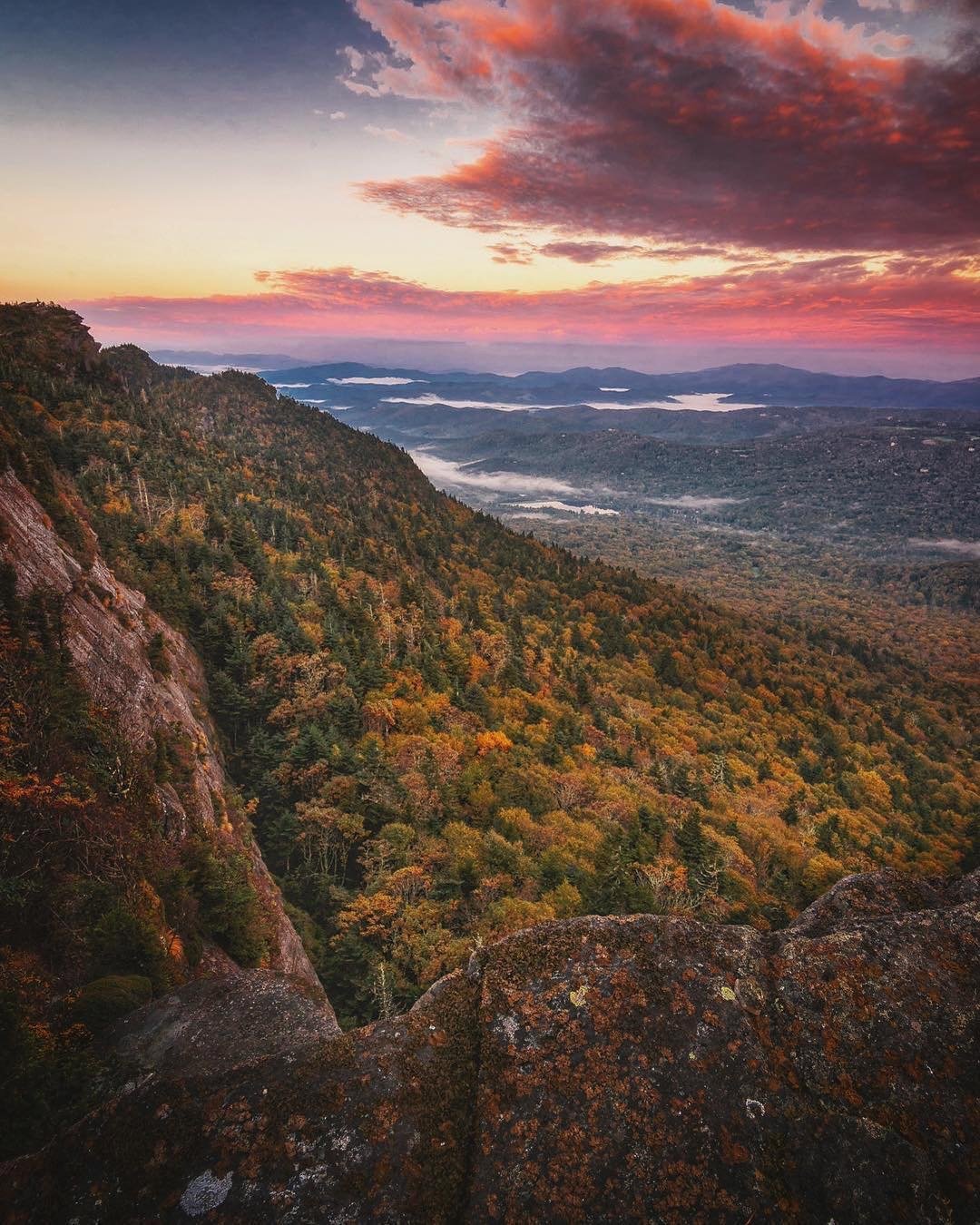
To help get us into autumn here are 2 superb drone videos from the High Country
Roan Mountain
Grandfather Mountain


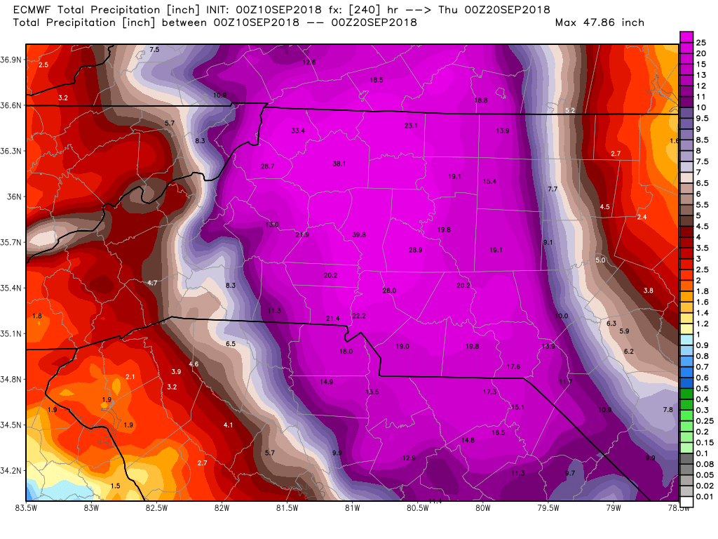


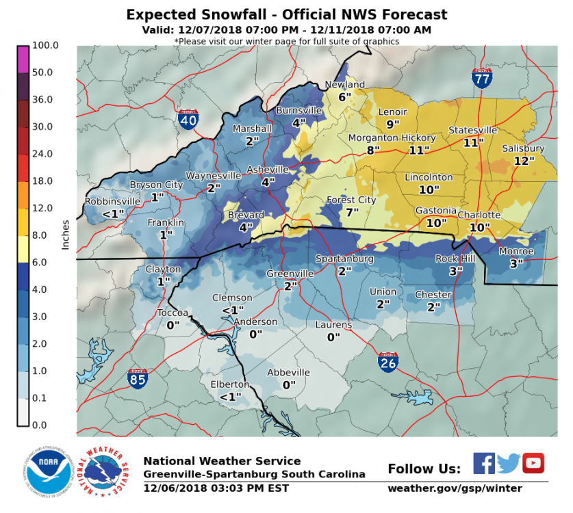
December 8-10, 2018 Winter Storm
in Southeastern States
Posted
WPC Heavy Snowfall Discussion
https://www.wpc.ncep.noaa.gov/discussions/hpcdiscussions.php?disc=qpfhsd