

nchighcountrywx
-
Posts
2,602 -
Joined
-
Last visited
Content Type
Profiles
Blogs
Forums
American Weather
Media Demo
Store
Gallery
Posts posted by nchighcountrywx
-
-
-
It’s here
-
 5
5
-
-
-
-
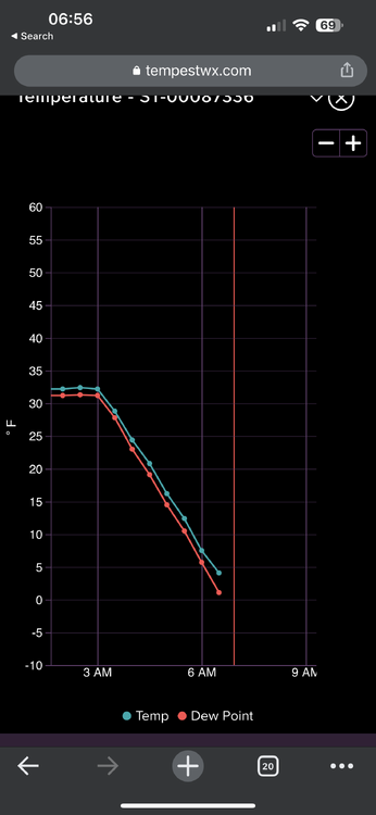
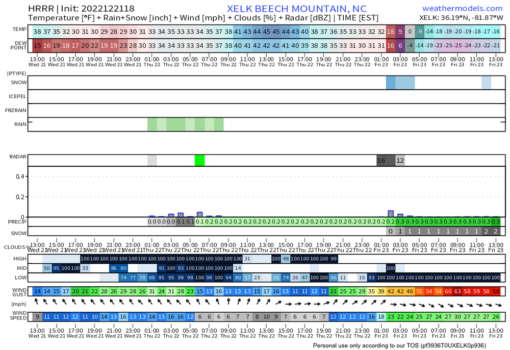
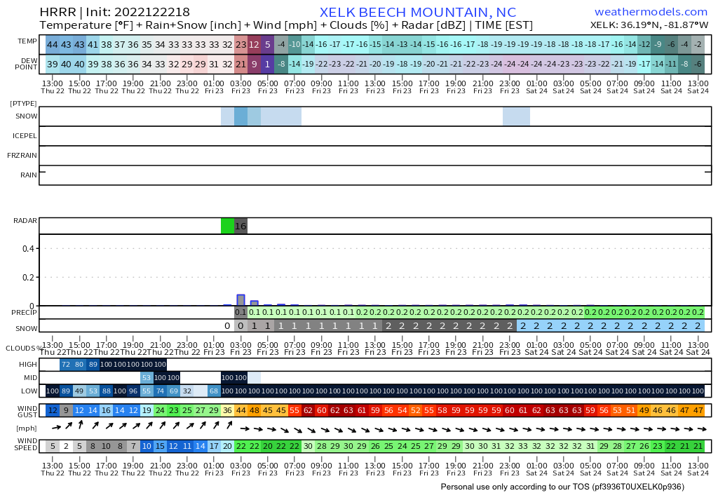
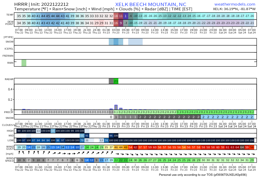
HRRR has Beech Mountain at -20F during the day Friday. Be ready
-
2
-
-
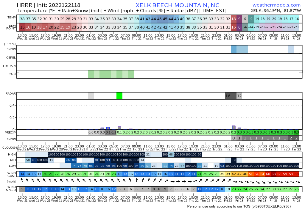
Significant warning occurred overnight with temps rising 12 degrees above 4500’. Cold rain Tuesday
-
1
-
-
16.5 Grandfather Mountain.
12.7 Mount Mitchell
-
5
-
-
AS OF 630 AM EDT TUESDAY: IR SATELLITE CLOUD TOP TEMPERATURES OF MINUS 8 TO MINUS 10 DEC C CONTINUE TO SUPPORT THE POTENTIAL FOR SPOTTY SNOW FLURRIES ALONG AND NEAR THE TN BORDER IN NORTHWEST UPSLOPE FLOW. ISOLATED TO SCATTERED FLURRIES MAY CONTINUE THROUGH THE DAY AS THE SHALLOW UPSLOPE MOISTURE BRIEFLY INCREASES AND A BAND OF VORTICITY ARRIVES ALOFT. OTHERWISE, A DEEP AND COLD TROUGH WILL REMAIN IN PLACE OVER THE EASTERN CONUS THROUGH THE NEAR TERM PERIOD. DESPITE GOOD INSOLATION EVERYWHERE EXCEPT THE SPINE OF THE SOUTHERN APPALACHIANS, MAXIMUM TEMPERATURES WILL STRUGGLE IN THE 50S EAST OF THE MOUNTAINS, WITH PLENTY OF 30S AND 40S ACROSS THE HIGH TERRAIN - RUNNING SOME 15 TO 25 DEGREES BELOW NORMAL IN MANY LOCATIONS!
-
2
-
-
-
-
Fox Weather coming this year along with a new streaming weather service from The Weather Channel
https://www.theatlantic.com/culture/archive/2021/07/fox-news-weather-channel/619408/
-
GSP:
THE ARRIVAL OF THE COLD AIR WILL RAPIDLY BRING SFC TEMPS INTO THE 30S AT HIGH ELEVATIONS BEGINNING LATE EVENING; FREEZING LEVELS WILL CONTINUE TO FALL SUCH THAT MIN TEMPS REACH THE MID 20S IN HIGHER ELEVATIONS IN THE MORNING (MIN TEMP RECORD AT AVL DOES NOT LOOK TO BE IN JEOPARDY). STILL LOOKING FAIRLY IMPRESSIVE IN TERMS OF A NW FLOW SNOW EVENT, WITH THE MAJOR "CLASSIC" INGREDIENTS LOOKING TO COME TOGETHER TO PRODUCE ACCUMULATING SNOW. THE STRONG WINDS AND RAPID COOLING OF THE MIXED LAYER WOULD SUGGEST ABOVE-AVERAGE SLRS, AND A NUMBER OF SOURCES STILL DEPICT A SMALL AMOUNT OF INSTABILITY. STILL THINKING WE WILL SEE A GREAT LAKES CONNECTION; ALWAYS TRICKY TO FIND GUIDANCE THAT PRODUCES BELIEVABLE QPF IN THE UPSLOPE AREAS, BUT FEELING PRETTY GOOD ABOUT SNOW TOTALS OF 1 TO 2 INCHES IN MOST OF THE NW FLOW ZONE, WITH ISOLATED 3". QPF TAPERS OFF AFTER 18Z, BUT AT LEAST SOME FLURRIES MAY LINGER INTO THU EVENING.
-
2
-
-
Coldest Temperatures This Winter
Beech Mountain: 0 degrees (December 26)
Blowing Rock: 7 degrees (December 26)
Boone: 9 degrees (December 26)
Deep Gap: 10 degrees (December 26)
Linville: 5.4 degrees (December 26)
Sugar Mountain: -1 Degree (December 26)
Valle Crucis: 9.7 degrees (December 26)
West Jefferson: 8.9 degrees (December 26)
Snow Totals This Winter
Beech Mountain: 52.7 inches
Boone: 25.7 inches
Sugar Mountain: 78.5 inches
-
1
-
-
31 minutes ago, Wow said:
The ice, as expected, was a bust.
Exactly. Knowledgeable ones knew yesterday it would bust in many areas
This type of bust is really a huge blessing. Our lineman brothers in Virginia especially Southern Virginia cooperatives are still slammed from last Friday night with over half of the customers in Southside Virginia cooperative still out
-
1
-
-
Anyone wishing for ice should think twice
Southside Electric Cooperative in southern Virginia this morning still has 77% of their customers out this morning 48 hours after the event. Their area was torn up by ice
Our lineman need a break. They work harder than any NFL Lineman ever does.
Jacking and restringing wire and establishing equipotential grounding zones around the lineman to protect them from generator back feeds is tedious hard work.
https://poweroutage.us/area/state/virginia-
4
-
-
Avery-Caldwell Mountains-Burke Mountains-
Including the cities of Ingalls, Banner Elk, Newland,
and Jonas Ridge
249 PM EST Thu Feb 11 2021
...WINTER WEATHER ADVISORY IN EFFECT FROM MIDNIGHT TONIGHT TO
NOON EST FRIDAY...
* WHAT...Freezing rain expected. Total ice accumulations of a
light glaze.
* WHERE...Avery, Caldwell Mountains and Burke Mountains Counties.
* WHEN...From midnight tonight to noon EST Friday. -
-
Epic winter still in progress this year.
-
5
-
-
GSP 6 to 10 inches upslope snow inbound in mountains with higher amounts over 4500
-
4
-
-
1 hour ago, Buckethead said:
I like reading that. I got 10.5" from the nwf event in early December.
Never did get my propane though lol. Fortunately I have two other heat sources.
BTW, Suburban Propane sucks.
Sent from my SM-G970U using Tapatalk
Blue Ridge Propane does a good job but I don’t think they cover your area
-
1
-
-
Sperry Piltz Ice Accumulation Index
http://www.usawx.com/icestormindex.htm
-
-
14 minutes ago, CaryWx said:
MJO drives it. In many cases (depending on what you what to see happen) it's the kabal force measure on how these indices will behave.
You are spot on
On Friday the MJO gave signs the implied pattern was going to unravel
Yes it is very disappointing however it has been a great run of winter since 11/29 in western NC with 41 days of general snow cover above 4500’ and already 60” this season in places. Far better than last year
-
1
-
-
BAMWX updated video.
Excellent work.
2022-2023 Fall/Winter Mountains Thread
in Southeastern States
Posted
Appears headed to -20