

Ace
-
Posts
198 -
Joined
-
Last visited
Content Type
Profiles
Blogs
Forums
American Weather
Media Demo
Store
Gallery
Posts posted by Ace
-
-
55 minutes ago, BxEngine said:
I considered it but we watched diners drive-ins and dives while drinking allagash whites instead.
Allagash white is a top tier beer

-
10 hours ago, wdrag said:
Agreed100%. will update by 830A.
Upton is very bullish.
Although the focus of the long term remains Isaias, there is the
potential for a round of significant severe weather on Sunday.

A warm front is progged to be lifting thru the area on Sun. The 12Z
NAM builds SBCAPE to over 3000 J/kg. Sufficient shear puts the BRN
firmly in the supercell range. In addition, A high EHI embedded in
this regime will add a tor threat. It is still too far out to have
high confidence in the details and timing, but the data suggests the
ingredients are potentially there for a svr wx outbreak. Future
forecasts and SPC outlooks will refine this threat over the weekend.
Pops were limited to 50 percent based on the uncertainty, although
the NBM suggests categorical across the interior.
-
 1
1
-
 1
1
-
-
All eyes on Isaias, but Sunday could be a big time severe weather day. Probably more so for upstate NY/PA, but we'll see.
-
1
-
-
4 hours ago, PB-99 said:
The 3k NAM has 2 possible lines tomorrow
Going to be a disgusting day with high dew points (mid to upper 70's!) and high PWAT's. Instability values will be impressive and we may benefit from good timing (afternoon start time). Hopefully we don't get any morning activity to screw us over.
-
1
-
 1
1
-
-
4 hours ago, wdrag said:
Good Friday morning everyone,
You've seen the D2 from SPC issued earlier this morning. Convective debris (leftover) in the morning may minimize potential, but for now... I think a potentially substantial outbreak of SVR, especially near I80 in n PA/extreme s NYS with a possible bookend vortex crossing NYC area (IF---and only IF it's maintained in future NAM/HRRR modeling through the 12z/27 cycle.
I'm viewing this as a two thunderstorm episode day, one early near 12z/27, the other as per GFS/NAM modeling for 22zish. The 06z/26 HRRR has the 12z/27 nicely suggested for our area but I'm hoping the 17z/27 band is wrong (too fast). The HRRR agrees more with the EC. Myself, in heavy convection, I favor the GFS-HRRR.
For mariners, the SPC HREF ens MAX gust is provocative and not sure it can verify? It has the strongest wind in the entire ne USA over eastern LI and adjacent LI waters between 22z/27 and 00z/28. Cold water makes me wonder but what it suggests to me, all of LI is in the mix for a svr episode late Saturday, provided the event occurs after 21z with no convection between 14z-21z over LI. 647A EDT/26
Great discussion. The area you highlighted (N PA/extreme S NY/perhaps Northern NJ) certainly seems to have the best chance at the moment as it appears to be at the intersection of good shear and decent instability. Kinda sucks lapse rates aren't impressive.
The 12z NAM shifts the morning activity north of us (but we still get some debris for a few hours) and keeps us dry in the afternoon too. Parameters still look decent though. In addition, some of the other CAM's get some good activity going in our area in the afternoon.
We'll see what happens, but if we are able to dodge most of the morning debris, I certainly wouldn't mind an early band coming through (early afternoon)
-
2
-
-
Heads up NYC metro. We may have some storms to deal tonight.
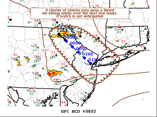
Mesoscale Discussion 0802 NWS Storm Prediction Center Norman OK 0558 PM CDT Wed Jun 03 2020 Areas affected...eastern PA...northern NJ...and southern NY Concerning...Severe potential...Watch unlikely Valid 032258Z - 040030Z Probability of Watch Issuance...20 percent SUMMARY...An organized cluster of thunderstorms across eastern PA is likely to pose at least a marginal threat for strong winds this evening. Limited buoyancy in the wake of previous convection will likely support only limited coverage of storms, and a watch is not anticipated. DISCUSSION...A cluster of thunderstorms over eastern PA has increased in convective intensity over the last hour. These storms are ongoing ahead of a shortwave trough over Quebec and the eastern US. Warm surface temperatures in the upper 70s and and low 80s with dewpoints in the mid 60s F ahead of these storms are supporting MLCAPE of 500-1000 J/kg. A 50-60 kt mid-level jet ahead of the shortwave trough is supportive of favorable deep-layer shear profiles with 40-50 kt of effective shear. The combination of instability and shear should support continued organization of the ongoing storm cluster for a few more hours across portions of New York and New Jersey. Damaging winds will be the primary threat given the linear nature of the ongoing storms and extended but straight line hodographs. Limited spatial coverage and the lack of greater instability due to previous convection will likely limit the threat. No watch is planned at this time. -
The SPC's forecast last night has the main threat for tomorrow to our Southeast (SE PA, S NJ). However, the NAM over the last 2 runs has trended further north with its instability values coinciding with the passing vort being further north. I would sell these high instability numbers that its showing for the 12z run, but could be an active day in the area.
-
1
-
-
Good stuff! @Isotherm
The temp map for the US looks similar to the pattern for the US this week. Impressive heat for the Rockies and the MDT timezone while a persistent northwest flow for us here in the Northeast (near normal) with short lived heat of 1 to 2 days every so often.
-
1
-
-
Flurries here in NE New Jersey!
-
33 minutes ago, Animal said:
Mt Holly nws is calling for rain showers with possible grauple in the heaviest showers.
snow squalls would be unprecedented
Yep the nws offices aren't too impressed, but there is decent activity firing up in Central NY/Northeast PA which matches what the HRRR has been showing. Don't think that snow would be that widespread as shown by that radar loop, but for any places that get into some decent radar returns, perhaps some rain at the onset follow up by some frozen (graupel, some snow) mixing in shortly thereafter? You have a better chance at seeing frozen than those of us close to NYC.
Even in places with no frozen, winds will be interesting.
-
These squalls should be interesting later on
-
3
-
-
Give me any type of frozen precip falling from the sky on Friday night and I'll consider that a massive win...

-
2
-
-
Tornado watch for much of NJ
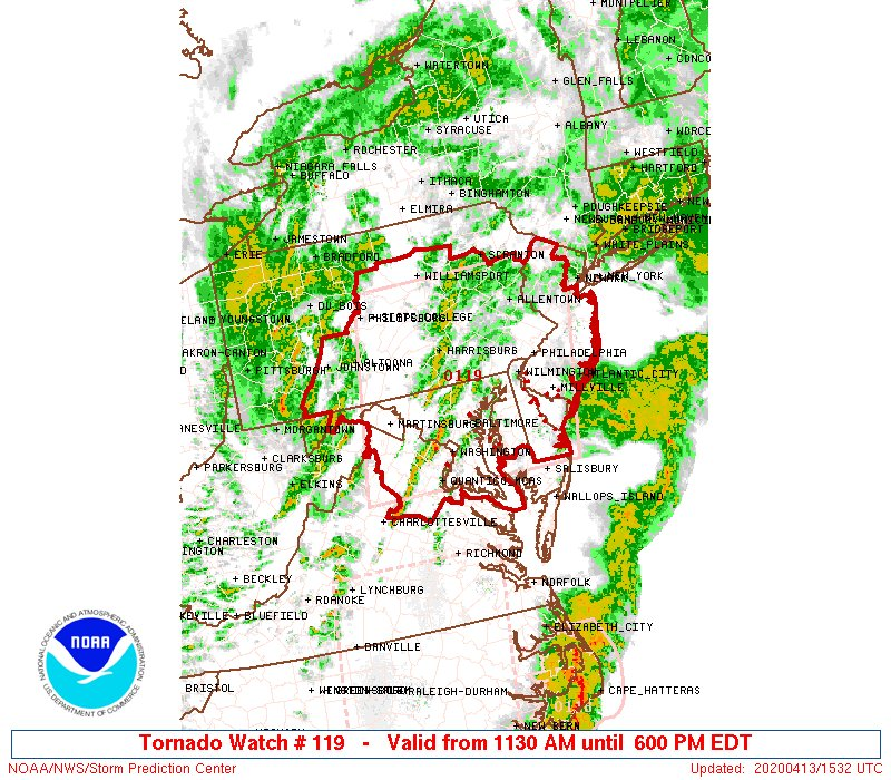
URGENT - IMMEDIATE BROADCAST REQUESTED Tornado Watch Number 119 NWS Storm Prediction Center Norman OK 1130 AM EDT Mon Apr 13 2020 The NWS Storm Prediction Center has issued a * Tornado Watch for portions of District Of Columbia Delaware Maryland New Jersey Central and eastern Pennsylvania Northern Virginia Eastern West Virginia Panhandle Coastal Waters * Effective this Monday morning and evening from 1130 AM until 600 PM EDT. * Primary threats include... A couple tornadoes possible Scattered damaging wind gusts to 70 mph likely Isolated large hail events to 1.5 inches in diameter possible SUMMARY...Clusters of strong to severe thunderstorms will likely develop rapidly northeast across the Mid-Atlantic region this afternoon. Scattered damaging winds are likely and a couple tornadic storms will be possible. The tornado watch area is approximately along and 100 statute miles east and west of a line from 55 miles northwest of Allentown PA to 35 miles south southeast of Washington DC. For a complete depiction of the watch see the associated watch outline update (WOUS64 KWNS WOU9). PRECAUTIONARY/PREPAREDNESS ACTIONS... REMEMBER...A Tornado Watch means conditions are favorable for tornadoes and severe thunderstorms in and close to the watch area. Persons in these areas should be on the lookout for threatening weather conditions and listen for later statements and possible warnings.-
1
-
-
8 minutes ago, Brian5671 said:
Looks like the rain may end for awhile especially western sections-another round later with the biggest winds
Which is scary for those southwest of us. The 13z HRRR has good instability building in Eastern PA/Western NJ, but it happens a bit late. If they get some cloud thinning and instability is able to increase faster than expected, could get very interesting for them.
-
These winds have definitely increased substantially over the past hour for me. Quite impressive if the worst is still to come this afternoon.
-
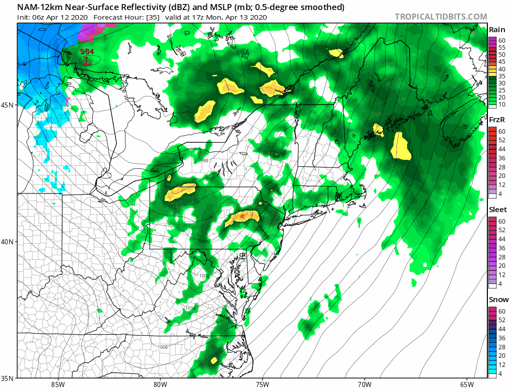
The NAM has trended to a more defined and progressive shortwave aiming it right at us. As a result it is now showing a more condensed line/structure instead of the more diffuse activity it was showing earlier. 3 run change shown below. We'll see how things shift, but this would serve to have a large portion of the area achieve HWW criteria winds.

-
Happy Easter everyone!
One thing I saw on twitter yesterday and I was wondering about, how resistant are those tents in NYC? With those winds predicted tomorrow, hopefully precautions are taken place.
-
1
-
-
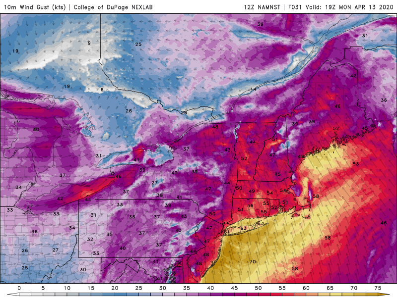
Wind gusts products tend to be mostly useless, but this is probably a decent portrayal by the 12z NAM of what we might see tomorrow . NAM tends to be a bit too inverted while the GFS is too mixed most of the time, so the below is a good conservative portrayal of what the top gusts we'll see tomorrow with a good chance of seeing numbers a bit higher than advertised here
-
1
-
-
4 minutes ago, Barman49 said:
Anyone think the Euro's precip is overdone?
No support from the other models, but I wouldn't be surprised to see the other models trend to it. Seems to be multiple waves of rain on Monday and areas that get hit hard can probably expect over 2 inches.
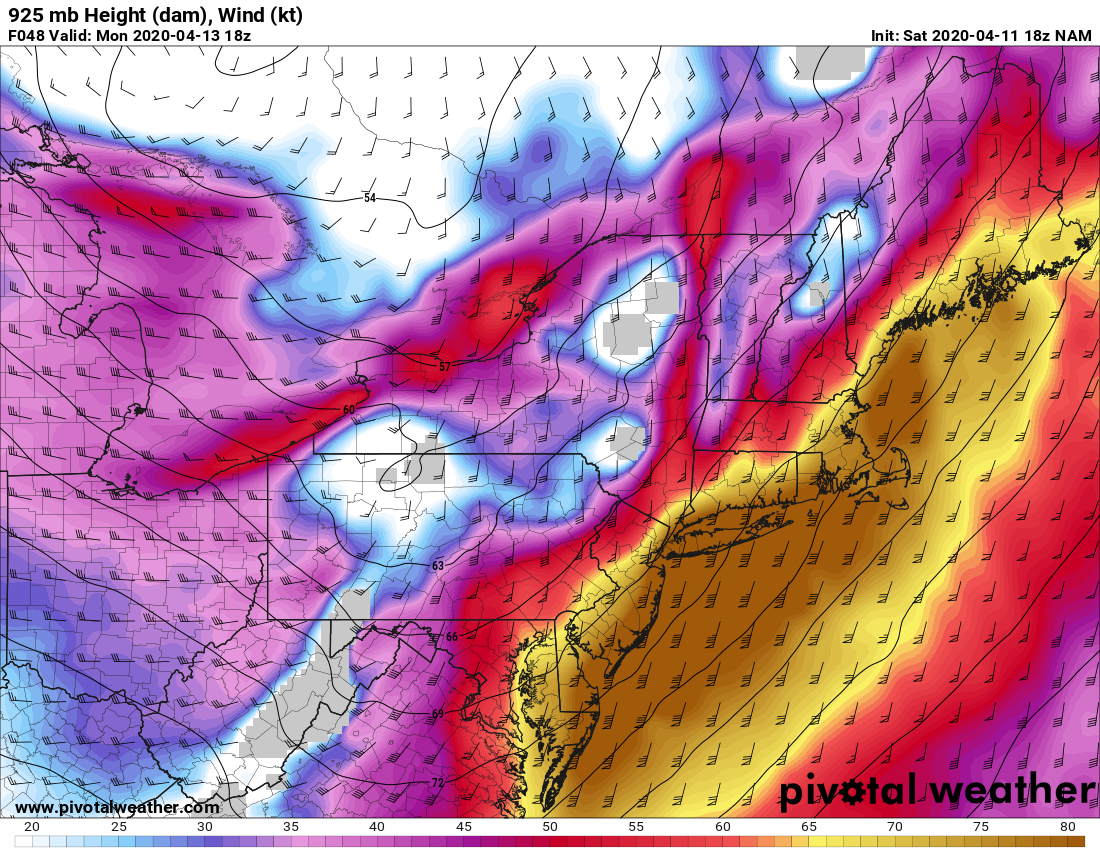
On another note the winds are impressive at 925mb. If we can get into some get convective activity, could bring some of those damaging winds down.

-
2
-
-
21 minutes ago, TriPol said:
Is this going to be like last year where we have a -NAO through the Spring and Summer which gives us a warm, hot summer again? I can't even begin to imagine how bad this summer is going to get.
Last July was certainly hot, but last summer wasn't that bad. 2018 was much worse considering how humid it was that year.
-
1 hour ago, forkyfork said:
Feels like yesterday. I remember the main thread on this forum being full of posts calling the storm a bust in the middle of the storm. Earthlight assured people that the worst was yet to come and then you posted about the NAM showing a MAUL mixing the winds down. Once the wind shift happened, the rest is history.
-
1
-
-
33 minutes ago, LibertyBell said:
2010-11 is such a massive outlier and I suspect that's because it came after a big el nino (2009-10). What was the other case with 40" or more, Don?
I remember that the winter predictions for 2010-11 had it being a poor winter for snow or cold. The pacific wasn't good, but we were saved by massive NAO/AO blocking.
-
1
-
-
4 hours ago, NycStormChaser said:
A timelapse I shot yesterday morning in the Catskills.
Impressive stuff man

-
1 hour ago, Brian5671 said:
el busto. Western edge of rain is much further west than modeled.
We would be all doing cartwheels if it was winter. Looks like a good soaking today and we'll see how far west the rain comes tomorrow afternoon/night
-
1
-

My hand-drawing annual average snowfall map of central to eastern (greater) China
in Weather Forecasting and Discussion
Posted
Great job!