

Ace
-
Posts
198 -
Joined
-
Last visited
Content Type
Profiles
Blogs
Forums
American Weather
Media Demo
Store
Gallery
Posts posted by Ace
-
-
It begins...
-
https://twitter.com/ryanhanrahan/status/1133458403379089408?s=21
Ryan says since we are near boundary we might have good chance at some significant severe storms later. Storms do like to ride the warm front boundary
-
33 minutes ago, SnoSki14 said:
We should've seen the high temperature potential busting this week. Won't get higher than the low 80s and should mainly stay in the upper 70s.
Good news if you hate high heat. Will probably have to wait till July for it.
Persistent SE Canada troughs due to Atlantic blocking has not allowed for any sustained heat for those of us north of 40N. Blocking breaks down in the long range, but no big signal for big heat through Day 10.
-
 1
1
-
-
9 minutes ago, 495weatherguy said:
What happened to the forecasted warmth?
The forecasted warmth for this weekend/early next week is becoming more muted on the modeling. The Euro still likes a brief warmup though for Monday although nowhere near as intense/long in duration as what it showed previously. Areas to our west and south are gonna be the big winners for any warmth on Days 5-7. Modeling is honing in on warmth past Day 9-10 though. Delayed but not denied?
-
GWO and MJO are moving in the right direction. Obviously the stratospheric warming is taking place is well. January is gonna be fun.
-
3
-
-
Just now, psuhoffman said:
Many of our best snow periods came during a -epo and -nao regime. That is what seasonal guidance has advertised for Jan and feb. Thats why many are excited. A -epo + nao pattern is "ok" but not something to be that excited about. Sometimes they work but often they are better for places north of philly and ice or mix to rain events here. It's difficult to get a -nao if the epo ridge is too extreme as that would tend to favor troughing downstream in response. But if the epo ridge isn't too extreme you can get a ridge bridging across into the nao domain too. That's actually our ideal look for snow in the mid Atlantic. It requires an extremely weak PV and negative AO but that's what the idea was. Furthermore the EPS doesn't show an epo ridge. It simply lost the ridging on both sides so I have no idea what your post had to do with my comment on the EPS.
I think that's what he meant. An extreme EPO ridge and western -NAO block probably wouldn't be able to coexist, but a slightly negative EPO and NAO would. His statement was a bit misleading though and one would interpret his words as him saying ridging cannot occur in both areas.
-
19 minutes ago, dendrite said:
Definitely need maue’s new site on there
Agreed. Lots of people have been posting images from weathermodels.com on Twitter lately. I have heard good things about truewx.com as well
-
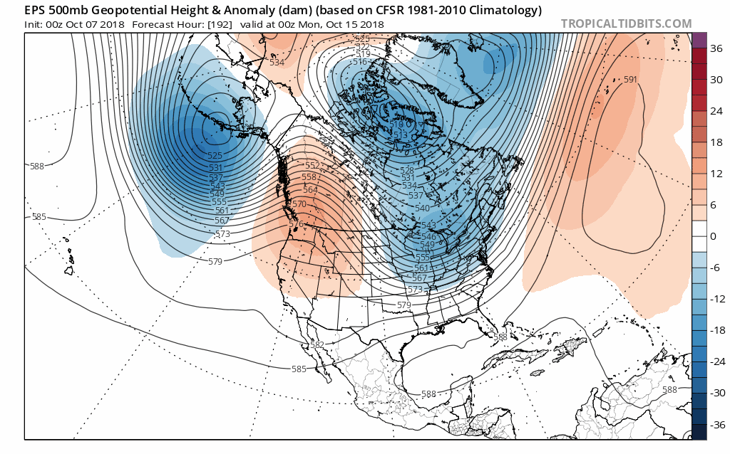
After impressive warmth this week, looks like any cooldown will be brief as the temporary Western Ridge moves east past Day 10.

-
1
-
-
Above average temperatures are on tap for the next two weeks as persistent troughs sets up over the West Coast.
Btw, need a new subscription service for the winter. Weatherbell or Stormvista?
-
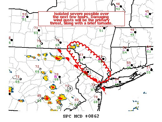
9 hours ago, Rtd208 said:
Day 3 Slight from SPC...impressive. Lapse rates suck though.
-
Good to see the forum back!
-
Cape on the increase. Forcing was looking like an issue, but small cells are popping in New Jersey. Timing may be a bit off though, since the most conductive parameters for rotation may came an hour or 2 after storms roll though. I'm thinking SE NY should get the best storms in a couple of hours.
-
1 hour ago, OHweather said:
Kind of an interesting day Wednesday...
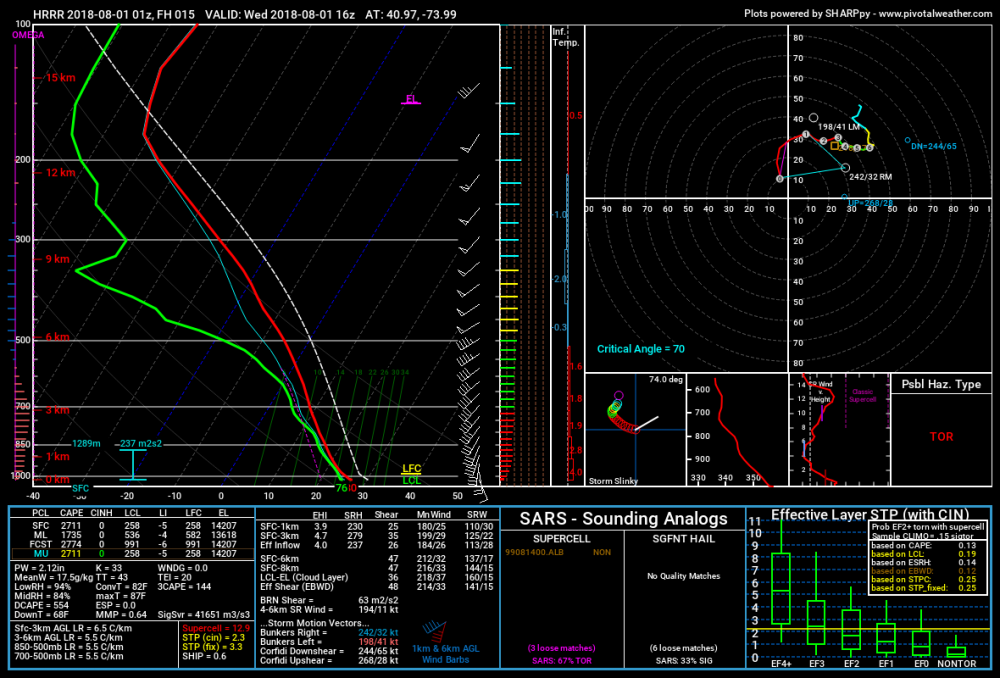
We'll likely get the standard warm advection storms late tonight into the morning. The activity late tonight will initially be a little bit elevated, but by morning we'll quickly erode the low-level CINH and develop some surface-based instability. There may be a narrow window for surface-based storms across central and eventually northern NJ/NYC/extreme southern NY between like 7am-12pm (moving south to north). Low LCLs, 30-40 knots of effective bulk shear, and 100-200 m2/s2 effective SRH will be supportive of rotating storms and perhaps a marginal tornado risk. Most of the Northeast tornadoes seem to be surprise stuff with marginal parameters in the morning, so something is possible. The HRRR solution is slower in lifting those storms north and likely allows them to become surface based across N NJ/towards NYC...the best shot of WAA is a little earlier, so not sure they're quite that slow...but if they are, I do think they'd be supercells with some sort of tornado risk by late morning/early afternoon.
There should be a window in the early to mid-afternoon of some heating, and with a ton of low-level moisture, it won't take a whole lot of heating to get 1000-2000 J/KG of MLCAPE. The CAPE profiles look tall and skinny thanks to atrociously weak lapse rates, but that should still be enough for some decent storms during the late-afternoon and evening. With 30-40 knots of bulk shear and over 100 m2/s2 of effective SRH still through the evening...perhaps even ramping up a bit during the evening as the LLJ ramps up a bit...shear is certainly supportive for anything to be organized and possibly rotating during the late-afternoon and evening. There's no real cap or anything, but forcing also looks pretty weak this far east. Best chances may be from extreme NW NJ (and possibly a little farther west of that) into southern NY in the evening, though if anything were to develop farther east there'd be some sort of gusty wind/weak tornado risk. If the morning activity leaves any sort of boundary that could perhaps be some sort of focus farther east.
I tend to agree with the slight risk being a bit northwest of the bulk of this region...though the morning stuff will definitely have to be watched, with sufficient low-level helicity and low LCLs, it won't take much for a weak tornado with any surface-based storms. The evening stuff I'm more meh on, but I'd rather be in NW NJ than closer to NYC.
Great to have you as part of our subforum OHweather! It is well known that around these parts that warm fronts in the morning have some of our best storms. I think this has good potential. Attached is a sounding of the latest HRRR in New Jersey at 16Z. Check out those LCL's! Overall 3k Nam is a bit similar. This could be a good shot of severe around here as for the mid morning to early afternoon timeframe. At least were not going to watch storms weakening as they travel from west to east as they tend to do most of the time


October 2019 General Discussions & Observations Thread
in New York City Metro
Posted
With the rain on Monday and the potential storm later on in the week, could be a very dreary and unsettled week.