
AllWeather
-
Posts
603 -
Joined
-
Last visited
Content Type
Profiles
Blogs
Forums
American Weather
Media Demo
Store
Gallery
Posts posted by AllWeather
-
-
00z CMC goes full
 over my house
-
 1
1
-
-
4 minutes ago, canderson said:
The consistency is pretty incredible - not much change at all for 4 days now.
I remember Jan 2016 was showing up STRONG in the guidance at 6-7 days out. By day 4-5, there was this kind of consistency and it just locked in from there.
-
1
-
-
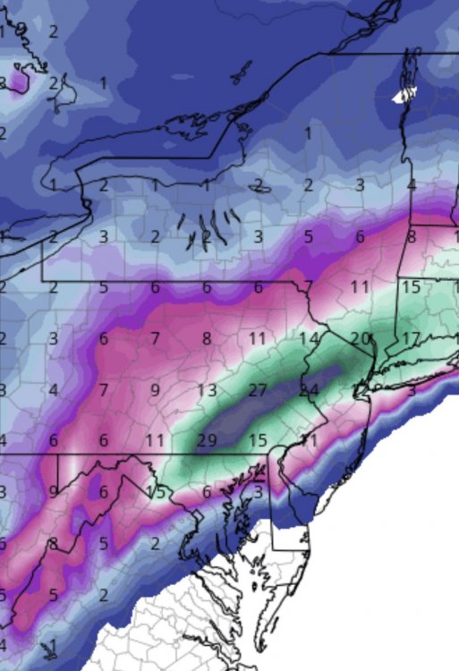
For the LSV folks:
The 00z GFS has 2-2.5” liquid jackpot, all frozen, centered around Adams, York, and Lanc counties. Beautiful deform depiction with strong omega in the DGZ. Those aren’t 10:1 ratios after dark either.
The 00z CMC shows a slight different solution, but the same shellacking on the thump, then a less robust deform band (at least in the LSV), but still puts down 2”+ liquid, all snow, in those same 3 counties - York, Adams, and Lanc.
Pretty remarkable.
-
3
-
-
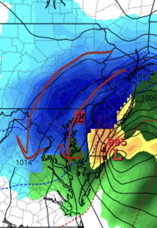
The deform band showing up nicely in the 00z GFS.
-
1
-
-
Just now, paweather said:
Sweetness:

LSV getting hammered this run
-
2
-
-
27 minutes ago, JTrout said:
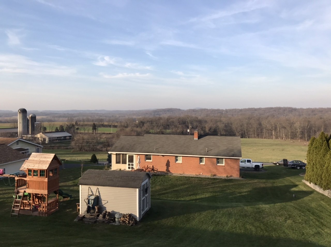
Hey y’all, I just wanted to thank you guys for verifying I am not the only completely insane person around. My wife and I were discussing possibly moving. One of my arguments for staying was the fact that we are on a north facing hill. Good for snow preservation and weather viewing.(I got a dirty look but it’s how I feel!) You guys were discussing things like this a couple weeks ago. Things like piling snow up, mowing the grass short etc. I just did my last mow for the big storm(maybe). Another strategy I have for larger snow piles is shoveling instead of using the snow blower. If I must use the blower, keep the shoot down low and never use salt before the storm. This is the view from the top of my property, very NW tip of Lancaster county.(Elizabethtown)

As a Meteorologist by degree I think you have a prime spot. As a (now) Realtor in LancCo, you definitely have a prime spot.
Win-win for you either way!
-
1 minute ago, paweather said:
Great to see you here!
Thanks! Good to be back.
-
2
-
-
Alright. Now I’m interested.
-
3
-
-
1 hour ago, Cashtown_Coop said:
Yeah sterling all the way for us. I’ll watch state college once in a while for a line of tstorms dropping down but that’s it. The best radar for us lsv folks was when wgal had their live Doppler 8. That had a lower angle and showed great banding detail and had very little virga returns. @AllWeather any plans on making that operational anymore?
Not in the near future, unfortunately.

-
1 minute ago, MAG5035 said:
I put up a post first thing this morning pertaining to my thoughts on the LSV with maybe being a bit warm to start off. I’m not particularly worried. Even if there are issues on the get go, things should quickly turn to all snow and once we get past 3-4pm any surfaces benefitting from the March solar radiation will “cave” when the steadier stuff arrives.
I'm in agreement. If it's 33/34 and puking snow at sunset, you can forget about what the temp is. It'll accumulate.
-
1
-
-
This little bit of overrunning is going to help us stay cool thanks to less insolation/more wet-bulbing. Despite starting a bit milder than guidance, it may all even out in the wash as the main batch moves in. HRRR looks like it's catching up to this idea. Giddy up.
-
 1
1
-
-
8 minutes ago, Cashtown_Coop said:
My fear out here is wasting the heavier rates before sunset. I believe Lanco County jackpots with the best rates after dark. Lastest Euro still targets that area with best qpf
True. It's a catch-22. Best rates after dark in eastern zones, BUT also spots to be warmest that need to be cooled the most. Heck, it's 36 already at LNS.
-
4 minutes ago, Cashtown_Coop said:
33/23 with virga overhead. I don’t think temps go much higher out here
Can't imagine much of a diurnal with virga in your spot. I'm more "worried" about eastern counties.
-
4 minutes ago, Itstrainingtime said:
I'm glad you posted that...I wanted to say that I was concerned about the temperature and dewpoint but figured it was a weenie worry. Yesterday I did mention my concern about a lack of radiation cooling last night and that is exactly what happened.
I provide weather updates for work and told senior management last night that I didn't know what to say...I'm concerned about losing QPF to rain and non-accumulating snow. I'm going to go with 2" - 5" with my morning update. I just don't feel good going any higher.
Yeah I feel dirty going with 7" in our range, but again if we're thumping with 1-2" per hour rates in some spots, it won't take much to pile it on.
-
I'm struggling with this one, to be honest. While many of the high-res & global models show us going straight to snow, the HRRR and the RPM (our in-house model) shows some rain to start with torched BL conditions. Is the HRRR overplaying the warmth? Probably. BUT it is initializing the closest with current obs, as we are a couple to a few degrees milder than the NAM/GFS/EURO...those models have us in the upper 20s right now.
Yeah, we'll likely thump later today with temps cooling, but still slightly above freezing in the best thumping. In that case we'll still see accumulations. I'm wondering if the dyanamic elements producing better than 10:1 ratios helps overcome the burning of QPF on a warm BL.
Anywho, we're going 3-7 for most of the region, especially the LSV, with lower amounts farther north.
-
2
-
-
23 minutes ago, bubbler86 said:
It is a public awareness thing for some but for me it is a curiosity as to their thought process behind it.
They missed the 6 PM news cycle, so most stations have a 10/11 PM (or both), so they may be waiting for the some of the 00z before pulling the trigger.
-
1
-
-
4 minutes ago, Festus said:
Matt Moore (Allweather) this morning showed a southwest to northeast stripe of 3" - 7" across the LSV from Lancaster to maybe Perry county. Then 1" - 3" northwest of that. Pretty much in line with the latest Euro.
Thanks! Yeah, can't deny the trends. Interestingly enough, it's not really like the wave is much weaker (though it is a bit), but also oriented differently now that the northern stream is a bit sharper. So instead of more overrunning, we basically have to rely on a quick stripe of more dynamically driven stuff with the height of the storm.
PS - Did the GFS just score another one?
-
42 minutes ago, Blizzard of 93 said:
Good morning @AllWeather !
What are your thoughts on this storm?
I think you guys have a pretty good handle on it. Reminds me of the November storm. I like 4-8” across the LSV before changing over. More in northern/western spots, especially at elevations. I’ve always tends to underperform from models but could see some 0.25” amounts with a few spots more than that in the typical sheltered “bowls”.
-
1
-
-
12 minutes ago, Blizzard of 93 said:
I agree, but the trend has been colder on the models from 12z ,& the 3k NAM in particular has made a significant jump up with snow totals for the LSV at 0z
Ratios will play a large role, but the trend is there.
No doubt the trend is there. Maybe the NAM scores one here.
Of note is the strong easterly fetch of air by tomorrow morning. Off the mild ocean waters, can be underestimated by guidance. It has burned me several times in the past...
Also, we’re sitting about 3-4 degrees warmer at the surface than the 0z NAM shows in soundings for this time. Not saying it means anything and it could even out in the wash, but something to watch.
Not trying to be a buzz killington here, but these fine line set ups in November tend to pan out more toward the mixy scenario vs. the snowy one.
There’s always an exception though, maybe this one is it? TBD
-
3
-
-
2 minutes ago, Jns2183 said:
Horst wrote on Twitter 30 minutes about how tricky this forecast is and if Lancaster is a degree or two colder then it’s 6”+ for them.
. ProAloft in particular. Riding a very fine line between cold enough throughout the profile to support snow for longer. New NAM holds off the sleet a little longer than previous runs/other models because of the stronger omega in the DGZ, helps keep the column at/below freezing, and staves off the WAA aloft until later in the afternoon.
If the omega is modeled too strong, then you don’t have that opportunity and you change over quickly.
It really could go either way. If it’s all snow, it probably won’t be 10:1. Sloppy, wet, heavy stuff.
-
1 minute ago, Blizzard of 93 said:
The 3k High Res NAM really upped the ante for the LSV on its 0z run ! In previous runs it was only showing a couple inches in York & Lancaster, but now it shows this :

Keep in mind, these are 10:1 output maps. Doesn’t factor in sleet. The model output for rimed flakes/sleet will add up as snow in this format. In this storm, Ferrier Method is superior over 10:1 maps.
Cut those map map totals in half for the LSV, and it still might be overdone. Warm air aloft waits for no one.
-
7 minutes ago, Atomixwx said:
Nice video on the FB, son.
Thanks duderino!
-
3 hours ago, canderson said:
Eric Horst has a 5-8 swath for the majority of this forum. 2-5 elsewhere and .5-2 in the extreme SE.
Edit: Can't get his tweet to embed. URL is:
https://twitter.com/MUweather/status/1062751445450153984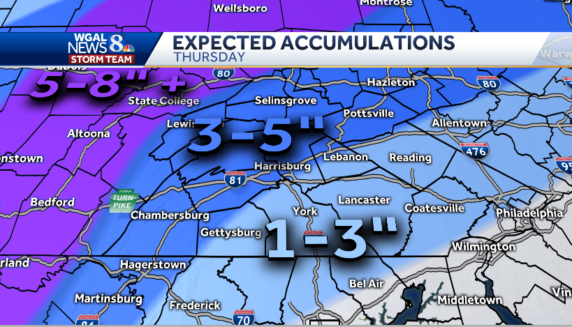
Good to see Eric and our shop are in pretty good agreement:
-
1
-
-
18 minutes ago, bubbler86 said:
Not sure they are allowed to do that. Criteria is criteria.
I just called CTP because I was confused and thought the same thing. They told me that when it comes to WSWarnings, there's a gray area with a mix of snow/ice where they can use their discretion to issue a Warnings or Advisory regardless of what the hard-lined all snow vs. all ice scenario criteria say. Their discretion in this case is factoring in that Dauphin, Lebanon, Cumberland, and Perry counties are more traveled than other counties. So while the amounts will be slightly higher than Advisory levels, the higher population and timing is being factored because it'll be more impactful.
Oh, and hey guys! Winter is BACK!
-
2
-


December 16/17 Winter Event
in Mid Atlantic
Posted
Yupp. And does naughty things.