

LovintheWhiteFluff
-
Posts
564 -
Joined
-
Last visited
Content Type
Profiles
Blogs
Forums
American Weather
Media Demo
Store
Gallery
Posts posted by LovintheWhiteFluff
-
-
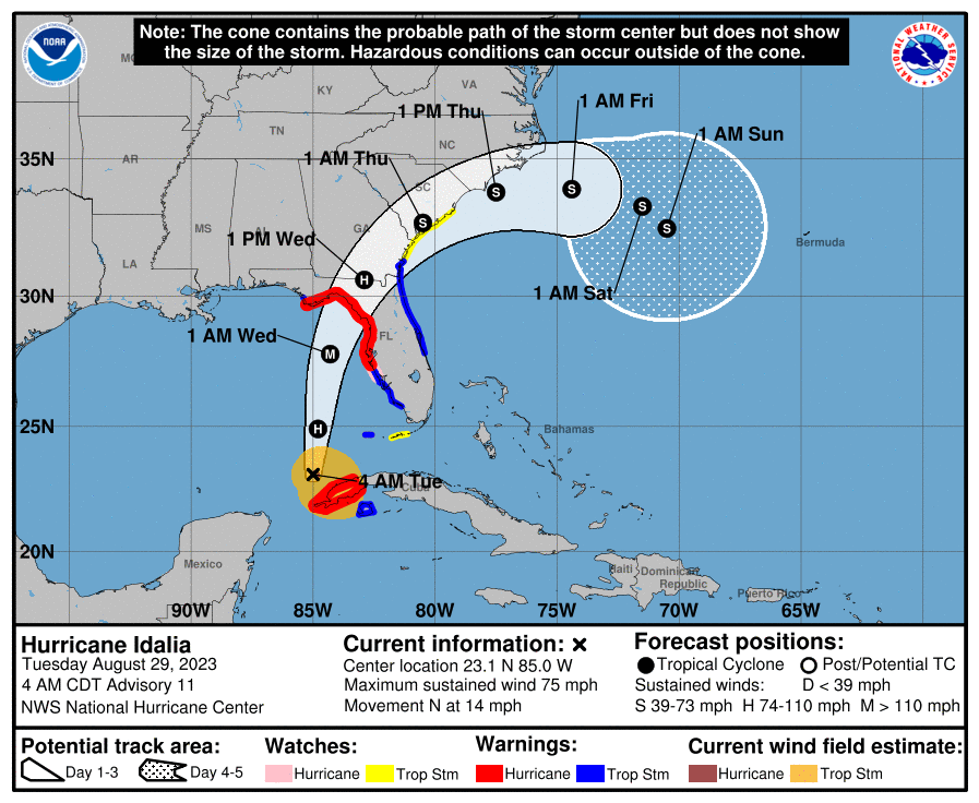
41 minutes ago, wxeyeNH said:
Not a great look for hurricane weary people but still way out there. High pressure blocks the out to sea route

Later in the runs there is a huge high over the eastern part of the US, so it never gets here. Haven't seen the midday Euro yet so can't say anything about that run.
-
You can see here the path it has been taking and the direction it would need to go to landfall where the center of the cone would be.
.thumb.png.fe99a47f81c4f2ef1fcb0c53a6ffcf5f.png)
-
 2
2
-
 1
1
-
 1
1
-
-
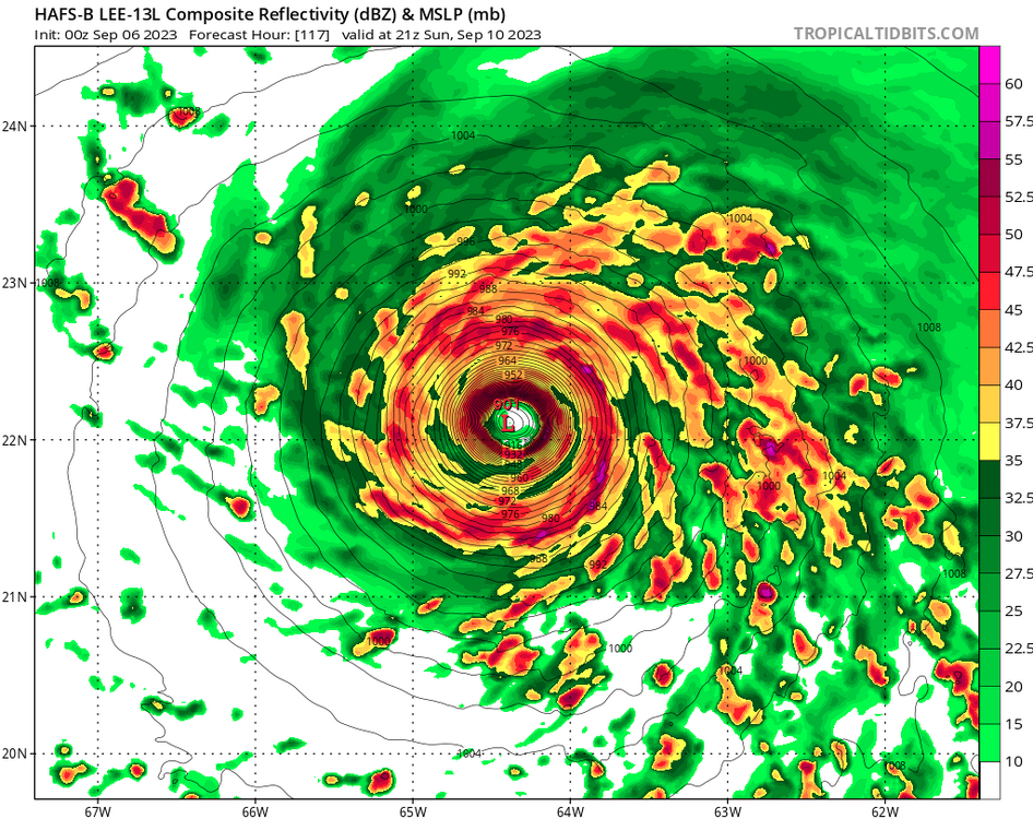
23 minutes ago, olafminesaw said:
Funky things happening in the eye, but does seem to be moving ENE right now (almost due East). Really hard to determine movement with the ongoing structural changes.
Still seems to be generally NNE (edit: last few frames are definitely E)
https://www.wfla.com/video/wfla-com-wobble-tracker/adst9VARmWrkeNkr/
-
2
-
1
-
-
1 minute ago, 40/70 Benchmark said:
Looks to be jogging NNE at the moment.
Someone posted this yesterday. Gives a great view of the movement.
-
1
-
1
-
1
-
-
34 minutes ago, skillsweather said:
Its from the day after tomorrow. I thought that view of the low they got would be a good banter pic of this storm lol
I almost sent this out. Lol
-
2 minutes ago, NJwx85 said:
Last time I checked, 82kts = 94MPH.

963mb is cat 3 pressure.
-
 1
1
-
-
21 minutes ago, jburns said:
Chimney Rock. I was hoping this was fake but I don't think it is. If anyone knows for sure I will delete if faked.

The second picture is further up the road but it looks bad either way.
-
The blue house on the weather channel is getting pummeled with waves.
-
1
-
-
1 minute ago, SchaumburgStormer said:
Down from 942 last pass right? Holy shit.
only down 1mb in last 30 minutes, not 4....couple pages back.
-
 1
1
-
-
1 minute ago, Chinook said:
Ryan Hall stream said that the Hurricane Hunters kind of got stuck in the eye earlier (not sure if this is old news, but I haven't heard of such a thing.)
I believe it happened once before where they had to fly around in the eye and wait for another mission to look over the aircraft on a flyby because of mechanical issues.
-
8 minutes ago, BTRWx's Thanks Giving said:
I want data and not just a picture.
Hurricane-force winds extend outward up to 60 miles (95 km) from the
center and tropical-storm-force winds extend outward up to 310 miles
(500 km).  A weather station at Venice Municipal Airport recently
reported a sustained wind of 46 mph (74 km/h) with a gust of 69 mph
(111 km/h).  Another observation near Venice Beach reported a
sustained wind of 51 mph (82 km/h) with a gust to 66 mph (106
km/h).
https://www.nhc.noaa.gov/text/refresh/MIATCPAT4+shtml/262042.shtml
Add the NOAA graphic:
yellow = TS Force
Red = Hurricane Force
-
1
-
2
-
-
22 minutes ago, Wannabehippie said:
Plus it is very close to the Yucatan, that has to be causing some issues with strengthening IMHO as an amateur.
This area has cooler water due to more upwelling due to westerly winds. This is what I posted in the Beryl thread. The area extends a bit east of the peninsula and north of it. Throw in some dry air with this and you don't get a lot of deepening.
The coastal area north of Yucatan has experienced a cooling SST trend from 1982 to 2015 during the upwelling season (May–September) that contrasts with the warming observed at the adjacent ocean area. Different drivers were analyzed to identify the possible causes of that unusual coastal cooling. Changes in coastal upwelling and in sea-atmosphere heat fluxes are not consistent with the observed coastal cooling. The eastward shift of the Yucatan Current observed over the last decades is hypothesized as the most probable cause of coastal cooling. This shift enhances the vertical transport of cold deeper water to the continental shelf from where it is pumped to the surface by upwelling favorable westerly winds.
-
2
-
-
7 minutes ago, BooneWX said:
Aside, can anyone educate me as to why sea surface temps are always consistently cooler just off the northern Yucatán?
The coastal area north of Yucatan has experienced a cooling SST trend from 1982 to 2015 during the upwelling season (May–September) that contrasts with the warming observed at the adjacent ocean area. Different drivers were analyzed to identify the possible causes of that unusual coastal cooling. Changes in coastal upwelling and in sea-atmosphere heat fluxes are not consistent with the observed coastal cooling. The eastward shift of the Yucatan Current observed over the last decades is hypothesized as the most probable cause of coastal cooling. This shift enhances the vertical transport of cold deeper water to the continental shelf from where it is pumped to the surface by upwelling favorable westerly winds.
https://www.sciencedirect.com/science/article/abs/pii/S0924796317303317#:~:text=The%20eastward%20shift%20of%20the,by%20upwelling%20favorable%20westerly%20winds.
-
2
-
1
-
-
-
4 minutes ago, Conway7305 said:
Look at the pattern on the other charts, not the placement of the low.
-
Should have handed this idiot an anemometer and asked him to get some data on Lee.
-
5
-
-
1 hour ago, Will - Rutgers said:
this is a certainty i saw it in a vision
Stop eating at the RU food trucks.
-
Don't see this too often.

-
 2
2
-
-
51 minutes ago, Eskimo Joe said:
Lul wut
He probably hasn't looked since some models were showing it coming back around to Florida.
-
Just now, WxSynopsisDavid said:
Category 4 130mph with 3am update
4am advisory says 125mph but splitting hairs.
-
2 minutes ago, WxWatcher007 said:
Such an interesting appearance. Extrapolated pressure down to 941.5mb on that pass.
Yeah, down 4mb in last 90 minutes.
-
Most 0z models including HAFS had Idalia leveling off right about now until landfall. Let see what she does.
-
1
-
-
-
000
WTNT45 KNHC 290859
TCDAT5

Hurricane Idalia Discussion Number  11
NWS National Hurricane Center Miami FL       AL102023
400 AM CDT Tue Aug 29 2023

Radar data from western Cuba indicates that Idalia is becoming
better organized.  Most of an eyewall has formed, with much more
curvature in the banding features and overall radar pattern.
Satellite imagery also shows the center of Idalia firmly within the
central dense overcast.  Thus, the initial wind speed is raised to
65 kt, in accordance with the latest TAFB satellite classification.

The hurricane is accelerating northward this morning, now moving at
about 9 kt.  Idalia should move faster to the north or
north-northeast through landfall on Wednesday between mid-level
ridging over Florida and a trough dropping into the western Gulf of
Mexico.  There has been a westward shift in the model guidance
overnight, perhaps due to the trough tugging Idalia more
northward before taking a north-northeast turn.  It should be
noted that the ECMWF ensemble shows many of its strongest members
on the eastern side of its guidance envelope, which is a
reasonable place to be given the synoptic pattern.  The new NHC
forecast is adjusted a little to the west but is now east of the
model consensus on the eastern side of the reliable model guidance.
After Idalia leaves the eastern United States coastline, the track
forecast becomes highly uncertain and little change was made to the
previous forecast.

With an inner core now present, the stage is set for Idalia to
rapidly intensify before landfall. Shear should continue to lower
over the cyclone as an upper-level trough departs the northeastern
Gulf of Mexico and ridging builds closer to the cyclone.  These
changes, combined with extremely warm and deep waters the hurricane
will be traversing, all strongly point to rapid intensification.
The new forecast is similar to the previous one, and confidence is
increasing in an extremely dangerous major hurricane making landfall
Wednesday along the west coast or Big Bend region of Florida.

KEY MESSAGES:

1. There is a danger of life-threatening storm surge inundation
along portions of the Florida Gulf Coast where a Storm Surge Warning
is in effect, including Tampa Bay and the Big Bend region of
Florida. Inundation of 8 to 12 feet above ground level is expected
somewhere between Chassahowitzka and Aucilla River.  Residents in
these areas should follow any advice given by local officials.

2. Hurricane conditions are expected within portions of the
Hurricane Warning area along the Florida Gulf Coast, with the
potential for destructive winds where the core of Idalia moves
onshore. Strong winds will also spread inland across portions of
northern Florida near the track of the center of Idalia.

3. Heavy rainfall is expected across portions of western Cuba and
may produce areas of flash and urban flooding as well as landslides.
Areas of flash and urban flooding, some of which may be locally
significant, are expected across portions of the west coast of
Florida, the Florida Panhandle, and southern Georgia beginning today
into Wednesday, spreading into portions of the eastern Carolinas
Wednesday into Thursday.


FORECAST POSITIONS AND MAX WINDS

INIT  29/0900Z 23.1N  85.0W   65 KT  75 MPH
 12H  29/1800Z 24.9N  84.8W   85 KT 100 MPH
 24H  30/0600Z 27.8N  84.3W  105 KT 120 MPH
 36H  30/1800Z 30.6N  82.9W   70 KT  80 MPH...INLAND
 48H  31/0600Z 32.7N  80.5W   50 KT  60 MPH...INLAND
 60H  31/1800Z 33.8N  77.5W   50 KT  60 MPH...OVER WATER
 72H  01/0600Z 33.9N  74.4W   50 KT  60 MPH
 96H  02/0600Z 33.3N  71.5W   45 KT  50 MPH
120H  03/0600Z 32.5N  70.5W   40 KT  45 MPH

$$
Forecaster Blake

.png.2a97296473d85220ccfc079bfaee2507.png)


Tropical Storm Sara
in Tropical Headquarters
Posted
Probably because it's the end of the season with nothing else going on, and we are a board full of weather enthusiasts.