

LovintheWhiteFluff
-
Posts
575 -
Joined
-
Last visited
Content Type
Profiles
Blogs
Forums
American Weather
Media Demo
Store
Gallery
Posts posted by LovintheWhiteFluff
-
-
Do we get more mm of snow than the amount of emojis in that post?
-
 1
1
-
-
HR48 to H51 is a thing of beauty. Amazing.
-
45 minutes ago, Rjay said:


-
 3
3
-
5
-
-
52 minutes ago, snowman19 said:
No it’s not. For the love of God, stop this
With all due respect, this forum also includes south of NYC, all the way down into Ocean County, NJ.
-
-
12 minutes ago, Krs4Lfe said:
Yes because that’s the likeliest outcome. The latest NWS blend of models has 12 for DC Baltimore and more in Philly. Has 18” for NYC, 24” for Boston. Idk what the national weather service is thinking. This is how they lose credibility. At some point it’s better to save face and just admit that this is a 6-10”. This is why people struggle to believe them. They had NYC at 8” on 12/26, we got 4.” Sometimes their bullish calls can be chalked up to model error like 12/26. But this? This is different. Borderline negligence
The vast majority of the public really doesn't care if a map they put out says 14 inches when it may winds up being 10. They get their weather reports from the news or online. Most people only want to know if they are going to work/school, what time it starts, and if they need to go food shopping. That's it. I'd venture to say it's more important for the public to know 0 inches to 6 inches than 10 or 14. What exact harm is happening to the public if they say 8 and it winds up being 4?
Unlike some people, the pros don't change their forecast model run to model run when a slightly quicker transfer can lead to 14 inches instead of 8 inches.
-
2 minutes ago, Winterweatherlover said:
Ok excited I get but overhyping it as historic/biggest storm in decades etc is a bit much. High end potential it's a MECS probably not HECS.
This is the best one I've seen so far. lol

-
8
-
-
1 minute ago, winterwarlock said:
i think its a joke model but that is has backed off and is usually a snow lovers dream may be saying something..its now the least snowiest model out there
12z GFS was snowier but let's see if it holds now.
-
We probably won't know until Saturday or Sunday since a hour or two quicker transfer means a huge difference in ptype.
-
2
-
-
1 minute ago, winterwarlock said:
ok thanks but it still seems extreme as if they are hugging the gfs
They said in their write-up that they were looking at the ensembles which were closer to benchmark. They think the transfer will happen sooner.
-
1 hour ago, beanskip said:
Why are we dissecting 204 hour panels for a storm that hasn't formed yet and is forecast to behave like a drunken frat guy in the Caribbean for 3 days before eventually, possibly emerging into the Gulf?
Probably because it's the end of the season with nothing else going on, and we are a board full of weather enthusiasts.
-
4
-
-
41 minutes ago, wxeyeNH said:
Not a great look for hurricane weary people but still way out there. High pressure blocks the out to sea route

Later in the runs there is a huge high over the eastern part of the US, so it never gets here. Haven't seen the midday Euro yet so can't say anything about that run.
-
You can see here the path it has been taking and the direction it would need to go to landfall where the center of the cone would be.
.thumb.png.fe99a47f81c4f2ef1fcb0c53a6ffcf5f.png)
-
2
-
 1
1
-
 1
1
-
-
23 minutes ago, olafminesaw said:
Funky things happening in the eye, but does seem to be moving ENE right now (almost due East). Really hard to determine movement with the ongoing structural changes.
Still seems to be generally NNE (edit: last few frames are definitely E)
https://www.wfla.com/video/wfla-com-wobble-tracker/adst9VARmWrkeNkr/
-
2
-
1
-
-
1 minute ago, 40/70 Benchmark said:
Looks to be jogging NNE at the moment.
Someone posted this yesterday. Gives a great view of the movement.
-
1
-
1
-
1
-
-
34 minutes ago, skillsweather said:
Its from the day after tomorrow. I thought that view of the low they got would be a good banter pic of this storm lol
I almost sent this out. Lol
-
2 minutes ago, NJwx85 said:
Last time I checked, 82kts = 94MPH.

963mb is cat 3 pressure.
-
1
-
-
21 minutes ago, jburns said:
Chimney Rock. I was hoping this was fake but I don't think it is. If anyone knows for sure I will delete if faked.

The second picture is further up the road but it looks bad either way.
-
The blue house on the weather channel is getting pummeled with waves.
-
1
-
-
1 minute ago, SchaumburgStormer said:
Down from 942 last pass right? Holy shit.
only down 1mb in last 30 minutes, not 4....couple pages back.
-
 1
1
-
-
1 minute ago, Chinook said:
Ryan Hall stream said that the Hurricane Hunters kind of got stuck in the eye earlier (not sure if this is old news, but I haven't heard of such a thing.)
I believe it happened once before where they had to fly around in the eye and wait for another mission to look over the aircraft on a flyby because of mechanical issues.
-
8 minutes ago, BTRWx's Thanks Giving said:
I want data and not just a picture.
Hurricane-force winds extend outward up to 60 miles (95 km) from the
center and tropical-storm-force winds extend outward up to 310 miles
(500 km).  A weather station at Venice Municipal Airport recently
reported a sustained wind of 46 mph (74 km/h) with a gust of 69 mph
(111 km/h).  Another observation near Venice Beach reported a
sustained wind of 51 mph (82 km/h) with a gust to 66 mph (106
km/h).
https://www.nhc.noaa.gov/text/refresh/MIATCPAT4+shtml/262042.shtml
Add the NOAA graphic:
yellow = TS Force
Red = Hurricane Force
-
1
-
2
-
-
22 minutes ago, Wannabehippie said:
Plus it is very close to the Yucatan, that has to be causing some issues with strengthening IMHO as an amateur.
This area has cooler water due to more upwelling due to westerly winds. This is what I posted in the Beryl thread. The area extends a bit east of the peninsula and north of it. Throw in some dry air with this and you don't get a lot of deepening.
The coastal area north of Yucatan has experienced a cooling SST trend from 1982 to 2015 during the upwelling season (May–September) that contrasts with the warming observed at the adjacent ocean area. Different drivers were analyzed to identify the possible causes of that unusual coastal cooling. Changes in coastal upwelling and in sea-atmosphere heat fluxes are not consistent with the observed coastal cooling. The eastward shift of the Yucatan Current observed over the last decades is hypothesized as the most probable cause of coastal cooling. This shift enhances the vertical transport of cold deeper water to the continental shelf from where it is pumped to the surface by upwelling favorable westerly winds.
-
2
-
-
7 minutes ago, BooneWX said:
Aside, can anyone educate me as to why sea surface temps are always consistently cooler just off the northern Yucatán?
The coastal area north of Yucatan has experienced a cooling SST trend from 1982 to 2015 during the upwelling season (May–September) that contrasts with the warming observed at the adjacent ocean area. Different drivers were analyzed to identify the possible causes of that unusual coastal cooling. Changes in coastal upwelling and in sea-atmosphere heat fluxes are not consistent with the observed coastal cooling. The eastward shift of the Yucatan Current observed over the last decades is hypothesized as the most probable cause of coastal cooling. This shift enhances the vertical transport of cold deeper water to the continental shelf from where it is pumped to the surface by upwelling favorable westerly winds.
https://www.sciencedirect.com/science/article/abs/pii/S0924796317303317#:~:text=The%20eastward%20shift%20of%20the,by%20upwelling%20favorable%20westerly%20winds.
-
2
-
1
-


.png.2a97296473d85220ccfc079bfaee2507.png)

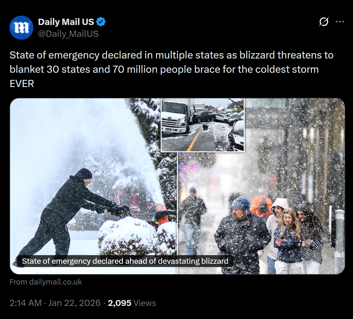
The Allsnow Blizzard of 2026
in New York City Metro
Posted
We have 9 inches in Toms River with tons more coming. It's a paste job too.