

skierinvermont
-
Posts
13,077 -
Joined
-
Last visited
Content Type
Profiles
Blogs
Forums
American Weather
Media Demo
Store
Gallery
Posts posted by skierinvermont
-
-
30 minutes ago, MidlothianWX said:
Radar is beginning to light up. Filling in right over me.
just south of the good stuff here but at least starting to see stuff build up near the foothills on radar
-
36 minutes ago, Wentzadelphia said:
Looking at the radar though Wyoming was the spot for the chase. As Walt drag tells me you always want to be farther N of H5 low. We tried to get out there this afternoon but no transportation. Hoping 2 feet happens still but gonna need some better trends
oh pretty sure you'll see 2' outside shot at 3 still
-
22 minutes ago, Chinook said:
The 3-km NAM still has 2.05" of QPF for me, and that's from 00z, not that long ago, so that would be roughly 20" from 5:00PM onward-- and I've only gotten about 2+ inches since 5:00PM.
I noticed that too.. and almost all that qpf was after 03z.
-
Just now, ValpoVike said:
I am going with absolute faith that the massive gap around Denver fills in soon.
haha right, gaping hole. good thing things seem to be moving quickly still
-
4 minutes ago, MidlothianWX said:
Measured just under 4" as round two ends.
same (3.75 20 min ago)
-
3" here, radar looks to be filling in finally
-
22 minutes ago, STILL N OF PIKE said:
HREF 12z MAX amounts (NOT mean) Thru 12z Sunday (If i am reading that correctly)
18 minutes ago, AlaskaETC said:From the looks of it, the mean is also very generous for most areas.
the mean looks to be about 18" for the metro a little more west a little less east (adding the h24 and h48 totals). around 32" on the mean for Estes, with 47" for the max. more in the higher terrain N and E of Estes
really slams just NW of Fort Collins and up into WY. up to 60" on the mean for the high terrain in WY. 80" on the max.
also 80" max 55" mean near Cameron pass west of Fort Collins
-
 1
1
-
-
almost .5" on the patio table not sticking to the sidewalks at all yet. getting some heavier bursts and then back to a snow rate that is maybe in equilibrium with the melting. gradually getting whiter though.
looks like Longmont to FOCO is a little more consistent right now
-
15 minutes ago, mayjawintastawm said:
?Parker looks like about 20" snow with about 2.0 QPF, about where it was 18 hours ago- so not bad really.
The 00z was a solid .5" more qpf for the whole metro with 2.8" downtown. But the 00z was the most juiced run so far so not surprising to see it tone it back a bit. The mid-level positioning of the low was the same or even a hair south so that was good.
-
sticking to the grass at 5790' here
-
5 minutes ago, MidlothianWX said:
It will be interesting to see what the ensembles say. I know we are very close to game-time now but BOU has said that they are creating their maps based off of ensemble blends.
I mean who knows if it will bump as much as the OP's 40%, but the ridging north of the storm was stronger than 12z beginning from initialization. That ridging has been coming in stronger than modeled on the whole 18z and 00z suite.. pretty much all the models showed this to some extent. That's shunting the mid-level dynamics south and tightening the gradient. So I'd expect some kind of bump.
-
2 minutes ago, MidlothianWX said:
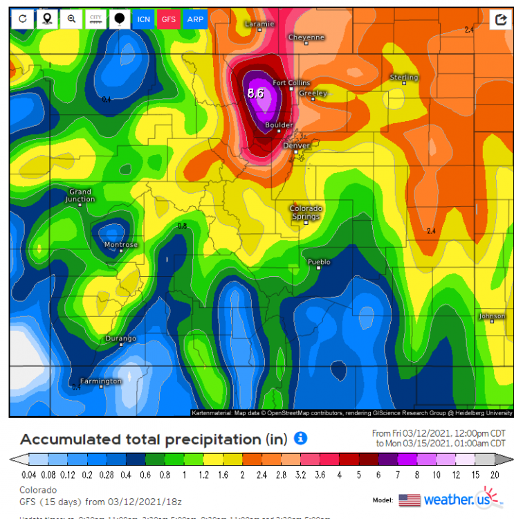
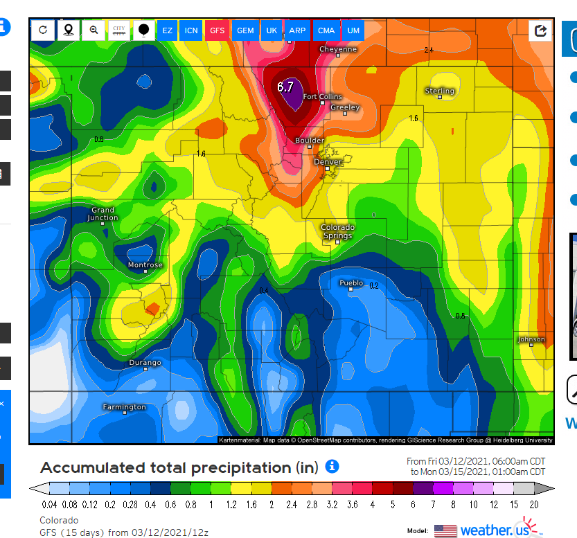
Oh wow, the Euro QPF jump is impressive.
Boulder:
12z: 2.1"
0z: 2.9"
Denver:
12z: 2.1"
0z: 2.8"yeah awesome bump right before the storm after holding solid at 1.8-2.2 for most runs for several days
-
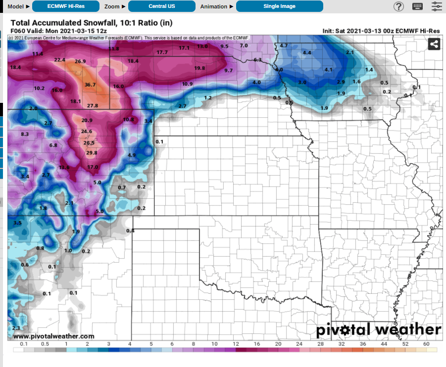
Euro 10:1 maps upped Denver from 19.4" to 26.5"... so 24" with 9:1 ratios
solid 25-50 mile south shift
one more shift like that and the meet of it would be slamming into the northern foothills
-
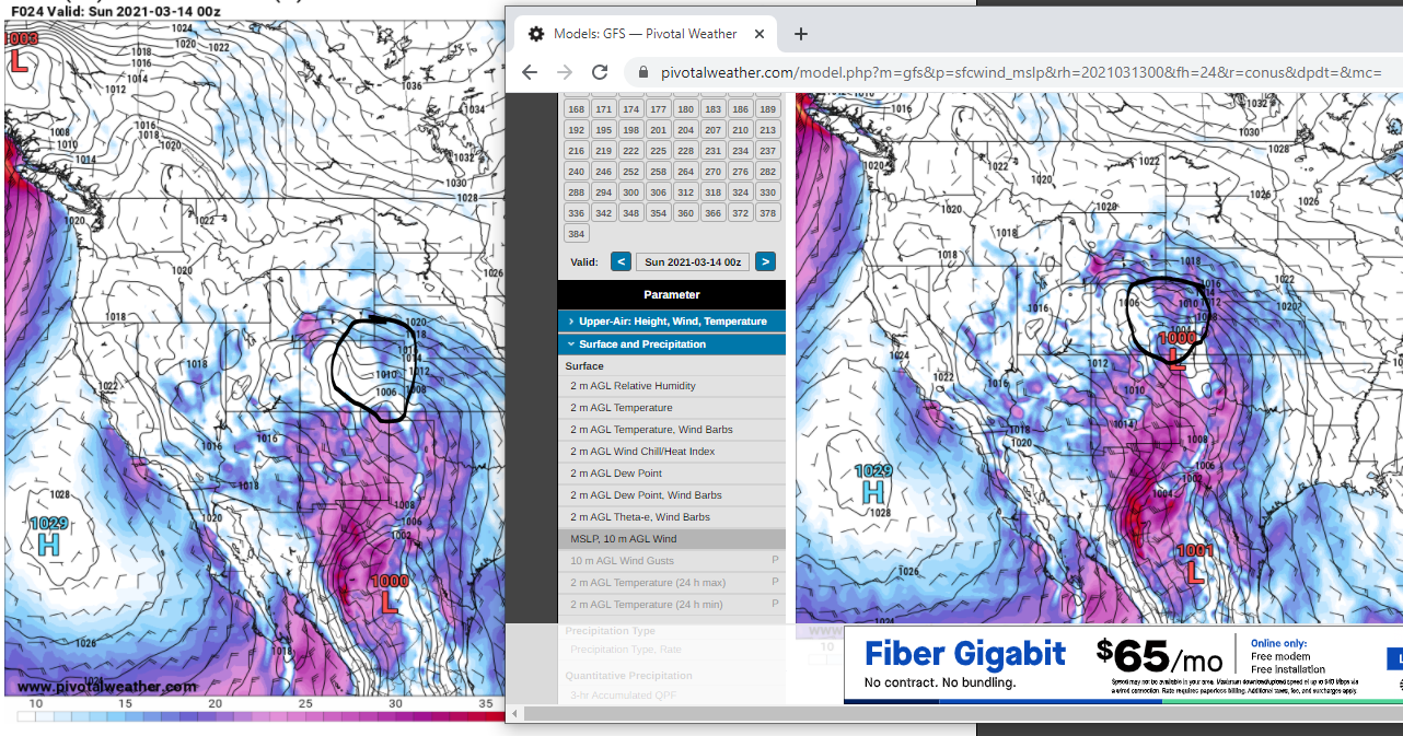
v15 on the right with all the surface wind
-
1
-
-
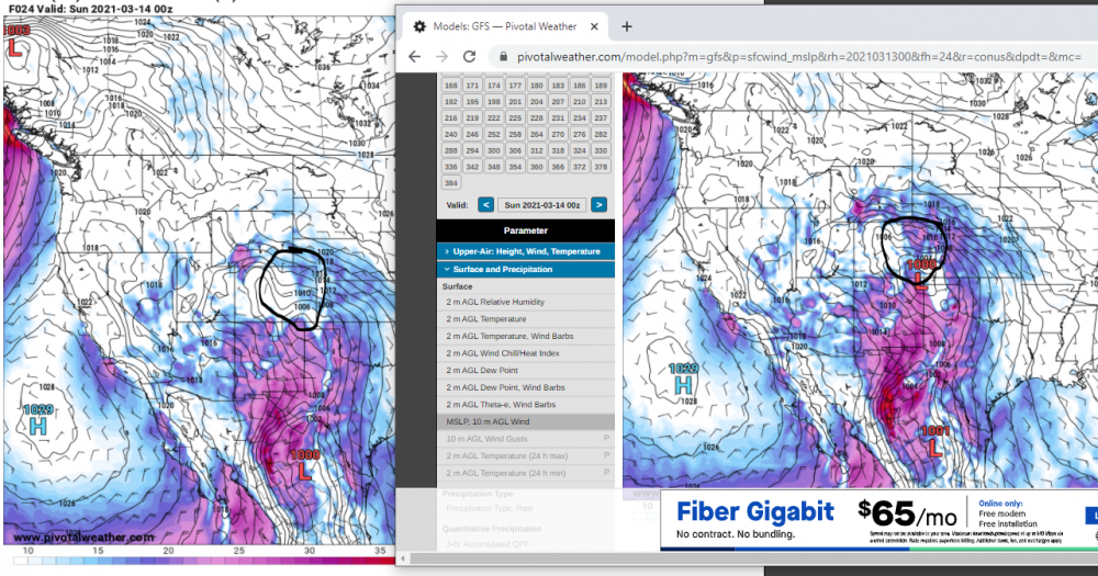
2 hours ago, AlaskaETC said:
I am interested in hearing a more technical analysis of why the Para GFS is colder/wetter than the operational GFS for this storm in particular. The 0z Para GFS is a weenie run for everyone from Denver to Casper.
I do notice the v15 has a lot more surface wind, blowing in the warm air, scouring out the surface cold, and then since there's no resistance until the moisture has to rise over the foothills we get the extreme qpf over the foothills instead of I25
-
1
-
-
maybe the GFS has less cold air damming against the foothills? would also explain the lower QPF farther east. I remember the cold air damming 38" storm in Burlington Jan 2010. Cold air damming was so extreme the mountains barely got snow.
-
1
-
-
2 minutes ago, smokeybandit said:
It's the worst run yet for my back yard. Literally no snow through sunday 0z
yeah i was looking more up north east of FOCO. I see yeah not much down by you and warm
-
People east of I25 will like the new GFS. really fills it in like the other models
-
1
-
-
26 minutes ago, AlaskaETC said:
Agreed. I lived in DC a few years ago. The snowstorms here are great, but Nor'easters are just entirely different and uniquely magical.
In my 6ish years here I think the most I've seen is around 18" and that was probably the only one above 15". Hoping this has the noreaster feel with long duration heavy snow.
I think there are a couple reasons this thread isn't as lively as a MA thread
1) This was originally an east coast only forum
2) There are ballpark 80 million people from NC to ME or 60 million from DC to Boston compared to maybe 3 million from Pueblo to Cheyenne east of the divide. In the same distance (200 miles) from DC to NY there are close to 50 million people. The population density in the east is over 10x.
3) Snow is more frequent here and also the terrain means usually snow is more isolated rather than tracking a single storm that will affect 60+ million.
-
2
-
-
1 minute ago, AlaskaETC said:
0z NAM appears to have most of the action in the front range and central Wyoming, extending into South Dakota and parts of Nebraska. Denver still gets decent totals.
Yeah it was a solid shift south from 18z.. starting to look more similar to the globals' mid-levels. no longer stupidly taking the 500mb low over denver
-
10 minutes ago, Wentzadelphia said:
I’m literally on the plane now. I’m worried when I get there roads will be closed to Estes and I won’t be able to get in. Then it’s bolder, but we’ll see. This is earliest I could leave
When will you be driving to Estes? I think the earliest they would close is sometime mid-morning. More likely they don't close until sometime tomorrow evening or night when the Euro shows a second wave of heavy precip moving in. CO can handle snow, it's just the 40" that overwhelms the roads.
-
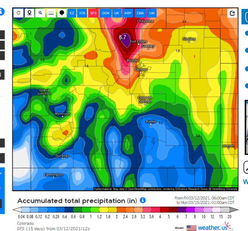
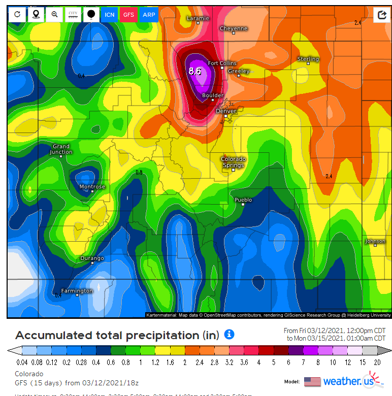
Boulder went from 2.6" to 5" qpf from 12z to 18z gfs... lol... a little erratic to be doubling qpf right before the storm
18z
-
3 minutes ago, AlaskaETC said:
The ECMWF looks extra juicy this run, at least for my area.

yeah generally it seemed to tack on an extra .1-.2" from Colorado Springs to FOCO due to the slight shift south at the mid-levels
less in northern WY and SD
-
1
-
-
Euro shifted south 25 miles. One more shift like that and we will be getting back closer to the 3" amounts near boulder
Front Range snowstorm nowcast/conditions 3/13-15
in Central/Western States
Posted
Time for a walk!