

skierinvermont
-
Posts
13,085 -
Joined
-
Last visited
Content Type
Profiles
Blogs
Forums
American Weather
Media Demo
Store
Gallery
Posts posted by skierinvermont
-
-
I think it's the kicker coming down out of Canada behind it at hr 30-36 .. everything in Canada is sped up and starts pressing down again sooner
-
Euro digs the trough a bit more at 6hrs PV pulling out more
-
21 minutes ago, codfishsnowman said:
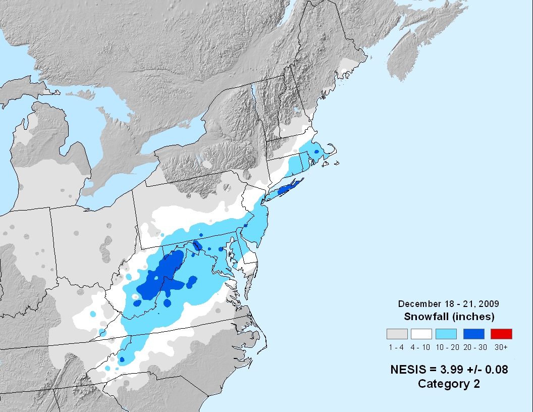
JAn 2015!!! DEC 2009
Isolated at best
-
5 minutes ago, powderfreak said:
I’ve always thought that RI and parts of SE CT can be in a bit of a hole from the massive amount of on-shore convergence and lift in SE Mass. Speed convergence from sea to land, coastal front, just massive pile up of air that rises in SE Mass and then a sinking air couplet past that lift into RI or even adjacent CT. Almost like a mini-standing wave like you’d see in orographics.
Not saying it happens always or whatever, but in a fluid atmosphere one can envision that sort of monster low level lift in SE Mass having a ying to its yang downstream.
Then further west of that you get into mid-level lifting/banding.
We see it in Springfield MA as well on more due east winds too I think. That's a combo of the terrain and coastal convergence
-
3 minutes ago, powderfreak said:
I’ve always thought that RI and parts of SE CT can be in a bit of a hole from the massive amount of on-shore convergence and lift in SE Mass. Speed convergence from sea to land, coastal front, just massive pile up of air that rises in SE Mass and then a sinking air couplet past that lift into RI or even adjacent CT. Almost like a mini-standing wave like you’d see in orographics.
Not saying it happens always or whatever, but in a fluid atmosphere one can envision that sort of monster low level lift in SE Mass having a ying to its yang downstream.
Then further west of that you get into mid-level lifting/banding.
That makes perfect sense. I think I knew that in the back of my mind bit didn't put it all together. You see it all the time. Yes those onshore winds would slow down and pile up in Eastern MA causing convergence and rising air.
-
 1
1
-
-
6 minutes ago, nianticct said:
Your way off base! New london Dec 19 2009 23 inches plus many more storms over the years ! It's either Temps or bad banding that screw us!
23" is less than 24" and is common in the rest of sne. I only measured 19" in that storm. 100 years of bad banding isn't bad luck it's downsloping combined with being too far se for most storms.
-
5 minutes ago, 203whiteout said:
What is downsloping? I’m on the coast here in Fairfield CT and it seems we have had a pretty good run here with 2’+ storms. 2006 was great for us (30”), 2013 was great (35”) we do well with those (further west than modeled) death bands. They seem to set up in a similar location every time almost running through interior Maine SW through NH/VT and then south through western Mass and western/central CT. Hope you guys do well with this one.
the sinking air from the ORH hills and NE CT is the opposite of what you need for precip which requires rising motion and condensation
I think just being farther west in an area that is favored by storm track is key for Fairfield and New Haven counties. Might make up for the downsoping. But Lyme CT may not have ever seen a 24"+ snowstorm in 100 years, while they seem to occur regurarly in coastal Fairlfiend and NHV counties. -
9 minutes ago, Ginx snewx said:
I wasn't talking about Moosup. Westerly had 25 inches on the shore. Also Jan 15 Groton had 25 with N winds
Yeah I saw the Jan 15 at Groton. It's patchy though. I'm pretty confident my parents have never had 2'+ in the last 25 years. And I don't think they would have in 96 or 78 either. So possibly never? Maybe in 78.. I couldn't find a detaled map for that one but I thought the bigger totals were east
-
-
6 minutes ago, Ginx snewx said:
12 21 09
I believe I measured 19" in that one, NWS map shows 10-20" for SE CT no 20"+ spots, although I don't doubt they occurred. Moosup is way different
-
5 minutes ago, SouthCoastMA said:
depends on where. I lived in Wareham during 05 and they had over 28". I think they came close in 15 as well, if not over 2ft. maybe further west towards like Westport/Fall River they have been harder to come by
yes I think the downloping is worse from Westport/Newport over to the CT river. Only 12-18 for SE CT in '05
-
10 minutes ago, bristolri_wx said:
I'm not discounting your theory it may end up being less in the locations you mentioned, but I'm sure that all of the locations you have mentioned have seen two feet of snow on a few occasions in the last 25 years. But yes, very rare, and almost never a jackpot location in this setup.
Growing up in SE CT where my parents still are, I'm fairly sure then have never seen 2'+ in 25 years.. I'm pretty sure that whole area from SE CT to couth coast MA is 0-2 times in 100+ years. Primary option is '78 or '96, but some areas missed out. All south coast 1969.
-
1 minute ago, 40/70 Benchmark said:
You mean south coast...south shore gets 2' often.
New Bedford had 2' in Jan 6, 1996
south shore is the coastline south of Boston right? Yeah I meant south coast. Yeah looking at records from SE CT to the south coast it's like most places either never saw 2'+ or saw it once or twice in '96 and/or '78
-
1
-
-
10 minutes ago, CT Valley Dryslot said:
The H7 low is well offshore from us, so there's no mid-level dryslotting
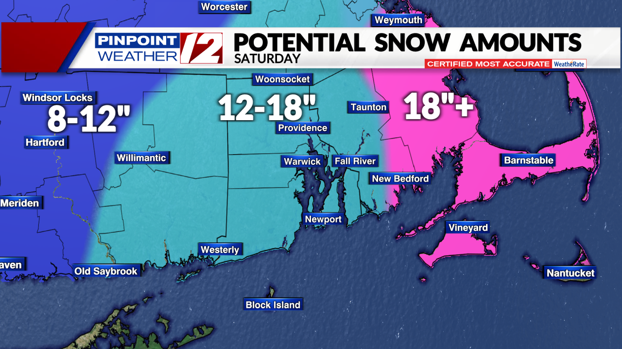
Sure but you have to consider the downsloping and climo.. all the models show a gap in the snow there. SE CT, S RI and south shore of MA have basically never seen 24"+, maybe once, and 18"+ is extremely rare.
And yet almost all the maps have these areas in either 18"+ or 24"+
-
BOS went from 0.3" to 1.6" of QPF from 00z to 18z
-
1
-
-
-
-
2 minutes ago, WeatherWilly said:
The dominoes have started falling. Forecasts being upgraded from 8-12 to 12-18, still somewhat lower than NWS.
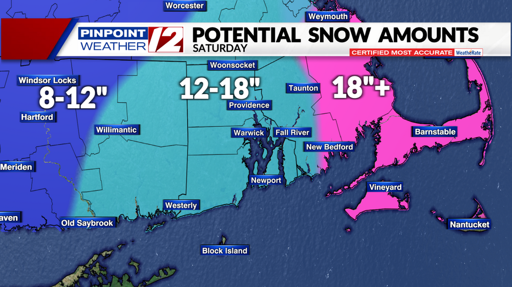
It's odd, none of the forecast maps I've seen show the snow hole in SE CT and SW RI that almost all the computer runs show. With N winds downsloping and climo it seems likely
-
The GFS initialized the PV and heights over Canada a smidge farther NE. I mean I'd give 70% chance the GFS ticks west before even seeing that
-
1
-
-
9 minutes ago, mattm4242 said:
Harvey not messing around. Wow!
It should be noted that Providence has only one recorded storm over 24".. '78 and the areas farther south likely have had none
-
3
-
-
by 30hr you can see some slight extra digging on the backside of the trough, but the extra confluence looks to dominate
-
1 minute ago, Henry's Weather said:
riiiight, its an undesirable solution because it's a bad model
it's a terrible model. this is just entertainment. was hoping for a sub 960mb BM stall
-
1
-
-
7 minutes ago, ORH_wxman said:
Def more confluence up in Quebec on 18z NAM through 18h....
yep not looking good, maybe the trough can somehow slow down but doubtful. I don't know why they don't either improve the initialization of the NAM or toss it
-
I mean what is the point of a model that has such massive 500mb shifts in its initialization from run to run
but the trough does look more amped
Powerful Multi-regional/ multi-faceted east coastal storm now above medium confidence: Jan 29 -30th, MA to NE, with snow and mix combining high wind, and tides. Unusual early confidence ...
in New England
Posted
I don't think so.. the heights are higher over NE at hr 18
The 537mb contour is through the Berkshires instead of Springfield