

WestTennWX
-
Posts
87 -
Joined
Content Type
Profiles
Blogs
Forums
American Weather
Media Demo
Store
Gallery
Posts posted by WestTennWX
-
-
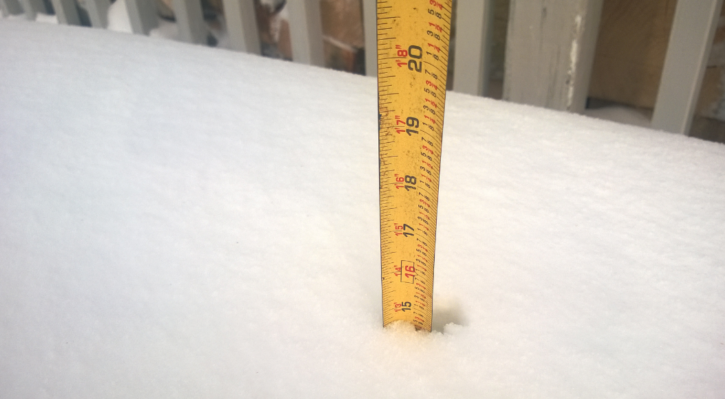
It will be interesting to see how these ratios come into play. It is so freaking cold (8 degrees with a -6 wind chill this morning) that any bit of moisture is squeezed out as snow. Steady flurries/light snow overnight has already covered the roads here in Obion County.
-
 2
2
-
-
6 hours ago, AMZ8990 said:
I was trying to think when the last 5-6+ event was for Memphis and the surrounding areas. I feel like it’s been atleast 21 years cause I don’t ever remember a storm that big in my time living here. Not sure what happened In the 90’s but I’m pretty sure 1985 had a 10+ event in Memphis that year. I know northwest Tn has had some big events in the past 10-20 years though, especially the TN/Kentucky border counties.
The last major one for me (Nw TN) was March 5th of 2015, we got slammed with around 12-15 inches. There were a couple of back to back systems that week as well if I remember it correctly. Measured this off my sidewalk this next morning.....maybe a repeat coming??

-
4
-
-
5 minutes ago, Carvers Gap said:
Might not hurt to add Middle/West TN to the thread title or tags so when we go back and search(in future years), it will be easier to find....
Gotcha, edited!
-
2
-
-
1 hour ago, AMZ8990 said:
We can make a new one or we can integrate into the thread westtnwx made. I’m flexible either way. If westtnwx doesn’t respond by lunch then we can make a new thread though.
I went ahead and edited the existing thread, if someone wants to make a new one I'm totally fine with that. Looking forward to the discussion either way.
-
 1
1
-
-
1 hour ago, AMZ8990 said:
At WestTennWX, would you be willing to change the name of this thread so we can integrate the Monday -Tuesday system in it as well?
No problem. Hoping we all cash in this week!
-
2
-
-
50 minutes ago, Shocker0 said:
It seems like this storm hasn't put down near as much ice as expected...is that correct?
I would say so. Perhaps some of the more knowledgeable guys can chime in on this one, but the ice didn't seem to accreate on the trees and power lines much, thankfully. We had several bursts of heavy freezing rain overnight, maybe runoff was an issue. Either way, I'm thankful. I'm as big of a winter weather fan as the next guy, but these ice storms aren't much fun. Hope we all score on some snow this coming week though.
-
2
-
-
Changed over to sleet here in northern Obion County about an hour ago. Roads are a mess but tress and powerlines actually look pretty good. Heard thunder a time or two up here as well!

-
3
-
-
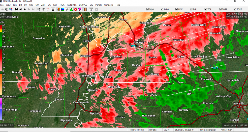
These little bands on the southern end are putting down some ZR pretty quick. It will be interesting to see what pans out v/s projected.
-
3
-
-
17 minutes ago, John1122 said:
I feel like you're going to have about a week long show. I hope you're stocked up and have back up power and are able to enjoy winter's wrath.
Absolutely. Plenty of firewood and the generators are gassed up. I'm having a feeling some of my less prepared family members will be over in the next few days though!
Just had a band of fairly heavy freezing rain pass through. Probably a good 1/10 on elevated surfaces now.
-
3
-
-
Steady freezing drizzle has picked up to light freezing rain here in Union City. Been at 30 most of the afternoon, waiting on the main show tonight.
-
5
-
-
Fairly strong working out of Memphis in this evenings discussion. Wouldn't be surprised to see some of the official expected totals to increase a bit.
A significant ice storm appears likely across portions of the Mid-
South over the next 48 hours as moist air is forced over the top
of a shallow arctic air mass. The forecast is complicated enough,
but the messaging of hazards covering multiple periods is even
more so. In trying to simplify the process, we`ve opted to start
the Ice Storm Warning to 6 PM this evening for portions of
northeast AR, the Bootheel, and northwest TN. The remaining areas
in the Watch remain unchanged. Now for the nerdy part...

A broad trough is affecting much of the CONUS this afternoon with
a deep vortex centered southwest of Hudson Bay. The flow aloft
remains quasi-zonal with a low-amplitude shortwave trough located
off the CA coast. Closer to home, the quasi-stationary arctic
front extends across north MS into middle TN, separating
temperatures in the 20s and 30s from those in the 50s and 60s.
Automated stations currently range from 28F at Kennett (MO) to 68F
at Aberdeen (MS). Light freezing rain has already occurred in
Jonesboro this afternoon and temperatures aren`t expected to warm
much, if at all, over the next 24+ hours.

We`re watching a strong upper tropospheric jet over the Great
Lakes which will enhance large scale ascent tonight via the
thermally direct circulation in the absence of strong QG forcing.
Isentropic ascent will increase overnight, especially in the
285-290K layers. This will maintain broad lift, resulting in
periods of freezing rain and freezing drizzle north of the quasi-
stationary front. While significant accumulations of ice aren`t
anticipated tonight, there may be enough to create some travel
issues along/north of a line from Harrisburg, to Dyersburg, to
Martin. With this in mind, we went ahead and pushed the start time
of an Ice Storm Warning up to 6 PM this evening, running through
noon Thursday. We won`t see freezing rain or continuous impacts
throughout the duration of the warning as the main focus still
lies in Wednesday night into Thursday as QG forcing for ascent
increases and rain/freezing rain becomes more widespread.

As we saw yesterday, warm advection in the layer around 850 mb
will produce a prominent warm nose around 6-8C. The subfreezing
air north of the arctic front will only be up to 2000 ft deep,
resulting in a classic freezing rain/drizzle sounding. As the cold
air deepens, we may see some sleet (and perhaps some snow) mix in,
but freezing rain looks to be the predominant weather type at the
onset. The front will sag south Wednesday night and Thursday,
allowing the subfreezing air to to approach the I-40 corridor. The
southern extent of where the freezing line will set up by 12z
Thursday is a huge area of uncertainty. This makes the forecast
less certain from Memphis to Jackson but points to the north look
more certain to see significant ice accumulations.

The 25th-75th percentiles ice accumulations for the whole event
range from roughly 1/4 to 1/2 inch of ice from Jonesboro to
Union City. Worst case scenario (90th percentile) has a full inch
of ice in this swath with near 1/2 inch as far south as Memphis
and Jackson. On the other end of the spectrum, the 10th
percentile calls for roughly 2/10 within the Ice Storm Warning.
Needless to say, an inch of ice would be devastating. With all of
this in mind, the official forecast of up to 0.35 inches of ice is
quite conservative and may need to be increased depending on
where the bands of heavier rain develop. We`re certainly watching
this closely and will adjust as needed.

This system looks to move east of the area Thursday evening with a
wintry mix possible as precip winds down. Little in the way of
additional accumulations are expected after sunset. Then the cold
air settles into the Mid-South. We`ll see several days with highs
in the 20s/30s with lows in the teens. Wind chill readings Friday
and Saturday will be quite cold, approaching single digits in
some areas. A fast-moving trough will bring a chance for very
light snow to portions of the area Saturday evening, but no
impacts are anticipated. A reinforcing cold shot will arrive by
Sunday (and Monday), where wind chill values may fall below zero.

Another deep trough is progged to affect the region early next
week, bringing another chance for snow to the Mid-South. Given
the plethora of moving parts between now and then, confidence
remains limited but low PoPs were included Monday and Tuesday.
-
1
-
-
Looks like Memphis finally pulled the trigger-
URGENT - WINTER WEATHER MESSAGE
National Weather Service Memphis TN
254 PM CST Tue Feb 9 2021

...Significant Ice Accumulations Expected Across Portions of the
Mid-South Through Thursday...

ARZ009-018-026>028-MOZ113-115-TNZ001>003-019-100600-
/O.UPG.KMEG.WS.A.0001.210211T0000Z-210211T1800Z/
/O.NEW.KMEG.IS.W.0001.210210T0000Z-210211T1800Z/
Clay-Greene-Craighead-Poinsett-Mississippi-Dunklin-Pemiscot-Lake-
Obion-Weakley-Dyer-
Including the cities of Piggott, Corning, Paragould, Jonesboro,
Harrisburg, Blytheville, Kennett, Caruthersville, Tiptonville,
Union City, Martin, Dresden, and Dyersburg
254 PM CST Tue Feb 9 2021

...ICE STORM WARNING IN EFFECT FROM 6 PM THIS EVENING TO NOON CST
THURSDAY...

* WHAT...Significant icing expected. Total ice accumulations of
  two tenths to three tenths of an inch. Some sleet may also
  occur.

* WHERE...Portions of West Tennessee, East Arkansas and
  Southeast Missouri.

* WHEN...From 6 PM this evening to noon CST Thursday. The first
  round of ice accumulations is expected tonight. Greater
  accumulations are expected Wednesday night into Thursday.

* IMPACTS...Power outages and tree damage are likely due to the
  ice. Travel could be nearly impossible. The hazardous
  conditions could impact the morning or evening commute.

PRECAUTIONARY/PREPAREDNESS ACTIONS...

Travel is strongly discouraged. If you must travel, keep an extra
flashlight, food and water in your vehicle in case of an
emergency. Prepare for possible power outages.

The latest road conditions for the state you are calling from can
be obtained by calling 5 1 1.
-
1
-
-
18 minutes ago, Carvers Gap said:
You all feel free to fire-up a thread. Been a while since that area of the forum has had a thread for an event.
Thanks Carver, went ahead and started one. I'm on the fence with Ice Storms, it's a love/hate thing. Memories of 09 are still pretty fresh, we were without power for a week here in Obion County.
-
4
-
-
Let's see how this one plays out.
-
2
-
4
-
-
Memphis Disco...looks like an Ice Storm Warning may be in our future
National Weather Service Memphis TN
1148 AM CST Tue Feb 9 2021

.UPDATE...
A quasi-stationary front lies across the Mid-South at this time,
separating cold, arctic air from a mild air mass to the south.
Temperatures in northeast AR and the Bootheel are currently in the
upper 20s and lower 30s while readings are approaching 60F at
Tupelo. The flow aloft is quasi-zonal at this time with no strong
shortwave trough approaching in the very near term. This will keep
PoPs limited today. A few light showers or perhaps some drizzle, is
possible north of the front and we`re seeing visibility reduced
to 3-5SM from Jonesboro into northwest TN. Temperatures aren`t
expected to improve much today given the cold advection and cloud
cover across the region.

Isentropic ascent will increase tonight as a strong upper-level
jet propagates across the Great Lakes. This will enhance rain
chances tonight, especially late. QPF will likely be slightly
higher than last night, but temperatures will be below freezing in
the northwest portion of the CWA. This may result in some light
freezing rain/drizzle and could result in some travel problems
overnight. Rather than issue a Winter Weather Advisory on top of
the Winter Storm Watch, the better option may be to begin an Ice
Storm Warning (continuing through the "main event" Wednesday night
into Thursday) earlier for some areas to encompass both events.
Will have more on that this afternoon, but wanted to get the
current thinking out in the open.
-
2
-
-
Watching this closely here in NW Tennessee...been waiting for the Euro to cave. I'm liking our chances with this setup!
That is some brutal cold being modeled- going to bring some firewood in and gas up the generator just in case some of the ZR verifies.
Gong to be an interesting week.
-
10
-
-
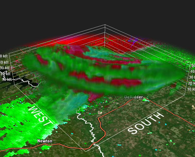
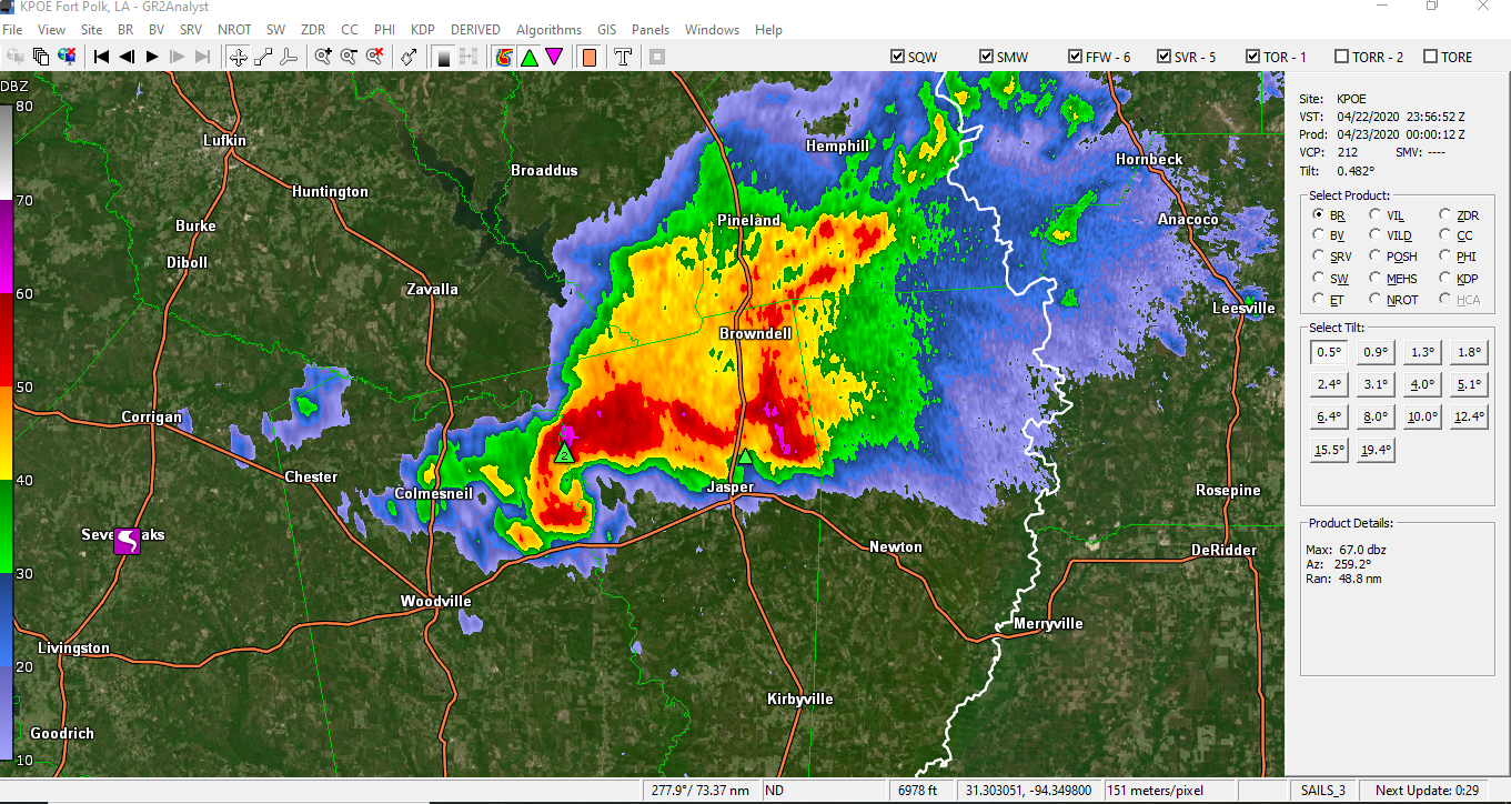
It looks like it began to cycle right before crossing South Fort Polk. Hopefully they were spared.
-
Really tightening up again
-
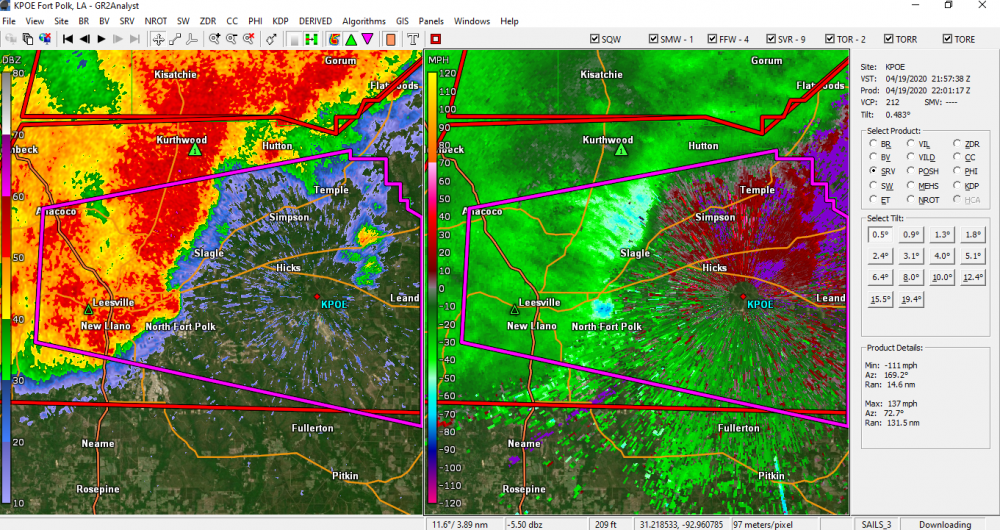
Classic hook on this. It does not look good for Jasper.

-
11 minutes ago, Amped said:
That southernmost cell needs to be watched carefully.
Good call....Tornado warned now
-
Trees uprooted and a roof blown off a home reported in Leesville, couplet appeared to pass directly over town.
-
This is going to get extremely close to the Fort Polk radar site, if this holds together.
-
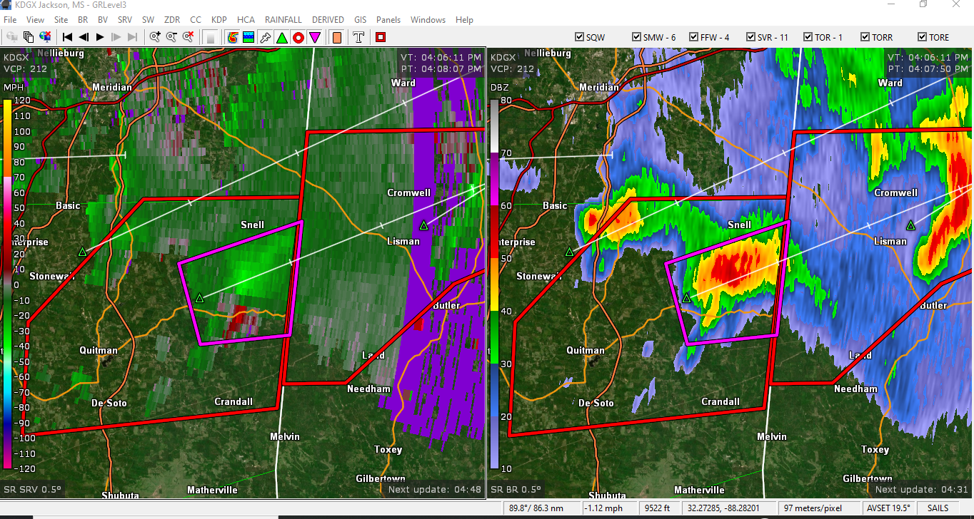
Decent couplet just south of Snell

-
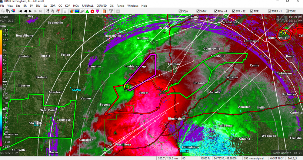
New tornado warning north of Birmingham now.


2/14- 2/16 Winter Storm and Arctic Cold
in Tennessee Valley
Posted
Looks like Memphis pushed up the start of the WSW due to impacts from the snow currently falling. Picked up a half inch or so here in the past few hrs.