

WestTennWX
-
Posts
87 -
Joined
Content Type
Profiles
Blogs
Forums
American Weather
Media Demo
Store
Gallery
Posts posted by WestTennWX
-
-
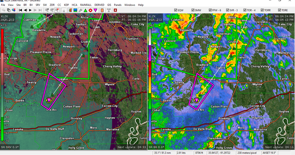
New Tornado warned cell near Georgetown.
-
14 minutes ago, Chinook said:
interesting note: dew points may be 23 to 28 degrees F above normal in the Louisiana-Arkansas area, as well as 20+ above normal along the Mississippi and Ohio Valleys.
That is insane considering the arctic blast that we just experienced only a week ago. Dewpoint here (NW TN) has been holding at 66 for a few hours now. Temp hit 70 this afternoon, and a week ago we had wind chills approaching 30 below.
-
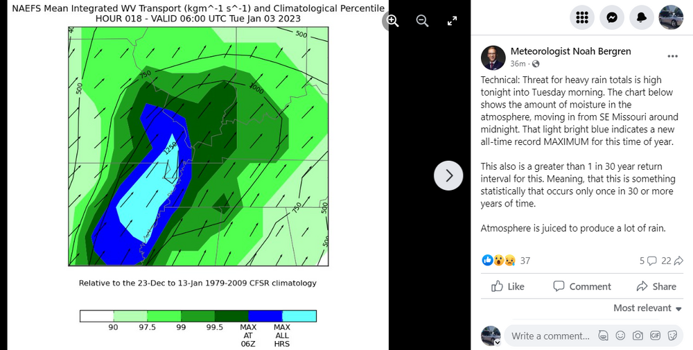
Local met just posted an interesting stat regarding flooding potential. Going to be a long night for a lot us either way.
-
Far NW Tennessee here....one thing I can say is as we approach the 1 year anniversary of the December 10th tornado, storm awareness has increased substantially, to the point of storm anxiety in many cases. Schools have made decisions to cancel games, close early, etc. ahead of this event, ( a good call IMO). Given a year ago I'm not sure that would have happened. Many communities have yet to rebuild and people in this area are just on edge.
Curious to see how far north the instability gets tomorrow. Could be a higher end event in NW TN and West KY if we get those dewpoints up...plenty of shear to be tapped into. Glad this thread is somewhat active.
-
 1
1
-
-
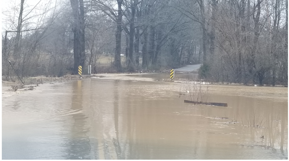
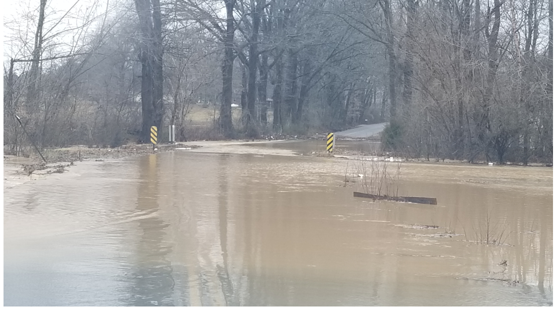
Pretty much a worst case scenario for that area. I live about 50 miles west and have been down that way a few times, it is indeed a flood plain. No way would I rebuild there. This area has a past history of flooding, but what made this exceptional was the massive amount of rain upstream. Residents keep referring to it as a tidal wave.
-
1
-
-
22 hours ago, dwagner88 said:
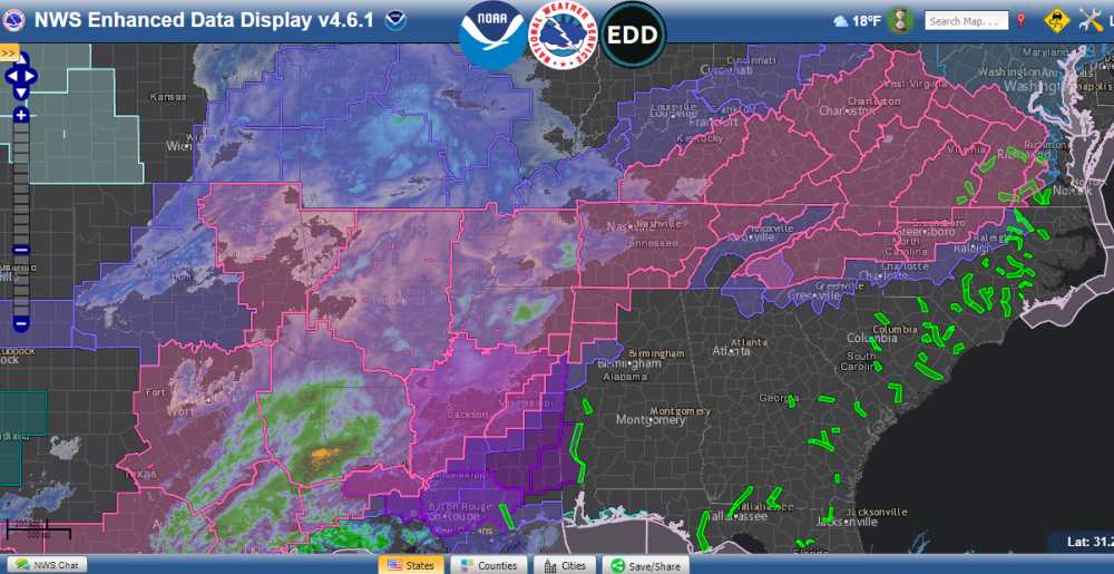
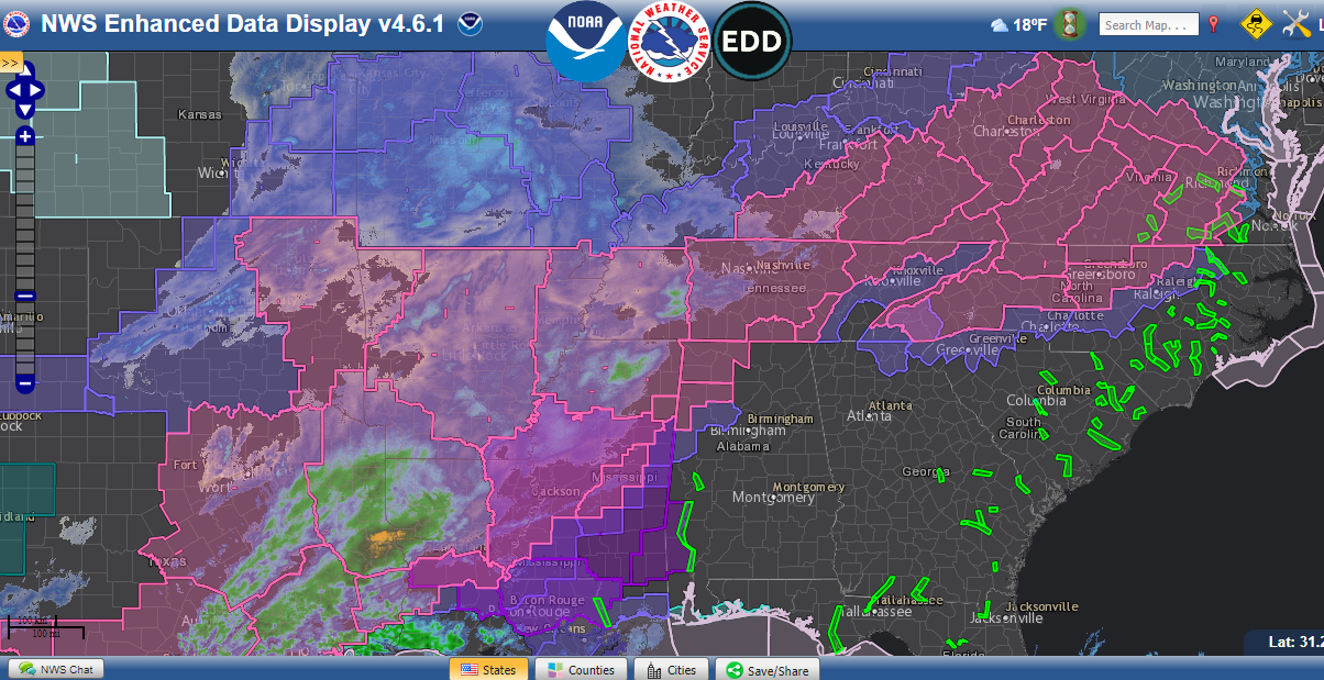
Western parts of middle TN have been hit with catastrophic flash flooding this morning. Dual pol estimates max out at over 17” of rain near McEwen TN.
There is a tragedy unfolding in Humphreys county as we speak. 15 now confirmed dead, and dozens still missing. Many of the dead and missing are children. Not a lot of media coverage on this, unfortunately. Some of the photos coming out of Waverly are just breathtaking. NWS Nashville recorded a record shattering 17.02 inches of rain in a 24 hour period. Some of the worst Flash Flooding I have ever seen.
-
 1
1
-
-
Pretty nasty line that moved through West TN about 4 am. Over 8 thousand without power in my area. I'd estimate 60-70 mph gusts
-
1
-
-
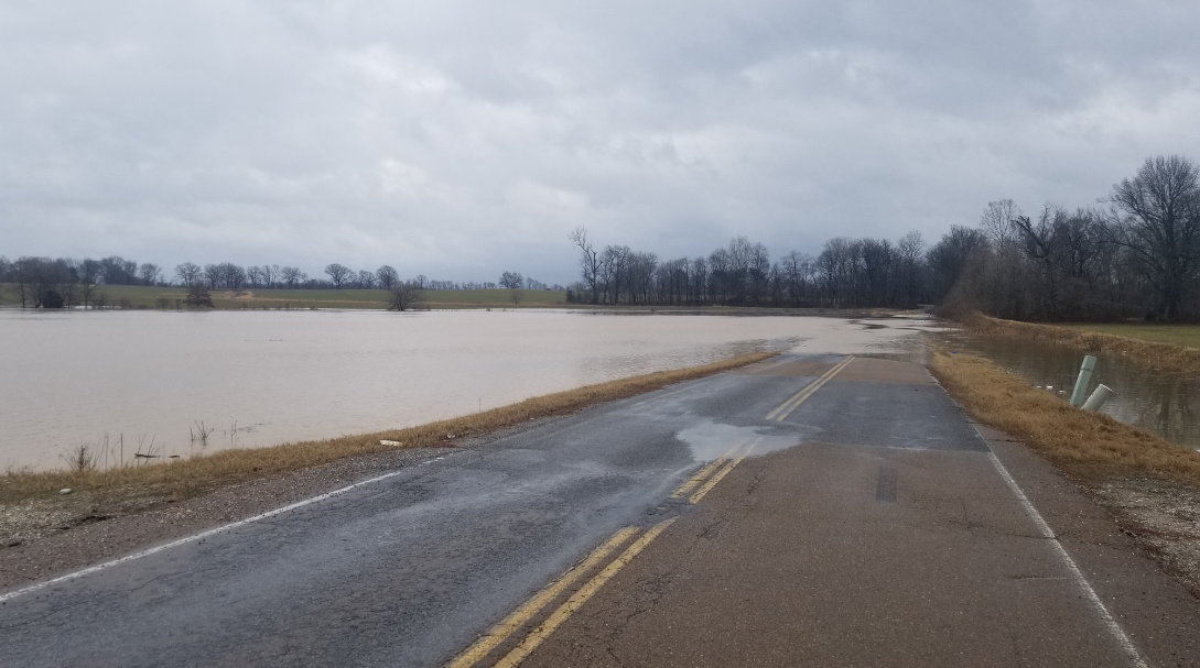
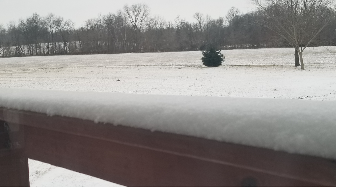
Picked up over 3 and a half inches of rain this morning in Obion County. Several reports of culverts and bridges washed out as well. Snapped these around 9 am.

-
2
-
 1
1
-
1
-
-
Just now, mempho said:
HUGE Flakes here!
Sent from my SM-G950U using Tapatalk
Same here in Union City, picked up an inch so far...coming down at a pretty good rate too. If we avoid any dry slot/dry air, we could pick up a few more inches
-
2
-
-
Official totals have been bumped down here in far NW TN with the SE trend. An impressive string of advisories/warnings with this one too. Hopefully some of you guys will cash in
-
2
-
-
Clouds cleared out overnight here allowing the temps to really bottom out. Minus 1 this morning, -9 wind chill
-
3
-
-
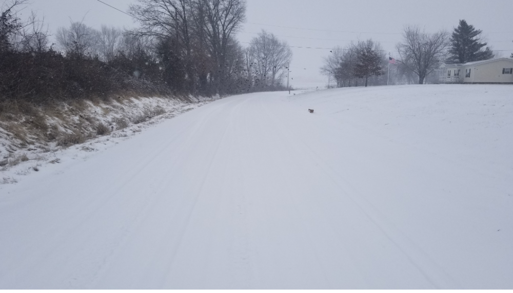
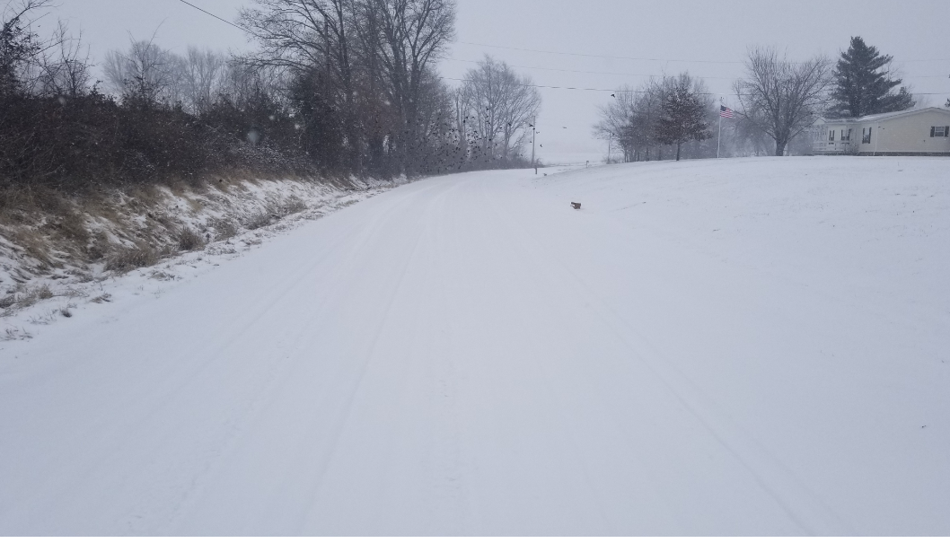
Snow starting to wind down here. Kind of hard to tell here but this photo was taken in the road in front my house. Going to be a fun commute in the morning!
-
7
-
-
About half an hour ago In Union City

-
4
-
-
Hoping to get under a good band before this is over, it has been only light to moderate snowfall so far. Still managed to rack up about 3 and a half inches this morning.
-
4 minutes ago, AMZ8990 said:
It’s most definitely gonna bust low here
I'm thinking maybe 5-6 here, on the low end for sure. Not complaining tho!
-
1
-
-
Starting to see some of the heavier returns settle in my way, starting to see some nice accumulations in a few areas
-
4
-
-
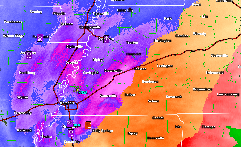
Both PAH and MEM morning discos mention up to 20:1 snow ratios for this afternoon....unreal for this area
8 degrees this morning with a wind chill of -11. Gusts to 24. Brutal!
From PAH:
Additionally, with very cold tropospheric temperatures,
snow-to-liquid ratios of 10-15:1 this morning are forecast to
increase to 15-20:1 by this afternoon. So the combination of the
strong forcing, high QPF, and high SLRs will contribute to very
efficient snow accumulation. Overall, storm total snow accumulation
of 6 to 10 inches is expected, with some localized totals up to a
foot. Add in the north winds of 10 to 15 mph with gusts up to 20
to 25 mph, and blowing and drifting snow will be a problem. All
this adds up to a serious situation that will cripple the flow of
traffic and commerce in the region. And dangerously cold sub zero
wind chills in many locations heightens the threat to life. As a
result, the Winter Storm Warning will continue through tonight.
MEM:
Short term...(Today through Tuesday)...An 850 mb low will move
from Central Arkansas today northeast into the Ohio Valley
tonight. Ample moisture and strong large scale forcing combined
with a very cold arctic airmass will continue to produce wintry
precipitation across the Mid-South throughout the day and heavy
at times this morning and into this afternoon. Analysis of short
term model soundings indicates precipitation will remain snow over
Northeast Arkansas, the Missouri Bootheel, and Northwest
Tennessee, initially a mix of sleet and snow along and south of
I-40 and gradually transitioning to all snow this morning near the
Mississippi River and gradually across the remainder of West
Tennessee into this afternoon. Snow ratios will average from 20:1
near the MO/KY border to 15:1 towards North Mississippi. Meanwhile,
precipitation across most of North Central and Northeast
Mississippi will be a mixture of sleet and freezing rain then
gradually transitioning to snow towards the end of the event
towards this evening. Areas to the southeast of Tupelo are most
likely to experience freezing rain for much of the event and the
Winter Storm Warning was transitioned over to an ice storm warning
where one quarter to one half inch of ice accumulation may occur.
-
3
-
-
24 minutes ago, CG2 said:
Time for people in west TN to wake-up and give us some updates!!!
Slept in a little later than I wanted to this morning..haha
Most of what is covering the ground we picked up with the last wave that came through sometime between 3 and 6, I'd say an an inch and a half to two inches

-
4
-
-
3 minutes ago, Stovepipe said:
Friend in Paris says this is starting as sleet despite the p-type radar indicating snow.

I was wondering how close some of the p-type algorithms are to actual conditions on the ground. The progression of this Arctic air has been a gem to watch unfold.
-
4
-
-
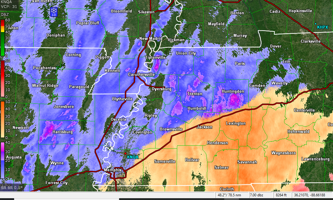
Radar starting to fill in. It will be interesting to see how some of the short term models handled this first wave

-
3
-
-
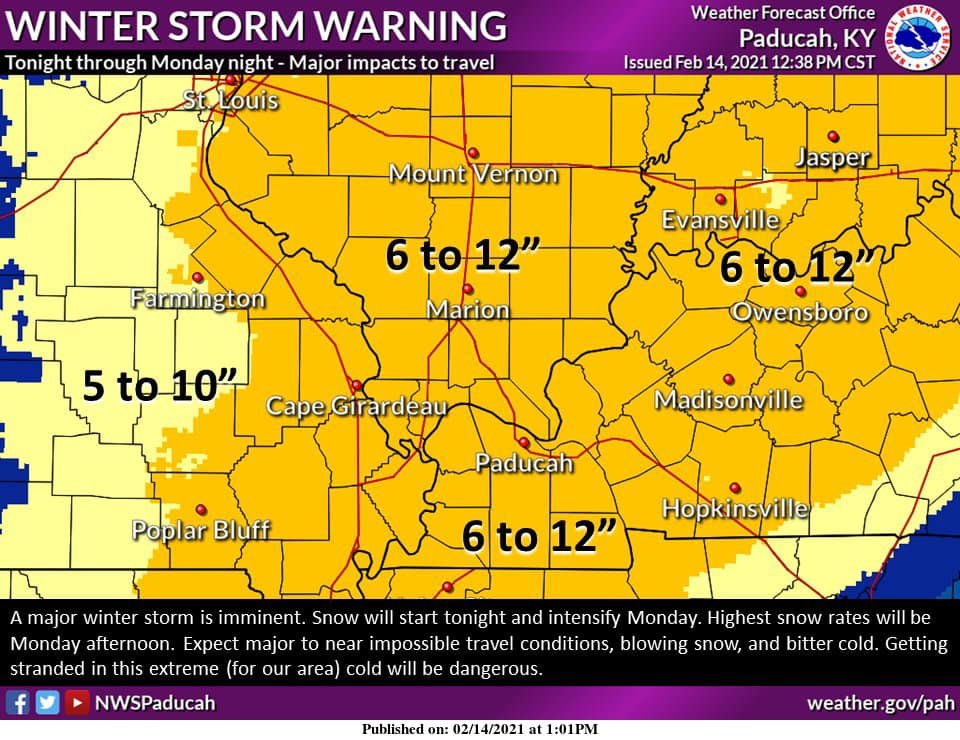
PAH Disco hinting at an excess of a foot where banding sets up-
National Weather Service Paducah KY
238 PM CST Sun Feb 14 2021

.SHORT TERM...(Tonight through Monday night)
Issued at 238 PM CST Sun Feb 14 2021

A major winter storm is taking aim on the area. The first round of
snow will be tonight in a zone of increasing low/mid trop
frontogenetical forcing positioned out ahead of the main upper trof,
that by 12z Monday should be over the central and southern Plains.
We may see an initial 1-3" of snow tonight (give or take). We have
incorporated the HREF closely with a consensus of deterministic
guidance for tonight and Monday (see below). We will be close to
Wind Chill Advisory conditions again tonight across portions of
southeast MO and southwest IL. We have addressed the bitter cold in
our current Winter Storm Warning that remains as is from 6 PM
Tonight through 6 AM Tuesday.

Monday, the main energy within the mid level trof comes up over top
of the region in the afternoon and evening. This will be the round
of greatest significance (snow rates, accumulations, impacts). The
overall trend seems a bit faster, so the lull is not expected to
last real long.

WPC banding probabilities increase notably with the main wave, with
some inference of instability and prominent snowfall rates. The HRRR
depicts this possibility as well. So for now we have storm total
accumulations 6 to 12". Given above average snow to liquid ratios
and this added concern, 12" may not be high enough should some of
these indicators pan out. But for now, we have headed the right
direction in our opinion.

The snow will taper off Monday evening and should be all but
completely over across southwest IN and the KY Pennyrile region
after midnight.

In terms of messaging, the bitter cold remains a real concern with
this system, as does the potential for blowing snow with NNE winds
10 to 15 mph gusts to 20 mph or even slightly higher. Stay tuned for
updates and adjustments to snow amounts (if needed).

.LONG TERM...(Tuesday through Sunday)
Issued at 238 PM CST Sun Feb 14 2021

The main focus later this week continues to be another potential
winter storm Wednesday into Thursday. This system is still four days
away, so many details remain to be ironed out. The 500 mb pattern
actually appears more complex than it did yesterday, mainly because
a northern stream 500 mb shortwave has entered the picture. This
northern stream shortwave will move down into the northern Plains
mid-week. There is some potential for this shortwave to shunt our
moist southern stream shortwave further south. This is reflected in
a majority of the model qpf fields, which show the heavy qpf
suppressed more to the south of the Ohio Valley than they did
yesterday. There is also less of a warm air intrusion, which results
in less mixing of wintry precip.

In a nutshell, the 12z models are still split into two camps. The
European solutions have trended even farther to the southeast,
taking the surface low northeast from the central Gulf Coast to
Georgia. The gfs ensemble mean is also further southeast, taking the
surface low across Alabama Thursday. The gfs consensus basically
places our region in the sweet spot for heavy snow, with heavy qpf
shown by the gfs ensemble mean over the Ohio Valley and se Missouri.
An elevated warm nose in the gfs guidance would result in mixing
with sleet or freezing rain se of the Ohio River.

Until the models resolve the influence of the northern stream
shortwave, the forecast will remain in flux. A forecast trend toward
drier and colder conditions is possible if the northern stream
becomes more dominant. The models at face value today do continue to
suggest the likelihood of a winter storm Wednesday into Thursday.
Otherwise, the main story on Tuesday into Wednesday will be the
continued bitterly cold wind chills.

Following the late week winter storm system, high pressure will pass
overhead on Friday. In the wake of the high, southwest winds are
expected to bring above freezing temps this weekend following the
extended winter blast. The ecmwf and gfs mos highs in the 50s at pah
Sunday look a little unrealistic given the snowcover, so the
forecast will be for highs in the 40s. Model ensemble means have
been in good agreement on a nearly zonal flow aloft this weekend.

&&
-
3
-
-
2 minutes ago, dwagner88 said:
That’s a little bit ambiguous. Do they mean it will be the longest since the 40’s? Or that 4 days is the longest stretch since the 40’s? The latter would surprise me.
I would assume they mean when all is said and done, the consecutive days below freezing will be the longest. Saturday is currently forecast to be 38, gotta wonder if we will make that with inches of snowpack likely still on the ground.
-
2
-
1
-
-
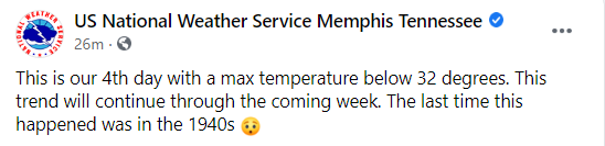
Interesting stat out of Memphis concerning temps, the extent and duration of this Arctic mass is impressive to say the least
-
6
-
1
-
-
NWS Paducah is starting to get on board w/some of the higher totals, they just posted this graphic...was 6-8 this morn
-
1
-


January 2nd and 3rd Severe Weather Threat
in Central/Western States
Posted
I just had that conversation with a family member. Those clusters are headed my way in 2 to 3 hours. Gotta be up at 4 am and its hard to sleep in this kind of setup. HRRR has a nice line coming in about 3 am as well in my area. Shear will be on the uptick and I would imagine there will be a few QLCS spinups along that line.