
paweather5
-
Posts
405 -
Joined
-
Last visited
Content Type
Profiles
Blogs
Forums
American Weather
Media Demo
Store
Gallery
Posts posted by paweather5
-
-
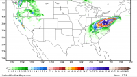
Looks like tornado warning in York
-
@losetoa6 are you in the Hanover area today? That stuff in York is crazy heavy. Going to take a drive soon but flash flood warning has to be coming.
-
Man Etna, Pa near Pitt is having some major issues already. Evacuations of the town currently.
-
Second time this morning very heavy rain. When you get under the red cells it pours but not for real long period.
-
Was just going to say Bedford to Chambersburg getting slammed already.
-
Harrisburg: 8.5
Lancaster: 6 northern, southern 3 to 4.
York: northern York 8, southern 4 to 5.
Tamaqua: 7
Williamsport: 2.5
State College: 2.5
Chambersburg: 8
Clearfield: 3
I am going bigger on this event. See a lot of upside potential. Who ever gets under the Convection and training could get 8 to 10. I think we might see one or two localized 11 to 12 inch amounts.
-
 1
1
-
-
48 minutes ago, losetoa6 said:
Hrrr pops a few cells later on this evening fwiw

Boy that would be crazy way to kick off this rain event.
-
11 minutes ago, Jns2183 said:
Harrisburg all time September daily rainfall record set during Lee is 7.17”. I thought I was going bout on a limb earlier in the week comparing this to Lee. I don’t even know anymore, but if Harrisburg gets 9”+ in 24 hours it’s going to be real bad.
.Thanks for posting those maps. Looks like all models agree pretty well right now. Going to say 6 to 10 is a real possibility around Harrisburg, Adams, York and few other places.
-
Storms starting to fire up, whoever gets hit will make Tuesday worst if euro is correct.
-
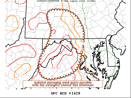 Took this from mid Atlantic forum, might be another active evening.
-
21 minutes ago, paweather said:
Almost 200 pages!
I think this is the most active I have ever seen this group since I joined in 2010. Summer was always 5 post a week type deal.
-
2
-
-
17 minutes ago, Bubbler86 said:
More rescues?
Rescues getting dispatched as we speak. 2 active few road closures.
-
 1
1
-
-
It is absolutely dumping in York right now.
-
1 minute ago, Itstrainingtime said:
2 kernels of popcorn to note - there are showers near and east of Dillsburg and just west of Pillow. Both locations have been consistently scoring the past several weeks.
I was just saying this, got a pretty solid downpour but didn’t last long. I was telling my wife it has rained more days in a row then I can remember.
-
from last night storm that area got hit hard.
Newberry Township is coordinating the following in response to the widespread power outage in the Grandview Section of Newberry Township:
There is a water distribution station at the NTPD Field Operations Unit located the the intersection of Grandview Drive and Hill Drive until 1400 hours.
There is a cooling / comfort station opening at the Newberry Township Fire Company located at 2145 York Haven Road. Facial coverings will be required to enter the cooling/ comfort station.
The Newberry Township Fire Company will also be traveling through the effected areas to distribute water to residents.
Residents are encouraged to follow Newberry Township official social media outlets and the township Website for updates. Newberry Township, York County Pennsylvania Newberry Township Fire Department (103)
-
About 5 minutes to the east of me got nailed last night. That have pictures on Facebook they posted.
Newberry Township Fire Department
Crews handled 5 calls between 2315 on 8/12/21 and 0205 on 8/13/21. Crews encountered what appears to be a very large wind storm that rolled through a portion of box 31-01, calls ranged from trees down, 2 dispatched trees on structures, and wires down. Crews encountered multiple other trees on structures with severe damage to minimal damage, fortunately no injuries occurred from any of these incidents. All equipment housed within the department were out assisting with clean up and the emergency incidents -
12 minutes ago, Itstrainingtime said:
You're near Ski Roundtop? I wonder how much damage there was at Pinchot...
I’m on pinetown road, the road the leads back to roundtop. It’s seem to have hit this area hard driving around. Looks like it stayed just north of Pinchot.
-
Man that storm did a lot of damage in the area. Trees down all over. On my road few people with roof damage. Massive tree through the middle of a shed. I know a trampoline is the first thing to go but mine flew about 2 miles down the road. Had dime sized hail for a little as well.
-
Just got smoked by ski roundtop, hail and very strong winds.
-
1
-
-
Hope this helps but it’s been like this since fall.
Pinchot Lake’s water level has been lowered approximately five feet to allow repairs and improvements at several shoreline locations. These projects include an ADA accessible fishing pier in the Conewago Day Use Area, easier entry into the water at the swimming beach in the Quaker Race Day Use Area, and boat launch improvements at Boat Mooring 3. The lake is open to both fishing and boating during this time, but launching boats is difficult due to the water level. We anticipate the lake being at normal pool around Memorial Day. Check this page for updates.
-
1
-
-
Didn’t expect this but heavy sleet with some snow two miles from ski roundtop.
-
Looks like the gfs drops near a foot Thursday for most in LSV.
-
 1
1
-
-
Euro look amazing some reason can’t post it.
-
1 minute ago, Bubbler86 said:
I just hit 14". 5 inches in the last two hours. Its intense
What your location that’s pretty awesome congrats.

Central PA - Winter 2021/2022
in Upstate New York/Pennsylvania
Posted
Am I missing something? On tropical tidbits don’t even have a storm.