

RCNYILWX
-
Posts
3,173 -
Joined
-
Last visited
Content Type
Profiles
Blogs
Forums
American Weather
Media Demo
Store
Gallery
Posts posted by RCNYILWX
-
-
We're in process of upgrading Ogle county to WSW and holding WWA east of there for now. May revisit the decision again before 3pm.
Sent from my SM-G965U using Tapatalk-
 1
1
-
 2
2
-
-
I think it can get there.Pretty large shift in the heaviest snow locally, now the axis is M59 and north vs I-69 and north. One or two more shifts and this would slam Detroit.
Sent from my SM-G965U using Tapatalk
-
Baby steppin06z GFS ticked south as well.
Edit: 6+ along i88 and north.

Sent from my SM-G965U using Tapatalk
-
3
-
 7
7
-
-
Best quality snow of the season here, true fluff. Nice little overperformer event.
Sent from my SM-G965U using Tapatalk -
What's amazing is that the Euro is not quite as cold aloft as the GFS at peak magnitude but would still threaten to break the all time coldest 850 at ILX.12z Euro has about -33C to -35C overhead at 850 mb from 6 am Wed through Wed afternoon.
Sent from my SM-G965U using Tapatalk
-
Don't expect this to verify of course, but still, things you never thought you'd see on a 4 day model for $1000, Alex

Sent from my SM-G965U using Tapatalk
-
Since the coldest temperature of the 2000s, -18 on 1/16/09, happened on a good radiational cooling night with only about -20 to -21 at 850 mb, have to account for that possibility.I really feel that way. Wednesday morning has the better argument for being colder at ORD whether or not it's all-time record breaking. We may have a starting point that we've rarely or never seen before on Wednesday evening so wanted to respect that.
Sent from my SM-G965U using Tapatalk
-
The top 5 coldest temps at ORD all had 15+ mph winds so I think best shot is the peak advection Wednesday morning.Still a bit out there, but we are getting close enough to be able to dive into some specifics.
I'd say there could be a couple shots to approach the all-time record low at ORD. The first coming on Wednesday morning, which is more of an advective driven cold at that point with a bitter airmass aloft and winds staying fairly elevated. Then another one potentially coming on Thursday morning after having an extremely cold starting point Wednesday evening. Overall, Wednesday night/Thursday morning certainly looks like a better radiational cooling setup than Wednesday morning, though even then it appears the winds may not completely die off especially in/around the city. Also, the airmass aloft looks like it will be warming by late Wednesday into Thursday, so not having full decoupling could be a problem.
I'm still not ready to predict an all-time record low for ORD, but to me, if it happens, the better chance of it occurring is on Wednesday morning because that is when the radiational cooling component is minimized, and anybody who pays attention knows that ORD can have problems with radiating. That being said, Thursday can't be ruled out due to what was mentioned above about the extremely cold starting point.
Just my 2 cents and thoughts subject to change.
Sent from my SM-G965U using Tapatalk
-
I think it includes today's event. Best way to compare is to check the map at weather.gov/lot/winter. We've been focusing on the Sunday night-Monday event in the storm total map there.That might include today's snow, but not sure. Maybe RC can chime in.
Sent from my SM-G965U using Tapatalk
-
It's all about longitude it comes in at before it starts to track due east. I have my doubts it comes in notably farther north than GFS/NAM, though obviously can't fully rule it out. If it comes in farther west and makes it farther south before east turn, will help northern IL. As it is, GEM did shift back south and shows a solid event I-88 and north, with warning criteria northern tier, not too far off from last few runs of Euro.With things as is, models have trended N and is that northward model movement pretty much as far as it will go? Just curious in the probabilities of this thing jumping 100 miles north (for example).
My non meteorologist inclination is that in this environment (cold air in place, snow pack in IL and IA, etc) that there are better chances of this thing riding the temp gradient south than pushing more north where it is already cold?
Model above is a nice hit for pretty much all of WI and MI. Damn that cutoff in N IL...
This is just a tough setup to model correctly and hinges upon the evolution described above. The models really aren't that far off at this point, kind of like hurricane track forecast errors a few days out, but the small differences matter for us.
Sent from my SM-G965U using Tapatalk
-
1
-
-
12z GGEM

Sent from my SM-G965U using Tapatalk-
2
-
1
-
-
Even more of an impressive gradient between you and ARR, which was down to -24 last hour.Zero here in East Chicago. Amazing what a relatively small amount of distance coupled with less snowfall can do.
Sent from my SM-G965U using Tapatalk
-
-28 at SQI.
Sent from my SM-G965U using Tapatalk -
Yep great point, yet another reason to take a step back from reading too much into every operational run.A thing I noticed even in the short term that I am sure you did as well is in Canada the evolution of the vort for this storm, starts out small then breaks in two, originally the storm going south was focusing on the southern half of the vort, now it is focusing on the northern and eastern half of the vort. I question if it even splits to begin with, which would have huge ramifications down the line.
Sent from my SM-G965U using Tapatalk
-
Is it really a northern shift or just the majority of operational models favoring a more northerly track? They're on the northern end of the ensemble spread and could be outliers in their own right, we just don't know. Most important element is where the system enters the CONUS. Euro still has a strong surface low for a clipper/hybrid at 997 mb over southern IA then weakening a bit eastward, but most importantly it enters the CONUS farther west than the farther north op models.
Hate to overuse the lack of sampling argument, but I really think the multiple moving parts, complex evolution, angle of approach, make it that we're unlikely to have consensus until we get more observed data on the important features. Chiefly the primary wave coming ashore into northern BC later tomorrow. I continue to think that I-80 and north in IL into southern WI will do well, with highest totals I-88 and north, and going to hold with that thinking until things become more clear.
Sent from my SM-G965U using Tapatalk
-
1
-
5
-
-
Big hit I-80 and north. Good to see but also doesn't change the fact that nothing is set in stone with so many moving parts.
Sent from my SM-G965U using Tapatalk-
3
-
2
-
-
Good point. Spread actually increased on 12z GEFS vs 06z GEFS, showing the sensitive nature of the pattern evolution for this hybrid. We have 2 PV pieces dropping south over Canada that will play a role, another northern stream wave dropping southeast over Canada, and the parent short wave is well out over Pacific in the Gulf of AK. It won't be fully ashore into northern BC until tomorrow afternoon/evening.To RCNY point above the 12Z operational GFS was north of the 6z but the 12Z GEFS is better than the 6z GEFS
I think it is probably safe to say that areas south of I-80 are less likely to get into the potential 6"+ snow swath at this point but areas north still certainly in the game.
Sent from my SM-G965U using Tapatalk
-
1
-
3
-
-
Still pretty sizable spread on the GEFS. The operational model trends except for UKMET are what they are today, though not gonna punt this for northern IL. This synoptic setup is a tough one for the models to nail and some of the important features are in a data void area.


Sent from my SM-G965U using Tapatalk-
2
-
1
-
-
What's your definition of DAB? Looks like 1-2" there, or right around 2" if you go by latest HRRR/RAP and Euro and GEMs. Toss the NAMs.Looks like a DAB at best for here with today’s snow. Was hoping for a little uptick, but not seeing it. Should be some decent mood snows at the least...
Sent from my SM-G965U using Tapatalk
-
I don't buy the 00z NAM for tomorrow. Looks like classic NAM dry air issues with the unrealistic splotches of qpf/snow only where the model thinks saturation is sufficient. SREF only had one member with no measurable snow at ORD.
Edit: Referring to 00z NAM12. 3km NAM looks much more realistic.
-
1
-
1
-
-
I think if trends hold tomorrow could be a sneaky disaster commute in the Chicago area. Bitterly cold temps and road treatments don't mix and fluffy arctic snow is already pretty slick. If today's dendrites are a sign of what tomorrow may be like, 20-25:1 ratios could fluff up to 1-3", maybe even a bit higher in spots. Wouldn't be surprised if a WWA is issued considering the timing coinciding with the PM commute.
Sent from my SM-G965U using Tapatalk -
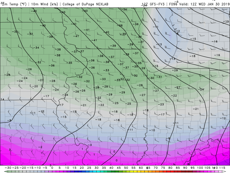
The 06z GFS took the cake for most extreme solution for cold here. -41 at 850 at 12z Wednesday, with 500 mb heights touching 489 in far northeast IL and 1000-500 thicknesses in the 470s. We're at the point where moderation of what's being modeled will still give -30 or so at 850.
Noon 2m temps over northern IL on Wednesday in the low-mid -20s on the 06z GFS, just incredible stuff.
-
 1
1
-
-
Actually bottoms out at -34 at ORD Friday morning, insane.What is Chicago's coldest temperature ever? Euro has -31 and -33 at day 8.5 for ORD and MDW.
Sent from my SM-G965U using Tapatalk
-
Much better radiational cooling setup next Wednesday night/Thursday morning on this run of the Euro. Unbelievably cold min temps modeled in IA and IL. Looks like spots of -40ish in north central IA.
Sent from my SM-G965U using Tapatalk-
2
-
Hybrid Clipper Event 1/27-1/29
in Lakes/Ohio Valley
Posted
Sent from my SM-G965U using Tapatalk